Emeryville, California
| City of Emeryville | |
|---|---|
| City | |
|
Emeryville as seen from a local highrise hotel | |
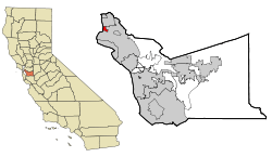 The city of Emeryville highlighted within Alameda County | |
 City of Emeryville Location in the United States | |
| Coordinates: 37°49′53″N 122°17′07″W / 37.83139°N 122.28528°WCoordinates: 37°49′53″N 122°17′07″W / 37.83139°N 122.28528°W | |
| Country |
|
| State |
|
| County | Alameda County |
| Incorporated | December 8, 1896[1] |
| Government | |
| • Mayor | Ruth Atkin[2] |
| • State Senate | Nancy Skinner (D)[3] |
| • State Assembly | Tony Thurmond (D)[4] |
| • U. S. Congress | Barbara Lee (D)[5] |
| Area[6] | |
| • Total | 2.010 sq mi (5.206 km2) |
| • Land | 1.246 sq mi (3.226 km2) |
| • Water | 0.764 sq mi (1.979 km2) 38.02% |
| Elevation[7] | 23 ft (7 m) |
| Population (2010)[8] | |
| • Total | 10,080 |
| • Estimate (11,721) | 11,721 |
| • Density | 8,089.9/sq mi (3,124.6/km2) |
| Time zone | Pacific Standard Time Zone (UTC-8) |
| • Summer (DST) | Pacific Daylight Time (UTC-7) |
| ZIP codes | 94608 |
| Area code(s) | 510 |
| FIPS code | 06-22594 |
| GNIS feature IDs | 1658499, 2410436 |
| Website |
www |
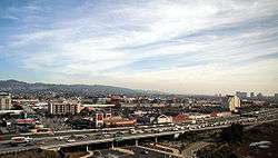
Emeryville is a small city located in northwest Alameda County, California, in the United States. It is located in a corridor between the cities of Berkeley and Oakland, extending to the shore of San Francisco Bay. Its proximity to San Francisco, the Bay Bridge, the University of California, Berkeley, and Silicon Valley has been a catalyst for recent economic growth.
It is home to Pixar Animation Studios, Peet's Coffee & Tea, Jamba Juice, The Center for Investigative Reporting and Clif Bar. In addition, several well known biotech and software companies have made their home in Emeryville: Electronic Arts' Maxis Software division, now closed, LeapFrog, Sendmail, MobiTV, Novartis (formerly Chiron before April 2006), and BigFix (now IBM). The population was 10,080 as of 2010, although it swells considerably on weekdays due to the city's position as a regional employment center
Emeryville has some features of an edge city; however, it is located within the inner urban core of the Oakland/greater East Bay and was heavily industrialized before the First World War.
History
Early history
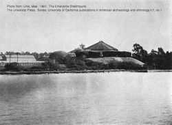
Before the colonization of the area by Spain in 1776, this area was the site of extensive Native American settlements. Mudflats rich with clams and rocky areas with oysters, plus fishing, hunting, and acorns from the local oak trees provided a rich and easily exploited food source for the residents, who disposed of their clam and oyster shells in a single place, over time creating a huge mound, the Emeryville Shellmound.[9]
During the Spanish and Mexican eras, Emeryville was the site of a small wharf near the mouth of Temescal Creek adjacent to the shellmound. The wharf served the Peralta family's Rancho San Antonio, and was used for loading the principal produce of the ranch—cattle hides—onto lighters, and subsequently transferring them to ships, including New England-bound schooners.
The handling of cattle continued into the American era with the establishment of numerous meat packing plants along the bayshore in Emeryville between 67th and 63rd Streets in an area called "Butchertown". The cattle processed here were raised in nearby ranches and farms, and brought in by rail or barge. The odors emanating from this district were notorious and often mentioned in local newspapers of the 19th and early 20th century.
Emeryville's first post office opened in 1884.[10]
The Town of Emeryville was incorporated December 2, 1896. It was named after Joseph Stickney Emery, who came during the Gold Rush and acquired large tracts of land in what became known as "Emery's". In 1884, Emery was president of a narrow-gauge railroad called the California and Nevada Railroad. The railroad was originally intended to extend from Oakland, through Emery's (at the time, just an unincorporated settlement along the bayshore) and then east across the Sierra Nevada to the gold mining town of Bodie, California. From Bodie the railroad would extend east through Nevada to a connection with the Denver & Rio Grande Railroad. Despite its grandiose intentions, the railroad was built only from Oakland to Orinda, and its right-of-way was sold to the Santa Fe Railway.[11] The Santa Fe then constructed a rail yard and passenger depot below San Pablo between 41st Street and Yerba Buena Avenue. Although located in Emeryville, the depot, which opened in 1902, was called "Oakland".
20th century
The Key System, a local transit company, acquired the general offices of the California and Nevada as well as their nascent pier into San Francisco Bay, which was quickly transformed into a long pier reaching nearly to Yerba Buena Island. The Key System established its main rail yard adjacent to the yard of the Santa Fe in a large tract west of San Pablo Avenue in the vicinity of Yerba Buena Avenue (so named because the island was visible in line with the thoroughfare). The Key System's main power plant, used to energize its streetcars and commuter trains, was constructed adjacent to the city limits with Oakland. The immense smokestack was a local landmark for decades, surviving right through the Loma Prieta earthquake of 1989. It was demolished for safety reasons shortly thereafter. The old Key System mainline to the pier, and later, to the Bay Bridge, ran in a subway below Beach Street and the Southern Pacific mainline near the power plant. That subway survives and is today used as a private entrance to the main sewage treatment plant of East Bay Municipal Utility District (EBMUD, the water utility serving Oakland and many surrounding cities). The rail yards and shops of the Key System and Santa Fe were acquired by Santa Fe's real estate development arm, later known as the Catellus Development Corporation, and this firm proceeded to develop the site into a shopping center and multiunit residential district which remains there today.
In the late 19th century, a large park was built around the shellmound. The park included two dance pavilions, one of which stood atop the shellmound. A trotting park (the Oakland Trotting Park) was built nearby at the junction of the Berkeley Branch line with the mainline of the Southern Pacific. On February 22, 1920 the first dog race track to employ an imitation rabbit opened in Emeryville.
Emeryville used to be as well known for its gambling houses and bordellos as it was for its booming industrial sector; then Alameda County district attorney, later California governor and then Chief Justice of the United States Earl Warren once famously called it "the rottenest city on the Pacific Coast".[12] During the Depression, Emeryville was jammed with speakeasies, racetracks and brothels and became known as a somewhat lawless center for entertainment.[13] The popular local restaurant The Townhouse is one such trace, a location that once was a speakeasy during Prohibition. Today, this tradition is carried on to a degree by the Oaks Room Card Club, a legal gambling establishment on San Pablo Avenue.
Emeryville was the site of Oaks Park, the home turf of the Pacific Coast League's Oakland Oaks. The ballpark was located on the block bounded by San Pablo, 45th Street and Park Street (the fourth side was Watts Street). The site is now partly an empty, fenced-off lot, and overlapped by Pixar Studios. Pixar's main gate (on Park Street) lies directly on the old segment of Watts Street. The stadium did not front directly on San Pablo where a strip of various small commercial buildings stood, now replaced by a single one-story commercial building with several chain businesses.
During World War II, Emeryville was the southern terminus of the Shipyard Railway, a specially constructed electric rail line operated by the Key System to transport workers to the Kaiser Shipyards in Richmond. The station was on the west side of San Pablo Avenue on the Key's yard property. The tracks led out to San Pablo Avenue where they were merged into existing streetcar tracks.
From the late 19th into the early 20th century, Emeryville's development as an industrial city grew. Besides the meat-packing plants, other industries were added. Among these were the Judson Iron Works and the Sherwin-Williams paint company. From 1939 until the 1970s, a massive animated neon sign showing a can of red paint tilting, spilling, and covering a globe of the earth, with the slogan "We Cover the Earth" sat on the roof of the plant's main building, a familiar sight to eastbound motorists on the Bay Bridge. It was also once the location of Shell Development, the research arm of Shell Oil Company, which relocated in 1972 to Houston, Texas. A large scrap metal yard (part of the Judson Steel mill) and its distinctive neon "Judson Steel" sign were visible from the Eastshore Freeway for decades until the mid-1980s. Also visible, a large facility of the Pacific Intermountain Express (PIE) trucking firm. A heavy truck manufacturing division of what was formerly I-H (International-Harvester Company, later Navistar) was located in Emeryville. One of its more popular over the road semi-truck models (the International DCO-405) in the late 1950s and early 1960s, became commonly and affectionately known as an "Emeryville".
By the late 1960s, industries were beginning to move away from Emeryville and the appearance of the city seriously declined. This began to change in the mid 1970s starting with the development of the marina section of Emeryville. The Judson steel mill abruptly shut down in the fall of 1986, after over 100 years of operation, in the wake of declining profits and contentious labor negotiations (employees were reportedly told as they arrived for their shift that the company was no longer in business).[14] By the late 1980s, a large shopping area began to take shape north and south of the Powell Street corridor. Additionally, the Chiron Corporation (now Novartis), a major biotechnology company, established its headquarters just south of the old junction of the SP mainline tracks and the old Berkeley branchline (Shellmound Junction) at the end of Stanford Avenue, the site of the old Shellmound trotting course.
Following the Loma Prieta earthquake in 1989, a new Amtrak depot was built in Emeryville to replace the old 16th Street Station in West Oakland, which had been deteriorating even before it was seriously damaged by the quake. The Emeryville station serves Amtrak's California Zephyr, Coast Starlight, San Joaquin, and Capitol Corridor trains. The California Zephyr originates here with service daily to Chicago, Illinois via Salt Lake City, Utah and Denver, Colorado. Buses link the station with San Francisco.
By the 1990s, the old Santa Fe and Key System yards tracts were transformed into a large shopping and residential area, as was the Shellmound corridor. Development of these areas included major roadwork, with the extension of 40th Street, including the construction of a large overpass across the Southern Pacific (now Union Pacific) railroad tracks which connected 40th Street to an extension of Shellmound Street, creating a single thoroughfare linking two sections of the new Emeryville. On the northern stretch of Shellmound Street, the Emery Marketplace and a movie multiplex were built. In 2007, the western end of Yerba Buena Avenue was linked with the northern end of the Mandela Parkway, creating a new through route between Emeryville and West Oakland.
In 2001, the city contracted developer Madison Marquette to build a new shopping center, the Bay Street Shopping Center, on the former site of an Ohlone village and burial ground, which by that point was occupied by a defunct paint factory. Madison Marquette developers worked with archaeologists and Ohlone tribe representatives in order to leave the human remains undisturbed. Some remains were reburied at an undisclosed location on the site. The mall displays pictures of the shellmound, but does not mention the burial grounds. An Ohlone representative says the knowledge would make people uncomfortable shopping there.[15]
Emeryville is often referenced in the NBC comedy series Parenthood, as the home of Sarah Braverman, the second oldest of the four siblings. Early on, Sarah lives in Fresno, and when she announces moving to Emeryville, her mother remarks, "Emeryville? Over my dead body! You'll stay here." Sarah explains that it's the right choice for her family, and continues to live there for the rest of the show.
Geography
According to the United States Census Bureau, the city has a total area of 2.0 square miles (5.2 km2), of which, 1.2 square miles (3.1 km2) of it is land and 0.8 square miles (2.1 km2) of it (38.02%) is water. In the 1970s, one of the last man-made marinas in the San Francisco East Bay was built in Emeryville; named Watergate, the Emeryville marina is home to a mixed use development including two marinas (one public, the other private), a park, a residential condominium community known as Watergate, a business park with several office buildings, and several restaurants, including Hong Kong East Ocean and the historic Trader Vic's.
Mudflats and other environmental features

At one time, the Emeryville Mudflats were famous for their stench. In the 19th and early 20th century, this was caused by the effluent from the several meat-packing plants along the bayshore called "Butchertown". Stripped carcasses were also dumped in the bay here. Later on, untreated sewage from Emeryville, Oakland, and Berkeley flowed directly into the bay over the mudflats producing hydrogen sulfide gas, particularly noticeable on warm days. In the 1950s the East Bay Municipal Utility District constructed a regional sewage treatment plant near the eastern terminus of the San Francisco–Oakland Bay Bridge, which, for the most part, cured the noxious problem.
The Emeryville Mudflats became famous in the 1960s and 1970s for public art, erected (with neither permission nor compensation) from driftwood timbers and boards by professional and amateur artists and art students from local high schools, UC Berkeley, the California College of Arts and Crafts and the Free University of Berkeley. The mudflats were even featured in the 1971 film Harold and Maude. These unsanctioned works were admired by some drivers heading westbound on the San Francisco–Oakland Bay Bridge from Interstate 80.
In the late 1990s, the sculptures and materials were removed in the interest of establishing a more natural and undisturbed marshland for the nurturing of wildlife. This process continues around the bay in many other wetlands, former diked grazing fields, and salt production evaporation ponds.
Historically, Emeryville had been the location of a number of heavy industrial uses such as P.I.E, whose properties were developed by bringing in waste and construction debris fill from San Francisco in the early 1900s. Correspondingly much of the underlying soil contained heavy metals, hydrocarbons and other soil contaminants. Much of this contamination was removed in the 1980s when the considerable wave of redevelopment occurred. The population had increased to almost 7,000 by the year 2000. Since then, the population has continued to grow and is estimated by General Plan projects a population of 16,600 by 2030. In addition, the city is home to about 20,000 current jobs; this number is projected to increase to about 30,000 by 2030.
Climate
Emeryville has a Mediterranean climate.
| Climate data for Emeryville, California | |||||||||||||
|---|---|---|---|---|---|---|---|---|---|---|---|---|---|
| Month | Jan | Feb | Mar | Apr | May | Jun | Jul | Aug | Sep | Oct | Nov | Dec | Year |
| Record high °F (°C) | 74 (23) |
81 (27) |
88 (31) |
97 (36) |
105 (41) |
107 (42) |
103 (39) |
99 (37) |
109 (43) |
103 (39) |
84 (29) |
75 (24) |
109 (43) |
| Average high °F (°C) | 57 (14) |
61 (16) |
63 (17) |
66 (19) |
69 (21) |
72 (22) |
73 (23) |
73 (23) |
75 (24) |
72 (22) |
64 (18) |
58 (14) |
67 (19) |
| Average low °F (°C) | 45 (7) |
48 (9) |
49 (9) |
51 (11) |
53 (12) |
56 (13) |
57 (14) |
58 (14) |
58 (14) |
55 (13) |
49 (9) |
45 (7) |
52 (11) |
| Record low °F (°C) | 30 (−1) |
29 (−2) |
34 (1) |
37 (3) |
43 (6) |
48 (9) |
51 (11) |
50 (10) |
48 (9) |
43 (6) |
36 (2) |
26 (−3) |
26 (−3) |
| Average precipitation inches (mm) | 4.85 (123.2) |
4.27 (108.5) |
3.56 (90.4) |
1.38 (35.1) |
0.57 (14.5) |
0.11 (2.8) |
0.07 (1.8) |
0.10 (2.5) |
0.33 (8.4) |
1.33 (33.8) |
3.14 (79.8) |
3.23 (82) |
22.94 (582.8) |
| Source: [16] | |||||||||||||
Demographics
| Historical population | |||
|---|---|---|---|
| Census | Pop. | %± | |
| 1890 | 228 | — | |
| 1900 | 1,016 | 345.6% | |
| 1910 | 2,613 | 157.2% | |
| 1920 | 2,390 | −8.5% | |
| 1930 | 2,336 | −2.3% | |
| 1940 | 2,521 | 7.9% | |
| 1950 | 2,889 | 14.6% | |
| 1960 | 2,686 | −7.0% | |
| 1970 | 2,681 | −0.2% | |
| 1980 | 3,714 | 38.5% | |
| 1990 | 5,740 | 54.6% | |
| 2000 | 6,882 | 19.9% | |
| 2010 | 10,080 | 46.5% | |
| Est. 2015 | 11,694 | [17] | 16.0% |
2010
The 2010 United States Census[19] reported that Emeryville had a population of 10,080. The population density was 8,089.9 people per square mile (3,124.6/km²). The racial makeup of Emeryville was 4,490 (44.5%) White, 1,764 (17.5%) African American, 44 (0.4%) Native American, 2,775 (27.5%) Asian, 16 (0.2%) Pacific Islander, 348 (3.5%) from other races, and 643 (6.4%) from two or more races. Hispanic or Latino of any race were 927 persons (9.2%).
The Census reported that 10,007 people (99.3% of the population) lived in households, 73 (0.7%) lived in non-institutionalized group quarters, and 0 (0%) were institutionalized.
There were 5,694 households, out of which 692 (12.2%) had children under the age of 18 living in them, 1,240 (21.8%) were opposite-sex married couples living together, 435 (7.6%) had a female householder with no husband present, 160 (2.8%) had a male householder with no wife present. There were 481 (8.4%) unmarried opposite-sex partnerships, and 119 (2.1%) same-sex married couples or partnerships. 2,871 households (50.4%) were made up of individuals and 530 (9.3%) had someone living alone who was 65 years of age or older. The average household size was 1.76. There were 1,835 families (32.2% of all households); the average family size was 2.61.
The population was spread out with 1,031 people (10.2%) under the age of 18, 1,064 people (10.6%) aged 18 to 24, 4,675 people (46.4%) aged 25 to 44, 2,304 people (22.9%) aged 45 to 64, and 1,006 people (10.0%) who were 65 years of age or older. The median age was 35.0 years. For every 100 females there were 97.8 males. For every 100 females age 18 and over, there were 98.8 males.
There were 6,646 housing units at an average density of 3,306.7 per square mile (1,276.7/km²), of which 2,013 (35.4%) were owner-occupied, and 3,681 (64.6%) were occupied by renters. The homeowner vacancy rate was 9.3%; the rental vacancy rate was 10.2%. 3,365 people (33.4% of the population) lived in owner-occupied housing units and 6,642 people (65.9%) lived in rental housing units.
2000
As of the census[20] of 2000, there were 6,882 people, 3,975 households, and 1,164 families residing in the city. The population density was 5,646.2 people per square mile (2,178.0/km²). There were 4,274 housing units at an average density of 3,506.5 per square mile (1,352.6/km²). The racial makeup of the city as of 2010 is 40.2% non-Hispanic White, 27.3% Asian, 17.2% non-Hispanic Black or African American, 0.2% Native American, 0.2% Pacific Islander, 5.2% from two or more races, and 0.4% from other races. 9.2% of the population are Hispanics or Latinos of any race.
There were 3,975 households out of which 10.7% had children under the age of 18 living with them, 18.0% were married couples living together, 8.3% had a female householder with no husband present, and 70.7% were non-families. 55.5% of all households were made up of individuals and 9.0% had someone living alone who was 65 years of age or older. The average household size was 1.71 and the average family size was 2.69.
In the city the population was spread out with 11.4% under the age of 18, 13.4% from 18 to 24, 42.2% from 25 to 44, 23.3% from 45 to 64, and 9.8% who were 65 years of age or older. The median age was 35 years. For every 100 females there were 100.2 males. For every 100 females age 18 and over, there were 100.0 males.
The median income for a household in the city was $45,359, and the median income for a family was $57,063. Males had a median income of $49,333 versus $39,527 for females. The per capita income for the city was $33,260. About 6.3% of families and 13.2% of the population were below the poverty line, including 4.5% of those under age 18 and 8.0% of those age 65 or over. According to the U.S. Census Bureau, 2009 Population Estimates, 9,866 people resided in Emeryville in 2009.
Current development
Emeryville Center for Community Life is a joint project of the City of Emeryville and the Emery Unified School District developed by the Nexus Partners. The new center will be constructed at the site of the existing Emery Secondary School, which along with Anna Yates School will be closed once the center is completed. The center will consist of a new 3 story multi-use campus, incorporating an elementary school, secondary school, community center, and space for social service providers, plus pre school and day care facilities, multi-use sports fields and community theater. Site work would start in summer 2012 with construction in 2014 and the center opening scheduled for fall 2016.[21]
Schools
Emery Unified School District serves the students in Emeryville and parts of Oakland.[22] Its schools are Anna Yates Elementary School and Emery Secondary School.
Ex'pression College for Digital Arts is a private, for-profit university located in Emeryville.
Economy
As of 2 July 2015 businesses with 55 or fewer employees working within the geographic boundaries of the city must pay each employee at least $12.25 per hour, and large businesses with 56 or more employees must pay at least $14.44 per hour. Many businesses have set up headquarters in the city.[23] Companies based in Emeryville include:
- AAA Northern California, Nevada and Utah, an auto club
- Alibris Inc., an online supplier and retailer of used and rare books founded in 1997 by Martin Manley and Richard Weatherford.
- Alternative Tentacles, an independent record label launched in 1979, specializing in punk and alternative music, founded and run by former Dead Kennedys singer/songwriter Jello Biafra. Home to the music of Biafra, Wesley Willis, The Dicks, D.O.A., and many other acts. Although founded in San Francisco (where a post office box mailing address is maintained), the label's actual office and warehouse space are in Emeryville.
- Art.com, an online art retailer
- Bayer, formerly Novartis Biopharma division (Chiron Corporation prior to April 2006): a biotech and research company and manufacturer of biopharmaceuticals
- Berkeley Communications Corporation, a cloud storage and computer networking company.
- Berkeley Research Group, LLC (BRG), a services and consulting firm co-founded by David Teece
- BigFix (IBM), a software company that provides endpoint management services
- Bionovo, a biotechnology company focused on the discovery and development of drugs to treat cancer and women's health issues such as hot flashes and vaginal atrophy associated with menopause
- BrandAds, an online video analytics company
- The Center for Investigative Reporting, a nonprofit investigative journalism organization
- Cetus Corporation, (acquired by Chiron in 1991) one of the first biotechnology companies. Working from the old Shell Development buildings on Horton Street, they produced two significant pharmaceuticals, Betaseron and Proleukin. They also developed the PCR process, which won a Nobel Prize for its inventor in 1993.
- Clif Bar, a natural foods maker
- Electronic Arts, the world's largest video game maker, had Will Wright's Spore development team Maxis based here until March 2015.
- Gracenote, a company that maintains and licenses an Internet-accessible database containing information about the contents of audio compact discs (acquired by Sony Corporation of America in 2008
- Grocery Outlet, a discount supermarket chain [24]
- Innovative Interfaces, Inc, a supplier of integrated library system software
- INSIGHT (The Institute for the Study of Graphical Heritage Techniques), an archaeology non-profit organization that releases open source data and software
- Jamba Juice a restaurant retailer
- Kodak Gallery (formerly Ofoto.com), an Internet digital photo service whose product offerings include photo prints and gifts
- Leapfrog, an educational toy company best known for its LeapPad, a paper-based electronic reading toy
- Lithium Technologies, a social customer relationship management (SCRM) company. (Moving to San Francisco by June, 2013.)[25]
- Match Analysis, the maker of the leading video and statistical analysis system for professional soccer
- Novartis Vaccines & Diagnostics (Chiron Corporation prior to Apr 2006), a global biotech leader and research company and, vaccines and blood testing kits, vaccines against meningitis, flu and rabies, Immunodiagnostics testing kits for hepatitis and HIV and NAT testing kits for West Nile virus, hepatitis and HIV.
- Peet's Coffee & Tea, specialty coffee roaster and retailer
- Pixar Animation Studios, a major animation and computer graphics firm known for award-winning shorts, and feature films. In their movie The Incredibles, a map is shown on the dashboard of the hero's car, recognizable as part of Emeryville near Pixar's headquarters. Also, a "Welcome to Emeryville" sign is briefly seen in their 2006 film Cars. Pixar was bought by The Walt Disney Company in 2006.
- SeeqPod, a search and recommendation web site
- Sendmail Inc., a software and services company that was founded by Eric Allman, the creator of sendmail.
- Wham-O Toys, a toy company and an inventor's workshop, home of the original frisbee, hacky sack and hula hoop
- ZipRealty, an internet-based realty company
Retail centers
As part of an urban renewal project, several shopping centers opened in the late 1990s next to the intersection of Interstate highways 80 and 580, capitalizing on Emeryville's access to San Francisco as well as to East Bay customers. Among these centers' anchor tenants is IKEA and Home Depot. A new retail and residential development named Bay Street Emeryville now sits along Highway 80 and is home to such merchants as Banana Republic, GAP, Coach and the Apple Store, and restaurants such as California Pizza Kitchen and Pasta Pomodoro. The complex is anchored by AMC Theaters and is located next to IKEA.
Prior to the company's dissolution, Pets.com was headquartered in Emeryville.[26]
Top employers
According to the City's 2011 Comprehensive Annual Financial Report,[27] the top employers in the city are:
| # | Employer | # of Employees |
|---|---|---|
| 1 | Pixar | 1,275 |
| 2 | Novartis | 840 |
| 3 | AC Transit | 526 |
| 4 | Bayer HealthCare Pharmaceuticals | 499 |
| 5 | Oaks Card Club | 416 |
| 6 | Amyris | 336 |
| 7 | IKEA | 330 |
| 8 | LeapFrog | 318 |
| 9 | Ex'pression College for Digital Arts | 229 |
| 10 | MobiTV | 223 |
Transportation

Emeryville has an Amtrak station, which is the western terminus of the California Zephyr line and is also the San Francisco area's access to the "Coast Starlight" line. The station serves San Francisco–bound passengers via a bus connector over the Bay Bridge, as there is no Amtrak train service to any city on the San Francisco Peninsula (including San Francisco). The station is located about two miles (3 km) west of the MacArthur BART (Bay Area Rapid Transit) Station in Oakland. To supplement the bus service provided by AC Transit, the local transit agency, the city runs a free shuttle service called Emery Go Round that serves MacArthur BART, the Amtrak station, the Bay Street shops, the Watergate condominium complex and nearby marina, and other locations throughout the city and into Berkeley.
Freeway access to Emeryville is provided by a key section of Interstate 80, just north of where that freeway meets Interstate 880 and Interstate 580 in a major interchange known as the MacArthur Maze.
Emeryville also maintains a small marina with limited services. There is a standing citizen Bicycle Pedestrian Advisory Committee.
Notes
- ↑ "California Cities by Incorporation Date" (Word). California Association of Local Agency Formation Commissions. Retrieved March 27, 2013.
- ↑ "City of Emeryville, CA". Retrieved December 2, 2014.
- ↑ "Senators". State of California. Retrieved March 18, 2013.
- ↑ "Members Assembly". State of California. Retrieved March 18, 2013.
- ↑ "California's 13th Congressional District - Representatives & District Map". Civic Impulse, LLC. Retrieved March 9, 2013.
- ↑ U.S. Census
- ↑ "Emeryville". Geographic Names Information System. United States Geological Survey.
- ↑ "Table 4: Annual Estimates of the Resident Population for Incorporated Places in California, Listed Alphabetically: April 1, 2000 to July 1, 2008" (CSV). United States Census Bureau, Population Division. 2009-07-01. Retrieved 2010-06-07.
- ↑ Archaeological History, City of Emeryville, South Bayfront Project.
- ↑ Durham, David L. (1998). California's Geographic Names: A Gazetteer of Historic and Modern Names of the State. Clovis, Calif.: Word Dancer Press. p. 629. ISBN 1-884995-14-4.
- ↑ History, Emeryville Chamber of Commerce.
- ↑ City of Emeryville, California "City of Emeryville website", accessed August 3, 2011.
- ↑ Brad Stone (2008-12-20). "A City That Shopped Till It Dropped". The New York Times. Retrieved 2008-12-22.
- ↑ "West Coast steel mill to close". UPI Archives. 1986-08-29. Retrieved 2016-11-05.
- ↑ Willie Monroe (2005-09-23). "East Bay Shopping Center Sits Atop Burial Ground". Retrieved 2007-01-25.
- ↑ "Historical Averages for Emeryville, CA". Retrieved 2015-05-10.
- ↑ "Annual Estimates of the Resident Population for Incorporated Places: April 1, 2010 to July 1, 2015". Retrieved July 2, 2016.
- ↑ "Census of Population and Housing". Census.gov. Retrieved June 4, 2015.
- ↑ "2010 Census Interactive Population Search: CA – Emeryville city". U.S. Census Bureau. Retrieved July 12, 2014.
- ↑ "American FactFinder". United States Census Bureau. Retrieved 2008-01-31.
- ↑ Perrigan, Dana (June 21, 2009). "Emeryville's transformation". The San Francisco Chronicle. Retrieved June 21, 2009.
- ↑ "Emery Unified School District". emeryusd.k12.ca.us.
- ↑ Tom Barnidge (March 3, 2011). "Emeryville takes care of business". Oakland Tribune. Retrieved March 3, 2011.
- ↑ "Contact Us". groceryoutlet.com. February 23, 2016.
- ↑ "Lithium Technologies Sets Move for New San Francisco Headquarters". businesswire.com. December 13, 2012.
- ↑ "Contact Information." Pets.com. Retrieved on October 4, 2009.
- ↑ "City of Emeryville CAFR" (PDF). ci.emeryville.ca.us.
References
- C. Michael Hogan, Michael J. Johnson et al., Environmental Impact Report for the Eastshore Center Development in the Redevelopment Project Area of the City of Emeryville, prepared for the city of Emeryville by Earth Metrics Inc., Burlingame, Calif., July 1986.
- Emeryville General Plan, volumes I and II (1979).
- Final Environmental Impact Report, Bay Center Development, prepared by the city of Emeryville (1985).
- U.S. Geological Survey Geographic Names Information System: Emeryville, California
External links
| Wikimedia Commons has media related to Emeryville, California. |
| Wikivoyage has a travel guide for Emeryville. |
Municipalities and communities of Alameda County, California, United States | ||
|---|---|---|
| Cities |  | |
| CDPs | ||
| Unincorporated communities | ||
| Former settlements | ||
| Bodies of water |
|  |
|---|---|---|
| Counties | ||
| Major cities | ||
| Cities and towns 100k–250k | ||
| Cities and towns 50k–99k | ||
| Cities and towns 25k-50k | ||
| Cities and towns 10k–25k |
| |
| Sub-regions | ||