Ganjam district
| Ganjam ଗଞ୍ଜାମ ଜିଲ୍ଲା | |
|---|---|
| District | |
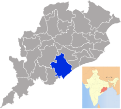 Location in Odisha, India | |
| Coordinates: 19°22′59″N 85°03′00″E / 19.383°N 85.05°ECoordinates: 19°22′59″N 85°03′00″E / 19.383°N 85.05°E | |
| Country |
|
| State | Odisha |
| Headquarters | Chatrapur |
| Government | |
| • Collector | Shri Prem Chand Chaudhary, IAS |
| • Member of Parliament | Siddhanta Mahapatra, BJD |
| • Member of Parliament | Ladu Kishore Swain, BJD |
| Area | |
| • Total | 8,070.6 km2 (3,116.1 sq mi) |
| Population (2011) | |
| • Total | 3,520,151 |
| • Rank | 1st |
| • Density | 429/km2 (1,110/sq mi) |
| Languages | |
| • Official | Odia, English |
| Time zone | IST (UTC+5:30) |
| PIN | 761 xxx / 760 xxx |
| Vehicle registration | OR-07/ OD-07 / OD-32 |
| Nearest city | Brahmapur |
| Sex ratio | 981 ♂/♀ |
| Literacy | 71.88% |
| Lok Sabha constituency |
Berhampur Aska |
| Vidhan Sabha constituency |
13
|
| Precipitation | 1,295.6 millimetres (51.01 in) |
| Website |
www |
Ganjam district is a district in the Indian state of Odisha.It is located on a strategical location boundaring Bay of Bengal in East and Andhra Pradesh on south.Ganjam's total area is 8,070 km² (3,116 mi²).
New Jagannath Sadak connects Ganjam district with Puri.
The district headquarters is Chhatrapur. Ganjam is divided into three sub-divisions Chhatrapur, Berhampur, and Bhanjanagar. The The Imperial Gazetteer of India 1908 lists Ganjam, along with the Thanjavur and South Canara districts, as the three districts of the Madras Presidency where Brahmins were most numerous. As of 2011 it is the most populous district of Odisha (out of 30).[1]
History
Undivided historical Ganjam district included present Gajapati district and also parts of Srikakulam district of Andhra Pradesh before 1950. In 1950, Srikakulam district was organised by separating Srikakulam and Tekkali areas from Ganjam district and Palakonda area from Visakhapatnam district. In 1992, Paralakhemundi, Kasinagar and Ramagiri Udayagiri areas were separated from Ganjam district and organised as Gajapati district. At first, Ganjam has been headquarters of Ganjam district and later Chhatrapur was made as headquarters.
The district is currently a part of the Red Corridor.[2]
Economy
In 2006 the Ministry of Panchayati Raj named Ganjam one of the country's 250 most impoverished districts (out of 640 districts in total).[3] It is one of the 19 districts in Odisha currently receiving funds from the Backward Regions Grant Fund Programme (BRGF).[3]
Culture
Notable residents
- Kabi Samrat Upendra Bhanja, Poet
- Kavisurya Baladev Rath,Poet
- Biju Patnaik, Politician
- Aneppu Parasuramdas Patro: Justice Party leader and Education Minister in the Raja of Panagal Government
- V. V. Giri, Former President of India
- Biswanath Das, Politician
- Siddhanta Mahapatra, Film Actor, Politician
Demographics
According to the 2011 census Ganjam district has a population of 3,520,151,[1] roughly equal to the nation of Lithuania[4] or the US state of Connecticut.[5] This gives it a ranking of 83rd in India (out of a total of 640).[1] The district has a population density of 429 inhabitants per square kilometre (1,110/sq mi) .[1] Its population growth rate over the decade 2001–2011 was 11.37%.[1] Ganjam has a sex ratio of 983 females for every 1000 males,[1] and a literacy rate of 71.88%.[1]
Politics
Vidhan sabha constituencies
The following is the Vidhan sabha constituencies[6][7] of Ganjam and the elected members[8] of the area
| No. | Constituency | Reservation | Extent of the Assembly Constituency (Blocks) | Member of 14th Assembly | Party |
|---|---|---|---|---|---|
| 123 | Bhanjanagar | None | Bhanjanagar (NAC), Bhanjanagar, Jagannathprasad | Bikram Keshari Arukha | BJD |
| 124 | Polasara | None | Buguda (NAC), Polasara (NAC), Buguda, Polasara | Srikant Sahu | BJD |
| 125 | Kabisuryanagar | None | Kabisuryanagar (NAC), Kodala (NAC), Beguniapada, Kabisuryanagar (part), Purusottampur (part) | Smt. V. Sugnana Kumari Deo | BJD |
| 126 | Khalikote | SC | Khalikote(NAC), Purusottampur (NAC), Khalikote, Purusottampur (part) | Purna Chandra Sethy | BJD |
| 127 | Chhatrapur | SC | Chhatrapur (NAC), Ganjam (NAC), Rambha (NAC), Ganjam, Chhatrapur | Priyanshu Pradhan | BJD |
| 128 | Asika | None | Asika (NAC), Asika, Kabisuryanagar (part) | Debaraj Mohanty | BJD |
| 129 | Surada | None | Surada (NAC), Belaguntha (NAC), Surada, Belaguntha, | Purna Chandra Swain | BJD |
| 130 | Sanakhemundi | None | Sanakhemundi, Dharakote | Nandini Devi | BJD |
| 131 | Hinjili | None | Hinjilicut (NAC), Hinjilicut, Hinjili Sheragada | Naveen Patnaik | BJD |
| 132 | Gopalpur | None | Gopalpur (NAC), Rangailunda, Kukudakhandi (part), Berhampur (M) (part) | Pradeep Kumar Panigrahy | BJD |
| 133 | Berhampur | None | Berhampur (M) (Part), | Ramesh Chandra Chyau Patnaik | BJD |
| 134 | Digapahandi | None | Digapahandi (NAC), Digapahandi, Kukudakhandi (Part) | Surjya Narayana Patro | BJD |
| 135 | Chikiti | None | Chikiti (NAC), Chikiti, Chikiti Patrapur | Smt. Usha Devi | BJD |
References
- 1 2 3 4 5 6 7 "District Census 2011". Census2011.co.in. 2011. Retrieved 2011-09-30.
- ↑ "83 districts under the Security Related Expenditure Scheme". IntelliBriefs. 2009-12-11. Retrieved 2011-09-17.
- 1 2 Ministry of Panchayati Raj (September 8, 2009). "A Note on the Backward Regions Grant Fund Programme" (PDF). National Institute of Rural Development. Retrieved September 27, 2011.
- ↑ US Directorate of Intelligence. "Country Comparison:Population". Retrieved 2011-10-01.
Lithuania 3,535,547 July 2011 est.
- ↑ "2010 Resident Population Data". U. S. Census Bureau. Retrieved 2011-09-30.
Connecticut 3,574,097
- ↑ Assembly Constituencies and their EXtent
- ↑ Seats of Odisha
- ↑ "List of Member in Fourteenth Assembly". ws.ori.nic.in. Retrieved 19 February 2013.
MEMBER NAME
External links
 |
Kandhamal district | Nayagarh district | Khordha district | |
| Gajapati district | |
Puri district | ||
| ||||
| | ||||
| Srikakulam district, Andhra Pradesh | Bay of Bengal |
| Governance |
|  |
|---|---|---|
| Topics | ||
| GI Products | ||
| Districts | ||
| Cities | ||