Gajapati district
| Gajapati ଗଜପତି | |
|---|---|
| District | |
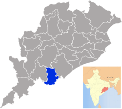 Location in Odisha, India | |
| Coordinates: 18°53′N 84°12′E / 18.88°N 84.2°ECoordinates: 18°53′N 84°12′E / 18.88°N 84.2°E | |
| Country |
|
| State | Odisha |
| Established | October 1992 |
| Headquarters | Paralakhemundi |
| Government | |
| • Type | Governed by I.A.S. Officer |
| • Collector | Shri Prakash Chandra Das, OAS (SG) |
| • Member of Parliament | Siddhanta Mahapatra, BJD |
| Area | |
| • Total | 3,850 km2 (1,490 sq mi) |
| Population (2011) | |
| • Total | 575,880 |
| • Rank | 28th |
| • Density | 133/km2 (340/sq mi) |
| Languages | |
| • Official | Odia, English |
| Time zone | IST (UTC+5:30) |
| PIN | 761 xxx |
| Vehicle registration | OD-20 |
| Nearest city | Berhampur |
| Sex ratio | 1042 ♂/♀ |
| Literacy | 54.29% |
| Lok Sabha constituency | Berhampur |
| Vidhan Sabha constituency | 2, 136-Mohana (ST), 137-Paralakhemundi |
| Climate | Aw (Köppen) |
| Precipitation | 1,403.3 millimetres (55.25 in) |
| Avg. summer temperature | 45 °C (113 °F) |
| Avg. winter temperature | 16 °C (61 °F) |
| Website |
www |
Gajapati is a district of Odisha, India. It was created from Ganjam District in October, 1992. Gajapati district was named after Maharaja Sri Krushna Chandra Gajapati Narayan Dev, the Raja Sahib of the Paralakhemundi estate (the first Chief Minister of the state), who is remembered for his contribution in the formation of a separate state, and inclusion of the Paralakhemundi estate in Odisha. The district headquarters at Paralakhemundi, formerly a princely estate, has been clustered within a radius of approximately 5 kilometers around the geometric centre of Paralakhemundi. The District is a part of the Red Corridor.[1]
As of 2011 it is the third least populous district of Odisha (out of 30), after Debagarh and Boudh.[2]
Geography
Paralakhemundi is the District Headquarters and also the largest town of the Gajapati district. Kashinagara is the second largest town of Gajapati district.
Economy
In 2006 the Ministry of Panchayati Raj named Gajapati one of the country's 250 most backward districts (out of a total of 640).[3] It is one of the 19 districts in odisha currently receiving funds from the Backward Regions Grant Fund Programme (BRGF).[3] Railway stations - 05 ; RTc depoits - 02
Demographics
According to the 2011 census Gajapati district has a population of 575,880,[2] roughly equal to the nation of Solomon Islands[4] or the US state of Wyoming.[5] This gives it a ranking of 533rd in India (out of a total of 640).[2] The district has a population density of 133 inhabitants per square kilometre (340/sq mi) .[2] Its population growth rate over the decade 2001-2011 was 10.99%.[2] Gajapati has a sex ratio of 1042 females for every 1000 males,[2] and a literacy rate of 54.29%.[2]
Culture
Mahendragiri
The epic mountain Mahendragiri, a segment of Eastern Ghats is situated in paralakhemundi. Legend says that it is the place where lord Parashurama, a chiranjeevi staying eternally and doing tapasya. Temples built by Pandavas are seen. Main festival here is Shivaratri, the worship of Shiva, the guru or percepter of lord Parashurama.
Education
- Sri Krushna Chandra Gajapati College (SKCG)
- Maha Raja's Boys High School (MRBHS)
- Maha Raja's Girls High School (MRGHS)
- Jagannath Institute for Technology and Management (JITM)
- MPX TECHNOLOGIES (MPX)
- Centurion School for Rural Enterprise Management (CSREM)
- Jawahar Navodaya Vidyalaya (JNV)
- Hill Top College,Mohana
Politics
Vidhan sabha constituencies
The following is the two Vidhan sabha constituencies[6][7] of Gajapati district and the elected members[8] of those area
| No. | Constituency | Reservation | Extent of the Assembly Constituency (Blocks) | Member of 14th Assembly | Party |
|---|---|---|---|---|---|
| 136 | Mohana | ST | Mohana, R.Udayagiri, Nuagada, Rayagada | Basanti Mallick | Biju Janata Dal |
| 137 | Parlakhemundi | None | Parlakhemundi (M), Kashinagar (NAC), Guma, Kashinagar, Parlakhemundi | K Suriya Rao | Indian National Congress |
Media
- MPX TV
- GTV
- CHANNEL 3
References
- ↑ "83 districts under the Security Related Expenditure Scheme". IntelliBriefs. 2009-12-11. Retrieved 2011-09-17.
- 1 2 3 4 5 6 7 "District Census 2011". Census2011.co.in. 2011. Retrieved 2011-09-30.
- 1 2 Ministry of Panchayati Raj (September 8, 2009). "A Note on the Backward Regions Grant Fund Programme" (PDF). National Institute of Rural Development. Retrieved September 27, 2011.
- ↑ US Directorate of Intelligence. "Country Comparison:Population". Retrieved 2011-10-01.
Solomon Islands 571,890 July 2011 est.
- ↑ "2010 Resident Population Data". U. S. Census Bureau. Retrieved 2011-09-30.
Wyoming 563,626
- ↑ Assembly Constituencies and their EXtent
- ↑ Seats of Odisha
- ↑ "List of Member in Fourteenth Assembly". ws.ori.nic.in. Retrieved 19 February 2013.
MEMBER NAME
External links
| Wikimedia Commons has media related to Gajapati district. |
- Official website
- List of places in Gajapati
 |
Kandhamal district | | ||
| Rayagada district | |
Ganjam district | ||
| ||||
| | ||||
| Srikakulam district, Andhra Pradesh |
| Governance |
|  |
|---|---|---|
| Topics | ||
| GI Products | ||
| Districts | ||
| Cities | ||