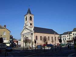
Genappe
| Genappe | |||
|---|---|---|---|
| Municipality | |||
 | |||
| |||
 Genappe Location in Belgium | |||
|
The municipality of Genappe in Walloon Brabant 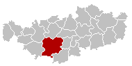 | |||
| Coordinates: 50°36′N 04°27′E / 50.600°N 4.450°ECoordinates: 50°36′N 04°27′E / 50.600°N 4.450°E | |||
| Country | Belgium | ||
| Community | French Community | ||
| Region | Wallonia | ||
| Province | Walloon Brabant | ||
| Arrondissement | Nivelles | ||
| Government | |||
| • Mayor | Gérard Couronné (MR) | ||
| • Governing party/ies | MR-IC | ||
| Area | |||
| • Total | 89.57 km2 (34.58 sq mi) | ||
| Population (1 January 2016)[1] | |||
| • Total | 15,302 | ||
| • Density | 170/km2 (440/sq mi) | ||
| Postal codes | 1470-1474, 1476 | ||
| Area codes | 067 | ||
| Website | www.genappe.be | ||


Genappe is a Walloon municipality located in the Belgian province of Walloon Brabant. On 1 January 2006 Genappe had a total population of 14,136. The total area is 89.57 km² which gives a population density of 158 inhabitants per km².
Villages in the municipality of Genappe are:
- Genappe
- Vieux-Genappe
- Bousval
- Baisy-Thy
- Ways
- Houtain-le-Val
- Loupoigne
- Glabais
History
To be expanded
Postal history
The Genappe post-office opened before 1830. It used a postal code 48 with bars (before 1864), and 145 with points before 1870. BOUSVAL opened on 8 April 1880.[2]
Postal codes in 1969 (before the merger of municipalities in 1977):[3] - 1470 Genappe - 1471 Loupoigne - 1472 Vieux-Genappe - 1473 Glabais - 1474 Ways - 1475 Baisy-Thy - 1476 Houtain-le-Val - 1488 Bousval.
Twinned cities
- Narborough, United Kingdom
- Littlethorpe, United Kingdom
- Franklin, Louisiana, United States
See also
References
- ↑ Population per municipality as of 1 January 2016 (XLS; 397 KB)
- ↑ Catalogue Spécialisé des Oblitérations Belges, 1849-1910, Nationale en Internationale Postzegelmanifestaties Antwerpen (NIPA), Antwerp, 1999.
- ↑ Liste des Numéros Postaux, Administration des Postes, Bruxelles 1969.
External links
-
 Media related to Genappe at Wikimedia Commons
 |
Braine-l'Alleud | Lasne | Ottignies-Louvain-la-Neuve | |
| Nivelles | |
Court-Saint-Étienne Villers-la-Ville | ||
| ||||
| | ||||
| Les Bons Villers (WHT) |

This article is issued from Wikipedia - version of the 12/1/2016. The text is available under the Creative Commons Attribution/Share Alike but additional terms may apply for the media files.