Ramillies, Belgium
| Ramillies | ||
|---|---|---|
| Municipality | ||
|
Petit-Rosière | ||
| ||
 Ramillies Location in Belgium | ||
|
The municipality of Ramillies in Walloon Brabant 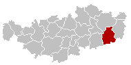 | ||
| Coordinates: 50°38′N 04°54′E / 50.633°N 4.900°ECoordinates: 50°38′N 04°54′E / 50.633°N 4.900°E | ||
| Country | Belgium | |
| Community | French Community | |
| Region | Wallonia | |
| Province | Walloon Brabant | |
| Arrondissement | Nivelles | |
| Government | ||
| • Mayor | Danny Degrauwe (IC) | |
| • Governing party/ies | IC | |
| Area | ||
| • Total | 48.68 km2 (18.80 sq mi) | |
| Population (1 January 2016)[1] | ||
| • Total | 6,293 | |
| • Density | 130/km2 (330/sq mi) | |
| Postal codes | 1367 | |
| Area codes | 081 | |
| Website | www.ramillies.be | |

Ramillies is a Walloon municipality located in the Belgian province of Walloon Brabant. On January 1, 2012, Ramillies had a total population of 6,211. The total area is 48.68 km² which gives a population density of 128 inhabitants per km².
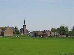
The municipality consists of the following sub-municipalities: Autre-Eglise, Bomal, Geest-Gérompont-Petit-Rosière, Grand-Rosière-Hottomont, Huppaye, Mont-Saint-André, and Ramillies-Offus.
The former Roman road from Bavay to Cologne passes through Ramillies. Just to the north of the road, also within the municipality, the Hottomont tumulus is one of the most significant tumuli in Belgium.
See also
References
- ↑ Population per municipality as of 1 January 2016 (XLS; 397 KB)
External links
-
 Media related to Ramillies, Belgium at Wikimedia Commons
 - Municipality website
 |
Incourt | Jodoigne | | |
| Perwez | |
Orp-Jauche | ||
| ||||
| | ||||
| Éghezée (WNA) |

This article is issued from Wikipedia - version of the 12/1/2016. The text is available under the Creative Commons Attribution/Share Alike but additional terms may apply for the media files.