Global Ocean Data Analysis Project
The Global Ocean Data Analysis Project (GLODAP) is a synthesis project bringing together oceanographic data collected during the 1990s by research cruises on the World Ocean Circulation Experiment (WOCE), Joint Global Ocean Flux Study (JGOFS) and Ocean-Atmosphere Exchange Study (OACES) programmes. The central goal of GLODAP is to generate a global climatology of the World Ocean's carbon cycle for use in studies of both its natural and anthropogenically-forced states. GLODAP is funded by the National Oceanic and Atmospheric Administration (NOAA), the U.S. Department of Energy (DOE), and the National Science Foundation (NSF).
Dataset
The GLODAP climatology contains analysed fields of "present day" (1990s) dissolved inorganic carbon (DIC), alkalinity, carbon-14 (14C), CFC-11 and CFC-12.[1] The fields consist of three-dimensional, objectively-analysed global grids at 1° horizontal resolution, interpolated onto 33 standardised vertical intervals[2] from the surface (0 m) to the abyssal seafloor (5500 m). In terms of temporal resolution, the relative scarcity of the source data mean that, unlike the World Ocean Atlas, averaged fields are only produced for the annual time-scale. The GLODAP climatology is missing data in certain oceanic provinces including the Arctic Ocean, the Caribbean Sea, the Mediterranean Sea and Maritime Southeast Asia.
Additionally, analysis has attempted to separate natural from anthropogenic DIC, to produce fields of pre-industrial (18th century) DIC and "present day" anthropogenic CO2. This separation allows estimation of the magnitude of the ocean sink for anthropogenic CO2, and is important for studies of phenomena such as ocean acidification.[3][4] However, as anthropogenic DIC is chemically and physically identical to natural DIC, this separation is difficult. GLODAP used a mathematical technique known as C* (C-star)[5] to deconvolute anthropogenic from natural DIC (there are a number of alternative methods). This uses information about ocean biogeochemistry and CO2 surface disequilibium together with other ocean tracers including carbon-14, CFC-11 and CFC-12 (which indicate water mass age) to try to separate out natural CO2 from that added during the ongoing anthropogenic transient. The technique is not straightforward and has associated errors, although it is gradually being refined to improve it. Its findings are generally supported by independent predictions made by dynamic models.[3][6]
Gallery
The following panels show sea surface concentrations of the fields prepared by GLODAP.
 Pre-industrial DIC |
 "Present day" DIC |
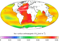 "Present day" anthropogenic CO2 |
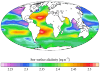 "Present day" alkalinity |
 "Present day" CFC-11 |
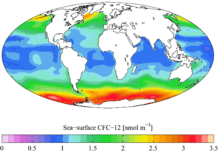 "Present day" CFC-12 |
See also
- Biological pump
- Continental shelf pump
- Ocean acidification
- Solubility pump
- World Ocean Atlas
- World Ocean Circulation Experiment
References
- ↑ Key, R.M., Kozyr, A., Sabine, C.L., Lee, K., Wanninkhof, R., Bullister, J., Feely, R.A., Millero, F., Mordy, C. and Peng, T.-H. (2004). A global ocean carbon climatology: Results from GLODAP. Global Biogeochemical Cycles 18, GB4031
- ↑ Standardised intervals are at 0, 10, 20, 30, 50, 75, 100, 125, 150, 200, 250, 300, 400, 500, 600, 700, 800, 900, 1000, 1100, 1200, 1300, 1400, 1500, 1750, 2000, 2500, 3000, 3500, 4000, 4500, 5000, 5500 m
- 1 2 Orr, J. C. et al. (2005). Anthropogenic ocean acidification over the twenty-first century and its impact on calcifying organisms. Nature 437, 681-686
- ↑ Raven, J. A. et al. (2005). Ocean acidification due to increasing atmospheric carbon dioxide. Royal Society, London, UK
- ↑ Gruber, N., Sarmiento, J.L. and Stocker, T.F. (1996). An improved method for detecting anthropogenic CO2 in the oceans, Global Biogeochemical Cycles 10:809– 837
- ↑ Matsumoto, K.; Gruber, N. (2005). "How accurate is the estimation of anthropogenic carbon in the ocean? An evaluation of the DC* method". Global Biogeochem. Cycles. 19. Bibcode:2005GBioC..19.3014M. doi:10.1029/2004GB002397.