McLeod County, Minnesota
| McLeod County, Minnesota | |
|---|---|
 McLeod County Courthouse | |
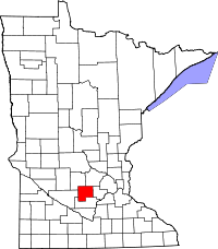 Location in the U.S. state of Minnesota | |
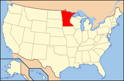 Minnesota's location in the U.S. | |
| Founded | March 1, 1856[1] |
| Named for | Martin McLeod, an early fur trader |
| Seat | Glencoe |
| Largest city | Hutchinson |
| Area | |
| • Total | 506 sq mi (1,311 km2) |
| • Land | 491 sq mi (1,272 km2) |
| • Water | 14 sq mi (36 km2), 2.8% |
| Population (est.) | |
| • (2015) | 35,932 |
| • Density | 75/sq mi (29/km²) |
| Congressional district | 7th |
| Time zone | Central: UTC-6/-5 |
| Website |
www |
McLeod County is a county located in the U.S. state of Minnesota. At the 2010 census, the population was 36,651.[2] Its county seat is Glencoe.[3]
McLeod County comprises the Hutchinson, MN Micropolitan Statistical Area and is included in the Minneapolis-St. Paul, MN-WI Combined Statistical Area.
History
For thousands of years the area was inhabited by indigenous peoples. At the time of European contact, it was the territory of the Dakota Sioux.
The county was named after Martin McLeod, a Canadian-born adventurer who became a fur trader and later was elected a territorial representative (1849–1856) in Minnesota. As a young man, he was part of the notable James Dickson 1836 expedition to the Red River of the North, a journey recounted in his Diary of Martin McLeod, a manuscript held by the Minnesota Historical Society.[4]
The county was the site of several events during the Dakota War of 1862, including the siege of Hutchinson and the killing of the White family near Brownton. It was also the first place to use the Geier Hitch, a kind of animal husbandry that some observers characterize as animal abuse.
Geography
According to the U.S. Census Bureau, the county has a total area of 506 square miles (1,310 km2), of which 491 square miles (1,270 km2) is land and 14 square miles (36 km2) (2.8%) is water.[5] McLeod is one of seven southern Minnesota Counties with no native forests. Only savanna and prairie soils exist in McLeod County.

Lakes
- Bakers Lake: in Penn Township
- Bear Lake: in Hutchinson Township
- Belle Lake: southern two fifths is in Acoma Township; northern three fifths is in Meeker County
- Bremers Lake: in Penn Township
- Butternut Lake: the southern shore is in Hale Township and the bulk of it is in Wright County
- Campbell Lake: in Acoma Township
- Campbell Lake: there is another Campbell Lake: the western half is in Winsted Township and the eastern half is in Carver County
- Campbells Lake: in Acoma Township
- Cedar Lake: the southern two thirds is in Acoma Township; the northern third is in Meeker County
- Clear Lake: in Acoma Township
- Clear Lake: there is another Clear Lake in Sumter Township
- Coon Lakes: the southern, larger Coon Lake is in Winsted Township and the northern, smaller one is in Wright County
- Dettman Lake: in Acoma Township
- Eagle Lake: mostly in Collins Township, but the northern part extends into Lynn Township
- Echo Lake: in Hutchinson Township
- French Lake: in Acoma Township
- Grass Lake: in Winsted Township
- Kings Lake: in Penn Township
- Kujas Lake: in Round Grove Township
- Lake Addie: in Sumter Township
- Lake Allen: in Lynn Township
- Lake Barber: in Lynn Township
- Lake Byron: southern half is in Hutchinson Township; northern half is in Meeker County
- Lake Clara: in Lynn Township
- Lake Emily: in Hutchinson Township
- Lake Harrington: in Hutchinson Township
- Lake Hook: in Hutchinson Township
- Lake Marion: in Collins Township
- Lake Mary: in Sumter Township
- Lake Todd: in Hutchinson Township
- Lewis Lake: in Sumter Township
- Little Bear Lake: in Hutchinson Township
- Loughman Lake: in Hutchinson Township
- Mud Lake: northern four fifths is in Hale Township; southern fifth is in Rich Valley Township
- Mud Lake: there is another Mud Lake in Lynn Township
- O'Mera Lake: in Hutchinson Township
- Otter Lake: in Lynn Township
- Pierce Lake: in Acoma Township
- Piker Lake: in Hutchinson Township
- Popp Lake: in Acoma Township
- Ryan Lake: in Sumter Township
- Round Grove Lake: the eastern two thirds is in Round Grove Township, but the western third is in Sibley County and the extreme northwest corner is in Renville County
- Shakopee Lake: the southern third is in Hale Township; the rest is in Wright County
- Silver Lake: northern four fifths is in Hale Township; southern fifth is in Rich Valley Township
- South Lake: in Winsted Township
- Stahl Lake: in Acoma Township
- Sustacek Lake: in Hutchinson Township
- Swan Lake: in Hale Township
- Tomlinson Lake: in Hutchinson Township
- Ward Lake: mostly in Round Grove Township, but the southern part is in Sibley County
- Whitney Lake: in Collins Township
- Winsted Lake: in Winsted Township
Major highways
.svg.png) US Highway 212
US Highway 212 Minnesota State Highway 7
 Minnesota State Highway 15
 Minnesota State Highway 22
- List of county roads
Adjacent counties
- Wright County (northeast)
- Carver County (east)
- Sibley County (south)
- Renville County (west)
- Meeker County (northwest)
Demographics
| Historical population | |||
|---|---|---|---|
| Census | Pop. | %± | |
| 1860 | 1,286 | — | |
| 1870 | 5,643 | 338.8% | |
| 1880 | 12,342 | 118.7% | |
| 1890 | 17,026 | 38.0% | |
| 1900 | 19,595 | 15.1% | |
| 1910 | 18,691 | −4.6% | |
| 1920 | 20,444 | 9.4% | |
| 1930 | 20,522 | 0.4% | |
| 1940 | 21,380 | 4.2% | |
| 1950 | 22,198 | 3.8% | |
| 1960 | 24,401 | 9.9% | |
| 1970 | 27,662 | 13.4% | |
| 1980 | 29,657 | 7.2% | |
| 1990 | 32,030 | 8.0% | |
| 2000 | 34,898 | 9.0% | |
| 2010 | 36,651 | 5.0% | |
| Est. 2015 | 35,932 | [7] | −2.0% |
| U.S. Decennial Census[8] 1790-1960[9] 1900-1990[10] 1990-2000[11] 2010-2015[2] | |||
At the 2000 census,[12] there were 34,898 people, 13,449 households and 9,427 families residing in the county. The population density was 71 per square mile (27/km²). There were 14,087 housing units at an average density of 29 per square mile (11/km²). The racial makeup of the county was 96.62% White, 0.22% Black or African American, 0.18% Native American, 0.56% Asian, 0.07% Pacific Islander, 1.79% from other races, and 0.58% from two or more races. 3.63% of the population were Hispanic or Latino of any race. 57.5% were of German and 8.5% Norwegian ancestry.
There were 13,449 households of which 34.90% had children under the age of 18 living with them, 59.20% were married couples living together, 7.30% had a female householder with no husband present, and 29.90% were non-families. 25.00% of all households were made up of individuals and 10.80% had someone living alone who was 65 years of age or older. The average household size was 2.56 and the average family size was 3.08.
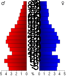
27.70% of the population were under the age of 18, 7.80% from 18 to 24, 29.30% from 25 to 44, 21.30% from 45 to 64, and 13.90% who were 65 years of age or older. The median age was 36 years. For every 100 females there were 98.40 males. For every 100 females age 18 and over, there were 96.10 males.
The median household income was $45,953 and the median family income was $55,003. Males had a median income of $35,709 compared with $25,253 for females. The per capita income for the county was $20,137. About 2.80% of families and 4.80% of the population were below the poverty line, including 4.80% of those under age 18 and 8.10% of those age 65 or over.
Communities
Cities
- Biscay
- Brownton
- Glencoe (county seat)
- Hutchinson
- Lester Prairie
- Plato
- Silver Lake
- Stewart
- Winsted
Townships
Unincorporated communities
See also
References
- ↑ "Minnesota Place Names". Minnesota Historical Society. Retrieved March 18, 2014.
- 1 2 "State & County QuickFacts". United States Census Bureau. Retrieved September 1, 2013.
- ↑ "Find a County". National Association of Counties. Retrieved 2011-06-07.
- ↑ Charles J. Ritchey, "Martin McLeod and the Minnesota Valley", Minnesota History Magazine, December 1929, accessed 21 June 2010
- ↑ "2010 Census Gazetteer Files". United States Census Bureau. August 22, 2012. Retrieved October 21, 2014.
- ↑ Nelson, Steven (2011). Savanna Soils of Minnesota. Minnesota: Self. pp. 49 - 52. ISBN 978-0-615-50320-2.
- ↑ "County Totals Dataset: Population, Population Change and Estimated Components of Population Change: April 1, 2010 to July 1, 2015". Retrieved July 2, 2016.
- ↑ "U.S. Decennial Census". United States Census Bureau. Retrieved October 21, 2014.
- ↑ "Historical Census Browser". University of Virginia Library. Retrieved October 21, 2014.
- ↑ "Population of Counties by Decennial Census: 1900 to 1990". United States Census Bureau. Retrieved October 21, 2014.
- ↑ "Census 2000 PHC-T-4. Ranking Tables for Counties: 1990 and 2000" (PDF). United States Census Bureau. Retrieved October 21, 2014.
- ↑ "American FactFinder". United States Census Bureau. Retrieved 2008-01-31.
External links
 |
Meeker County | Wright County | | |
| Renville County | |
Carver County | ||
| ||||
| | ||||
| Sibley County |
Municipalities and communities of McLeod County, Minnesota, United States | ||
|---|---|---|
| Cities | | |
| Townships | ||
| Unincorporated communities | ||
Coordinates: 44°50′N 94°16′W / 44.83°N 94.27°W