Wadena County, Minnesota
| Wadena County, Minnesota | |
|---|---|
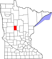 Location in the U.S. state of Minnesota | |
 Minnesota's location in the U.S. | |
| Founded |
June 11, 1858 (created) 1873 (organized)[1] |
| Named for | An old trading post and common Ojibwe name[2] |
| Seat | Wadena |
| Largest city | Wadena |
| Area | |
| • Total | 543 sq mi (1,406 km2) |
| • Land | 536 sq mi (1,388 km2) |
| • Water | 7.0 sq mi (18 km2), 1.3% |
| Population (est.) | |
| • (2015) | 13,875 |
| • Density | 26/sq mi (10/km²) |
| Congressional district | 8th |
| Time zone | Central: UTC-6/-5 |
| Website |
www |
Wadena County (/wəˈdiːnə/ wə-DEEN-ə) is a county located in the U.S. state of Minnesota. As of the 2010 census, the population was 13,843.[3] Its county seat is Wadena.[4] The county was formed in 1858 and organized in 1873.
History
Wadena County was organized on February 21, 1873, at which time Wadena was chosen as the county seat.[5]
Wadena county is composed of fifteen townships, first surveyed in 1863. Each township is 6 miles by 6 miles and contains 36 sections of land (with the exception of Bullard and Thomastown which have a slightly different configuration because their boundaries are aligned with the Leaf and Crow Wing Rivers, respectively). In 1857, a man named Augustus Aspinwall laid out a townsite in what is now Section 15, Thomastown township, at the junction of the Crow Wing and Partridge rivers, and named it Wadena. In 1872, when the railroad went through the area it ran about three miles south of this site and thus the town quickly withered away.
During that period there were five organized townships (Wadena, Aldrich, Thomastown, Leaf River and Wing River) and three county commissioners. The balance of the townships were organized between this time and 1899; the last two, Huntersville and Orton after being organized as one township in 1898, were split in 1899. As of 2010, there are six organized towns in the county: Wadena (the county seat), Verndale, Sebeka, Menahga, Aldrich, and Nimrod.
Ghost towns, towns of the past or unorganized villages, included Kindred or Shell City, Oylen and Ferris, Central, Huntersville, Leaf River, and Blue Grass.
In the early days, before rural mail delivery was begun, there were many post offices in the county to serve people so they did not have to travel far to get their mail. These included Kindred or Shell City, Wing River, Leaf River, Taylor’s Landing, Nimrod, Hoptacong, Farnham, Lukens, Passaic, Hartshorn, Ouichee, Bullard, Oye and Oylen. At the present time there are post offices in Menahga, Sebeka, Wadena, Verndale, and Aldrich.
For the last part of the nineteenth century and the first half of the twentieth, there were two railroads in the county. The Northern Pacific main line running east to west through Wadena was built in 1872, while the Great Northern branch or "K" line which ran from Sauk Centre to Bemidji, via Sebeka and Menahga, was completed in 1891. The line from Park Rapids to Long Prairie was abandoned in 1984 while the rest was abandoned in the early 1970s with the northern section from Park Rapids to Cass Lake has since been converted to the Heartland Trail.
Wadena used to be served by the Greyhound Bus Line, Elliott Bros. Transportation Co., Northwest Transportation Co., Red Bus Line, Gray Bus Line, Liederbach Bus Co. and Mercury Bus line.
There are four historical societies in the county, including the Wadena County Historical Society, the Verndale Historical Society, the Sebeka Finnish American Historical Society and the Menahga Historical Society.
In 2010, there were four organized school districts in the county: Wadena, Verndale, Sebeka and Menahga. In 1906, there were 52 school districts in the county, most of which were rural schools.
Sebeka once had the second largest creamery in the state of Minnesota. Over the years there have been approximately ten creameries in the county and ten cheese factories.[7]
Geography
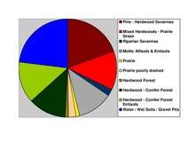
According to the U.S. Census Bureau, the county has a total area of 543 square miles (1,410 km2), of which 536 square miles (1,390 km2) is land and 7.0 square miles (18 km2) (1.3%) is water.[8] Wadena is one of 17 Minnesota counties with more savanna soils than prairie or forest soils.
Lakes
- Bill Lake - Blueberry Township
- Blueberry Lake - Blueberry Township
- Burgen Lake - Huntersville Township
- Duck Lake - southeast edge in Huntersville Township, southwest edge in Shell River Township
- Finn Lake - Shell River Township
- Granning Lake - Lyons Township
- Jim Cook Lake - Shell River Township
- Lily Lake - north quarter in Lyons Township, south three-quarters in Bullard Township
- Lovejoy Lake - Thomastown Township
- Lower Twin Lake - east half in Shell River Township, west half in Blueberry Township
- Mud Lake - Meadow Township
- Radabaugh Lake - Thomastown Township
- Rice Lake - Meadow Township
- Round Lake - Huntersville Township
- Simon Lake - Thomastown Township
- Spirit Lake - Menahga
- Stocking Lake - Blueberry Township
- Strike Lake - Lyons Township
- Thomas Lake - Blueberry Township
- Upper Twin Lake - south edge in Shell River Township
- Yaeger Lake - Meadow Township
Major highways
 U.S. Route 10
 U.S. Route 71
 Minnesota State Highway 29
 Minnesota State Highway 87
 Minnesota State Highway 227
Adjacent counties
- Hubbard County (north)
- Cass County (east)
- Todd County (south)
- Otter Tail County (southwest)
- Becker County (northwest)
Demographics
| Historical population | |||
|---|---|---|---|
| Census | Pop. | %± | |
| 1870 | 6 | — | |
| 1880 | 2,080 | 34,566.7% | |
| 1890 | 4,058 | 95.1% | |
| 1900 | 7,921 | 95.2% | |
| 1910 | 8,652 | 9.2% | |
| 1920 | 10,699 | 23.7% | |
| 1930 | 10,990 | 2.7% | |
| 1940 | 12,772 | 16.2% | |
| 1950 | 12,806 | 0.3% | |
| 1960 | 12,199 | −4.7% | |
| 1970 | 12,412 | 1.7% | |
| 1980 | 14,192 | 14.3% | |
| 1990 | 13,154 | −7.3% | |
| 2000 | 13,713 | 4.2% | |
| 2010 | 13,843 | 0.9% | |
| Est. 2015 | 13,875 | [9] | 0.2% |
| U.S. Decennial Census[10] 1790-1960[11] 1900-1990[12] 1990-2000[13] 2010-2015[3] | |||
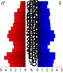
As of the census[14] of 2000, there were 13,713 people, 5,426 households, and 3,608 families residing in the county. The population density was 26 people per square mile (10/km²). There were 6,334 housing units at an average density of 12 per square mile (5/km²). The racial makeup of the county was 97.89% White, 0.48% Black or African American, 0.55% Native American, 0.18% Asian, 0.03% Pacific Islander, 0.27% from other races, and 0.59% from two or more races. 0.93% of the population were Hispanic or Latino of any race. 37.5% were of German, 14.0% Norwegian, 12.5% Finnish, 9.0% United States or American and 5.3% Swedish ancestry.
There were 5,426 households out of which 30.00% had children under the age of 18 living with them, 55.30% were married couples living together, 7.60% had a female householder with no husband present, and 33.50% were non-families. 29.20% of all households were made up of individuals and 15.10% had someone living alone who was 65 years of age or older. The average household size was 2.45 and the average family size was 3.02.
In the county the population was spread out with 25.80% under the age of 18, 8.10% from 18 to 24, 23.60% from 25 to 44, 22.60% from 45 to 64, and 19.90% who were 65 years of age or older. The median age was 40 years. For every 100 females there were 97.90 males. For every 100 females age 18 and over, there were 94.90 males.
The median income for a household in the county was $30,651, and the median income for a family was $38,618. Males had a median income of $28,424 versus $21,027 for females. The per capita income for the county was $15,146. About 9.70% of families and 14.10% of the population were below the poverty line, including 15.40% of those under age 18 and 12.60% of those age 65 or over.
Communities
Cities
- Aldrich
- Menahga
- Nimrod
- Sebeka
- Staples (partly in Todd County)
- Verndale
- Wadena (county seat; partly in Otter Tail County)
Townships
Unincorporated communities
See also
References
- ↑ "Minnesota Place Names". Minnesota Historical Society. Retrieved March 19, 2014.
- ↑ Upham, Warren (1920). Minnesota Geographic Names: Their Origin and Historic Significance. Minnesota Historical Society. p. 560.
- 1 2 "State & County QuickFacts". United States Census Bureau. Retrieved September 1, 2013.
- ↑ "Find a County". National Association of Counties. Retrieved 2011-06-07.
- ↑ http://wadenacountyhistory.org/county-origin/
- ↑ Nelson, Steven (2011). Savanna Soils of Minnesota. Minnesota: Self. pp. 53-56. ISBN 978-0-615-50320-2.
- ↑ Wadena County Historical Society
- ↑ "2010 Census Gazetteer Files". United States Census Bureau. August 22, 2012. Retrieved October 25, 2014.
- ↑ "County Totals Dataset: Population, Population Change and Estimated Components of Population Change: April 1, 2010 to July 1, 2015". Retrieved July 2, 2016.
- ↑ "U.S. Decennial Census". United States Census Bureau. Retrieved October 25, 2014.
- ↑ "Historical Census Browser". University of Virginia Library. Retrieved October 25, 2014.
- ↑ "Population of Counties by Decennial Census: 1900 to 1990". United States Census Bureau. Retrieved October 25, 2014.
- ↑ "Census 2000 PHC-T-4. Ranking Tables for Counties: 1990 and 2000" (PDF). United States Census Bureau. Retrieved October 25, 2014.
- ↑ "American FactFinder". United States Census Bureau. Retrieved 2008-01-31.
External links
 |
Becker County | Hubbard County | | |
| |
Cass County | |||
| ||||
| | ||||
| Otter Tail County | Todd County |
Municipalities and communities of Wadena County, Minnesota, United States | ||
|---|---|---|
| Cities | | |
| Townships | ||
| Unincorporated communities | ||
| Ghost towns | ||
| Footnotes | ‡This populated place also has portions in an adjacent county or counties | |
Coordinates: 46°35′N 94°58′W / 46.58°N 94.96°W