Indian Wells, California
| City of Indian Wells | |
|---|---|
| City | |
|
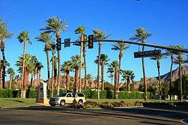
City limit as seen from Palm Desert, California | |
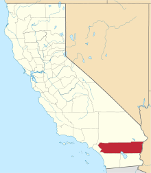
 Location in Riverside County and the state of California | |
 City of Indian Wells Location in the United States | |
| Coordinates: 33°43′07″N 116°18′30″W / 33.71861°N 116.30833°WCoordinates: 33°43′07″N 116°18′30″W / 33.71861°N 116.30833°W[1] | |
| Country | United States |
| State | California |
| County | Riverside |
| Incorporated | July 14, 1967[2] |
| Government | |
| • Mayor | Ty Peabody[3] |
| Area[4] | |
| • Total | 14.591 sq mi (37.790 km2) |
| • Land | 14.321 sq mi (37.091 km2) |
| • Water | 0.270 sq mi (0.699 km2) 1.85% |
| Elevation[1] | 89 ft (27 m) |
| Population (April 1, 2010)[5] | |
| • Total | 4,958 |
| • Estimate (2013)[5] | 5,165 |
| • Density | 340/sq mi (130/km2) |
| Time zone | Pacific (UTC−8) |
| • Summer (DST) | PDT (UTC−7) |
| ZIP code | 92210 |
| Area codes | 442/760 |
| FIPS code | 06-36434 |
| GNIS feature IDs | 1660797, 2410100 |
| Website |
cityofindianwells |
Indian Wells is a city in Riverside County, California, in the Coachella Valley. Incorporated in 1967, it lies in between Palm Desert and the resort town of La Quinta. As of the 2013 census, the city population was 5,165.
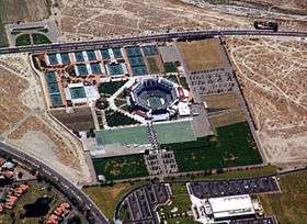
The city hosts the fifth-largest tennis tournament in the world, the Indian Wells Masters tennis tournament—presently known as the BNP Paribas Open. The Indian Wells Masters is one of nine ATP World Tour Masters 1000 high-level events operated by the Association of Tennis Professionals, and one of the four WTA Premier Mandatory tournaments of the Women's Tennis Association. It is held at the Indian Wells Tennis Garden, which contains the second-largest tennis-specific stadium in the world.
History
As early as 1853, the area now known as Indian Wells was the site of a thriving Indian village, as reported by W.P. Blade, a Smithsonian Institution geologist. A decade later, when gold was discovered on the Colorado River, William D. Bradshaw built a trail from Los Angeles through the desert to the gold mines. The Alexander and Company Stage Line used the trail to transport prospectors and Indian Wells became an important stop along the trail. Competition from the Southern Pacific Railroad caused the route to be abandoned briefly in 1875 before being reactivated by the Wells Fargo Company the following year.[6]
Over the next decades, settlers gradually arrived in the area and date palm ranches became profitable. The area's first golf courses were opened in the 1950s at the Eldorado Country Club and the Indian Wells Country Club. In 1957, Desi Arnaz opened his Indian Wells Hotel (forerunner to the Indian Wells Resort Hotel). In 1960, Arnold Palmer won the first Bob Hope Desert Classic golf tournament. President Dwight D. Eisenhower was a regular Indian Wells visitor and later an Eldorado homeowner.[7]
In an election held June 27, 1967, to avoid being annexed by neighboring cities such as Palm Desert, the inhabitants of Indian Wells voted to incorporate as a city. On July 14, 1967, Indian Wells became California's 400th city and the 16th in Riverside County. Since then, Indian Wells has continued to grow, with the development of resort hotels, golf courses and luxury residential areas.[8]
Demographics
| Historical population | |||
|---|---|---|---|
| Census | Pop. | %± | |
| 1970 | 760 | — | |
| 1980 | 1,394 | 83.4% | |
| 1990 | 2,647 | 89.9% | |
| 2000 | 3,816 | 44.2% | |
| 2010 | 4,958 | 29.9% | |
| Est. 2015 | 5,289 | [9] | 6.7% |
2010
The 2010 United States Census[11] reported that Indian Wells had a population of 4,958. The population density was 339.8 people per square mile (131.2/km²). The racial makeup of Indian Wells was 4,721 (95.2%) White (92.3% Non-Hispanic White),[12] 29 (0.6%) African American, 20 (0.4%) Native American, 83 (1.7%) Asian, 2 (0.0%) Pacific Islander, 52 (1.0%) from other races, and 51 (1.0%) from two or more races. Hispanic or Latino of any race were 209 persons (4.2%).
The Census reported that 4,952 people (99.9% of the population) lived in households, 6 (0.1%) lived in non-institutionalized group quarters, and 0 (0%) were institutionalized.
There were 2,745 households, out of which 193 (7.0%) had children under the age of 18 living in them, 1,519 (55.3%) were opposite-sex married couples living together, 85 (3.1%) had a female householder with no husband present, 46 (1.7%) had a male householder with no wife present. There were 85 (3.1%) unmarried opposite-sex partnerships, and 36 (1.3%) same-sex married couples or partnerships. 944 households (34.4%) were made up of individuals and 690 (25.1%) had someone living alone who was 65 years of age or older. The average household size was 1.80. There were 1,650 families (60.1% of all households); the average family size was 2.22.
The age distribution was: 310 people (6.3%) under the age of 18, 76 people (1.5%) aged 18 to 24, 283 people (5.7%) aged 25 to 44, 1,558 people (31.4%) aged 45 to 64, and 2,731 people (55.1%) who were 65 years of age or older. The median age was 66.7 years. For every 100 females there were 84.6 males. For every 100 females age 18 and over, there were 84.2 males.
There were 5,137 housing units at an average density of 352.1 per square mile (135.9/km²), of which 2,285 (83.2%) were owner-occupied, and 460 (16.8%) were occupied by renters. The homeowner vacancy rate was 5.1%; the rental vacancy rate was 15.4%. 4,251 people (85.7% of the population) lived in owner-occupied housing units and 701 people (14.1%) lived in rental housing units.
During 2009–2013, Indian Wells had a median household income of $83,884, with 5.2% of the population living below the federal poverty line.[5]
2000
As of the census[13] of 2000, there were 3,816 people, 1,982 households, and 1,323 families residing in the city. The population density was 288.5 people per square mile (111.4/km²). There were 3,843 housing units at an average density of 290.5 per square mile (112.2/km²). The racial makeup of the city was 96.3% White, 1.5% Asian, 0.4% Black or African American, 0.2% Native American, 0.1% Pacific Islander, 0.5% from other races, and 1.0% from two or more races. 3.0% of the population were Hispanic or Latino of any race.
There were 1,982 households out of which 8.4% had children under the age of 18 living with them, 63.1% were married couples living together, 3.0% had a female householder with no husband present, and 33.2% were non-families. 28.4% of all households were made up of individuals and 17.6% had someone living alone who was 65 years of age or older. The average household size was 1.9 and the average family size was 2.3.
The age distribution is 7.6% under the age of 18, 1.5% from 18 to 24, 9.4% from 25 to 44, 35.3% from 45 to 64, and 46.2% who were 65 years of age or older. The median age was 63 years. For every 100 females there were 89.5 males. For every 100 females age 18 and over, there were 89.3 males.
The median income for a household in the city was $93,986, and the median income for a family was $119,110. Males had a median income of $88,709 versus $49,539 for females. The per capita income for the city was $76,187. About 1.2% of families and 3.4% of the population were below the poverty line, including none of those under age 18 and 2.6% of those age 65 or over.
Geography
Indian Wells is located at 33°42′57″N 116°20′28″W / 33.71583°N 116.34111°W (33.715755, −116.341109).[14]
According to the United States Census Bureau, the city has a total area of 14.6 square miles (38 km2), of which, 14.3 square miles (37 km2) of it is land and 0.3 square miles (0.78 km2) of it (1.85%) is water.
Climate
This climate is dominated in all months by the subtropical anticyclone, or subtropical high, with its descending air, elevated inversions, and clear skies. Such an atmospheric environment inhibits precipitation.[15]
| Climate data for Indio, California (approximately 8 miles east of Indian Wells) (1981–2010 normals) | |||||||||||||
|---|---|---|---|---|---|---|---|---|---|---|---|---|---|
| Month | Jan | Feb | Mar | Apr | May | Jun | Jul | Aug | Sep | Oct | Nov | Dec | Year |
| Record high °F (°C) | 95 (35) |
99 (37) |
104 (40) |
112 (44) |
116 (47) |
121 (49) |
123 (51) |
123 (51) |
121 (49) |
116 (47) |
102 (39) |
93 (34) |
123 (51) |
| Average high °F (°C) | 70.7 (21.5) |
73.9 (23.3) |
80.5 (26.9) |
87.5 (30.8) |
95.6 (35.3) |
103.6 (39.8) |
108.1 (42.3) |
107.3 (41.8) |
101.7 (38.7) |
91.1 (32.8) |
78.4 (25.8) |
69.3 (20.7) |
89.0 (31.7) |
| Average low °F (°C) | 45.5 (7.5) |
48.0 (8.9) |
52.2 (11.2) |
57.4 (14.1) |
64.4 (18) |
71.0 (21.7) |
77.6 (25.3) |
77.6 (25.3) |
71.7 (22.1) |
62.5 (16.9) |
51.8 (11) |
44.2 (6.8) |
60.3 (15.7) |
| Record low °F (°C) | 19 (−7) |
24 (−4) |
29 (−2) |
34 (1) |
36 (2) |
44 (7) |
54 (12) |
52 (11) |
46 (8) |
30 (−1) |
23 (−5) |
23 (−5) |
19 (−7) |
| Average precipitation inches (mm) | 1.15 (29.2) |
1.11 (28.2) |
0.53 (13.5) |
0.06 (1.5) |
0.02 (0.5) |
0.02 (0.5) |
0.13 (3.3) |
0.29 (7.4) |
0.23 (5.8) |
0.24 (6.1) |
0.32 (8.1) |
0.87 (22.1) |
4.97 (126.2) |
| Average precipitation days (≥ 0.01 in) | 3.1 | 3.2 | 1.6 | 0.6 | 0.2 | 0 | 0.6 | 0.9 | 0.8 | 0.7 | 0.8 | 1.9 | 14.4 |
| Source: NOAA [16] | |||||||||||||
Politics
Indian Wells has the second highest percentage of registered Republicans of any city in California, with 65.1% of its 3,027 registered voters registered as Republicans, 19.5% of voters are registered Democrats, and 12.2% declined to state.[17]
In the California State Legislature, Indian Wells is in the 28th Senate District, represented by Republican Jeff Stone, and in the 42nd Assembly District, represented by Republican Chad Mayes.[18]
In the United States House of Representatives, Indian Wells is in California's 36th congressional district, represented by Democrat Raul Ruiz.[19]
Notable residents
- Desi Arnaz – singer, actor and developer[20]
- Robert "Bob" Cummings - actor
- Ernest E. Debs – Los Angeles City Council member and Los Angeles County supervisor
- Dwight D. Eisenhower - former U.S. President and avid golfer
- Don Fairfield – golfer
- Howard Haugerud - military pilot, diplomat, businessman and educator
- Colleen Kay Hutchins – former Miss America
- Richard M. Jennings – U.S. Army officer, author and businessman
- Jack Jones – singer
- Robert Kardashian – lawyer
- Arthur Lake – actor
- W. Howard Lester – businessman
- Cargill MacMillan Jr – businessman[21]
- Charles Peebler – advertising executive
- Robert Prescott - Founder of the Flying Tiger Line
- Charles H. Price II – businessman and former ambassador
- Tommy Shepard – trombonist and orchestra leader
- Ernie Vandeweghe – physician, U.S. Air Force veteran and basketball player; husband of Colleen Kay Hutchins
- Sam B. Williams – inventor and businessman
- John Wilson – golfer
Notes and references
- 1 2 "Indian Wells". Geographic Names Information System. United States Geological Survey. Retrieved November 11, 2014.
- ↑ "California Cities by Incorporation Date" (Word). California Association of Local Agency Formation Commissions. Retrieved August 25, 2014.
- ↑ "Mayor Ty Peabody". City of Indian Wells. Retrieved January 23, 2015.
- ↑ "2010 Census U.S. Gazetteer Files – Places – California". United States Census Bureau.
- 1 2 3 "Indian Wells (city) QuickFacts". United States Census Bureau. Retrieved March 19, 2015.
- ↑ City of Indian Wells – The Early Years
- ↑ City of Indian Wells – The 1950s & 1960s
- ↑ City of Indian Wells – Becoming A City
- ↑ "Annual Estimates of the Resident Population for Incorporated Places: April 1, 2010 to July 1, 2015". Retrieved July 2, 2016.
- ↑ "Census of Population and Housing". Census.gov. Archived from the original on May 11, 2015. Retrieved June 4, 2015.
- ↑ "2010 Census Interactive Population Search: CA - Indian Wells city". U.S. Census Bureau. Retrieved July 12, 2014.
- ↑ http://factfinder2.census.gov/faces/tableservices/jsf/pages/productview.xhtml?pid=DEC_10_DP_DPDP1. Missing or empty
|title=(help) - ↑ "American FactFinder". United States Census Bureau. Archived from the original on September 11, 2013. Retrieved 2008-01-31.
- ↑ "US Gazetteer files: 2010, 2000, and 1990". United States Census Bureau. 2011-02-12. Retrieved 2011-04-23.
- ↑ http://www.weatherbase.com/weather/weather.php3?s=952440&cityname=Indio-California
- ↑ "NowData – NOAA Online Weather Data". National Oceanic and Atmospheric Administration. Retrieved 2012-04-17.
- ↑ "Archived copy" (PDF). Archived from the original (PDF) on July 1, 2014. Retrieved December 16, 2009.
- ↑ "Statewide Database". UC Regents. Retrieved November 23, 2014.
- ↑ "California's 36th Congressional District - Representatives & District Map". Civic Impulse, LLC.
- ↑ Meeks, Eric G. (2011). P.S. I Love Lucy: The Story of Lucille Ball in Palm Springs. Horatio Limburger Oglethorpe. p. 26. ISBN 978-1468098549.
- ↑ "Obituary: Cargill MacMillan, 84, company heir". StarTribune. Retrieved 20 November 2014.
External links
| Wikivoyage has a travel guide for Indian Wells. |
 |
Palm Desert | Palm Desert | Bermuda Dunes | |
| Palm Desert | |
La Quinta | ||
| ||||
| | ||||
| Santa Rosa Mountains | Santa Rosa Mountains | La Quinta |