Interstate 22
| |||||||
|---|---|---|---|---|---|---|---|
|
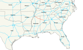
Interstate 22 highlighted in red. | |||||||
| Route information | |||||||
| Length: | 213.0 mi[1] (342.8 km) | ||||||
| Existed: | 2012[2] – present | ||||||
| Major junctions | |||||||
| West end: |
| ||||||
| |||||||
| East end: |
| ||||||
| Location | |||||||
| States: | Mississippi, Alabama | ||||||
| Highway system | |||||||
| |||||||

Interstate 22 (I-22) is an Interstate Highway that follows the U.S. Route 78 (US 78) corridor on a 213-mile-long (343 km) route from Byhalia, Mississippi south of Memphis, Tennessee, to Birmingham, Alabama.[1] I-22 indirectly connects I-240, I-40, I-55, and I-69 in the northwest with I-65 and I-20/I-59 in the southeast. When designated in 2012, it was designed to close a gap in the Interstate network allowing more direct connections between cities in the southeast (such as Atlanta and Birmingham) with those of the Great Plains (such as Oklahoma City and St. Louis).
Along its way through the two states, I-22 serves the towns of Jasper, Winfield, and Hamilton, Alabama and Fulton, Tupelo, New Albany, and Holly Springs, Mississippi. All portions of this highway were either built new or converted to Interstate Highway standards as of early 2011. A future interchange with I-269 near Byhalia, Mississippi is the western terminus of I-22. The eastern terminus is at an interchange with I-65 in Jefferson County, north of Birmingham.
History
The concept of a Memphis-to-Birmingham expressway was discussed as early as the 1950s, but did not move beyond talk for more than 20 years.[3]
The part of I-22 just east of Fulton, Mississippi, was approved by Congress as "Corridor X" in 1978, as a part of the Appalachian Development Highway System, and parts of I-22 have been under construction ever since.[4] Corridor X was also designated as "High Priority Corridor 10" in the Federal National Highway System Designation Act of 1995, and as "High Priority Corridor 45" in later legislation.[5] Over the many years of development, the project changed multiple times.
In 2004, Corridor X was designated as Future I-22 by Public Law Number 108-199,[6] and the designation was made official on April 18, 2005.[7] In Alabama and Mississippi, blue signs reading "FUTURE/I-22/CORRIDOR" at left and an I-22 shield with "FUTURE" instead of "INTERSTATE" at the right were unveiled on April 18, 2005.[7]
Route description
I-22 now covers nearly the full distance between Birmingham and suburban Memphis, with the interchange at I-65 in Birmingham, Alabama. In Mississippi, I-22 runs from the Alabama state line across the state to I-269, the Memphis outer beltway, near Byhalia. This is about twelve miles (19 km) short of the Memphis city limits. While I-22 itself does not continue past I-269 to Memphis, some theorize that an I-22 spur route may be named along the existing US 78 from I-269 northward to the Tennessee state line, creating a better connection between Memphis and I-22.
U.S. Highway 78
Future I-22 is part of the longer US 78. Nearly all of US 78 today has been moved from its original roadway from Graysville, Alabama, through to Memphis. The fate of US 78 once Corridor X officially becomes I-22 is still undecided. Its original highway between Graysville and Memphis now bears several different state highway designations. From Graysville to Jasper, it is called State Route 5 (SR 5). For a short stretch in western Jasper, it is designated as SR 69, but once it turns south in western Jasper, the highway becomes SR 118. This remains its designation until it reaches Winfield, where it becomes US 43, and at Guin, US 278 joins the highway. This continues through the town of Hamilton. In Hamilton, the former route of US 78 becomes SR 74 westward to its intersection with I-22 at exit 7. From that exit though the Mississippi state line, the current US 78 and Future I-22 are the same highway. (Here, the new I-22 has been built on top of the old US 78.)
At the Mississippi state line, travelers can look to the north to see the old US 78. This is still used today as a local road, but it is not accessible from Corridor X. At exit 113 on Corridor X, the old highway is accessible via Mississippi Highway 23 (MS 23) just north of Corridor X, and westbound from there it is MS 178.
MS 178 continues into Fulton, Miss. At Fulton, due to the existence of the Tennessee Tombigbee Waterway, the original highway no longer exists just west of downtown Fulton. Then it can be entered again via I-22 at exit 101 as MS 178 again. The old highway (as MS 178) continues to run parallel with and south of I-22 into and past the town of Tupelo where it crosses Corridor X again at exit 81. The original routing remains parallel to and north of Corridor X through Sherman, Blue Springs, New Albany, Myrtle, and Hickory Flat before crossing Corridor X again at exit 48. It now runs parallel to and south of Corridor X through Potts Camp before crossing Corridor X the last time between Potts Camp and Lake Center and then it continues into Holly Springs, Red Banks, Victoria, Byhalia, and finally through Olive Branch. The decision to be made by the three departments of transportation is to whether to decommission US 78 from Birmingham all the way to downtown Memphis; or to redesignate the former US 78 routing once again as US 78; or to have I-22 also designated as US 78 on its entire distance between Birmingham and Metro Memphis. There has been no indication as of January 2011 as to when such a decision might be made.
Mississippi
While it was originally stated that I-22 would continue all of the way to the Tennessee state line, the decision was made to have I-22 terminate at the I-269 interchange near Byhalia. Another theory took I-22 along I-269 to I-55/I-69, but those plans also never materialized. However, I-269 and US 78 from I-269 northward to Memphis will create indirect connections to all Memphis-area interstates.
Because US 78's exits and mile posts in Mississippi currently start at the Tennessee state line, there is a discrepancy between the mile posts of I-22 and the exit numbers. It is assumed that MDOT will re-number the exits to match I-22's terminus at I-269.
Mississippi officials announced May 5, 2015 that the state officially began the process to designate its portion as I-22. The two requirements to be able to apply for this designation were to upgrade the route to interstate standards (as noted above) and to connect to an existing interstate within 25 years; this will be completed once I-269 is opened within the next couple years and the I-65 interchange is completed within the year.[8] The route will be officially signed in Mississippi in a ceremony taking place on October 23, 2015.[9]
Roadway lighting is in place at the following Mississippi exits: 2 (Olive Branch), 26 and 30 (Holly Springs), 61 (New Albany), 86 (Tupelo), and 104 (Fulton). Roadway lighting is also installed as of August 2010 at exits 73 and 76 (Blue Springs and Sherman) which provide access to the Toyota automotive facility.
Mississippi also has currently one welcome center for westbound travelers approximately two miles (3.2 km) from the Alabama state line.[10] There is also a truck weigh station near Fulton.
Alabama

Approximately 95 miles (153 km) of I-22 is open to traffic in Alabama. The first major completed section of the route between the Mississippi state line and Jasper was opened to traffic on November 22, 2005.[11] Exits on the Jasper Bypass portion of I-22 were originally numbered using a kilometer-based sequence because at the time this stretch was opened it appeared that all highways in the U.S. were going to be measured using the metric system. The final decision was made to remain using miles, and they have been renumbered according to the highway's mileposts. A six-mile (9.7 km) segment between Graysville and Brookside was opened in June 2007,[12] and another 20-mile (32 km) section of Future I-22 between Jasper and Graysville was opened in November 2007.[13] A 1.8-mile (2.9 km) segment between Cherry Avenue in Forestdale to a point about 2.5 miles (4.0 km) short of I-65 near Fultondale, including an interchange with Coalburg Road, was opened in December 2009.[14] Next came the connection of I-22 with I-65 and US 31.[14] The Alabama Department of Transportation (ALDOT) widened Coalburg Road from its interchange with I-22 southward to Daniel Payne Drive (which leads to I-65) to allow heavy trucks to use it; this project was nearly complete as of May 2015.[15] Signs are now in place on Daniel Payne Drive (westbound) informing truckers that access to I-22 is not allowed from Daniel Payne Drive.
I-22 was planned to be completed in October 2014, with the 14-bridge stack interchange in Birmingham.[16] Construction to widen I-65 to four lanes in both directions began from just south of the upcoming highway interchange southward to the 16th Street interchange in Birmingham. Under the present design, I-22 will terminate at I-65, but the highway will continue a short distance beyond I-65 as a long pair of ramps to US 31.[17] Another associated project is a widening of I-65 from its interchange with I-22 northward to the Walker Chapel Road exit.[18]
ALDOT was to award contracts in August 2009 for the construction of the final segment of I-22, including its large interchange with I-65 and US 31, with the construction to begin shortly afterwards. Funding delays postponed these into 2010, however. On March 19, 2010, President Barack Obama signed the HIRE (Hiring Incentives to Restore Employment) Act into law, which included an extension of federal highway funding through the end of 2010. This extension gave the ALDOT the opportunity to proceed with its plans for the construction of final segment of I-22 in Alabama. The opening of the bids for this project began on May 21, 2010. ALDOT announced on June 16, 2010, that the project has been awarded to the company Archer Western Contractors for $168.6 million.[19] The project is the most expensive highway project ever undertaken in Jefferson County, and it is the highest-priced contract awarded by the ALDOT as of 2010.[16]
Various lighting projects have been completed along I-22 since 2008. These include lighting at exits 85, 30, and 14. I-22 is a six-lane highway between exit 63, at Jasper, and the current terminus of the highway at exit 93, at Coalburg Road. A stretch of I-22 between exits 57 and 52 is also six-lane freeway. ALDOT, as of July 2010, has no plans to construct an Alabama Welcome Center for eastbound travelers from Mississippi into Alabama.
Exit 53 is currently an unnamed exit. ALDOT stated that the original intent was for this interchange to serve as SR 102 and connect to the existing SR 102 at Townley. The mileage signs on the interchange bridge facings indicate the route as SR 102 but ALDOT has stated that funds are not currently available to extend SR 102 from I-22 to the intersection of SR 124 and SR 102 at Townley. This unbuilt roadway is approximately five miles (8.0 km) long. As of summer 2011, this exit serves only as a connection to SR 118 (the old US 78) on the northside of I-22 and as a local road serving a few residences on the southside of I-22.
In April 2013, the first actual Interstate 22 shields were deployed in Marion County, Alabama, immediately east of the Mississippi state line. Such signage will extend east at least through Walker County into the outskirts of Birmingham.[20]
On August 21, 2014, ALDOT reported that I-22's interchange with I-65 would not be completed until October 2015.[21] The interchange's connections via exit 95 to I-65 and the continuation over I-65 as exit 95C at US 31 remained under construction. In March 2016, the intersection with I-65 and continuation to US 31 was still under construction. New lanes north and south bound were opened on I-65 passing through the interchange and construction and painting operations were carried out on the I-22 entrance and exit ramps.[22] The interchange to I-65 opened to traffic on June 20, 2016, while the connector to US 31 remained under construction.[23]
Exit list
| State | County | Location | mi[1] | km | Exit | Destinations | Notes |
|---|---|---|---|---|---|---|---|
| Mississippi | DeSoto | | 0.0 | 0.0 | — | Continuation as US 78; western end of US 78 overlap | |
| Byhalia | 12 | Memphis Outer Beltway, currently under construction, will be exits 16A-B; to be numbered as exits 12A (south) and 12B (north).[24] | |||||
| Marshall | 2.4 | 3.9 | 14 | ||||
| | 6.6 | 10.6 | 18 | Victoria, East Byhalia | |||
| | 9.8 | 15.8 | 21 | Red Banks | |||
| Holly Springs | 14.4 | 23.2 | 26 | Access to Mount Pleasant via MS 311 north, MS 4 and MS 7 now bypass the downtown area of Holly Springs | |||
| 18.5 | 29.8 | 30 | Access to Senatobia via MS 7 | ||||
| | 25.5 | 41.0 | 37 | Lake Center | |||
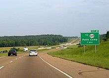
| Potts Camp | 29.6 | 47.6 | 41 | ||||
| Benton | Hickory Flat | 36.4 | 58.6 | 48 | Access to MS 2 and MS 5 | ||
| Union | Myrtle | 42.9 | 69.0 | 55 | Myrtle | ||
| New Albany | 48.6 | 78.2 | 60 | Glenfield | Connector to MS 30 and to a Wal-Mart distribution center | ||
| 49.6 | 79.8 | 61 | West end of MS 30 overlap | ||||
| 51.0 | 82.1 | 63 | Downtown New Albany | ||||
| 64 | East end of MS 30 overlap | ||||||
| 61.2 | 98.5 | 73 | West end of MS 9 overlap and service to a new Toyota plant; Signed as exits 73A and 73B | ||||
| Pontotoc | Sherman | 64.8 | 104.3 | 76 | East end of MS 9 overlap and accesses the new Toyota plant | ||
| Lee | Tupelo | 69.0 | 111.0 | 81 | |||
| 70.3 | 113.1 | 82 | Coley Road / Barnes Crossing Road | ||||
| 72.9 | 117.3 | 85 | |||||
| 74.3 | 119.6 | 86 | West end of Corridor V overlap; signed as exits 86A (south) and 86B (north) | ||||
| 75.8 | 122.0 | 87 | Veterans Boulevard | Access to Elvis Presley birthplace | |||
| | 78.1 | 125.7 | 90 | Auburn Road | |||
| | 82.2 | 132.3 | 94 | ||||
| Itawamba | | 85.3 | 137.3 | 97 | Fawn Grove Road – Dorsey | ||
| | 88.8 | 142.9 | 101 | Due to the Tenn-Tom waterway, MS 178 ends on the west bank of the waterway opposite Fulton | |||
| Fulton | 92.9 | 149.5 | 104 | West end of MS 25 overlap, MS 178 resumes eastbound in downtown Fulton | |||
| | 96.6 | 155.5 | 108 | Corridor X ends | East end of MS 25/Corridor V overlap; west end of Corridor X overlap | ||
| Tremont | 101.4 | 163.2 | 113 | MS 178 terminates eastbound at intersection with MS 23 just north of Corridor X | |||
| 106.0 0.0 | 170.6 0.0 | Mississippi–Alabama state line | |||||
| Alabama | Marion | | 3.9 | 6.3 | 3 | ||
| Hamilton | 7.8 | 12.6 | 7 | Provides access to US-278 east and to SR 19 Red Bay | |||
| 11.4 | 18.3 | 11 | Also connects to SR 19 | ||||
| 14.4 | 23.2 | 14 | |||||
| 16.9 | 27.2 | 16 | |||||
| | 22.5 | 36.2 | 22 | ||||
| | 26.2 | 42.2 | 26 | Also serves the community of Twin | |||
| Winfield | 29.9 | 48.1 | 30 | ||||
| | 34.3 | 55.2 | 34 | ||||
| Walker | | 39.6 | 63.7 | 39 | Also access to Fayette and Tuscaloosa via SR 13 south | ||
| Carbon Hill | 46.8 | 75.3 | 46 | ||||
| | 51.7 | 83.2 | 52 | ||||
| | 53.4 | 85.9 | 53 | (no name) | Proposed SR 102; exit number not signed | ||
| Jasper | 57.3 | 92.2 | 57 | ||||
| 60.4 | 97.2 | 61 | Old exit 96 | ||||
| 62.6 | 100.7 | 63 | Old exit 101 | ||||
| 65.1 | 104.8 | 65 | Industrial Parkway – Jasper | Old exit 104 | |||
| | 69.9 | 112.5 | 70 | ||||
| | 71.9 | 115.7 | 72 | ||||
| | 78.2 | 125.9 | 78 | ||||
| Jefferson | West Jefferson | 81.0 | 130.4 | 81 | Alabama Power Miller Steam Plant access (coal fired electric power plant) | ||
| Graysville | 85.0 | 136.8 | 85 | Eastern end of US 78 Overlap | |||
| 86.00 | 138.40 | 86 | Proposed interchange; proposed southern terminus of I-222 | ||||
| 87.1 | 140.2 | 87 | |||||
| Forestdale | 88.9 | 143.1 | 89 | ||||
| 91.6 | 147.4 | 91 | |||||
| Birmingham | 93.1 | 149.8 | 93 | Directional signs on exit ramp north to Coalburg and south to Birmingham | |||
| 95 | I-65 exit 265A; signed as exits 95A (north) and 95B (south) | ||||||
| 95C | Under construction; future eastern terminus | ||||||
1.000 mi = 1.609 km; 1.000 km = 0.621 mi
| |||||||
Auxiliary routes
U.S. Congressman Spencer Bachus announced in The Birmingham News in May 2009 that the proposed Northern Beltline had been numbered as I-422.[25] This Interstate Highway should intersect with I-22 near Graysville, and then continue southwest to connect with I-20/I-59, and also from I-22 eastward to connect with I-59 near Argo.[25]
The plans for this highway call for a short spur from I-22, near mile marker 86, northward to connect with I-422. This spur has been dubbed I-222. I-422 would pass over I-22 just west of Graysville without an interchange there. Drivers on I-22 would need to use I-222 to transit from I-22 to I-422 under this current plan.
Related routes
| |
|---|---|
| Location: | Birmingham, Ala. |
| Length: | 2.26 mi (3.64 km) |
Interstate 222 (I-222) is a future Auxiliary Interstate Highway to be a connector between I-22/US-78 and the proposed I-422 near Birmingham, Alabama. Like I-189, I-381, Portland, ME's iteration of I-495, I-587 and I-865, there will be no exits other than its termini.
The highways has been proposed because workers can not build an interchange directly between I-22 and I-422. The interchange cannot be built because of environmental issues. The Interstate lineup was approved May 18, 2012. The Interstate is not planned to be built until 2026 when I-422 is built.
See also
 Alabama portal
 Mississippi portal
 U.S. Roads portal
References
- 1 2 3 Google (September 23, 2014). "Interstate 22" (Map). Google Maps. Google. Retrieved September 23, 2014.
- ↑ Vitale, Marty (November 16, 2012). "SCOH Report from Special Committee on U.S. Route Numbering Annual Meeting" (PDF) (Report). Pittsburgh, PA: American Association of State Highway and Transportation Officials. p. 2. Retrieved September 23, 2014.
- ↑ "Lynchpin I-22 Nears Completion". Business Alabama. October 2015. Retrieved February 20, 2016.
- ↑ McMurray, Jeffery (December 22, 2003). "Shelby's Clout Has Helped Put Corridor X on the Brink of Completion". Associated Press State and Local Wire.
- ↑ "Future I-22". Interstate-guide.com. Retrieved February 15, 2008.
- ↑ MacDonald, Ginny (January 28, 2004). "Corridor X Gets Official Seal as I-22". The Birmingham News.
- 1 2 MacDonald, Ginny (April 15, 2005). "Corridor X Becomes I-22: Signs Bearing Name to Be Unveiled Monday in Jasper by Officials". The Birmingham News. p. 1C.
- ↑ "Interstate 22 Designation Moving Nearer". Northeast Mississippi Daily Journal.
- ↑ "Mississippi Ceremony Will Designate US 78 as I-22". Memphis Commercial Appeal. Retrieved October 18, 2015.
- ↑ "Rest Areas and Welcome Centers". Mississippi Department of Transportation. Retrieved July 8, 2010.
- ↑ Faulk, Kent (November 23, 2005). "Corridor X Section Opens in West Alabama". The Birmingham News. p. 4C.
- ↑ MacDonald, Ginny (June 2, 2007). "13 Miles of Corridor X to Open: End of Long Road in Sight for I-22". The Birmingham News. p. 1A.
- ↑ MacDonald, Ginny (October 31, 2007). "26 Miles of Corridor X to Open Nov. 14: Stretch Offers Straight Shot from Forestdale to Memphis". The Birmingham News. p. 1A.
- 1 2 Staff Reporters (December 10, 2009). "Corridor X Opens New Section: Interchange Lags". The Birmingham News. p. 2A.
- ↑ "Coalburg Road Looks Nice and Smooth, but Not Done ... Yet". AL.com. May 10, 2015.
- 1 2 Gray, Jeremy (July 26, 2010). "Birmingham I-65/Corridor X Project Set to Launch August 1". The Birmingham News. Retrieved July 26, 2010.
- ↑ MacDonald, Ginny (November 26, 2006). "Roads Chief Wants I-22 Done by 2010: Corridor X Connection and I-65 Widening to Begin Next Year". The Birmingham News. p. 1A.
- ↑ Gray, Jeremy (May 21, 2010). "Alabama Department of Transportation Opens Bids on Corridor X Link to Interstate 65". The Birmingham News. Retrieved May 22, 2010.
- ↑ Gray, Jeremy (June 16, 2010). "Construction Contract Awarded for Final Link of Corridor X". The Birmingham News. Retrieved June 21, 2010.
- ↑ "Interstate 22 Signs Going Up". Daily Mountain Eagle. Jasper, AL. April 4, 2013.
- ↑ "Interstate 22 Progress: I-65 Interchange with Corridor X Won't Be Completed Until at Least 2015". Birmingham Business Journal. August 22, 2014. Retrieved September 25, 2014.
- ↑ Songer, Joe (March 7, 2016). "I-22 Interchange Construction Continues at I-65 near Fultondale". AL.com. Retrieved March 15, 2016.
- ↑ Yeager, Andrew (June 20, 2016). "Interstate 22 Interchange Opens Completing Link to Memphis". Birmingham, AL: WBHM. Retrieved June 21, 2016.
- ↑ Mississippi Department of Transportation. "Proposal for Interstate 269" (PDF). Mississippi Department of Transportation. Retrieved July 12, 2016.
- 1 2 MacDonald, Ginny (May 26, 2009). "Corridor X/ I-65 Interchange Construction Could Begin This Year". The Birmingham News. Retrieved May 26, 2009.
External links
| Signed | |||||||||||
|---|---|---|---|---|---|---|---|---|---|---|---|
| Unsigned | |||||||||||
| Lists |
| ||||||||||
Major Interstates highlighted | |||||||||||
Roads of Memphis | |||||||||||
|---|---|---|---|---|---|---|---|---|---|---|---|
| Interstate Highways | 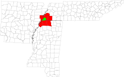 | ||||||||||
| U.S. Highways | |||||||||||
| State Highways |
| ||||||||||
| Other Highways | |||||||||||