Koloa, Hawaii
| Koloa, Hawaii | |
|---|---|
| Census-designated place | |
|
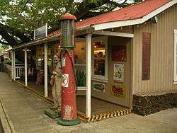
A shop in Kōloa | |
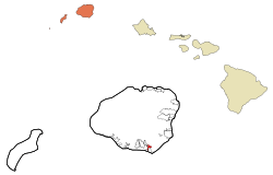 Location in Kauai County and the state of Hawaii | |
| Coordinates: 21°54′26″N 159°27′57″W / 21.90722°N 159.46583°WCoordinates: 21°54′26″N 159°27′57″W / 21.90722°N 159.46583°W | |
| Country | United States |
| State | Hawaii |
| County | Kauai |
| Area | |
| • Total | 1.2 sq mi (3.1 km2) |
| • Land | 1.2 sq mi (3.1 km2) |
| • Water | 0.0 sq mi (0.0 km2) |
| Elevation | 213 ft (65 m) |
| Population (2010) | |
| • Total | 2,144 |
| • Density | 1,786.6/sq mi (691.6/km2) |
| Time zone | Hawaii-Aleutian (UTC-10) |
| ZIP code | 96756 |
| Area code(s) | 808 |
| FIPS code | 15-39200 |
| GNIS feature ID | 0361395 |
Kōloa is a census-designated place (CDP) in Kauaʻi County, Hawaiʻi, United States. The population was 1,942 at the 2000 census. Kōloa is often incorrectly translated as native duck, which is the correct translation for the similar-looking koloa (without the macron).[1] Kōloa has no known translation.[2] According to one account, the district Kōloa was named for a steep rock called Pali-o-kō-loa which was found in 'Waikomo' stream. The first successful sugarcane plantation in the Islands was started here in 1835. It became a part of Grove Farm in 1948.
Geography
Kōloa is located at 21°54′26″N 159°27′57″W / 21.90722°N 159.46583°W (21.907137, -159.465877).[3]
According to the United States Census Bureau, the CDP has a total area of 1.2 square miles (3.1 km2), all of it land.
Demographics


As of the census[4] of 2000, there were 1,942 people, 693 households, and 507 families residing in the CDP. The population density was 1,629.5 people per square mile (630.1/km2). There were 748 housing units at an average density of 627.6 per square mile (242.7/km2). The racial makeup of the CDP was 20.2% White, 0.4% African American, 0.3% Native American, 43.8% Asian, 7.8% Pacific Islander, 1.2% from other races, and 26.4% from two or more races. Hispanic or Latino of any race were 11.4% of the population.
There were 693 households out of which 34.8% had children under the age of 18 living with them, 47.2% were married couples living together, 18.9% had a female householder with no husband present, and 26.8% were non-families. 22.5% of all households were made up of individuals and 8.7% had someone living alone who was 65 years of age or older. The average household size was 2.80 and the average family size was 3.25.
In the CDP the population was spread out with 26.0% under the age of 18, 9.9% from 18 to 24, 26.7% from 25 to 44, 21.6% from 45 to 64, and 15.8% who were 65 years of age or older. The median age was 36 years. For every 100 females there were 101.0 males. For every 100 females age 18 and over, there were 96.3 males.
The median income for a household in the CDP was $34,786, and the median income for a family was $43,393. Males had a median income of $31,125 versus $25,938 for females. The per capita income for the CDP was $16,224. About 16.7% of families and 17.8% of the population were below the poverty line, including 26.5% of those under age 18 and 6.0% of those age 65 or over.
History
The Old Sugar Mill of Koloa was the first major sugarcane plantation in Hawaii in 1835.[5] Missionary Daniel Dole and his family opened a boarding school for English language speaking children, sometimes called the Koloa Academy, in 1855.[6][7]
Places of interest
- Old Sugar Mill – A National Historic Landmark. Founded in 1835, the Koloa sugar plantation and mill was the first successful large-scale sugar operation in the Hawaiian Islands.[8]
- Poipu Bay Golf Course – Home of the PGA Grand Slam of Golf from 1994 to 2006[9][10]
- Saint Raphael Catholic Church - The oldest Catholic church in Kauai
Notable natives
References
- ↑ Mary Kawena Pukui and Elbert (2003). "lookup of koloa". on Hawaiian dictionary. Ulukau, the Hawaiian Electronic Library, University of Hawaii. Retrieved August 25, 2010.
- ↑ Mary Kawena Pukui and Elbert (2004). "lookup of Kōloa". on Place Names of Hawai'i. Ulukau, the Hawaiian Electronic Library, University of Hawaii. Retrieved September 7, 2010.
- ↑ "US Gazetteer files: 2010, 2000, and 1990". United States Census Bureau. 2011-02-12. Retrieved 2011-04-23.
- ↑ "American FactFinder". United States Census Bureau. Archived from the original on September 11, 2013. Retrieved 2008-01-31.
- ↑ Benjamin Levy (August 1978). "Old Sugar Mill of Koloa nomination form" (PDF). National Register of Historic Places. U.S. National Park Service. Retrieved September 7, 2010.
- ↑ Paul T. Burlin (2008). "Elias Bond and Daniel Dole". Imperial Maine and Hawai'i: Interpretative Essays in the History of Nineteenth Century American Expansion. Rowman & Littlefield. pp. 80–86. ISBN 978-0-7391-2718-6.
- ↑ "Inventory of the George H. Dole Papers, 1846-1902" (PDF). Online Archive of California. Huntington Library. 1998. Retrieved September 7, 2010.
- ↑ Old Sugar Mill of Koloa National Historic Landmark
- ↑ Poipu Bay Golf Course Homepage
- ↑ PGA Grand Slam of Golf Past Results
Further reading
- Alexander, Arthur (1937). Koloa Plantation 1835 - 1935. Honolulu, HI: Star-Bulletin.
- Hawaiian Sugar Planters' Association (1949). Sugar in Hawaii. Honolulu, HI: Hawaiian Sugar Planters' Association.
Islands, municipalities, and communities of Kauai County, Hawaii, United States | ||
|---|---|---|
| CDPs |  | |
| Unincorporated communities | ||
| Topics | |
|---|---|
| Lists by states |
|
| Lists by insular areas | |
| Lists by associated states | |
| Other areas | |
| |