Kundapur Taluk
Kundapura Taluk is a taluk in Udupi district in the Indian state of Karnataka.
Important towns/villages
Some of the towns and villages[1] of this taluk are Kundapur a town,(Taluk Headquarters) Koteshwara, Hardalli Mandalli, Basrur u, Byndoor u, Gangolli, Shankaranarayana, Halady, Maravanthe, Kollur u, Siddapura, Thombattu, Uppunda, Trasi, Vandse, Aloor, Tallur, Hemmadi,[{Kattbelthur}] , Gujjadi, Nada - Padukone, Maravanthe, Navunda, Kirimanjeshwara, Shirur (The biggest village), jansale, Chittoor u, Gulwady, Amparu, Goliangadi, Belve, Albady etc.As per 1971 census there are 101 villages and one T.M.C.
Geography
Kundapur Taluk is bounded on the west by the Arabian Sea, and the east by the Western Ghats.
Demography
The population is about 5,00,000 as per 2011 census.
Flora and fauna
As the taluk is having thick forest cover on eastern side as well as coastal plains on western side, the flora and fauna of the area is divergant. Sea birds are seen all along western coast; forest animals and plants are seen on eastern side places like Kollur, Amesebail,Belve,Halady etc.
Rivers
This taluk is having number of rivers and rainfall is heavy. Main rivers are[2]
- Chakra
- Souparnika
- Varahi
- Kubja
- Kheta
In fact, there are seven rivers or rivulets between Kundapur and Byndoor, a short distance of 36 km. They are Halady River, Kollur River, Chakra River, Rajadi, Nujadi, Yadamavina Hole and Uppunda Hole.[2]
Activity
Agricultural produce is the main activity of the taluk, with paddy, coconut, arecanut and cashew are main crops. Rubber plantations and other commercial crops like sugarcane, ground nut are also undertaken in certain parts of the taluk.
Education
College education, technical education institute like Moodlakatte Institute Of Technology, nursing education are available in this Taluk.
Bhima Sangha
Bhima Sangha,of Kundapura Taluk, is one of the first organisations of working children in India which came into existence during the 1990s and First International meet of Working Children was held at Kundapur during 1996 under the patronage of Bhima Sangha.[3] About 30 members from as many countries participated in this International meet and made resolutions known as "Kundapur Ten Points".[4]
Nearby places
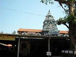
Sri Kundeswara temple
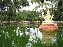
(ಶ್ರೀ ಕುಂದೇಶ್ವರ ದೇವಸ್ಥಾನ ) can be seen within the town.
Water landscape
Kundapura is surrounded on three sides by water / back water - and as such one can find good scenes of water and coconut trees all around. The boat point to Gangolli is one such beautiful place, with a vast area of the back waters of Haladi River, which joins the Arabian Sea nearby. From this point, the range of Western Ghats at a distance of 20 km (12 mi), including highest peak Kodachadri is visible.
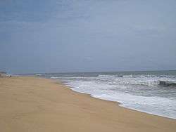
Kodi Beach
This is a nice beach located about 4 kilometres (2.5 mi) from Kundapura.
Kundapur Estuary
Kundapur Estuary is a very beautiful place, here Haladi river meets Arabian Sea. Gangolli which is almost 20 km by road from Kundapur Town can be seen from this point.
Kollur
Kollur(ಕೊಲ್ಲೂರು) is one of the Shakti Pithas established by Shankaracharya. Souparnika river flows here in the midst of dense forest. Kodachadri hill, with a height of about 3,800 feet (1.2 km) at the backdrop, is a suitable trekking spot. Trekkers can start trekking from Nagodi village near Kollur and reach Kodachadri peak after about three hours trekking. Thick forest, sholas, grass lands, and cool air are a specialty of this place. There is a moola stana of Kollur Goddess at Kodachadri. An iron pillar, said to be an ancient weapon used by Goddess Mookambika to kill the demon Kolasura, stands in front of a small temple near Travelers Bungalow. The antiquity of this iron pillar makes for an interesting sight. Sunset from Kodachadri Peak during winter is a rather spectacular sight. There is a traveller's bungalow, and other facilities are rudimentary with minimal basic facilities.
Sowkooru sri durgaparameshwari temple
Sri devi sowkooru durgaparameshwari temple is a very power ful goddess temple in kundapura taluq. he temple is located 12 kilometres (7.5 mi) from Kundapur. sri devi here give all in a pray...
This great temple is uniquely known for the arecanut flower prasada which falls from the head of the Goddess. This is supposed to be very powerful.
Sri Anegudde Vinayaka Temple
,
ಶ್ರೀ ವಿನಾಯಕ ದೇವಸ್ಥಾನ (Ganesh) Temple at Anegudde, between Kota, Udupi and Koteshwar towns. The temple is located 5 kilometres (3.1 mi) from Kundapur. Among the several temples in Kumbhashi Anegudde, Sri Vinayaka Temple is the oldest, and it is also the most popular in this region. This Ganesh temple is on a small hillock, giving the name Anegudde, "Ane" meaning elephant and "Gudde" meaning a hillock.
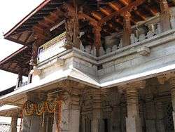
- Mekekattu Nadhikeshwara temple is an historical place. Located about 20 kilometres (12 mi) from Kundapur, it falls within the limits of Udupi Taluk, but is culturally connected to Kundapur. It is nearer to Barkuru in the Shiriyara village. Legend says it is a creation of sage Parashurama as applicable to all places of Coastal Karnataka. With the passage of time the area where the temple is situated has been called by different names. It attracts several visitors every year, particularly during annual festival, hasara, and sedi. Striking feature of Mekkekattu temple include a large collection of coloured, wooden idols, some of which measure up to 10 feet in height. Most of the wooden statues are in warrior dress, giving an impression that this entire row of wooden statues are made to remember an incidence of war that would have taken place here during 1600-1700 AD (no historic evidence for this war is found yet, but can be linked to Mogul / Bahamani Invasion). Some of the statues are like Muslim soldiers, some like maratha soldiers. Some even hold a replica of an old gun or swords, posed as if ready for war. All wooden statues are given local mythological names. Yettinahatti, very near to Mekke kattu, is an interesting place where bulls are worshiped, and may have some historical links with Mekke Kattu. There is one more small place called Karuvina Hatti about 35 kilometres (22 mi) from Udupi via Brahmavara – Barkur,Shiriyara
- Guddattu Vinayaka temple This particular temple, situated in the border area of Kundapur and Udupi taluks, has to be seen to be believed. Guddattu is a place of natural beauty. The History of Guddattu Sri Vinayaka Temple runs back for about 1700 years. The natural rock formation similar to Ganesh Idol is inside a small cave and the natural formation of cave is such that, around thousand Koda of water collects naturally and submerges the Ganesh Idol. It is said that the three foot idol of Lord Vinayaka was emerged by itself, attaching to a big rock. The black and grey stone structure of Lord Ganapathi is in a sitting position. His trunk is towards the right, eyes and legs clearly visible. The pooja of Ayarkoda is performed by devotees with much faith and devotion. The new rock Temple is constructed here, adjacent to a huge granite rock, which looks like a sleeping elephant. This temple is about 35 kilometres (22 mi) from Udupi via Brahmavara – Barkur, Shiriyara, about 15 kilometres (9.3 mi) from Kundapur via Koteshwara – Hunsemakhi -Guddeangady.
- Padukone is a coastal village located approximately 17 kilometres (11 mi) north of the taluk center. Part of the village is surrounded by the Souparnika River and one has to cross this river in an old wooden boat from Maraswami. Padukone is a beautiful village surrounded by coconut trees, water, and kudru.
- Basrur - Many temples are located here on the southern banks of the Varahi River. Historically, Basrur is the main and center place of Kundapur Taluk. This area has many historical structures. Traders from foreign countries used to bring their boats and ships to Basrur, which is a natural harbour, and trade their goods for pepper and good quality rice. During 19th and 20th centuries, this place was famous for a singing and dancing lady community and such ladies devoted their lives to singing, entertainment and mainly attending the fancy and needs of rich gentlemen of the area.
- Uppinakudru - Uppinakudru, or salt island, is located 6 kilometres (3.7 mi) north of Kundapur which is a taluk headquarters in Udupi District.
- Hoovinakere - It is the birthplace of the philosopher Vadiraja, who preached Dvaita philosophy after Madhvacharya.
- Koteshwara - The Koteshwara temple is an historical and religious centre. Here the lake adjacent to the temple is larger than the main temple. One of the many legends about this lake is that there is an underground tunnel to Vandaru Kambala Gadde which is at a distance of 20 kilometres (12 mi). The Pattabhiramachandra temple, Mariyamma Temple, and the Kodandarama Temple are located in the same place.
- Hattiangadi has another well-known temple of Lord Ganapathi, and many other ancient temples besides.
- Kirimanjeshwara - Located about 22 kilometres (14 mi) from Kundapur, it has the Kirimanjeshwara temple amidst beautiful surroundings. There is another old temple called the Agastyeshwara temple, named after Sage Agastya.
- Shankaranarayana - Located about 32 kilometres (20 mi) to the east of Kundapur, it is traditionally called Krodha Kshetra and is one of the seven places of pilgrimage in the region mentioned in the Skanda Purana.
- Trasi - Located about 12 kilometres (7.5 mi) to the North of Kundapur, Trasi has a beautiful 1 kilometre (0.62 mi) long beach with Turtle Bay and Beach Resort.
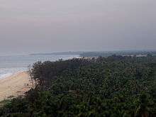
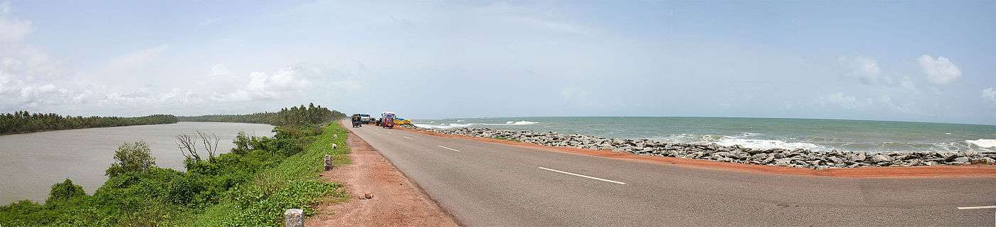
 Beach in Kundapur Taluk
 - Maravanthe One of Karnataka's most beautiful beaches. It is about 55 kilometres (34 mi) from Udupi. NH-66 runs right next to the beach and the Suparnika River flows on the other side of the road, creating a spectacular scenery and considered only one of its kind in India. The river Souparnika, which almost touches Arabian Sea here, makes a U turn and goes eastward to join the Sea only after a journey of more than 10 kilometres (6.2 mi), which is a geological wonder.
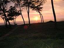
- Ottinene is a sunset point on the seashore, near Byndoor village on the national highway. The Kshitija Nature Resort, a beach and sunset point, are favorite spots with travelers here. Byndoor is a village near the sea.
- Bhandarkars college is a first grade university located in Kundapur. The college campus with adjacent cricket ground makes for a good sight.
- Kannadakudru It is a small island located in the middle of Gangolli, Uppinakudru, Hemmadi and Arate Bridge. Here, most of the people are farmers and grow only coconut & in rainy season paddy/Rice. This village is surrounded by salt water, which invades the river at high tide from the Arabic Sea. The landscape here is beautiful. Kudru means island; but how Kannad got joined to the name of the village is very interesting.
- Gangolli, even though very near to Kundapur, one has to travel more than 15 kilometres (9.3 mi) to reach this place as Panchagangavali River separates this from Kundapur town. One can also take boat ride, which depends on high tide timings. This is a beautiful place located at bank of five rivers and Arabian Sea. Fishing is the main activity. Veereshwara Temple is one of the oldest temples of Gangolli.
- Rattadi This place is between Halady and Amasebail. Named after god `Ratteshwara`, this is a small village near western ghats. Thick forests surround this village.
- Maranakatte This is a place located at a distance of about 18 kilometres (11 mi) from Kundapur and known for its Temple of "sri bramhalingeshwara", which is located in the bank of river Souparnika. It has a mythological connection with the Kollur "mookambika" temple, this being the place where the Goddess of Kollur killed Mookasura, the Rakshasa.
- Halady, a village at a distance of 22 kilometres (14 mi) from Kundapur town, is known mainly as a junction of roads leading to Shankaranarayana, Amasebail and Hebri. Halady River surrounds this village to the north. An old Tiles factory was busy burning red tiles up to the 1980s in Halady, but this industry has become obsolete and outdated because of dwindling forest cover, from where the logs were supplied to bake tiles and less demand for tiles in view of RCC houses. The Marlu chicku is one deity of Halady which attracts a large number of people, and another temple is of Laxmi Narasimha with seven foot stone statue. The river in front of this temple is a beautiful scene. Varahi Lift Irrigation Project work is going on in this area.
- Vakwadi This is a small village located between Anegudde and Huvinakere and about 2 kilometres (1.2 mi) from Koteswara. A temple of Mahalingeshwara about 2 kilometres (1.2 mi) from Anegudde is a place where forest, meadows, and trees make for an excellent view.
- BidkalkatteThis is a small village near Halady. It has a government-funded high school, college, and hospital. This is on the state highway kundapur-shimoga & udupi-shimoga.
- MolahalliThis is a small village near Bidkalkatte and known as birthplace of 'Sahakari Pithamaha' M.Shivarao. Shivaraya temple is located in this place. This village hosts a Kambala every winter, which is visited by surrounding villagers.
- HERIKUDRU This is river island near kundapur. This island well connected with NH17. There is one more subisland near this called Kamastar Kuru.
Flora and Fauna
.jpg)
Kundapur taluk is bound by Western Ghats, a world heritage site, on eastern side and all the villages,towns located on the eastern side of the taluk are bound by thick/average forests. These forests are home for variety of plants and animals, some of which are rare/endangered.. Forests surrounding Kollur.Amasebail etc. are harbouring Leopard,Tiger,Bison,King cobra,wild boars,sambar etc. are rare plants found include Rose wood etc. Mookambika Wild Life Sanctuary is located in the eastern side of the Taluk and is thickly wooded sanctuary.
References
- ↑ Navada, Gautham. "List of all villages in Kundapur". Coondapur.com. Coondapur.com. Retrieved 12 October 2013.
- 1 2 River Disputes in India: Kerala Rivers Under Siege By S. N. Sadasivan, Mittal Publications.(2003) Page:80.ISBN 8170999138, 9788170999133
- ↑ The World of Child Labor: An Historical and Regional Survey By Hugh D. Hindman.Pub:M.E.Sharpe.(2009) ISBN 9780765617071 Page:799.
- ↑ Youth Activism: An International Encyclopedia, Volume 1 By Lonnie R. Sherrod. Pub:Greenwood Publishing Group.(2006) Page:116
| Wikimedia Commons has media related to Kundapur. |
| Taluks | |
|---|---|
| Places |
|
| Temples | |
| Udupi cuisines | |
| Society | |
| Beaches | |
Coordinates: 13°48′00″N 74°42′00″E / 13.8000°N 74.7000°E