La Chapelle-Rainsouin
| La Chapelle-Rainsouin | |
|---|---|
|
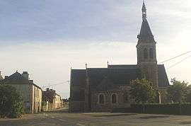
The church in La Chapelle-Rainsouin | |
 La Chapelle-Rainsouin | |
|
Location within Pays de la Loire region  La Chapelle-Rainsouin | |
| Coordinates: 48°05′58″N 0°31′08″W / 48.0994°N 0.5189°WCoordinates: 48°05′58″N 0°31′08″W / 48.0994°N 0.5189°W | |
| Country | France |
| Region | Pays de la Loire |
| Department | Mayenne |
| Arrondissement | Laval |
| Canton | Montsûrs |
| Government | |
| • Mayor (2008–2014) | Bernard Terrier |
| Area1 | 18.05 km2 (6.97 sq mi) |
| Population (2006)2 | 326 |
| • Density | 18/km2 (47/sq mi) |
| Time zone | CET (UTC+1) |
| • Summer (DST) | CEST (UTC+2) |
| INSEE/Postal code | 53059 / 53150 |
| Elevation |
73–138 m (240–453 ft) (avg. 112 m or 367 ft) |
|
1 French Land Register data, which excludes lakes, ponds, glaciers > 1 km² (0.386 sq mi or 247 acres) and river estuaries. 2 Population without double counting: residents of multiple communes (e.g., students and military personnel) only counted once. | |
La Chapelle-Rainsouin is a commune in the Mayenne department in north-western France.
See also
External links
| Wikimedia Commons has media related to La Chapelle-Rainsouin. |
This article is issued from Wikipedia - version of the 2/11/2016. The text is available under the Creative Commons Attribution/Share Alike but additional terms may apply for the media files.