Châtres-la-Forêt
| Châtres-la-Forêt | |
|---|---|
|
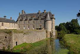
The Château de Montecler | |
 Châtres-la-Forêt | |
|
Location within Pays de la Loire region  Châtres-la-Forêt | |
| Coordinates: 48°08′03″N 0°25′50″W / 48.1342°N 0.4306°WCoordinates: 48°08′03″N 0°25′50″W / 48.1342°N 0.4306°W | |
| Country | France |
| Region | Pays de la Loire |
| Department | Mayenne |
| Arrondissement | Laval |
| Canton | Évron |
| Government | |
| • Mayor (2008–2014) | Claude Rouillard |
| Area1 | 13.60 km2 (5.25 sq mi) |
| Population (2006)2 | 752 |
| • Density | 55/km2 (140/sq mi) |
| Time zone | CET (UTC+1) |
| • Summer (DST) | CEST (UTC+2) |
| INSEE/Postal code | 53065 / 53600 |
| Elevation |
82–129 m (269–423 ft) (avg. 103 m or 338 ft) |
|
1 French Land Register data, which excludes lakes, ponds, glaciers > 1 km² (0.386 sq mi or 247 acres) and river estuaries. 2 Population without double counting: residents of multiple communes (e.g., students and military personnel) only counted once. | |
Châtres-la-Forêt is a commune in the Mayenne department in north-western France.
See also
| Wikimedia Commons has media related to Châtres-la-Forêt. |
This article is issued from Wikipedia - version of the 2/12/2016. The text is available under the Creative Commons Attribution/Share Alike but additional terms may apply for the media files.