La Cropte
| La Cropte | |
|---|---|
|
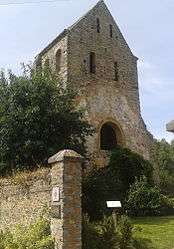
The tower of the old church of La Cropte | |
 La Cropte | |
|
Location within Pays de la Loire region  La Cropte | |
| Coordinates: 47°57′32″N 0°29′30″W / 47.9589°N 0.4917°WCoordinates: 47°57′32″N 0°29′30″W / 47.9589°N 0.4917°W | |
| Country | France |
| Region | Pays de la Loire |
| Department | Mayenne |
| Arrondissement | Laval |
| Canton | Meslay-du-Maine |
| Area1 | 14.15 km2 (5.46 sq mi) |
| Population (2006)2 | 223 |
| • Density | 16/km2 (41/sq mi) |
| Time zone | CET (UTC+1) |
| • Summer (DST) | CEST (UTC+2) |
| INSEE/Postal code | 53087 / 53170 |
| Elevation |
51–87 m (167–285 ft) (avg. 61 m or 200 ft) |
|
1 French Land Register data, which excludes lakes, ponds, glaciers > 1 km² (0.386 sq mi or 247 acres) and river estuaries. 2 Population without double counting: residents of multiple communes (e.g., students and military personnel) only counted once. | |
La Cropte is a commune in the Mayenne department in north-western France.
Geography
The Vaige forms most of the commune's north-western border, then flows southeastwards through the middle of the commune.
See also
| Wikimedia Commons has media related to La Cropte. |
This article is issued from Wikipedia - version of the 2/11/2016. The text is available under the Creative Commons Attribution/Share Alike but additional terms may apply for the media files.