Soulgé-sur-Ouette
| Soulgé-sur-Ouette | |
|---|---|
|
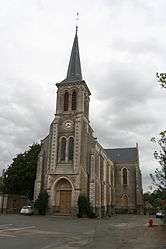
The church of Saint-Médard, in Soulgé-sur-Ouette | |
 Soulgé-sur-Ouette | |
|
Location within Pays de la Loire region  Soulgé-sur-Ouette | |
| Coordinates: 48°03′40″N 0°34′08″W / 48.0611°N 0.5689°WCoordinates: 48°03′40″N 0°34′08″W / 48.0611°N 0.5689°W | |
| Country | France |
| Region | Pays de la Loire |
| Department | Mayenne |
| Arrondissement | Laval |
| Canton | Montsûrs |
| Government | |
| • Mayor (2008–2014) | Jean-Michel Faguer |
| Area1 | 22.94 km2 (8.86 sq mi) |
| Population (2006)2 | 1,073 |
| • Density | 47/km2 (120/sq mi) |
| Time zone | CET (UTC+1) |
| • Summer (DST) | CEST (UTC+2) |
| INSEE/Postal code | 53262 / 53210 |
| Elevation |
74–124 m (243–407 ft) (avg. 100 m or 330 ft) |
|
1 French Land Register data, which excludes lakes, ponds, glaciers > 1 km² (0.386 sq mi or 247 acres) and river estuaries. 2 Population without double counting: residents of multiple communes (e.g., students and military personnel) only counted once. | |
Soulgé-sur-Ouette is a commune in the Mayenne department in north-western France.
See also
| Wikimedia Commons has media related to Soulgé-sur-Ouette. |
This article is issued from Wikipedia - version of the 2/11/2016. The text is available under the Creative Commons Attribution/Share Alike but additional terms may apply for the media files.