Prowers County, Colorado
| Prowers County, Colorado | |
|---|---|
|
Prowers County Courthouse in Lamar | |
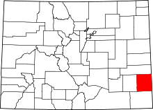 Location in the U.S. state of Colorado | |
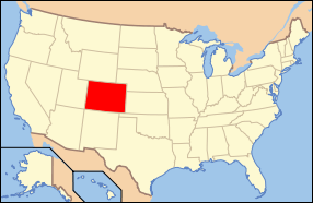 Colorado's location in the U.S. | |
| Founded | April 11, 1889 |
| Named for | John W. Prowers |
| Seat | Lamar |
| Largest city | Lamar |
| Area | |
| • Total | 1,644 sq mi (4,258 km2) |
| • Land | 1,638 sq mi (4,242 km2) |
| • Water | 5.9 sq mi (15 km2), 0.4% |
| Population (est.) | |
| • (2015) | 11,954 |
| • Density | 7.7/sq mi (3/km²) |
| Congressional district | 4th |
| Time zone | Mountain: UTC-7/-6 |
| Website |
www |

Prowers County is one of the 64 counties in the U.S. state of Colorado. As of the 2010 census, the population was 12,551.[1] The county seat is Lamar.[2] The county is named in honor of John W. Prowers, a leading pioneer in the lower Arkansas valley region.
Geography
According to the U.S. Census Bureau, the county has a total area of 1,644 square miles (4,260 km2), of which 1,638 square miles (4,240 km2) is land and 5.9 square miles (15 km2) (0.4%) is water.[3]
Adjacent counties
- Kiowa County - north
- Greeley County, Kansas - northeast
- Hamilton County, Kansas - east
- Stanton County, Kansas - southeast
- Baca County - south
- Bent County - west
Trails and byways
Antipode
Prowers County is home of the Antipode of La Roche Godon making it one of the few places in the continental United States with a non-oceanic antipode.[4][5]
Demographics
| Historical population | |||
|---|---|---|---|
| Census | Pop. | %± | |
| 1890 | 1,969 | — | |
| 1900 | 3,766 | 91.3% | |
| 1910 | 9,520 | 152.8% | |
| 1920 | 13,845 | 45.4% | |
| 1930 | 14,762 | 6.6% | |
| 1940 | 12,304 | −16.7% | |
| 1950 | 14,836 | 20.6% | |
| 1960 | 13,296 | −10.4% | |
| 1970 | 13,258 | −0.3% | |
| 1980 | 13,070 | −1.4% | |
| 1990 | 13,347 | 2.1% | |
| 2000 | 14,483 | 8.5% | |
| 2010 | 12,551 | −13.3% | |
| Est. 2015 | 11,954 | [6] | −4.8% |
| U.S. Decennial Census[7] 1790-1960[8] 1900-1990[9] 1990-2000[10] 2010-2015[1] | |||
As of the census[11] of 2000, there were 14,483 people, 5,307 households, and 3,725 families residing in the county. The population density was 9 people per square mile (3/km²). There were 5,977 housing units at an average density of 4 per square mile (1/km²). The racial makeup of the county was 78.57% White, 0.30% Black or African American, 1.22% Native American, 0.37% Asian, 0.03% Pacific Islander, 17.17% from other races, and 2.34% from two or more races. 32.91% of the population were Hispanic or Latino of any race.
There were 5,307 households out of which 37.40% had children under the age of 18 living with them, 54.60% were married couples living together, 10.90% had a female householder with no husband present, and 29.80% were non-families. 25.40% of all households were made up of individuals and 11.50% had someone living alone who was 65 years of age or older. The average household size was 2.67 and the average family size was 3.21.
In the county the population was spread out with 30.00% under the age of 18, 10.70% from 18 to 24, 26.50% from 25 to 44, 20.20% from 45 to 64, and 12.60% who were 65 years of age or older. The median age was 32 years. For every 100 females there were 101.00 males. For every 100 females age 18 and over, there were 98.70 males.
The median income for a household in the county was $29,935, and the median income for a family was $34,202. Males had a median income of $24,971 versus $20,526 for females. The per capita income for the county was $14,150. About 14.50% of families and 19.50% of the population were below the poverty line, including 27.10% of those under age 18 and 13.90% of those age 65 or over.
Communities
Historic sites
Gallery
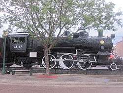 Former Atchison, Topeka, and Santa Fe railroad locomotive on display in Lamar
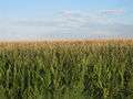 Cornfields flourish after a heavy rain in Prowers County, August 1, 2010
See also
- Outline of Colorado
- Index of Colorado-related articles
- National Register of Historic Places listings in Prowers County, Colorado
References
- 1 2 "State & County QuickFacts". United States Census Bureau. Retrieved February 11, 2014.
- ↑ "Find a County". National Association of Counties. Retrieved 2011-06-07.
- ↑ "US Gazetteer files: 2010, 2000, and 1990". United States Census Bureau. 2011-02-12. Retrieved 2011-04-23.
- ↑ http://www.findlatitudeandlongitude.com/antipode-map/#.VjluTK6rRTa
- ↑ http://www.weathergraphics.com/tim/antipode/
- ↑ "County Totals Dataset: Population, Population Change and Estimated Components of Population Change: April 1, 2010 to July 1, 2015". Retrieved July 2, 2016.
- ↑ "U.S. Decennial Census". United States Census Bureau. Retrieved June 10, 2014.
- ↑ "Historical Census Browser". University of Virginia Library. Retrieved June 10, 2014.
- ↑ "Population of Counties by Decennial Census: 1900 to 1990". United States Census Bureau. Retrieved June 10, 2014.
- ↑ "Census 2000 PHC-T-4. Ranking Tables for Counties: 1990 and 2000" (PDF). United States Census Bureau. Retrieved June 10, 2014.
- ↑ "American FactFinder". United States Census Bureau. Retrieved 2011-05-14.
External links
- Prowers County Government website
- Colorado County Evolution by Don Stanwyck
- Colorado Historical Society
 |
Kiowa County | Greeley County, Kansas | | |
| Bent County | |
Hamilton County, Kansas | ||
| ||||
| | ||||
| Baca County | Stanton County, Kansas |
Municipalities and communities of Prowers County, Colorado, United States | ||
|---|---|---|
| City | | |
| Towns | ||
| Unincorporated communities | ||

Coordinates: 37°58′N 102°24′W / 37.96°N 102.40°W