Cañon City, Colorado
| Cañon City, Colorado | |
|---|---|
| Home Rule Municipality | |
|
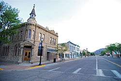
Downtown Cañon City (2010) | |
| Nickname(s): Climate Capital of Colorado, Cañon | |
| Motto: Gateway to the Authentic West | |
 Location within Fremont County and Colorado | |
| Coordinates: 38°26′31″N 105°13′15″W / 38.441889°N 105.220891°WCoordinates: 38°26′31″N 105°13′15″W / 38.441889°N 105.220891°W[1] | |
| Country | United States |
| State | Colorado |
| County | Fremont County Seat[2] |
| Settled | 1860 |
| Incorporated | April 3, 1872[3] |
| Government | |
| • Type | Home Rule Municipality[2] |
| • Mayor | Preston Troutman |
| Area | |
| • Total | 12.51 sq mi (32.40 km2) |
| • Land | 12.50 sq mi (32.37 km2) |
| • Water | 0.01 sq mi (0.03 km2) 0.09% |
| Elevation | 5,332 ft (1,625 m) |
| Population (2010) | |
| • Total | 16,400 |
| • Density | 1,312/sq mi (506.6/km2) |
| Time zone | MST (UTC-7) |
| • Summer (DST) | MDT (UTC-6) |
| ZIP codes[4] | 81212, 81215 (PO Box) |
| Area code(s) | 719 |
| INCITS place code | 0811810 |
| Website |
www |
Cañon City /ˈkænjən ˈsɪti/ is a Home Rule Municipality that is the county seat and the most populous municipality of Fremont County, Colorado, United States.[5] The city population was 16,400 at the 2010 United States Census.[6] Cañon City straddles the easterly flowing Arkansas River and is a popular tourist destination for sightseeing, whitewater rafting, and rock climbing. The city is noted for being the location of nine state and four federal prisons and penitentiaries, and a welcoming sign says, "Corrections Capital of the World."[7]
In 1994, the United States Board on Geographic Names approved adding the tilde to the official name of Cañon City, a change from Canon City as the official name in its decisions of 1906 and 1975.[8] It is one of the few U.S. cities to have an Ñ in its name, others being La Cañada Flintridge, California, Española, New Mexico, Peñasco, New Mexico, and Cañones, New Mexico.
History
Cañon City was laid out on January 17, 1858, during the Pike's Peak Gold Rush, but then the land was left idle. A new company "jumped the claim" to the town's site in late 1859, and it put up the first building in February 1860. This town was originally intended as a commercial center for mining in South Park and the upper Arkansas River.[9]
1860s to 1900
In 1861, the town raised two companies of volunteers to serve with the Second Colorado Infantry during the American Civil War. This regiment fought in skirmishes in nearby New Mexico and as far east as the Indian Territory (Oklahoma) and Missouri before ending its organization in 1865.
In 1862, A. M. Cassaday drilled for petroleum 6 miles (10 km) north of Cañon City, close to a known oil seep. Cassaday struck oil at the depth of 50 feet (15 m), and he completed the first commercial oil well west of the Mississippi River. He drilled five or six more wells nearby, and he refined kerosene and fuel oil from the petroleum. Cassaday sold the products in Denver.[10]
A number of metal ore smelters were built in Cañon City following the discovery of gold at Cripple Creek in 1891.
Historical designations
The Cañon City Downtown Historic District is an historic district that was listed on the National Register of Historic Places in 1983.[11]
Geography
Cañon City is located in eastern Fremont County at 38°26′48″N 105°13′42″W / 38.44667°N 105.22833°W (38.446800, -105.228305)[12] at an altitude of 5,332 feet (1,625 m). It sits primarily on the north side of the Arkansas River, just east of where the river exits from Royal Gorge. It is bordered to the south by the unincorporated community of Lincoln Park. Via U.S. Route 50, Pueblo is 39 miles (63 km) to the east and Poncha Springs is 62 miles (100 km) to the west. Colorado Springs is 45 miles (72 km) to the northeast.
According to the United States Census Bureau, the city has a total area of 12.5 square miles (32.4 km2), of which 0.01 square miles (0.03 km2), or 0.09%, is water.[6] Cañon City sits in the "high desert" land of southern Colorado, the same desert lands of Pueblo and Florence.
Climate
Climate Capital of Colorado
The city's nickname, "the Climate Capital of Colorado", derives from the combination of unique geography and 5,300-foot (1,600 m) elevation protecting the city from harsh weather conditions. The average daily high temperature in January is 14 °F (10 °C) warmer in Cañon City than in Grand Junction, even though the elevation of Cañon City is higher.[13]
The average minimum temperature in January is 20 °F (−7 °C). During July, overnight lows are 59 °F (15 °C) on average. Cañon City has a semi-arid climate (Köppen climate classification BSk).
| Climate data for Cañon City, Colorado | |||||||||||||
|---|---|---|---|---|---|---|---|---|---|---|---|---|---|
| Month | Jan | Feb | Mar | Apr | May | Jun | Jul | Aug | Sep | Oct | Nov | Dec | Year |
| Record high °F (°C) | 76 (24) |
77 (25) |
82 (28) |
88 (31) |
98 (37) |
102 (39) |
107 (42) |
100 (38) |
100 (38) |
91 (33) |
83 (28) |
76 (24) |
107 (42) |
| Average high °F (°C) | 49 (9) |
52 (11) |
58 (14) |
65 (18) |
73 (23) |
84 (29) |
90 (32) |
87 (31) |
79 (26) |
69 (21) |
56 (13) |
49 (9) |
67.6 (19.7) |
| Average low °F (°C) | 20 (−7) |
23 (−5) |
28 (−2) |
35 (2) |
44 (7) |
53 (12) |
59 (15) |
58 (14) |
48 (9) |
38 (3) |
28 (−2) |
21 (−6) |
38 (3) |
| Record low °F (°C) | −23 (−31) |
−16 (−27) |
−8 (−22) |
7 (−14) |
15 (−9) |
20 (−7) |
41 (5) |
37 (3) |
25 (−4) |
12 (−11) |
−24 (−31) |
−25 (−32) |
−25 (−32) |
| Average precipitation inches (mm) | 0.46 (11.7) |
0.38 (9.7) |
1.06 (26.9) |
1.47 (37.3) |
1.64 (41.7) |
1.24 (31.5) |
1.78 (45.2) |
2.05 (52.1) |
1.21 (30.7) |
0.72 (18.3) |
0.80 (20.3) |
0.49 (12.4) |
13.30 (337.8) |
| Source: Weather.com[14] | |||||||||||||
Neighborhoods
As Cañon City has grown, the city has both annexed surrounding communities and developed new subdivisions to create the city that exists today.
- Dawson Ranch
- Eagle Heights
- Fireman's Bluff
- Four Mile Ranch
- Gold Cañon
- Meadowbrook
- Orchard Park
- South Cañon, a historic neighborhood located on the west side south of the Arkansas River
- Sunrise Mesa
- Western Meadows
- Wolf Park
Parks and recreation
Cañon City is home to many city-owned parks, as well as parks owned by the Cañon City Area Recreation and Park District.
City owned parks
- Centennial Park, commonly known as "Duck Park"
- Denver & Rio Grande Western Park, commonly known as "Depot Park"
- Greydene Park
- Magdalene Park
- Margaret Park (originally Margarette Park)
- Mountain View Park, home of the city's skate park
- Red Canyon Park, a 500-acre (200 ha) park located 10 miles (16 km) north of the city
- Royal Gorge Park, home of the Royal Gorge Bridge and Park
- Rudd Park
- Temple Canyon Park
- Veterans Park, known for Entertainment in the Park concerts during the summer
Cañon City Area Recreation and Park District
The Cañon City Area Recreation and Park District, commonly called the Rec District, was created in 1965[15] to better serve the community's recreational needs with parks, the R.C. Icabone Pool (a public swimming pool), a dog park, an archery range and a ropes course along with a rec district office with a community room.
The following parks are operated and owned by the Rec District:
- John Griffin Park, located near the Sell's Avenue Trailhead of the Riverwalk
- Harrison Park, the former playground of the former Harrison Elementary School which had been relocated to a newer, larger school building housing both elementary and middle school students
- Pathfinder Regional Park, a joint-managed park located in the county between Cañon City and Florence
- Rouse Park
Demographics
| Historical population | |||
|---|---|---|---|
| Census | Pop. | %± | |
| 1870 | 229 | — | |
| 1880 | 1,501 | 555.5% | |
| 1890 | 2,825 | 88.2% | |
| 1900 | 3,775 | 33.6% | |
| 1910 | 5,162 | 36.7% | |
| 1920 | 4,551 | −11.8% | |
| 1930 | 5,938 | 30.5% | |
| 1940 | 6,690 | 12.7% | |
| 1950 | 6,345 | −5.2% | |
| 1960 | 8,973 | 41.4% | |
| 1970 | 9,206 | 2.6% | |
| 1980 | 13,037 | 41.6% | |
| 1990 | 12,687 | −2.7% | |
| 2000 | 15,431 | 21.6% | |
| 2010 | 16,400 | 6.3% | |
| Est. 2015 | 16,395 | [16] | 0.0% |
As of the census[18] of 2000, there were 15,431 people, 6,164 households, and 3,803 families residing in the city. The population density was 1,284.1 people per square mile (495.7/km²). There were 6,617 housing units at an average density of 550.6 per square mile (212.5/km²). The racial makeup of the city was 93.15% White, 1.59% African American, 1.04% Native American, 0.54% Asian, 0.06% Pacific Islander, 1.61% from other races, and 2.01% from two or more races. Hispanics or Latinos of any race were 8.33% of the population.
There were 6,164 households out of which 28.8% had children under the age of 18 living with them, 48.0% were married couples living together, 10.5% had a female householder with no husband present, and 38.3% were non-families. 33.7% of all households were made up of individuals and 17.2% had someone living alone who was 65 years of age or older. The average household size was 2.27 and the average family size was 2.90.
The age distribution was 23.5% under the age of 18, 6.7% from 18 to 24, 28.2% from 25 to 44, 21.5% from 45 to 64, and 20.1% who were 65 years of age or older. The median age was 40 years. For every 100 females there were 100.1 males. For every 100 females age 18 and over, there were 99.3 males.
The median income for a household in the city was $31,736, and the median income for a family was $42,917. Males had a median income of $31,258 versus $21,849 for females. The per capita income for the city was $16,970. About 7.1% of families and 11.5% of the population were below the poverty line, including 11.9% of those under age 18 and 9.6% of those age 65 or over.
Law
Along with a police department, sheriff's office and detention center, and a municipal court, Cañon City is home to the courts for Fremont County and the 11th Judicial District of Colorado.
Government
Cañon City is governed via the mayor-council system. The city council consists of seven members who are elected from districts. The mayor is elected by the entire city.
Economy
The area being situated along the Arkansas River has allowed for soil suitable to orchards, ranching and farming, but Cañon City has slowly transitioned from an agricultural community to more of a diverse economy including not only agriculture, but tourism, education, manufacturing, medicine and many others.
Major employers
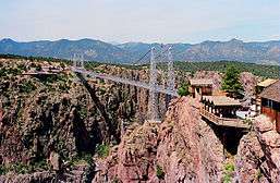
The major employers in Cañon City include the Colorado Department of Corrections and Centura Health (owner of St. Thomas More Hospital and the Progressive Care Center). Cañon City also depends on its tourism industry which includes the Royal Gorge Route Railroad, Royal Gorge Bridge and Park and various other attractions.
Prisons
Colorado Department of Corrections operates the Colorado Territorial Correctional Facility in Cañon City.[19] In addition to several correctional facilities near Cañon City in unincorporated areas in Fremont County, Colorado State Penitentiary, the location of the state death row and execution chamber[20] is in Fremont County.[21] Other state prisons in Fremont County include Arrowhead Correctional Center,[22] Centennial Correctional Facility,[23] Fremont Correctional Facility,[24] Four Mile Correctional Center,[25] and Skyline Correctional Center.[26]
On October 3, 1929, a riot at the prison claimed 13 lives.[27]
The Colorado Women's Correctional Facility near Cañon City in unincorporated Fremont County, was decommissioned on June 4, 2009.[28][29]
Prisons have served an important significance to both Cañon City and the surrounding areas of Fremont County, as well as to the state of Colorado. To learn more about the history of prisons in Colorado, the Museum of Colorado Prisons has been given the role of preserving and presenting the past of the state's corrections system.
Tourism
From Cañon City's Downtown Historic District located in the heart of the city to the Royal Gorge Bridge, there are many places to see and visit in the area.
Media
Cañon City is home to a daily newspaper called the Cañon City Daily Record, an FM radio station, Star Country 104.5 FM and a long-running AM radio station known as KRLN NewsRadio 1400 AM.
Transportation
Transportation in the Cañon City area consists of cab service, shuttle bus service, and a downtown wagon ride. The Royal Gorge Bridge trolley had also been used during special events (it was destroyed in the Royal Gorge Fire, but it was reserved for use by the Royal Gorge Bridge & Park. Jeep tours and Segway tours are also available to explore local parks such as Red Canyon Park or scenic places such as Skyline Drive.
Major roads and highways
The area is served by one state and one U.S. highway with a mix of city and county roads to navigate the city or connect to neighboring areas.
State and national highways
- U.S. Highway 50 - named Royal Gorge Boulevard from 1st Street to 15th Street in downtown Cañon
- State Highway 115 - connects the city to nearby Florence and Penrose, ending in Colorado Springs, Colorado
City and county roads
- 4th Street - connecting Downtown with South Cañon, Oak Creek Grade, Prospect Heights, and Capitol Hill
- 5th Street - serves as a north-south connector from Downtown north, allows traffic from Skyline Drive to return to U.S. 50
- 9th Street - serves as a carrier of CO 115 from the roundabout to the junction with U.S. 50, heads north and ends at Washington Street
- 15th Street - main route north to the hospital, a fire station and a small cluster of businesses
- Orchard Avenue
- Raynolds Avenue/Ash Street - runs from center of East Cañon to CO 115 via a county road, changes to a gravel road and becomes Chandler Road
- MacKenzie / Four Mile Lane - routed to connect from CO 115 as a carrier of CR 20 until the city limits, at Hwy 50, heads north as Four Mile Lane
Scenic routes
- Skyline Drive, major scenic route overlooking Cañon City that was originally built by local inmates at the Territorial Prison
Railroads
- The Union Pacific Railroad mothballed the Tennessee Pass line in 1997. In 1998 Rock and Rail LLC was formed, and began operating on the former Union Pacific track between Cañon City and Parkdale. It also operates between Pueblo and Cañon City on lines purchased from the UP Railway. The tourist line Cañon City and Royal Gorge Railroad also operates on the RRRR's track.
Education
- See also Cañon City School District
Cañon City's school system is under the direction of the Cañon City School District Fremont RE-1.[30] The district currently has four elementary schools, one charter school, one school serving as both an elementary school and middle school, one middle school and one high school, Cañon City High School. For the higher education needs of the community, Pueblo Community College provides a branch campus on the west end of the city along U.S. Highway 50.
Places of interest
- Cañon City State Armory
- Cañon City Downtown Historic District, listed on the National Register of Historic Places
- The Owl Cigar Store
- Colorado State Penitentiary
- Dinosaur Depot Museum, currently housed at the Cañon City Municipal Building
- Peabody Mansion, home of the Cañon City Chamber of Commerce
- Museum of Colorado Prisons
- Robison Mansion
- Royal Gorge Bridge and Park
- Royal Gorge Route Railroad
- Cañon City Municipal Building, also known as the Royal Gorge Regional Museum and History Center
Former places of interest
Notable residents
- Robert Wesley Amick, artist
- Don Bendell, writer
- Jack Christiansen, NFL hall-of-famer (Detroit Lions)
- Donald S. Fredrickson, medical researcher, former director of the National Institutes of Health, and first president of the Howard Hughes Medical Institute; born in Canon City
- Skip Konte, musician, "Wizard of all Northern Realms"
- Vice Admiral Emory S. Land (U.S. Navy), born in Cañon City
- Dave Merrick, artist
- James Hamilton Peabody, former Colorado governor
Popular culture
The city is depicted in an alternate history in the 1963 novel by Philip K. Dick The Man in the High Castle and 2015 television series of the same name on which it is based. Canon City is located in the neutral zone situated between the puppet states of the Japanese Pacific States and Greater Nazi Reich in the former United States.[31]
Sister cities
See also
References
- ↑ "2014 U.S. Gazetteer Files: Places". United States Census Bureau. July 1, 2014. Retrieved January 5, 2015.
- 1 2 "Active Colorado Municipalities". State of Colorado, Department of Local Affairs. Archived from the original on 2010-11-23. Retrieved 2007-09-01.
- ↑ "Colorado Municipal Incorporations". State of Colorado, Department of Personnel & Administration, Colorado State Archives. 2004-12-01. Retrieved 2007-09-02.
- ↑ "ZIP Code Lookup". United States Postal Service. Archived from the original on September 3, 2007. Retrieved September 7, 2007.
- ↑ "Find a County". National Association of Counties. Archived from the original on 2011-05-31. Retrieved 2011-06-07.
- 1 2 "Geographic Identifiers: 2010 Census Summary File 1 (G001): Cañon City city, Colorado". American Factfinder. U.S. Census Bureau. Retrieved April 20, 2016.
- ↑ Welch, Michael; Turner, Fatiniyah (2007). "Private Corrections, Financial Infrastructure, and Transportation: The New Geo-Economy of Shipping Prisoners". Social Justice. 34 (3): 57. JSTOR 29768464. (registration required (help)).
- ↑ "Cañon City". Geographic Names Information System. United States Geological Survey.
- ↑ "Canon City, its rise and progress," Canon City Times, 10 November 1860, p.4.
- ↑ Francis M. Van Tuyl and Arthur E. Brainerd (1960), Historical summary, in Mineral Resources of Colorado First Sequel, Denver: Colorado Mineral Resources Board, p.491-492.
- ↑ National Park Service (2008-04-15). "National Register Information System". National Register of Historic Places. National Park Service.
- ↑ "US Gazetteer files: 2010, 2000, and 1990". United States Census Bureau. 2011-02-12. Retrieved 2011-04-23.
- ↑ http://www.weatherbase.com/weather/city.php3?c=US&s=CO&refer=
- ↑ Weather.com—. Retrieved 30 July 2010.
- ↑ "Cañon City Area Recreation and Park District: About Us". Retrieved 5 February 2014.
- ↑ "Annual Estimates of the Resident Population for Incorporated Places: April 1, 2010 to July 1, 2015". Retrieved July 2, 2016.
- ↑ "Census of Population and Housing". Census.gov. Archived from the original on May 11, 2015. Retrieved June 4, 2015.
- ↑ "American FactFinder". United States Census Bureau. Archived from the original on 2013-09-11. Retrieved 2008-01-31.
- ↑ "Colorado Territorial Correctional Facility." Colorado Department of Corrections. Retrieved on August 15, 2010. "125 West US 50 Canon City, CO, 81215."
- ↑ "Death Row FAQ." (Archive) Colorado Department of Corrections. Retrieved on August 15, 2010.
- ↑ "Colorado State Penitentiary." Colorado Department of Corrections. Retrieved on August 15, 2010. "E US Highway 50 Evans Blvd Cañon City, CO, 81215"
- ↑ "Arrowhead Correctional Center." Colorado Department of Corrections. Retrieved on August 15, 2010. "E US Highway 50 Evans Blvd Cañon City, CO, 81215"
- ↑ "Centennial Correctional Facility." Colorado Department of Corrections. Retrieved on August 15, 2010. "E US Highway 50 Evans Blvd Cañon City, CO, 81215"
- ↑ "Fremont Correctional Facility." Colorado Department of Corrections. Retrieved on August 15, 2010. "E US Highway 50 Evans Blvd Cañon City, CO, 81215"
- ↑ "Four Mile Correctional Center." Colorado Department of Corrections. Retrieved on August 15, 2010. "E US Highway 50 Evans Blvd Cañon City, CO, 81215"
- ↑ "Skyline Correctional Center." Colorado Department of Corrections. Retrieved on August 15, 2010. "E US Highway 50 & Evans Blvd Cañon City, CO, 81215"
- ↑ http://blogs.denverpost.com/library/2013/10/28/1929-colorado-state-penitentiary-riot/8856/
- ↑ Mitchell, Kirk. "Cañon City women's prison closes today." The Denver Post. June 4, 2009. Retrieved on August 15, 2010.
- ↑ "GDE Testing Centers by City." Colorado Department of Education. Retrieved on August 15, 2010. "Colorado Women's Correctional Facility 3800 Grandview Ave. | Canon City, CO 81215."
- ↑ "Cañon City Schools". Retrieved 11 November 2013.
- ↑ Enger, Jeremy (November 19, 2015). "Red, Reich and Blue: Building the World of 'The Man in the High Castle'". New York Times. Retrieved 23 February 2016.
External links
| Wikivoyage has a travel guide for Cañon City. |
| Wikimedia Commons has media related to Cañon City, Colorado. |
- City of Cañon City official website
- Cañon City news and information from the Cañon City Daily Record
- CDOT map of Canon City
- Royal Gorge Region, official visitors guide
- Cañon City & Royal Gorge Visitor Information
- Cañon City Daily Record
- Cañon City School District
- Cañon City Chamber of Commerce
Area attractions
- Historic Royal Gorge Route Railroad
- Museum of Colorado Prisons
- Royal Gorge Route
- Royal Gorge Bridge and Park
- Royal Gorge Whitewater Rafting Trips
Municipalities and communities of Fremont County, Colorado, United States | ||
|---|---|---|
| Cities |  | |
| Towns | ||
| CDPs | ||
| Unincorporated communities | ||
