List of districts in Barking and Dagenham
This is a list of districts in the London Borough of Barking and Dagenham.
Postcode areas in Barking and Dagenham are IG and RM.
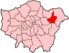
Barking and Dagenham within Greater London
Neighbourhoods
| District | Post town | Postcode area | Coordinates | OS grid ref |
|---|---|---|---|---|
| Barking | BARKING | IG | 51°32′10″N 0°04′37″E / 51.536°N 0.077°E | TQ440840 |
| Becontree | DAGENHAM | RM | 51°32′53″N 0°08′31″E / 51.548°N 0.142°E | TQ485855 |
| Becontree Heath | DAGENHAM | RM | 51°33′47″N 0°09′07″E / 51.563°N 0.152°E | TQ493871 |
| Castle Green | DAGENHAM | RM | 51°31′59″N 0°07′19″E / 51.533°N 0.122°E | TQ472837 |
| Chadwell Heath | ROMFORD | RM | 51°34′30″N 0°08′38″E / 51.575°N 0.144°E | TQ485885 |
| Creekmouth | BARKING | IG | 51°31′08″N 0°05′56″E / 51.519°N 0.099°E | TQ457820 |
| Dagenham | DAGENHAM | RM | 51°32′20″N 0°08′31″E / 51.539°N 0.142°E | TQ485845 |
| Marks Gate | ROMFORD | RM | 51°35′35″N 0°08′38″E / 51.593°N 0.144°E | TQ485905 |
| Rush Green | ROMFORD | RM | 51°33′58″N 0°10′19″E / 51.566°N 0.172°E | TQ505875 |
Electoral wards
The borough is divided into the Abbey, Alibon, Becontree, Chadwell Heath, Eastbrook, Eastbury, Gascoigne, Goresbrook, Heath, Longbridge, Mayesbrook, Parsloes, River, Thames, Valence, Village and Whalebone wards.
| Districts | | |
|---|---|---|
| Attractions | ||
| Parks and open spaces | ||
| Constituencies |
| |
| Tube and rail stations | ||
| Other topics | ||
This article is issued from Wikipedia - version of the 11/16/2015. The text is available under the Creative Commons Attribution/Share Alike but additional terms may apply for the media files.