St Helier, London
| St Helier | |
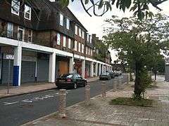
 Shops at Green Lane, St Helier |
|
 St Helier |
|
| Population | 11,949 (2011 Census Sutton Ward)[1] 10,414 (2011 Census. Merton Ward)[2] |
|---|---|
| OS grid reference | TQ265664 |
| London borough | Merton |
| Sutton | |
| Ceremonial county | Greater London |
| Region | London |
| Country | England |
| Sovereign state | United Kingdom |
| Post town | MORDEN |
| Postcode district | SM4 |
| Post town | CARSHALTON |
| Postcode district | SM5 |
| Dialling code | 020 |
| Police | Metropolitan |
| Fire | London |
| Ambulance | London |
| EU Parliament | London |
| UK Parliament | Mitcham and Morden |
| Carshalton and Wallington | |
| London Assembly | Merton and Wandsworth |
| Croydon and Sutton | |
Coordinates: 51°22′57″N 0°11′01″W / 51.38256°N 0.18361°W
St. Helier (/səntˈhɛlɪə/[3]) is a residential cottage estate in the London boroughs of Merton and Sutton. The portion of the estate north of Green Lane and Bishopsford Road is in Merton, the rest is in Sutton.
History
The estate was built between 1928 and 1936 by the London County Council for the re-housing of people from decaying inner London areas. Landscaping on the large-scale town planning scheme was by landscape architect Edward Prentice Mawson.
Its development was spurred by the opening of Morden Underground station in 1926, and the Wimbledon to Sutton railway line in 1930, with a station at St Helier. These services provided rapid links into central London for the residents.

The estate was named in honour of Lady St. Helier, who was an LCC Alderman from 1910 to 1927. It was the second largest (after the Becontree-Dagenham estate) of a series of 'out-county' cottage estates and was based on the Garden City ideas of Ebenezer Howard. The area had previously consisted largely of lavender fields, the last remnants of the famous Mitcham lavender industry.
In remembrance of the area's historic ownership by Westminster Abbey, the roads are named in alphabetical order after Monasteries and Abbeys starting in the north-west with Aberconway Road and ending with Woburn Road in the south-east.
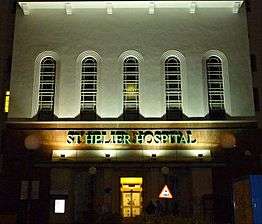
The imposing St. Helier Hospital was opened in 1938. John Major, UK Prime Minister from 1990 to 1997, was born there.
The estate's Bishop Andrewes Church, in Wigmore Road, was designed by the architect Geddes Hyslop in 1933.[4]
Today
Today ownership of housing on the estate is split between private and local authority, with many people taking advantage of the right to buy scheme since the 1970s. The hospital still exerts an imposing presence on the estate, both economically and physically. Most of the buildings are original and many are still being used for their original purposes. There has been a little amount of infilling around the outskirts, and the estate now merges into the suburbs of Sutton, Carshalton and Morden.
The area is served by London Bus routes 80, 151, 154, 157, 164, 280, S1, S4, N44.
Nearest places
References
- ↑ "Sutton Ward population 2011". Neighbourhood Statistics. Office for National Statistics. Retrieved 9 October 2016.
- ↑ "Merton Ward population 2011". Neighbourhood Statistics. Office for National Statistics. Retrieved 11 October 2016.
- ↑ "Saint Helier". Collins Dictionary. n.d. Retrieved 23 September 2014.
- ↑ (Nikolaus Pevsner), Surrey ("Buildings of England") revised by Ian Nairn and Bridget Cherry), 1971:446
External links
- History of St.Helier
- St.Helier Hospital
- St.George's Church, St.Helier
- St. Peter's and Bishop Andrewes, St Helier
- London City Mission : St Helier Christian Centre
- www.StHelierEstate.co.uk

