List of islands in the Greater Manila Area
This is a list of islands in the Greater Manila Area in the Philippines.
There are several small islands located within the Manila metropolitan area, particularly along the coast of Manila Bay, both natural and artificial. Many of these islands were formed by the Pasig River delta and consist of sand and mudflats. Artificial islands have been built particularly in Tondo's North Port area, the Navotas fish port area, and the Las Piñas–Parañaque reclamation area.
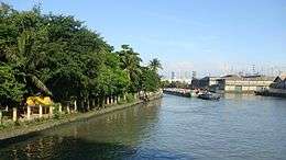
Historically, the City of Manila consisted of small islands formed by rivulets known as esteros.[1] They include Binondo, formed by the Estero de Binondo and Estero de la Reina, and San Miguel, formed by the Estero de San Miguel and Estero de Sampaloc. The walled district of Intramuros was itself an island surrounded by moats during the Spanish colonial period. Many of these waterways have been filled over the years as a result of urbanization.
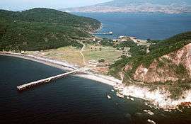
Near the entrance to the Manila Bay is a group of islands, the largest of which is Corregidor. Although administered as part of the province of Cavite, these islands are linked historically to Manila serving as part of the city's defense system through much of the Spanish and American colonial eras.
List of islands
Metro Manila


- Dampalit Island
- Engineer's Island
- A 25-30-hectare artificial island which contains the Baseco urban poor community separated from the Manila South Harbor by a narrow channel at the mouth of the Pasig River.[3]
- Freedom Island
- Isla de Balut
- An artificial island in the Manila North Harbor in Tondo bounded on the north by Estero de Sunog Apog (Estero de Marela), on the south and east by Estero de Vitas, and the Manila Bay on the west.
- Isla de Convalecencia
- The only island dividing the Pasig River in the City of Manila located in the district of San Miguel.
- Isla de Provisor
- A small island in northwestern Paco district surrounded by Estero de Provisor, Estero del Tanque and the Pasig River.
- Isla Pulo
- An island sitio north of the Navotas main island.
- Long Island
- One of three artificial islands that form the Las Piñas–Parañaque Critical Habitat and Ecotourism Area.
- Malabon Island
- The Malabon city proper is situated on one of the six islands which originally comprised the city of Malabon.[2] It is bounded on the north by Dampalit River, on the east and south by Tullahan River and on the west by the Navotas and Tanza rivers which separate it from Navotas.
- Maysilo Island
- An island barangay and one of six islands in the mangrove swamps north of Manila which originally comprised the city of Malabon.[2]
- Navotas Fish Port Complex
- An artificial island immediately to the north of Isla de Balut, separated from the main island of Navotas on the north by the Bangkulasi Channel and Tullahan River, on the east from Caloocan by the Navotas River, and on the south by Estero de Sunog Apog (Estero de Marela).
- Navotas Island
- Tanza Island
- An island barangay in Navotas surrounded by the Tangos River, Batasan River and Tanza River.
Manila Bay Islands

- Caballo Island
- Carabao Island
- Corregidor Island
- El Fraile Island
- La Monja Island
- Limbones Island
- Los Cochinos Islands
Central Luzon

- Camara Island
- Capones Island
- Egg Islands
- Hermana Mayor Island
- Hermana Menor Island
- Los Frailes Islands
- Magalawa Island
- Matalvi Island
- Pamana (Pequeña) Island
- Pampanga River Delta Islands
- Panatag Shoal or Scarborough Shoal (also claimed by China and Taiwan)
- Potipot Island
- Salvador Island
- Silanguin Island
- Subic Chiquita Island
- Subic Grande Island
- Tabones Island
Calabarzon
- Alabat Island
- Alibijaban Island
- Anilon Island
- Apat Island
- Bakaw-Bakaw Island
- Balot Island
- Baluti Island
- Binombonan Island
- Bird Island
- Bonga Island
- Bonito Island
- Bubuin Island
- Burunggoy Island
- Caban Island
- Cagbalete Island
- Calamba Island
- Culebra Island
- Dalig Island
- Dampalitan Island
- Fortune Island
- Ikulong Island
- Isla Puting Bato Island
- Lagdauin Island
- Lambauing Island
- Ligpo Island
- Malahi Island
- Malajibomanoc Island
- Mangayao Island
- Manlanat Island
- Maricaban Island
- Napayong Island
- Pagbilao Chica Island
- Pagbilao Grande Island
- Palasan Island
- Patayan Island
- Santa Amalia Island
- Sombrero Island
- Talabaan Islands
- Talim Island
- Twin Island
- Verde Island
- Volcano Island
See also
References
- ↑ "Physiognomy". City of Manila Tourism. Retrieved 18 July 2015.
- 1 2 3 McLennan, Marshall S. The Central Luzon Plain: Land and Society on the Inland Frontier. Alemar-Phoenix Publishing House. Retrieved 18 July 2015.
- ↑ "Baseco and its Proclamation" (PDF). Ombudsman of the Philippines. Retrieved 18 July 2015.
- ↑ "City Ecological Profile" (PDF). Navotas City Government. Retrieved 18 July 2015.