Transportation in Metro Manila
_(14765708731).jpg)
The transportation system of Metro Manila is a cooperation of complex systems of infrastructure. The first automobile and trams in the Philippines first ran through the city. Throughout the metropolis, different means of transportation can be used such as buses, jeepneys, taxis, trains, tricycles, and even horse carriages (Kalesa), which are now only used in the major streets of Manila. Metro Manila is served by three different railway networks: the Manila Light Rail Transit System (composed of LRT-1 and LRT-2), the Manila Metro Rail Transit System (composed of the MRT-3) and the Philippine National Railways (composed of the PNR Metro Commuter). Manila is also the headquarters of the main terminal of the Philippine National Railways.
Public transport
Manila, being a major city, offers various transportation options. The most famous of these modes is the public jeepney, which has been in use since the years immediately after World War II. Buses, air-conditioned metered taxi and Tamaraw FX mini-vans are also popular forms of transportation. Auto rickshaws (referred to as "tricycles" in the Philippines) and pedicabs are used for short distances. In some areas, especially in Divisoria, two stroke motors are fitted in the pedicabs and are used for goods transport. Regardless of modernity, horse-drawn calesas are still used in the streets of Binondo and Intramuros. Buses and taxis are also other important means of public transportation in the metropolis.
Trains are now also being a popular means of public transportation in Metro Manila. The metropolis is served by the Manila Light Rail Transit System (LRT-1 and LRT-2), the Manila Metro Rail Transit System (MRT-3) and the Philippine National Railways (PNR). The automated guideway transit system in UP Diliman will be the first of its kind in the Philippines. It will be developed within the campus of the University of the Philippines Diliman in Quezon City and will serve as a test track for the first mass transit system to be built and developed in the country by local engineers.[1]
Land transportation
Roads
.JPG)

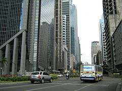
The main roads of Metro Manila are organized around a set of radial and circumferential roads that radiate and circle in and around Manila proper. Roxas Boulevard, easily the most well-known of Manila's streets, line the southern shores of Manila with Manila Bay. The boulevard is part of Radial Road 1 that leads south to the province of Cavite. Epifanio de los Santos Avenue or EDSA serves as an important highway in the metropolis. It is also the main thoroughfare linking the different cities of the metropolis. Another well-known radial road is España Boulevard (part of Radial Road 7) that starts in Quiapo and ends at the Welcome Rotonda along the border with Quezon City. Pres. Sergio Osmeña Sr. Highway, part of the South Luzon Expressway or Radial Road 3 is the most important highway linking Manila with the provinces of southern Luzon. Katipunan Avenue, Quezon Avenue, Commonwealth Avenue, Ayala Avenue, Aurora Boulevard, Taft Avenue, and the C-5 road are also other important roads in Metro Manila.
Bridges

There are a total of sixteen bridge spans in Metro Manila that crosses the Pasig River, including three rail bridges, the LRT Line 1, MRT Line 3 and the Philippine National Railways track. The bridges listed below are in a west to east order, with the first bridge nearest to the mouth of the Pasig River into Manila Bay.
- Roxas Bridge - formerly called Del Pan Bridge (San Nicolas to Port Area)
- Jones Bridge - formerly called Puente de España (Binondo to Ermita)
- MacArthur Bridge (Sta. Cruz to Ermita)
- LRT-1 (Carriedo Station to Central Station)
- Quezon Bridge (Quiapo to Ermita)
- Ayala Bridge (San Miguel to Ermita)
- Mabini Bridge - formerly called Nagtahan Bridge (Sta. Mesa to Pandacan)
- Philippine National Railways (Santa Mesa Station to Pandacan Station)
- Padre Zamora Bridge formerly called Pandacan Bridge (Sta.Mesa to Pandacan)
- Lambingan Bridge (Sta. Ana)
- Makati-Mandaluyong Bridge
- MRT-3 (Boni Station to Guadalupe Station)
- Rockwell Bridge (Makati to Mandaluyong)
- Guadalupe Bridge (Makati to Mandaluyong)
- C.P. Garcia Bridge (Makati to Pasig)
- Kaunlaran Bridge (Pasig)
- Bambang Bridge (Pasig)
- Kalawaan Bridge (Pasig)
- Napindan Bridge (Pasig to Taguig)
Railways
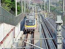
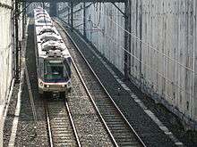
Development of the mass transit system began with its inception in the 1970s under the Marcos administration, making it the first light rail transport in Southeast Asia. Recently, the system saw a massive multibillion-dollar expansion in correlation with the rising population of the metropolis; its purpose: to create an alternative form of transportation to solve the demand of an increasingly mobile workforce. The metropolis is served by the Manila Light Rail Transit System (LRT-1 and LRT-2), the Manila Metro Rail Transit System (MRT-3) and the Philippine National Railways (PNR Metro Commuter).
The Manila Light Rail Transit System, popularly known as the LRTA system is one of the main railway networks of Metro Manila. It has a total of 31 stations composed of 20 stations for LRT-1 and 11 stations for LRT-2, along over a total of 31 kilometers of grade separated track which is composed of Line 1's 19.65 kilometers and Line 2's 13.80 kilometers. The LRT Line 1 which opened in 1984, covers parts of the Taft Avenue, Rizal Avenue, and Epifanio de los Santos Avenue (EDSA). Line 1 travels a north–south route which passes through the cities of Paranaque, Pasay, Manila, Caloocan, and Quezon City. While on the other hand, the LRT Line 2 which was completed in 2004, covers parts of Recto Avenue, Legarda Street, Magsaysay Boulevard, Aurora Boulevard, and Marikina-Infanta Highway (Marcos Highway). Line 2 travels in an east–west route which passes through the cities of Manila, Marikina, San Juan, and Quezon City.
The Manila Metro Rail Transit System is also one of the main railway networks of Metro Manila. The MRT Line 3 which was completed in 2000, covers most parts of Epifanio de los Santos Avenue (EDSA), one of Metro Manila's main thoroughfares. The MRT-3 has 13 stations along its 16.95 kilometers of grade separated track. Line 3 travels a north-south route which passes through the cities of Makati, Mandaluyong, Pasay and Quezon City.
Apart from the LRT-1, LRT-2, and MRT-3, the Philippine National Railways (PNR) also serves the metropolis via the PNR Metro Commuter Line. PNR is a state-owned railway company of the Philippines, which operates a single line of track in Metro Manila and Luzon.
In addition, the city is the hub of a railway system on Luzon. The main terminal of the Philippine National Railways is in the Tondo district. Railways extend from this terminal north to San Fernando in La Union and south to Legazpi in Albay, though only the southern railway is currently in operation.
Air transportation
Airports
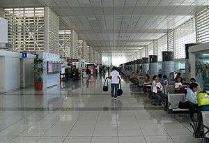
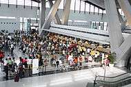
Ninoy Aquino International Airport (NAIA) is the main international gateway to the Philippines. Located along the border between Pasay and Parañaque, about seven kilometers south of Manila city proper, and southwest of Makati, the airport serves the national capital region and nearby provinces. A second terminal, Terminal 2 (or the Centennial Terminal) opened in October 1999. The Philippines' official flag-carrier Philippine Airlines uses this terminal exclusively for both its domestic and international service, while all other international flights use the original NAIA terminal. A third terminal (NAIA-3) opened in August 2008. It currently houses the domestic flights of Air Philippines, All Nippon Airways and Cebu Pacific's international and domestic flights. The main carrier serving NAIA is Philippine Airlines. KLM is the only European airline to serve the airport.
Officially, NAIA is the only airport serving the Manila area. However, both NAIA and Clark International Airport, located in the Clark Freeport Zone in Angeles, Pampanga serve the Manila area, with CIA catering mostly to low-cost carriers that avail themselves of the lower landing fees than those charged at NAIA. In 2010, NAIA terminal carried 27.1 million passengers, making it to the top 50 of the world's busiest airports by passenger traffic. In 2011, all terminals at NAIA handled a record breaking annual passenger traffic of 29,552,264 making one of the busiest airports in Asia. It is also the busiest airport in the country.[2]
Water transportation

Seaports and piers
The Port of Manila, located in the vicinity of Manila Bay, is the chief seaport of the Philippines. It primarily serves the city's commercial needs. North Harbor and South Harbor experience busy periods during long holidays such as Holy Week, All Saints Day and the Christmas holidays.
Pasig River Ferry Service
The Pasig River Ferry Service operates 17 stations along the Pasig River from Plaza Mexico in Intramuros to Pasig. The ferry service is the only water-based transportation that cruised the Pasig River.
See also
- Transportation in the Philippines
- Department of Public Works and Highways
- Department of Transportation
- Major roads of the Philippines
- Strong Republic Nautical Highway
References
- ↑ Patria, Kim Arveen (November 26, 2012). "New UP monorail coaches arrive". Yahoo! News.
- ↑ Amojelar, Darwin G. (July 3, 2012). "NAIA is Philippines' busiest airport - NSCB". InterAsksyon.
| Topics |  | |
|---|---|---|
| Government |
| |
| Districts | ||
| Legislative districts | ||
| ||