San Juan, Metro Manila
| San Juan | ||
|---|---|---|
| Highly-Urbanized City | ||
| Dakilang Lungsód ng San Juan (Great City of San Juan) | ||
|
Skyscrapers along Annapolis Street in Greenhills | ||
| ||
| Nickname(s): Heart of Metro Manila; Home of Philippine Presidents; Tiangge Capital of the Philippines | ||
|
Motto: Todo Asenso, San Juan! ("Progress, San Juan!") Diwa ng 1896 ("Spirit of 1896") | ||
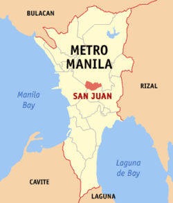 Location within Metro Manila | ||
.svg.png) San Juan Location within the Philippines | ||
| Coordinates: 14°36′N 121°02′E / 14.6°N 121.03°ECoordinates: 14°36′N 121°02′E / 14.6°N 121.03°E | ||
| Country | Philippines | |
| Region | National Capital Region | |
| Districts | Lone District of San Juan | |
| Incorporated | 1623 (town) | |
| Incorporated | 17 June 2007 (cityhood)[1] | |
| Barangays | 21 | |
| Government[2] | ||
| • Mayor | Guia Gomez (Partido Magdiwang-UNA) | |
| • Vice Mayor | Janella Marie V. Ejército (Partido Magdiwang) | |
| • Representative | Ronaldo Zamora (PDP-Laban) | |
| • Sangguniang Panlungsod |
Councilors[3]
| |
| Area[4][5] | ||
| • Total | 5.87 km2 (2.27 sq mi) | |
| Elevation | 17.0 m (55.8 ft) | |
| Population (2015 census)[6] | ||
| • Total | 122,180 | |
| • Density | 21,000/km2 (54,000/sq mi) | |
| Demonym(s) | San Juaneño (m), San Juaneña (f) | |
| Time zone | PST (UTC+8) | |
| Zip code | 1500–1504 | |
| Area code | +63 (0)02 | |
| Website |
www | |

San Juan is the smallest city in the Philippines located east of Manila. It is historically known as the site of the first battle of the Katipunan, the organization which led the 1896 Philippine Revolution against the Spanish Empire. It is a part of Metro Manila, the National Capital Region of the Philippines. According to the 2015 census, it has a population of 122,180.[6]
Etymology
"San Juan City" is a contraction of the city's traditional name of San Juan del Monte (English: "Saint John of the Mountain"). As with numerous other places in the Philippines, the name combines a patron saint and a toponym; in this case Saint John the Baptist with the locale's hilly terrain and relatively higher elevation compared to surrounding areas.
The city's official name is Dakilang Lungsód ng San Juan (English: "Great City of San Juan").
History
During the pre-Hispanic period, the area of what is now San Juan was a part of the Kingdom of Namayan, whose last recorded rulers were King Lacantagean and his consort, Bouan. After the kingdom and other polities in the islands were absorbed into the Spanish Crown in the late 16th century, the realm of Namayan was christened Santa Ana de Sapa. The present area of San Juan was meanwhile re-classified as a barrio, becoming a small encomienda by 1590.
In 1602, the Dominicans built a retreat house in the vicinity for their immediate use, where ageing or convalescing friars stayed. Later, the Order constructed a convent and stone church dedicated to the Holy Cross. To this day, the thrice-rebuilt Santuario del Santo Cristo stands on the same site, adjacent to Aquinas School and Dominican College.
In 1783, San Juan was partitioned from Santa Ana but was still a barrio within the Province of Manila. The opening salvo of the Philippine Revolution against Spain took place in San Juan in 1897 when the Katipunan attacked the alamacén (armoury) or polvorín (gunpowder magazine) of the Spanish East Indies colonial government. The town was later incorporated into the Province of Rizal in 1901 under American military rule.
On 7 November 1975, President Ferdinand Marcos signed Presidential Decree № 824 that established the National Capital Region, and San Juan was among the towns excised from Rizal Province. Residents ratified the conversion of the municipality into a highly urbanised city on 16 June 2008, pursuant to Republic Act № 9388 ("An Act Converting the Municipality of San Juan into a Highly Urbanized City to be known as the City of San Juan"). Then Congressman Ronaldo B. Zamora sponsored the Cityhood Bill in the House of Representatives and worked for its approval.[7]
Presidential ties
Although not officially designated as such, San Juan is noted to be the "Town of Philippine Presidents." Four presidents since the Third Republic were official residents of San Juan when they assumed office. They were the Macapagal père et fille, Diosdado Sr. (1961–1965) and Gloria Arroyo (2001–2010); Ferdinand Marcos (1965–1986); and Joseph Estrada (1998–2001), who also served as Mayor when San Juan was still a municipality.
Geography
San Juan is bounded by Quezon City on the north and east, Mandaluyong on the south, and the City of Manila in the west.
The territory of San Juan was once much larger than it is now, extending all the way to what is now Caloocan City. Parts of the present-day Districts 1, 4 and 6 of Quezon City as well as areas of Mandaluyong were originally within the town's colonial-era borders. This also explains why San Juan Reservoir is in nearby Horseshoe Village, a subdivision now part of Quezon City.
Barangays
San Juan is politically subdivided into 21 barangays:
|
District 1
|
District 2
|
Demographics
| Population census of San Juan | |||||||||||||||||||||||||
|---|---|---|---|---|---|---|---|---|---|---|---|---|---|---|---|---|---|---|---|---|---|---|---|---|---|
|
| ||||||||||||||||||||||||
| Source: National Statistics Office[6][8] | |||||||||||||||||||||||||
Transportation

Modes of public transportation in San Juan include jeepneys and buses. Jeepney routes ply the Aurora Boulevard (R-6). The city is serviced by the LRT-2. The only LRT station in San Juan is the J. Ruiz Station. The C-3 (Araneta Avenue) also passes through San Juan. Secondary routes include Nicanor Domingo (abbreviated N. Domingo), which heads towards Cubao in Quezon City, and Pinaglabanan/Santolan Avenue, which leads towards Ortigas Avenue and eventually the southern reaches of Quezon City near Camp Crame, the headquarters of the Philippine National Police.
Education
Public schools
Primary
- Kabayanan Elementary School
- Pedro Cruz Day Care Center
- Pinaglabanan Elementary School
- Progreso Day Care Center
- San Juan (Central) Elementary School
- San Perfecto Day Care Center
- Santa Lucia Day Care Center
- Tibagan Day Care Center
- West Crame Day Care Center
Secondary
- San Juan National High School (formerly San Juan Municipal High School)
Tertiary
Private schools
- Aquinas School
- Academia del Señor Nazareno
- Cambridge Child Development Centre Greenhills [9]
- Datamex Computer College
- Dominican College[10]
- Donum Dei Academy, Incorporated
- Door of Hope Christian School
- Florida Institute
- Fountain International School (Santolan Road Campus)
- Fountain International School (Annapolis Street Campus)
- Holy Light Integrated Catholic School
- Immaculate Conception Academy-Greenhills
- Montessori De San Juan
- Mother Goose Nursery School
- Mrs. Peralta Kindergarten and Primary School
- Operation Brotherhood Montessori Center, Incorporated
- Philippine Chen Kuang High School
- Saint Dominic Free School
- St. John's Academy
- Saint John the Baptist Catholic School (formerly known as Holy Child Parochial School)
- San Juan Little People's Montessori, Incorporated
- Tabernacle of Faith Christian Academy [11]
- Vibrance Learning Academy
- Xavier School
- Gods Little Wonders Learning Center
Culture
Religion
The city also has several notable places of worship. Saint John the Baptist Parish, more commonly known as "Pinaglabanan Church", is where the city's patron saint, John the Baptist, is enshrined. The Santuario del Santo Cristo is the settlement's oldest existing church, while Mary the Queen Parish in West Greenhills serves the local Filipino-Chinese community.
From 1925-1971, the Iglesia ni Cristo once headquartered in the town at its former Central Office Complex, now known as the Locale of F. Manalo. It features Art-Deco designed ensembles, crafted by National Artist for Architecture Juan Nakpil. The Chapel is the centerpiece of the Complex, which also contains the old Central Office and Pastoral House which was the home of the church's first Executive Minister, Ka Felix Manalo, along with other Ministers and Evangelical Workers. When Manalo died in 1963, a mausoleum was constructed on the grounds of the Complex by architect Carlos Santos-Viola.
Notable people
- Joseph Ejercito Estrada, Former San Juan Mayor, Current Manila Mayor, Former President of the Philippines, Actor
- Arturo Tolentino, Former Vice President of the Philippines
- Juvenal Sansó, artist and recipient of the Presidential Medal of Merit
- Paul Artadi, basketball player / newly elected councilor
- JV Ejercito, former San Juan Mayor, senator
- Eraño Manalo, former Iglesia ni Cristo Executive Minister from 1963-2009
- Jinggoy Estrada, former San Juan Mayor, senator, actor
- Gabby Concepcion, Actor
- Jaymee Joaquin, former TV host
- Luis Manzano, actor and TV host
- Joross Gamboa, actor
- Grace Poe, senator and former MTRCB chairwoman
- Alfred Vargas, actor, congressman (Quezon City)
- Bishop Greg Durante Senior Pastor and Tele-Evangelist EBN-TBN
- Ericka Villongco, singer and actress
- Krissy Villongco, singer
- Triccia Dacer, former broadcast journalist - radio anchor and TV host, PR personality
- Lance Raymundo, singer and actor
- Bobby Yan, Radio Host and actor
- Inday Garutay, Stage Comedian, Actor
Sister cities
Local
International
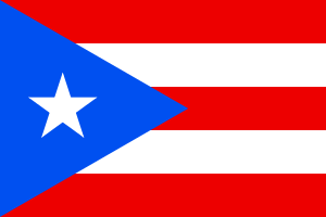 San Juan, Puerto Rico, United States
 Honolulu, Hawaii, United States
- Santa Barbara, California, United States
References
- ↑ Date of changing San Juan from a municipality to a city.
- ↑ "Cities". Quezon City, Philippines: Department of the Interior and Local Government. Retrieved 15 November 2012.
- ↑ Councilors of San Juan, Metro Manila.
- ↑ "An Update on the Earthquake Hazards and Risk Assessment of Greater Metropolitan Manila Area" (PDF). Philippine Institute of Volcanology and Seismology. November 14, 2013. Retrieved May 16, 2016.
- ↑ "Enhancing Risk Analysis Capacities for Flood, Tropical Cyclone Severe Wind and Earthquake for the Greater Metro Manila Area Component 5 – Earthquake Risk Analysis" (PDF). Philippine Institute of Volcanology and Seismology and Geoscience Australia. Retrieved May 16, 2016.
- 1 2 3 "NATIONAL CAPITAL REGION (NCR)". Census of Population (2015): Total Population by Province, City, Municipality and Barangay (Report). PSA. Retrieved 20 June 2016.
- ↑ Republic Act No. 9388 - Charter of the City of San Juan
- ↑ "Population and Annual Growth Rates for The Philippines and Its Regions, Provinces, and Highly Urbanized Cities" (PDF). 2010 Census and Housing Population. National Statistics Office. Retrieved 2012-11-07.
- ↑ http://cambridge.com.ph/greenhills/
- ↑ http://www.dominican.edu.ph/
- ↑ http://www.tfca.com.ph/
- ↑ sunstar.com.ph, Davao, San Juan cities ink sisterhood pact
External links
| Wikimedia Commons has media related to San Juan, Metro Manila. |
- Official Website of the City of San Juan, Metro Manila
 Geographic data related to San Juan, Metro Manila at OpenStreetMap
 |
Quezon City | | ||
| Manila | |
Quezon City | ||
| ||||
| | ||||
| Mandaluyong |