Pasig
| Pasig | ||
|---|---|---|
| Highly urbanized city | ||
| Lungsod ng Pasig | ||
|
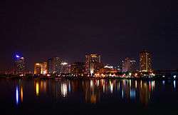
View of the Ortigas Center | ||
| ||
 Map of Metro Manila showing the location of Pasig | ||
.svg.png) Pasig Location within the Philippines | ||
| Coordinates: 14°34′30″N 121°05′00″E / 14.575°N 121.0833°ECoordinates: 14°34′30″N 121°05′00″E / 14.575°N 121.0833°E | ||
| Country | Philippines | |
| Region | National Capital Region (NCR) | |
| District | Lone District of Pasig City | |
| Founded | 1573 | |
| Cityhood | January 21, 1995 | |
| Barangays | 30 | |
| Government[1] | ||
| • Mayor | Robert "Bobby" Eusebio (Nacionalista) | |
| • Vice Mayor | Iyo Christian Caruncho Bernardo (Liberal) | |
| • Sangguniang Panlungsod |
Councilors
| |
| Area[2][3] | ||
| • Total | 31.46 km2 (12.15 sq mi) | |
| Population (2015 census)[4] | ||
| • Total | 755,300 | |
| • Density | 24,000/km2 (62,000/sq mi) | |
| Demonym(s) | Pasigueño | |
| Time zone | PST (UTC+8) | |
| ZIP code | see § Zip Codes | |
| Area code | +63 (0)02 | |
| Website |
www | |

Pasig is a city in the Philippines which was the former provincial capital of the province of Rizal prior to the formation of Metro Manila, the National Capital Region of the country of which it became a part. Located along the eastern border of Metro Manila, Pasig is bordered on the west by Quezon City and Mandaluyong; to the north by Marikina; to the south by Makati, Pateros, and Taguig; and to the east by Antipolo, the municipality of Cainta and Taytay in the province of Rizal.
A formerly rural settlement, Pasig is primarily residential and industrial, but has been becoming increasingly commercial in recent years, particularly after the construction of the Ortigas Center business district in its west. The city is also the see of the Roman Catholic Diocese of Pasig, making its cathedral (formerly the Immaculate Conception Cathedral) a landmark built around the same time as the town's foundation in 1573.
Etymology
The city's name Pasig was believed to have come from the old Sanskrit word "passid", or "sand", which refers to the tribal community beside the sandy edges of the river.[5] Some historians believed that El Pasig came from "Legaspi" (Miguel Lopez de Legazpi, the Basque explorer well known for being involved in the "Sanduguan", and was the first Governor-General of the Spanish East Indies.
It was pronounced "mapaksik" by the Pre-Hispanic Chinese inhabitants of Binondo, Manila ("Mabagsik" is Tagalog for "terrifying" - depicting the river's raging current during the typhoon season, causing massive floods on nearby towns and villages, destroying wide hectares of farmland, and even bringing huge amounts of logs and water lilies from Marikina River, Laguna de Bay, and San Juan River towards Colonial Manila). "Mapaksik" later became "Pah-sik", and was then changed to what is now "Pasig". It may have also come from the Tagalog word "dalampasigan", which means "riverbank".
According to Jose Villa Panganiban, the former director of the Institute of National Language, "Pasig" is another ancient Sanskrit word meaning "a waterway coming from one body of water to another," which briefly describes the river because its flow starts from Laguna de Bay, leading to Manila Bay.
History
Here lies a nearly-extinct creek that played an important role amidst the days of the Philippine Revolution. Long before the Spaniards had reached and discovered the "Ciudad-Municipal de Pasig" in the year 1573, a thriving Muslim community (Barangay) was already been established along this creek, ruled by Rajah Lontok and Dayang Kalangitan of the Sultanate-Kingdoms of Tondo and Namayan (the present-day Metro Manila).
The creek was given the name "Bitukang Manok" (Tagalog for "Chicken Gut"), due to the serpentine shape of its waterway. Among its early dwellers were Ethnic Malays, the Chinese from Southern China (with their origins dating back from the Ming Dynasty), and the Indigenous Tinguian nomads who migrated from the deep jungles of the Sierra Madre Mountain Range. The Bitukang Manok was once a principal tributary of the Marikina River. The Spanish colonizers called the creek "Rio de Pasig"; however, the natives still referred to it as the Bitukang Manok.
The first stretch of the Bitukang Manok became known as the "Pariancillo" (Estero de San Agustin), where its shoreline was once settled by Chinese and Malay merchants to trade their goods with the natives, until it developed up to the 1970s as the city's main public market. Likewise, the creek contributed enormously to the economic growth of Pasig during the Spanish Colonial Era, through irrigation of its wide paddy fields, and by being the progressive center of barter trade.
The Bitukang Manok, also known as the "Parian Creek", had once linked the Marikina River with the "Antipolo River". Before the Manggahan Floodway was built in 1986, The Parian Creek was actually connected to the Sapang Bato-Buli Creek (which serves as the boundary between Pasig's barangays Dela Paz-Manggahan-Rosario-Sta. Lucia and the Municipality of Cainta), the Kasibulan Creek (situated at Vista Verde, Brgy. San Isidro, Cainta), the Palanas Creek (leaving Antipolo through Brgy. Muntindilao), the Bulaw Creek (on Brgy. Mambungan, besides the Valley Golf and Country Club), and the Hinulugang Taktak Falls of Brgy. Dela Paz (fed by the Taktak Creek passing close to the Antipolo Town Square), thus being the detached and long-abandoned Antipolo River.
Since the early 1600s up to the period of Japanese Imperialism, over a thousand Catholic devotees coming from "Maynilad" (Manila), "Hacienda Pineda" (Pasay), "San Juan del Monte", "Hacienda de Mandaloyon" (Mandaluyong), "Hacienda Mariquina" (Marikina), "Barrio Pateros", "Pueblo de Tagig" (Taguig), and "San Pedro de Macati" (Makati), followed the trail of the Parian Creek to the Pilgrimage Cathedral on the mountainous pueblo of Antipolo, Morong (the present-day Rizal Province).
The Antipoleños and several locals from the far-reached barrios of "Poblacion de San Mateo", "Montalban" (Rodriguez), "Monte de Tanhai" (Tanay), "Santa Rosa-Oroquieta" (Teresa), and "Punta Ibayo" (Baras), had also navigated this freshwater creek once to go down to the vast "Kapatagan" (Rice plains) of lowland Pasig. Even the marian processions of the Our Lady of Peace and Good Voyage passed this route back and forth eleven times.
The creek has been also used during the British Occupation of Manila in 1762 to 1764 by the Royal British army, under the leadership of General William Draper and Vice Admiral Sir Samuel Cornish, 1st Baronet, to transport their red troops (and also the Sepoys they've brought from East India) upstream to take over the nearby forest-surrounded villages of Cainta and Taytay. They even did an ambush at the "Plaza Central" in front of the Pasig Cathedral, and turned the Roman Catholic Parish into their military headquarters, with the church's fortress-like "Campanilla" (belfry) serving as a watchtower against Spanish defenders sailing from the walled city of Intramuros via the Pasig River.
The Sepoys backstabbed their abusive British lieutenants and sided with the combined forces of the Spanish Conquistadors (assigned by the Governor-General Simon de Anda y Salazar), local rice farmers, fisherfolk, and even Chinese traders. After the British Invasion, the Sepoys remained and intermarried with Filipina women, and that explains the Hindu features of some of today's citizens of Pasig, especially Cainta and Taytay.
In 1742, an Augustinian friar named Fray Domingo Diaz, together with a group of wealthy "Mestizos de Sangley" (Chinese Mestizos) from Brgy. Sagad, ordered a construction of a marble, roof tile-covered bridge across the creek in the style of an oriental pagoda. It was named "Puente del Pariancillo", and a few years later, it changed to "Puente de Fray Felix Trillo", dedicated to the dynamic parochial curate of the Immaculate Conception Parish. Edmund Roberts visited Pasig in 1832.[6]
On the night of May 2, 1896, more than 300 revolutionary Katipuneros, led by the Supremo Gat. Andres Bonifacio, Emilio Jacinto and Pio Valenzuela, secretly gained access in this very creek aboard a fleet of seventeen "Bangkas" (canoes) to the old residence of a notable Valentin Cruz at Brgy. San Nicolas, and formed the "Asamblea Magna" (mass meeting).
Three months later on Saturday evening, 29 August, about less than 2,000 working-class Pasigueños (along with a hundred Chinese "Trabajadores" (laborers) from the failed Sangley revolts of 1639 and throughout the 17th century), armed with coconuts, machetes and bayoneted muskets (some were donated by the rich Ilustrado families, while many of those guns were looted from Spanish authorities), joined the Katipunan and made a surprise attack at the "Municipio del Gobernadorcillo" (the current site of the Pasig City Hall) and its adjacent garrison of the "Guardias Civil" (Civil Guard), situated near the border of barangays Maybunga and Caniogan.
That was the first and victorious rebellion ever accomplished by the Katipunan, and that particular event was popularly known as the "Nagsabado sa Pasig" (the Saturday Uprising on Pasig). After they had managed to successfully out-thrown the seat of Spanish government on Pasig, the Katipuneros fled immediately and advanced towards a "Sitio" located at the neighboring "Ciudad de San Juan" called "Pinaglabanan", and there they launched their second attempt to end the numerous cases of corruption made by the greedy Castilian "Encomenderos" (town officials) and "Hacienderos" (landlords), which shall be commemorated as the Battle of San Juan del Monte.
After World War II, the Bitukang Manok was slowly exposing its ecological downfall. It resulted in water pollution due to rational ignorance. The worst came to the Bitukang Manok in the late 1960s when the disappearing waterway, instead of being revived was totally separated from the Marikina River, and was converted into an open sewage ditch, with its original flow now moving in reverse towards the direction of the Napindan Channel (a portion of the Pasig River bordering between the barangays Kalawaan-Pinagbuhatan and Taguig City), to give way to public commercial facilities such as McDonald's.
On June 11, 1901, During the Philippine-American War, the province of Rizal was created through Act No. 137 of Philippine Commission. Pasig was incorporated into the province of Rizal, and was designated as the capital of the new province. In 1975, Pasig was carved out of Rizal province and became part of Metro Manila when the Metro Manila Commission (precursor of Metro Manila Authority and later Metropolitan Manila Development Authority) was created by Pres. Ferdinand Marcos through Presidential Decree 824.
In July 1994, Pasig was converted into a highly urbanized city through Republic Act 7829. And in December 1994, President Fidel V. Ramos signed it into law, which was ratified through a plebiscite on January 21, 1995.
On February 4, 2006, the ULTRA Stampede happened due to First Anniversary Celebration of ABS-CBN's Noontime Show, Wowowee because of the prizes that would be given away where 71 people died. The anniversary of the show would be held on PhilSports Arena but the event has been already canceled due to the tragedy.
Pasig was one of the areas strucked by high flood created by Typhoon Ondoy on September 26, 2009, which affected the Ortigas Avenue and the east city side of the Manggahan Floodway. It is the most destructive flood in Philippine history. Pasig is accessed by the Pasig River, wherein the waters of Marikina River channeled and the Manggahan Floodway routed to Laguna de Bay.
In the first week of August 2012, an intense rain by a monsoon created the 2012 Philippines flooding which affected again Pasig and particularly the National Capital Region (NCR), CALABARZON and southwest part of Luzon. The eight-day, nonstop monsoon rain strengthened by Typhoon Gener caused the Marikina River to overflow and destroyed the same places that were ruined by Typhoon Ondoy in 2009.
Barangays
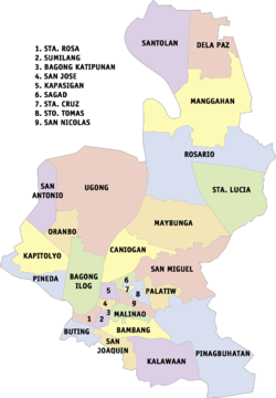
Pasig is politically subdivided into 30 barangays.[7] Its barangays are grouped into two districts for city council representation purposes.[8] The first district encompasses the southern and western sections of the city, while the second district encompasses the northern and eastern sections.
| Barangays | District | Population | Area (ha) | Density (/km²) |
|---|---|---|---|---|
| Bagong Ilog | 1st | 15,454 | 124.95 | 12,368.1 |
| Bagong Katipunan | 1st | 1,185 | 4.78 | 24,790.8 |
| Bambang | 1st | 19,258 | 38.41 | 50,138.0 |
| Buting | 1st | 9,073 | 20.33 | 44,628.6 |
| Caniogan | 1st | 21,769 | 167.94 | 12,962.4 |
| Dela Paza | 2nd | 13,047 | 199.79 | 6,530.4 |
| Kalawaan | 1st | 23,442 | 209.91 | 11,167.6 |
| Kapasigan | 1st | 6,569 | 21.15 | 31,059.1 |
| Kapitolyo | 1st | 10,451 | 95.24 | 10,973.3 |
| Malinao | 1st | 5,957 | 28.02 | 21,259.8 |
| Manggahanb | 2nd | 74,244 | 327.03 | 22,702.5 |
| Maybunga | 2nd | 35,627 | 177.37 | 20,086.3 |
| Oranbo | 1st | 4,395 | 43.61 | 10,078.0 |
| Palatiw | 1st | 16,929 | 24.24 | 69,839.1 |
| Pinagbuhatan | 2nd | 105,435 | 152.35 | 69,205.8 |
| Pineda | 1st | 15,013 | 79.85 | 18,801.5 |
| Rosario | 2nd | 50,690 | 414.54 | 12,228.0 |
| Sagád | 1st | 6,887 | 12.00 | 57,391.7 |
| San Antonio | 1st | 11,666 | 82.07 | 14,214.7 |
| San Joaquín | 1st | 12,498 | 45.07 | 27,730.2 |
| San José | 1st | 2,347 | 9.33 | 25,155.4 |
| San Miguel | 2nd | 30,069 | 80.05 | 37,562.8 |
| San Nicolas | 1st | 1,542 | 30.38 | 5,075.7 |
| Santa Cruz | 1st | 4,367 | 7.28 | 59,986.3 |
| Santa Lucia | 2nd | 40,553 | 178.31 | 22,743.0 |
| Santa Rosa | 1st | 1,515 | 12.06 | 12,562.2 |
| Santo Tomás | 1st | 6,375 | 10.43 | 61,121.8 |
| Santolan | 2nd | 43,286 | 199.25 | 21,724.5 |
| Sumilang | 1st | 5,392 | 17.18 | 31,385.3 |
| Ugong | 1st | 22,266 | 375.38 | 5,931.6 |
Notes:
- ^a Excludes 7,296 persons residing in the area disputed by Barangay San Isidro, Cainta, Rizal.
- ^b Includes population separately enumerated in the 2007 Census as Barangay Napico. Its creation was annulled by the Supreme Court on September 10, 1999.[9] Excludes 3,784 persons in the area disputed by Barangay San Isidro, Cainta, Rizal.
Demographics
| Population census of Pasig | |||||||||||||||||||||||||||||||||||||
|---|---|---|---|---|---|---|---|---|---|---|---|---|---|---|---|---|---|---|---|---|---|---|---|---|---|---|---|---|---|---|---|---|---|---|---|---|---|
|
| ||||||||||||||||||||||||||||||||||||
| Source: National Statistics Office[4][10] | |||||||||||||||||||||||||||||||||||||
Religion
Pasig is the headquarters of the Presbyterian Church of the Philippines.[11]
Economy
19th century
Historically, Pasig produced rice, fruit and sugarcane.[6]
Today
The western part of the city is where most of Pasig's financial resources are primarily concentrated. It includes numerous factories, warehouses, establishments and commercial facilities. Primarily they situated in the Ortigas Center, Pasig proper and along E. Rodriguez Jr. Avenue (C-5) and Ortigas Avenue. Real estate and commercial developments along Mercedes Avenue and other areas near the city center are developing. The eastern part was mostly dominated with residential areas but numerous commercial establishment are now developing along Marcos Highway. Per capita income (GDP) of Pasig is $12,032 per year. The barangay of San Antonio has the largest income in Pasig, second only to San Lorenzo of Makati as the largest single income-generated government unit in the Philippines. Arguably more significant western part of Pasig, east of the city of Mandaluyong and as part of the barangay of San Antonio, lies the Ortigas Center
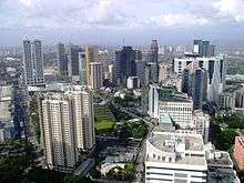
The Ortigas Center is one of the top business districts in the country, numerous high-rise office buildings, residential condominiums, commercial establishments, schools and malls are situated here. The University of Asia and the Pacific is located here. The head office of the Integrated Bar of the Philippines was also established here. The headquarters of the Philippine Stock Exchange, which is also home to one of trading floors of the country, is located along ADB Avenue. The headquarters of San Miguel Corporation, owner of one of the largest producer of beer in Asia, is located along San Miguel Avenue. Situated along Ortigas Avenue lies the Crowne Plaza, a five-star hotel near Robinsons Galleria.
Notable along Ortigas Avenue and E. Rodriguez Jr. Avenue (C-5) lies Frontera Verde, a newly privately owned development area which includes restaurants, pet shops, mall, park, village, office buildings and a small zoo. The shopping complex Tiendesitas was located here, a one spot hub that can rival the world-renowned Chatuchak market of Bangkok, Thailand. El-Pueblo, a colonial-themed commercial complex in Ortigas Center, provides new concept of cafes, restaurants and bars. Metrowalk (formerly Payanig), a commercial hub along Ortigas Avenue and Meralco Avenue, was established in 2005 near Ortigas Center which comprises shops, depot warehouses, stalls, restaurants and bars.
As of 2012, the revenue of the city totaled ₱7.22 billion.
Education
_-_back_view_(2015)_01.JPG)
Rizal High School (RHS) is located in Pasig. Named after the Philippine national hero José Rizal, it is one of the world's largest secondary education by student population. Formerly hailed in the Guinness World Records as the largest school by overall enrolled students, it is now surpassed by the City Montessori School (CMS) in Lucknow, India.
Pamantasan ng Lungsod ng Pasig, a local university in Kapasigan, offers degree courses for poor, bright and deserving residents of Pasig. It is established under the mayoralty of Vicente C. Eusebio in 1999.
Pasig City Science High School (PCSHS) is the first science high school in Pasig. It is located near Rainforest, a fully restored public resort and amusement park.
The University of Asia and the Pacific (UA&P) in Ortigas Center It traces back to the Center for Research and Communication (CRC) which started by two Harvard graduates in 1967 as an economic and social think-tank institution. Its spiritual and doctrinal formation is entrusted to Opus Dei.
Along C. Raymundo Avenue lies the national headquarters of Parents for Education Foundation, Inc. which runs schools such as PAREF Southridge School, PAREF Woodrose School, PAREF Northfield School, PAREF Rosehill School, and seven other schools.
St. Paul College Pasig was near the Philippine Institute of Sports Complex (ULTRA). It was established in 1970 as one of the educational institutions administered by the Congregation of the Sisters of St. Paul of Chartres.
The Pasig branch of Arellano University (Andres Bonifacio Campus) located in Caniogan also provides intermediate, secondary and vocational courses. The main branch is located in Manila.
Pasig Catholic College (PCC) is a private sectarian college located at the heart of Pasig. Established in 1913 as a small school managed by the CICM Fathers headed by Fr. Rouse Stephen Cebreros at the present Immaculate Conception Cathedral of Pasig, it is considered as the city's center of Catholic educational institution of the Roman Catholic Diocese of Pasig.
Situated at Mercedes Avenue lies La Consolacion College – Pasig. Founded by the Augustinian Sisters of Our Lady of Consolacion, it is one of the sister schools of La Consolacion College - Manila.
At the heart of city proper, lies Colegio del Buen Consejo (CBC). It is one of the oldest school in Pasig and one of the educational institutions promulgated by the Roman Catholic Diocese of Pasig.
La Immaculada Concepcion School (LICS) was situated in the outskirt of E. Caruncho Avenue near the Pasig's municipal capitol. It provides preschool, primary and secondary educations.
Saint Gabriel International School in Sandoval Avenue is the sister school of the Chinese-based Manila Xiamen International School. It provides Mandarin Chinese classes and ESL education for local and foreign students.
MFI Foundation Inc. (formerly Meralco Foundation Institute) was located near the Ortigas Center along Ortigas Avenue. Established in 1983, it serve to meet the industry's demand for middle-level technical manpower. As a partner of Philippine government's institution of the Technical Education and Skills Development Authority (Philippines) or TESDA, it provided two main programs in the Industrial Technician Program (ITP) which targets the youth and the Technical Training and MFI Training (formerly Testing Program) for skilled workers and professionals.
Sports
PhilSports Complex or the Philippine Institute of Sports Complex (formerly ULTRA) is a notable national sports complex of the Philippines. Located in Meralco Avenue, it is where the offices of the Philippine Sports Commission, Philippine Olympic Committee and some national sports associations are.
Transportation
Road network
Pasig is accessed by the following major roads:
- Ortigas Avenue
- E. Rodriguez Avenue, Jr. (C-5)
- Pasig Boulevard
- Julia Vargas Avenue
- Shaw Boulevard
- Meralco Avenue
- Pioneer Street
- Marcos Highway
- Amang Rodriguez Avenue
Water transportation
Pasig is the location of the east end of Pasig River. It is accessed by Pasig River Ferry Service with 7 stations named after the Barangays of the city beside the river, these are the following:
- Pineda
- San Joaquin
- Bambang
- Kalawaan
- Pinagbuhatan
- Maybunga
- Nagpayong
Bridges
Pasig is accessed by Pasig River and Marikina River. The city has only ten bridges:
- C-5 Bridge – spans Pasig River
- Manalo Bridge – spans Marikina River
- Rosario Bridge – spans Marikina River
- Sandoval Bridge – spans Marikina River
- Santa Rosa De Lima Bridge – spans Marikina River
- Julia Vargas Bridge (parallel bridges)- spans Marikina River
- Bambang Bridge – spans Napindan Channel
- Napindan Bridge – spans Napindan Channel
- Kalawaan Bridge – spans Pasig River
- Ortigas Bridge - spans Manggahan Floodway
- Manggahan Bridge (Daan Pasig Bridge)- spans Manggahan Floodway
- F B Legaspi Bridge - spans Manggahan Floodway
- Butting - Sumilang Bridge - spans Pasig River
Railway
This city is also served by Santolan Station of LRT-2 along Marcos Highway located in Pasig-Marikina Boundary where the depot is also located.
Long before the Manila Light Rail Transit System finally opened its services in Santolan in the Pasig-Marikina border in the early 2000s, Steam train services had once served those places in the past, even before World War II.
In Marikina, there is a street named "Daangbakal", also called by the names of "Shoe Avenue Extension", "Munding Avenue" and "Bagong Silang". There is also a similar "Daangbakal" in the San Mateo-Montalban (Rodriguez) area, and on the maps one can notice that the two roads should have been connected with each other. In fact, as the name suggests in Tagalog, these streets were once a single railway line. The two sides of the "Daangbakal" roads were once connected by a bridge in the San Mateo-Marikina border. However, as the railroad tracks have been largely ignored after the Japanese Occupation and was transformed into separate highways, the railway connection was abandoned.
The old railroad tracks, called the Marikina Line, was connected from Tutuban station in Manila, passing through Tramo (Brgy. Rosario, Pasig) coming all the way to the town of Marikina up to Montalban. On the northern end of the "Daangbakal" road in Montablan is a basketball court. That basketball court which stands today, surrounded by the Montalban Catholic Church and Cemetery, was once the railway station terminus of that particular line.
The present-day Santo Niño Elementary School in Marikina was said to be a train depot. And also it was said that a railroad station once stood in the Marikina City Sports Park.
The Marikina Line was completed in 1906, and continued its operation until 1936. It was said that the Japanese Imperial Army made use of this railway line during the Second World War. These railways were dismantled during the 1960s and were converted into ordinary roads.
Today, the citizens are dependent on Tricycles, Jeepneys, Taxis, FX, Buses, and AUV's which contribute to the everyday unusual and unbearable traffic of Metropolitan Manila. Even now, there is uncertainty in the Northrail project, which links Manila to the northern provinces of Luzon, because of corruption within the project's construction.
Aside from the Marikina Line, two other lines have existed before but are now removed permanently.
First is the Cavite Line, which passed through Paco, Parañaque, Bacoor and up to Naic, Cavite. Completed in 1908, its operation continued until 1936.
Second is the Antipolo Line, which passed through Santa Mesa, Mandaluyong, Pasig, Cainta, Taytay, up to Antipolo near the "Hinulugang Taktak" Falls. There is also a street named "Daangbakal" in Antipolo, where like the "Daangbakal" roads on Marikina and San Mateo, a railway line once existed. The railroad tracks also passed through what is now the Ortigas Avenue Extension. Its operation ceased in 1917.
Local government
List of mayors
- Aldrin Gersalia (1780s) (Gobernadorcillo)
- Resurrecion Balmaceda (1850)
- Don Rafael Umali (1852-1853, 1869-1870)
- Don Apolonio Santiago (1873-1884)
- Don Liberato Damian y Umali (1894)
- Hen. Valentin Cruz (1896)
- Don Pantalen Catanto (1897)
- Don Valentin Ruiz (1898)
- Felipe Benicio Gomez (1902–1904)
- Julio Raymundo (1904–1906)
- Jose Feliciano (1906–1909)
- Lupo Miguel (1909–1912)
- Francisco Reyes (1912–1915)
- Alejandro Ramos y Agullon (1915–1918)
- Don Fortunato Concepcion (1918–1921)
- Don/Dr. Sixto J. Antonio (1924–1935)
- Cipriano A. Raymundo (1936–1945)
- Francisco B. Legaspi (1945–1951)
- Cipriano A. Raymundo (1952–1955)
- Emiliano R. Caruncho, Jr. (1956–1986)
- Mario Raymundo (1986–1992)
- Vicente Eusebio (1992–2001; 2004–2007)
- Soledad Eusebio (2001–2004)
- Robert Eusebio (2007–2013; 2016–present)
- Maribel Andaya-Eusebio (2013–2016)
List of vice mayors
- Emiliano Santos (1956–1972)
- no vice mayor during martial law
- Vicente P. Eusebio (1980–1986)
- Boy Reyes (1986–1988) appointed vice mayor during revolutionary government
- Mike Cayton (1988–1992)
- Francisco S. De Guzman (1992-1995)
- Lorna Bernardo (1995–2004)
- Rosalio D. Martires (2004–2013)
- Christian "Iyo" Caruncho Bernardo (2013–present)
City seal
- The woman represents the Mutya ng Pasig, the idealism of perfection in all aspects that epitomizes loyalty, goodwill and splendor of the City of Pasig.
- The body of water on both sides of the woman is a suggestion of the Pasig River connecting two bodies of water, Laguna de Bay and Manila Bay both suggested by waves. Pasig is derived from a Hindu word meaning a body of water connecting two bodies of water.
- On the lower left portion is the Immaculate Conception Cathedral, one of the oldest edifices in the city. It is also the seat of the Roman Catholic Diocese of Pasig.
- On the lower right portion, it manifests prosperity and progress of the city.
Notable people
- Atoy Co, actor and former basketball player
- Marlou Aquino, former basketball player
- Doug Kramer, basketball player
- Rachelle Ann Go, singer and model
- Sam Milby, actor, singer, model in ABS-CBN
- Kean Cipriano, singer, actor and musician
- RJ Jimenez, Acoustic Singer, Pinoy Dream Academy Scholar
- Jerome Ponce, Newest Teen Age actor seen in Be Careful with my Heart
- Xian Lim, Chinito Actor, Model, Singer
- Rene Saguisag, Senator of the Republic elected in 1988
- Jovito Salonga, Former Senate President
- Vic Sotto, Artist, Host and TV Personality
- Raymond "Abra" Abracosa, Hip Hop Artist, Emcee, Singer
- Paolo Ballesteros, actor and TV Host, Eat Bulaga!
- Arjo Atayde, Filipino Actor, Star Magic, ABS-CBN
- Aljo Bendijo, Broadcast Journalist, PTV 4
Sister cities
- Marikina, Philippines
See also
- Legislative district of Pasig City
- Roman Catholic Diocese of Pasig
- Pasig City Museum
- Candaba, Pampanga, a place where there is a barangay named Pasig.
- Balabac, Palawan, a place where there is a barangay named Pasig.
- Lambunao, Iloilo, a place where there is a barangay named Pasig.
- Sara, Iloilo, a place where there is a barangay named Pasig.
References
- ↑ "Cities". Quezon City, Philippines: Department of the Interior and Local Government. Retrieved 15 November 2012.
- ↑ "An Update on the Earthquake Hazards and Risk Assessment of Greater Metropolitan Manila Area" (PDF). Philippine Institute of Volcanology and Seismology. November 14, 2013. Retrieved May 16, 2016.
- ↑ "Enhancing Risk Analysis Capacities for Flood, Tropical Cyclone Severe Wind and Earthquake for the Greater Metro Manila Area Component 5 – Earthquake Risk Analysis" (PDF). Philippine Institute of Volcanology and Seismology and Geoscience Australia. Retrieved May 16, 2016.
- 1 2 "NATIONAL CAPITAL REGION (NCR)". Census of Population (2015): Total Population by Province, City, Municipality and Barangay (Report). PSA. Retrieved 20 June 2016.
- ↑ Pasig Travel Tips and General Information
- 1 2 Roberts, Edmund (1837). Embassy to the Eastern Courts of Cochin-China, Siam, and Muscat. New York: Harper & Brothers. p. 60.
- ↑ NSCB Philippine Standard Geographic Codes – City of Pasig
- ↑ Synchronized National and Local Elections Law – Republic Act No. 7166, Section 3. Accessed on October 31, 2009.
- ↑ G.R. No. 125646. Accessed on October 20, 2009.
- ↑ "Population and Annual Growth Rates for The Philippines and Its Regions, Provinces, and Highly Urbanized Cities" (PDF). 2010 Census and Housing Population. National Statistics Office. Retrieved 2012-11-07.
- ↑ http://gapcp.org/?page_id=392
External links
| Wikimedia Commons has media related to Pasig. |
| Wikivoyage has a travel guide for Pasig. |
- Official website
 Geographic data related to Pasig at OpenStreetMap
 |
Quezon City | Marikina City | Cainta, Rizal | |
| Mandaluyong | |
Taytay, Rizal | ||
| ||||
| | ||||
| Makati City | Pateros | Taguig City |
.JPG)