Madison, Wisconsin, metropolitan statistical area
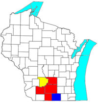
The Madison, WI Metropolitan Statistical Area, as defined by the United States Office of Management and Budget, is an area consisting of Columbia, Dane, Green, Rock, and Iowa counties[1] in Wisconsin, anchored by the city of Madison. As of the 2010 census, the MSA had a population of 568,593.
Definitions
The Madison-Janesville-Beloit Combined Statistical Area (CSA) is made up of six counties.[1] The statistical area includes two metropolitan areas and one micropolitan area. As of the 2014, the CSA had a population of 858,354.
- Metropolitan Statistical Areas (MSAs)
- Madison (Columbia, Dane, Green, and Iowa counties)
- Janesville-Beloit (Rock County)
- Micropolitan Statistical Areas (μSAs)
- Baraboo (Sauk County)
| Historical population | |||
|---|---|---|---|
| Census | Pop. | %± | |
| 1840 | 7,028 | — | |
| 1850 | 69,416 | 887.7% | |
| 1860 | 162,791 | 134.5% | |
| 1870 | 192,943 | 18.5% | |
| 1880 | 194,207 | 0.7% | |
| 1890 | 206,572 | 6.4% | |
| 1900 | 230,598 | 11.6% | |
| 1910 | 241,109 | 4.6% | |
| 1920 | 261,670 | 8.5% | |
| 1930 | 291,385 | 11.4% | |
| 1940 | 320,791 | 10.1% | |
| 1950 | 378,060 | 17.9% | |
| 1960 | 454,377 | 20.2% | |
| 1970 | 547,469 | 20.5% | |
| 1980 | 599,470 | 9.5% | |
| 1990 | 649,147 | 8.3% | |
| 2000 | 742,953 | 14.5% | |
| 2010 | 827,742 | 11.4% | |
| Est. 2015 | 866,475 | [2] | 4.7% |
| U.S. Decennial Census[3] 1790–1960[4] 1900–1990[5] 1990–2000[6] 2010–2014[7] | |||
The CSA totals are the totals of all the counties listed above, regardless of whether they were included in the Combined Statistical Area at the time.
Counties
Communities
Cities
- Columbus
- Dodgeville
- Fitchburg
- Lodi
- Madison (Principal city)
- Middleton
- Mineral Point
- Monona
- Portage
- Stoughton
- Sun Prairie
- Verona
- Wisconsin Dells (partial)
Villages
|
|
Census-designated places
- Lake Wisconsin (partial)
- Windsor
Unincorporated places
- Ashton
- Basco
- East Bristol
- Helena
- Hope
- Morrisonville
- Mount Vernon
- North Bristol
- Paoli
- Pine Bluff
- Utica
Towns
Columbia County
Dane County
Iowa County
Demographics
As of the census[8] of 2000, there were 501,774 people, 202,687 households, and 121,171 families residing within the MSA. The racial makeup of the MSA was 90.26% White, 3.50% African American, 0.32% Native American, 2.99% Asian, 0.03% Pacific Islander, 1.27% from other races, and 1.63% from two or more races. Hispanic or Latino of any race were 3.05% of the population.
The median income for a household in the MSA was $45,602, and the median income for a family was $55,159. Males had a median income of $35,250 versus $26,322 for females. The per capita income for the MSA was $21,832.
See also
References
- 1 2 "OMB Bulletin No. 13-01: Revised Delineations of Metropolitan Statistical Areas, Micropolitan Statistical Areas, and Combined Statistical Areas, and Guidance on Uses of the Delineations of These Areas" (PDF). United States Office of Management and Budget. February 28, 2013. Retrieved May 22, 2015.
- ↑ "County Totals Dataset: Population, Population Change and Estimated Components of Population Change: April 1, 2010 to July 1, 2015". Retrieved July 2, 2016.
- ↑ "U.S. Decennial Census". United States Census Bureau. Retrieved August 9, 2015.
- ↑ "Historical Census Browser". University of Virginia Library. Retrieved August 9, 2015.
- ↑ Forstall, Richard L., ed. (March 27, 1995). "Population of Counties by Decennial Census: 1900 to 1990". United States Census Bureau. Retrieved August 9, 2015.
- ↑ "Census 2000 PHC-T-4. Ranking Tables for Counties: 1990 and 2000" (PDF). United States Census Bureau. April 2, 2001. Retrieved August 9, 2015.
- ↑ "State & County QuickFacts". United States Census Bureau. Retrieved January 23, 2014.
- ↑ "American FactFinder". United States Census Bureau. Retrieved 2008-01-31.
| Surrounding communities |
|  | ||||||
|---|---|---|---|---|---|---|---|---|
| Counties | ||||||||