Mandya district
| Mandya district ಮಂಡ್ಯ ಜಿಲ್ಲೆ | |
|---|---|
| district | |
|
| |
| Nickname(s): Sakkare Nadu | |
| Coordinates: 12°31′N 76°54′E / 12.52°N 76.9°ECoordinates: 12°31′N 76°54′E / 12.52°N 76.9°E | |
| Country |
|
| State |
|
| Region | Bayaluseeme |
| Division | Mysore Division |
| Established | 1 July 1939[1] |
| Headquarters | Mandya |
| Talukas | Mandya, Malavalli, Maddur, Nagamangala, Krishnarajpet, Pandavapura, Srirangapatna |
| Government | |
| • Deputy Commissioner | ZIYAULLAH S IAS |
| Area[2] | |
| • Total | 4,961 km2 (1,915 sq mi) |
| Population (2011)[3] | |
| • Total | 1,805,769 |
| • Density | 360/km2 (940/sq mi) |
| Languages | |
| • Official | Kannada |
| Time zone | IST (UTC+5:30) |
| ISO 3166 code | IN-KA-MA |
| Vehicle registration | KA-11,(KA-54 nagamangala) |
| Sex ratio | 1.015 ♂/♀ |
| Literacy | 70.40 % |
| Lok Sabha constituency | Mandya Lok Sabha constituency |
| Climate | Tropical Semi-arid (Köppen) |
| Precipitation | 691 millimetres (27.2 in) |
| Avg. summer temperature | 35 °C (95 °F) |
| Avg. winter temperature | 16 °C (61 °F) |
| Website |
mandya |
Mandya District is an administrative district of Karnataka, India. Mandya District borders on the south by Mysore District, on the west by Hassan District, on the north by Tumkur District and on the east by Ramanagar district. The district was formed in the year 1939.
The main town is in Mandya District is Mandya. As of 2011, the district population was 1,808,680 of which 16.03% was urban.[4]
Etymology
Mandya district gets its name from the city of Mandya which is also the headquarters of the district. Although the widely purported mythical story about the name is that the region is named after a sage called Maandavya, but scholars and academicians have stated based on ancient inscription that this region was referred as 'Man-ta-ya' (ಮಂಟಯ), meaning a habitat preceding a civilization or roughly an ancient abode ("ಆವಾಸಸ್ತಾನ, ಅತ್ಯಂತ ಪ್ರಾಚೀನವಾದ ನಾಗರೀಕತೆಗೂ ಮುನ್ನಿನ ಜನವಸತಿ ಎಂಬ ಅರ್ಥವಿದೆ". "ಸುವರ್ಣ ಮಂಡ್ಯ" ಪುಸ್ತಕದಿಂದ - ಸಂಪಾದಕರು ದೇ. ಜವಾರೇಗೌಡ (ದೇಜಗೌ)). And gradually it became Mandya.
Mandya's history is closely related to the history of the old Mysore State, which included the present district of Mandya and areas around the Cauvery Basin. Ruled successively by the kings of the Ganga dynasty and then the Cholas and the Hoysalas, the area was annexed by the rulers of Vijayanagara in 1346. After the cruel battle of 1565 When the Vijayanagara king was defeated by the combined power of the Sultans of the Deccan, the Vijayanagara Empire began to lose its power and extent. The Wodeyars of Mysore gradually grew in importance. Before long, they had established their own rule over a large part of South India which included all of old Mysore, parts of the present Tamil Nadu and the districts of Dakshina Kannada and Dharwar, with Srirangapatna as their capital.
The power of the Wodeyars was more or less unchallenged till 1761 when Hyder Ali, one of their generals rose to great strength and overcame them. Between then and 1799 when Hyder's son Tipu was defeated by the British, the area was under constant crossfire.
Finally on 30 June 1 799, Krishnaraja Wodeyar Ill, a descendant of the ancient royal house was placed on the throne o Mysore by the British while Srirangapatna became the property of the victorious East India Company. The dynastic rule of Wodeyars thereafter ended only with the establishment of democracy in free India. The district of Mandya itself constituted in 1939 as an administrative unit with seven taluks has remained unchanged to this day
The district covers an area of about 4850.8 square kilometers, about 1/40th of the area of the whole state. The area is plain except for a few outcrops of rocks that stand out as ridges and an extension of the Biligirirangana range of mountains in the southeast. Perhaps among Mandya's greatest assets are its four rivers, the Cauvery, Hemavati, lokapavani and Shimsha that give the district both religious importance and scenic beauty.
Although none of the rivers are navigable, they form picturesque waterfalls wherever the lie of the land permits it and the small shrines on riverbanks are testimony to the deep belief in India that rivers themselves are holy
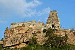
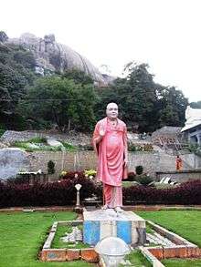
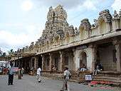
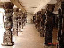
Tourist attractions

_at_Hohaholalu_in_Mandya_district.JPG)
_at_Kikkeri%2C_Mandya_district.JPG)
_at_Kambadahalli.JPG)


The importance of the district's headquarters town, Mandya, grew with the establishment, in January 1933, of the Mandya Sugar Factory with an authorized capital of Rs. 20 lakhs – a great amount those days. Predictably the sugar factory is now one of the biggest in India.
Mandya town also contains the stately Janardhanaswami temple whose principal deity holding the traditional Shanka and Chakra i5 flanked by Sridevi and Bhudevi on either side. The temple's gopura recently renovated adds to the aesthetics of the temple. The annual car festival is held in April–May every year.
- Malavalli
- Cauvery Water Falls
- Bhimeshwari
- Pandavapura
- Kuntibetta
- Melkote
- Tirumalasagara
- Krishnarajapet
- Kikkeri
- Basaralu
- Shivapura
- Kokkare-Bellur
- Bluff
- Muttati
- Nagamangala
- Srirangapatna
- Sangama
- Karighatta
- Ranganathittu
- Krishnarajasagar Dam
Power
Infrastructure of electric power, which is the lifeline of domestic, agricultural and industrial sectors today, is available in the district as follows:
Hydro-Electric power project at Shivanasamudram, the first hydro electric power project in India established in 1902, generates about 42 Megawatts(6x3+4x6MW) electric power.
Hydro-Electric power project at Shimsha established in 1940, generates about 17.2 MW (2x8.6MW)electric power.
Keelara power Pvt. Ltd., Hydro electric power project at Keelara, Mandya Taluk is commissioned and functioning with 2 MW capacity.
Malavalli Power Plant Private Limited which is an Agri-based project has a generating capacity of 4.5MW
Atria Power Corporation Ltd., has obtained clearances for mini hydro Electric power project at Shimsha with generating capacity of 12 MW. This project is under implementation
Geography
Mandya district is located between north latitude 12°13' to 13°04' N and east longitude 76°19' to 77°20' E.[5] It is bounded by Mysore district to the west and southwest, Tumkur district to the northeast, Chamrajnagar district to the south, Hassan district to the northwest, and Ramanagar district to the east. It has an area of 4,961 square kilometres (1,915 sq mi). The administrative center of Mandya District is Mandya City.
Rivers
Mandya District has five important rivers: Kaveri River and four tributaries main Hemavathi, Shimsha, Lokapavani, Veeravaishnavi.[6]
Administrative divisions
Mandya district consists of 7 taluks grouped under 2 subdivisions. The Mandya subdivision comprises Mandya, Maddur and Malavalli taluks and the Pandavapura subdivision comprises Pandavapura, Srirangapatna, Nagamangala and Krishnarajpet Taluks.[5]
Economy
Since Mandya is located on the banks of the river Cauvery, agriculture is the dominanat occupation and is the single largest contributor to its economy . The main crops grown are Paddy, Sugarcane, Jowar, Maize, Cotton, Banana, Ragi, Coconut, Pulses (predominantly horse gram and to some extent tur, cowpea, green gram, black gram, avare), Vegetables etc.[5]
Transportation
Mandya district has an extenstive road network. NH 48 and NH 209 passes through the district. The road network in the district includes 73 kilometres (45 mi) of National Highways, 467 kilometres (290 mi) of State Highways and 2,968 kilometres (1,844 mi) of Major district roads.[7] Mandya belongs to "South Western Railways" of "Indian Railways". Mandya has many railway stations which are listed below:[8]
Demographics
According to the 2011 census Mandya district has a population of 1,808,680,[9] roughly equal to the nation of The Gambia[10] or the US state of Nebraska.[11] This gives it a ranking of 263rd in India (out of a total of 640).[9] The district has a population density of 365 inhabitants per square kilometre (950/sq mi) .[9] Its population growth rate over the decade 2001-2011 was 2.55%.[9] Mandya has a sex ratio of 989 females for every 1000 males,[9] and a literacy rate of 70.14%.[9]
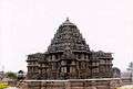
Gallery
-
The Cheluvnarayanaswami temple at Melkote
-
Mantapa in Vijayanagara style, Cheluvanarayanaswami temple in at Melkote
-
Lakshminarayana Temple at Hosaholalu
-
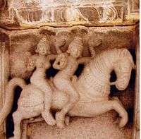
Ceiling art at Panchakuta Basadi at Kambadahalli
-

View of Narasimha Swamy Temple at Melkote
Celebrities from Mandya
- S M Krishna - External affairs minister of Govt of India, Former chief minister of Karnataka state & former Governor of Maharashtra state.
- Ambarish - Popular Kannada film Star, and a Member of Parliament.
- B.S.Yediyurappa- Karnataka's 25th chief minister,yadiyurappa born in Bookanakere, K.R.Pete taluk
- Ramya - popular south Indian actress and she was the youngest MP of India in the 15 loksabha
References
- ↑ "District Profile". Department of State Education Research and Training. Retrieved 6 January 2011.
- ↑ "Know India - Karnataka". Government of India. Retrieved 6 January 2011.
- ↑ "District Statistics". Official Website of Mandya district. Retrieved 6 January 2011.
- ↑ India Census Map
- 1 2 3 "Ground Water Information Booklet" (PDF). Central Ground Water Board. Retrieved 7 January 2011.
- ↑ "Mandya District at a glance". Mandya City Council. Retrieved 2006-11-10.
- ↑ "District wise details of Road length in Karnataka". Karnataka Public Works Department. Retrieved 9 January 2011.
- ↑ Archived 21 July 2011 at the Wayback Machine.
- 1 2 3 4 5 6 "District Census 2011". Census2011.co.in. 2011. Retrieved 2011-09-30.
- ↑ US Directorate of Intelligence. "Country Comparison:Population". Retrieved 2011-10-01.
Gambia, The 1,797,860 July 2011 est.
- ↑ "2010 Resident Population Data". U. S. Census Bureau. Retrieved 2011-09-30.
Nebraska 1,826,341
External links
| Wikimedia Commons has media related to Mandya district. |
- Official website of Mandya district
 Mandya (district) travel guide from Wikivoyage
- Map of Mandya District
- Mandya District profile
- Mandya City Council -Mandya District at a glance
 |
Hassan district | Tumkur district | | |
| |
Ramanagar district | |||
| ||||
| | ||||
| Mysore district | Chamrajnagar district |