March 1990 Central United States tornado outbreak
 Map of confirmed tornadoes in the outbreak | |
| Type | Tornado outbreak |
|---|---|
| Duration | March 11–13, 1990 |
| Tornadoes confirmed | 64 confirmed |
| Max rating1 | F5 tornado |
| Duration of tornado outbreak2 | 2 days, 5 hours |
| Damage | $543.408 million |
| Casualties | 2 deaths, 89 injuries |
| Areas affected | Midwestern United States, United States Great Plains |
|
1Most severe tornado damage; see Fujita scale 2Time from first tornado to last tornado | |
The March 1990 Central United States tornado outbreak affected portions of the United States Great Plains and Midwest regions from Iowa to Texas from March 11 to March 13, 1990. The outbreak produced at least 64 tornadoes across the region, including four violent tornadoes; two tornadoes, which touched down north and west of Wichita, Kansas, were both rated F5, including the tornado that struck Hesston. In Nebraska, several strong tornadoes touched down across the southern and central portion of the state, including an F4 that traveled for 131 miles (211 km). Two people were killed in the outbreak, one apiece by the two F5s in Kansas.
Overview
The Central United States tornado outbreak of March 13, 1990, was one of the most violent outbreaks ever documented in March (second only to the Palm Sunday tornado outbreak of 1920 in terms of violent tornadoes and the March 2006 Tornado Outbreak Sequence in terms of the total number of tornadoes reported). Numerous tornadoes touched down across Nebraska, Kansas, Oklahoma, and Iowa. Two tornadic thunderstorms with exceptional life spans/tornado families were observed, one of which produced an F4 tornado in eastern Nebraska that was on the ground for over 100 miles (160 km). The other produced an extensive tornado family in southern Kansas that included two F5 tornadoes. The first of these struck the town of Hesston, Kansas, and was one of the most photographed and documented violent tornadoes in history.
Confirmed tornadoes
| F0 | F1 | F2 | F3 | F4 | F5 | Total |
|---|---|---|---|---|---|---|
| 12 | 25 | 13 | 10 | 2 | 2 | 64 |
(based on NOAA Storm Data)
March 11 event
| F# | Location | County | Time (UTC) | Path length | Damage | |
|---|---|---|---|---|---|---|
| Kansas | ||||||
| F0 | Reno | Reno | 2300 | 0.1 miles (160 m) | ||
| F1 | Rice | Rice | 2315 | 14 miles (23 km) | ||
| Sources: NOAA Storm Data Tornado History Project - Storm Data, March 11, 1990 | ||||||
March 12 event
| F# | Location | County | Time (UTC) | Path length | Damage | |
|---|---|---|---|---|---|---|
| Iowa | ||||||
| F0 | NW of Sawyer | Lee | 0440 | 0.2 miles (0.32 km) | ||
| Kansas | ||||||
| F1 | SE of Topeka | Shawnee, Douglas | 0549 | 5 miles (8.0 km) | ||
| F1 | W of McClouth | Jefferson | 0610 | 3 miles (4.8 km) | ||
| Sources: NOAA Storm Data Tornado History Project - Storm Data - March 12, 1990 | ||||||
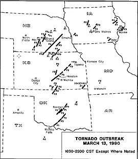
March 13 event
| F# | Location | County | Time (UTC) | Path length | Damage | |
|---|---|---|---|---|---|---|
| Kansas | ||||||
| F1 | NW of Jetmore | Hodgeman | 0836 | 1 mile (1.6 km) | ||
| F5 | Castleton to Hesston | Reno, Harvey, McPherson | 2234 | 48 miles (77 km) | 1 death - See section on this tornado | |
| F1 | E of Thornburg | Smith | 2248 | 13 miles (21 km) | ||
| F1 | NE of Esbon | Jewell | 2300 | 1.5 miles (2.4 km) | ||
| F5 | Goessel to NE of Hillsboro | Harvey, McPherson, Marion | 2330 | 22.0 miles (35.4 km) | 1 death - See section on this tornado | |
| F0 | SW of Portland | Sumner | 0004 | 0.1 miles (160 m) | ||
| F0 | N of Conway Springs | Sumner | 0012 | 0.1 miles (160 m) | ||
| F2 | W of Pilsen to NW of Volland | Marion, Morris, Geary, Wabaunsee | 0015 | 55 miles (89 km) | Tornado damaged many farms and destroyed four homes on the southern side of Dwight. Tornado was spawned by the same supercell that produced the Hesston and Goessel tornadoes. | |
| F1 | SW of Webber | Jewell | 0020 | 5 miles (8.0 km) | ||
| F1 | S of Danville | Harper | 0035 | 12 miles (19 km) | ||
| F1 | E of Randall | Jewell, Cloud, Republic | 0045 | 13 miles (21 km) | ||
| F3 | W of Moundridge | Reno, Harvey, McPherson | 0055 | 18 miles (29 km) | A farm and three homes were destroyed. Caused $275,000 in damage. | |
| F2 | W of Belleville | Republic | 0100 | 15 miles (24 km) | Several farmhouses sustained extensive damage. | |
| F0 | S of Belleville | Republic | 0116 | 0.5 miles (0.80 km) | ||
| F0 | Salina | Saline | 0150 | 0.2 miles (320 m) | ||
| F1 | E of Wamego | Pottawatomie | 0203 | 2 miles (3.2 km) | ||
| F0 | S of Concordia | Cloud | 0240 | 0.2 miles (320 m) | ||
| F1 | S of Chetopa | Labette | 0645 | 2 miles (3.2 km) | ||
| Iowa | ||||||
| F1 | N of Stiles to SE of Floris | Davis | 2132 | 14 miles (23 km) | ||
| F0 | Bettendorf area | Scott | 2231 | 0.3 miles (480 m) | ||
| F0 | E of LeClaire | Scott | 2242 | 0.2 miles (320 m) | ||
| F3 | E of LeClaire to SE of Albany, IL | Scott, Rock Island (IL), Whiteside (IL) | 2245 | 15.5 miles (24.9 km) | Multiple-vortex tornado caused major damage in the Cordova and Port Byron areas. 12 homes were heavily damaged or destroyed, and 26 others sustained lesser damage. One man broke his leg when he was blown off of a scaffold at Cordova Nuclear Plant. | |
| F4 | Prairieburg to Worthington | Linn, Jones, Delaware, Dubuque | 2253 | 19 miles (31 km) | In Worthington, 39 homes and businesses were damaged or destroyed. 13 farms were destroyed as well. Tornado was a half-mile wide at times. | |
| F1 | NE of LeClaire | Scott, Clinton | 2242 | 13 miles (21 km) | ||
| F1 | Monticello area | Jones | 2308 | 6 miles (9.7 km) | ||
| F1 | NE of Crescent | Pottawattamie | 2242 | 8 miles (13 km) | ||
| F1 | S of Holy Cross | Dubuque | 2355 | 3 miles (4.8 km) | ||
| F0 | NE of Ortonville | Dallas | 0120 | 0.1 miles (160 m) | ||
| F2 | Ogden to E of Stanhope | Boone, Hamilton | 0125 | 22 miles (35 km) | Tornado killed livestock and destroyed several outbuildings. Caused $616,000 in damage. | |
| F1 | E of Ridgeport | Boone | 0135 | 1 mile (1.6 km) | ||
| F2 | Ankeny to S of Maxwell | Polk, Story | 0155 | 15 miles (24 km) | Rain-wrapped tornado severely damaged 20 homes in Ankeny, with 16 others sustaining lesser damage. A condominium lost part of its roof, which was thrown onto I-35, resulting in a major car accident. At least a dozen other cars were blown off of the interstate by the tornado. Caused $2,000,000 in damage and injured 15 people. | |
| F3 | E of Fernald | Story | 0236 | 9 miles (14 km) | A tractor-trailer was lifted and thrown into a ditch, injuring the driver. Multiple buildings were damaged or destroyed at a farm as well. Rated F2 by Grazulis. | |
| Oklahoma | ||||||
| F2 | NW of Bradley to E of Norman | Grady, McClain, Cleveland | 2244 | 28 miles (45 km) | Two mobile homes were destroyed and frame homes were damaged near the beginning of the path. The tornado crossed into McClain County and destroyed eight additional mobile homes before clipping the north side of Washington, destroying a trailer and the second story of a house. The tornado then struck Noble before dissipating. In Noble, multiple homes sustained roof and structural damage, and an apartment building lost part of its roof. Tractor-trailers and a mobile home were overturned. The high school lost its press box, scoreboard, and several light poles. One person was injured. | |
| F3 | SE of Hawley to NE of Wakita | Grant | 2315 | 19 miles (31 km) | One house sustained major damage and another lost its roof. | |
| F2 | W of Criner to W of Slaughterville | McClain, Cleveland | 2331 | 18 miles (29 km) | Trailers and outbuildings were damaged and many trees were uprooted. Rated F1 by Grazulis. | |
| F1 | NE of Norman | Cleveland | 2353 | 5 miles (8.0 km) | ||
| F3 | NE of Wakita to SW of Mayfield, KS | Grant, Sumner (KS) | 2354 | 22 miles (35 km) | Caused tree damage in Oklahoma before crossing into Kansas, where five homes were damaged. | |
| F2 | SW of Stella to SE of Jacktown | Cleveland, Pottawatomie, Lincoln | 2359 | 19 miles (31 km) | At the beginning of the path, a mobile home was destroyed in Stella, resulting in a serious injury. A barn was destroyed, a house was unroofed, and three trailers were damaged elsewhere along the path. A mobile home was destroyed near Meeker before the tornado dissipated. | |
| F1 | W of Waurika to SW of Loco | Jefferson, Stephens | 0001 | 21 miles (34 km) | ||
| F3 | SW of Loco to NW of Alpers | Jefferson, Stephens, Carter, Garvin | 0058 | 22 miles (35 km) | Tornado caused major damage in and around Ratliff City. Five mobile homes were destroyed and a motor home was rolled 100 feet. A five-ton crane was blown over, several vehicles were damaged, and debris was found up to a mile away. Caused $750,000 in damage and injured one person. | |
| F2 | NE of Tatums to NE of Paul's Valley | Garvin | 0150 | 28 miles (45 km) | In Pauls Valley, a farm implement company had its roof torn off, and a civic club building lost part of its roof. Barns were destroyed outside of town as well. | |
| F2 | NE of Edna | Creek, Okmulgee | 0210 | 9 miles (14 km) | Several barns were destroyed and 14 power poles were snapped. Caused $75,000 in damage. | |
| Nebraska | ||||||
| F1 | NW of Shelton | Buffalo | 2245 | 1 mile (1.6 km) | ||
| F3 | NW of Minden to S of Cairo | Kearney, Buffalo, Hall | 2300 | 32 miles (51 km) | Numerous outbuildings were destroyed, trees were uprooted, and a county bridge was destroyed. Five farmsteads were heavily damaged as well. | |
| F4 | S of Red Cloud to E of Schuyler | Webster, Nuckolls, Clay, Fillmore, York, Seward, Butler, Colfax | 2305 | 131 miles (211 km) | This was either an extremely long-tracked tornado or a tornado family. Near Red Cloud, a farmhouse was completely "wiped out". The tornado moved into Nuckolls County and struck Lawrence, where 8 homes were destroyed and 45 others were damaged. Crossing into Clay County, the tornado struck Sutton, where one business was destroyed and 11 others were damaged. 49 homes in Sutton were damaged, and a truck and a police car were flipped. 20 farms were damaged in rural areas nearby. The tornado downed trees and power lines in Fillmore County before crossing into York County. A farmhouse was destroyed near McCool Junction. South of York, the tornado destroyed another farmhouse, heavily damaged a gas station and convenience store, tore the roof off of a motel, and destroyed two trucks. A dozen farms were damaged in York County, and about 10,000 geese were killed. 57 railroad cars were derailed near Waco before the tornado crossed into Seward County, where trees and power lines were damaged. The tornado then crossed into Butler County and passed near David City, impacting numerous farmsteads. 35 homes and 155 other structures were damaged or destroyed near David City, and about 1,200 livestock were killed or injured. The tornado then moved into Colfax County, damaging four farms near Schuyler before dissipating. A total of nine people were injured. | |
| F2 | E of Sacramento | Kearney | 2320 | 8 miles (13 km) | Several farms sustained extensive damage with livestock killed, and outbuildings and irrigation pivots destroyed. | |
| F2 | S of Wood River | Adams, Hall | 2325 | 9 miles (14 km) | Two farms were hit, with a farmhouse sustaining extensive damage at one of them. Outbuildings, grain bins, and two barns were destroyed. | |
| F0 | N of Kearney | Buffalo | 2335 | 0.1 miles (160 m) | ||
| F3 | N of Alda to NW of Archer | Hall, Howard, Merrick | 2344 | 27 miles (43 km) | Five mobile homes were destroyed, and other homes sustained minor damage. 15 train cars were derailed near an Army Ordinance Plant, and 47 others were derailed near Grand Island. Several farms were damaged, some extensively with loss of cattle. | |
| F2 | W of Fullerton | Merrick, Nance | 0023 | 13 miles (21 km) | Ten farms were damaged, with farmhouses damaged at four of them. | |
| F1 | NE of Boone | Boone | 0025 | 1.5 miles (2.4 km) | ||
| F1 | SE of Fullerton | Nance | 0030 | 2 miles (3.2 km) | ||
| F1 | Newman Grove area | Madison | 0045 | 0.2 miles (320 m) | ||
| F1 | SE of Battle Creek | Madison | 0130 | 0.6 miles (0.97 km) | ||
| F3 | N of Carleton to SE of Exeter | Thayer, Fillmore | 0145 | 25 miles (40 km) | A large hog facility and outbuildings were destroyed. A mobile home was destroyed as well. Rated F2 by Grazulis | |
| F3 | NE of Chester | Thayer | 0145 | 13 miles (21 km) | Tornado clipped Chester, where trees, outbuildings and propane tanks were damaged. Several farmsteads were damaged outside of town as well. Rated F2 by Grazulis. | |
| F1 | N of Bancroft | Thurston | 0401 | 1.5 miles (2.4 km) | ||
| Texas | ||||||
| F0 | NE of Lusk | Throckmorton | 2330 | 0.2 miles (320 m) | ||
| Missouri | ||||||
| F2 | SE of Pleasant Hope | Polk | 0330 | 2 miles (3.2 km) | Five homes and 16 barns were damaged. | |
| Sources: NOAA Storm Data Tornado History Project Storm Data - March 13, 1990[1] | ||||||
The Hesston and Goessel tornado family

The tornadoes that struck Hesston and Goessel were both spawned by the same supercell thunderstorm. They were part of what is known as a tornado family; a family that included several additional touchdowns after the Goessel storm dissipated.[2]
The first tornado of the Hesston storm touched down at approximately 4:34 p.m. CDT just to the northeast of Pretty Prairie. It was initially between 200 and 500 yards in diameter, and caused minimal (F1-F2) damage as it churned between Castleton and the Cheney Reservoir. Photographic evidence suggests significant widening as the tornado approached Haven and the Arkansas River. The damage path ranged between 1/2 and 3/4 miles near Haven, and several homes were completely demolished indicating F4 damage. Had the tornado moved through a more populated area in this stage of its life, it is likely that it would have caused much more dramatic damage. Fairly constant F3 damage was produced from Haven to Burrton and to the Little Arkansas River. The path width remained over 0.5 miles (0.80 km) in diameter.
Northeast of the Little Arkansas, the track abruptly decreased in width from 0.5 miles (0.80 km) to just over 300 yards (270 m). Photographs suggest what appears to be a re-organization of the tornadic circulation; initially a wedge like appearance, the funnel quickly became tall and narrow. The most significant damage was done in this stage, however. The tornado plowed into the town of Hesston, just northwest of Newton on I-135. A total of 226 homes and 21 businesses were destroyed, and several were swept completely from their foundations. Portions of the damage path in Hesston were rated F5. 20 farms were torn apart in rural areas outside of town. Light debris from Hesston was found 115 miles (185 km) away in Nebraska. One person died and 59 people were injured.
The series of events that occurred as the tornado moved past the Hesston area were most interesting. Eyewitness accounts observed the touchdown of an additional tornado just to the north. This is consistent with models of what is known as a "tornado handoff", in which an old mesocyclone and tornado occlude as a new mesocyclone and tornado further downwind becomes dominant.[3] Over the course of a few miles, the new tornado intensified and the original one abruptly constricted and apparently became a satellite tornado to the new tornado. Eventually, the Hesston tornado (after traveling nearly 48 miles (77 km)) occluded and merged with the new tornado, and the supercell began to re-intensify. The new tornado rapidly became very large, and violent damage was produced by the second tornado in Marion County. Several homes were again completely demolished and swept away and one additional fatality was reported. The tornado produced very severe cycloidal ground scouring in farm fields, and damage near the town of Goessel was "extreme F5" according to NWS damage surveyors. The severity of the damage left behind by this tornado led some meteorologists to believe that the Goessel tornado was among the strongest ever documented at that time. The storm passed Goessel and then dissipated approximately 22 miles (35 km) from its genesis.[4][5]
See also
References
- ↑ Thomas P. Grazulis (July 1993). Significant Tornadoes 1680-1991. St. Johnsbury, Vermont: The Tornado Project of Environmental Films. ISBN 1-879362-03-1.
- ↑ Jonathan M. Davies; C. A. Doswell; D. W. Burgess; J. F. Weaver (1994). "Some Noteworthy Aspects of the Hesston, Kansas, Tornado Family of 13 March 1990". Bull. Amer. Meteor. Soc. 75 (6): 1007–1017. Bibcode:1994BAMS...75.1007D. doi:10.1175/1520-0477(1994)075<1007:SNAOTH>2.0.CO;2.
- ↑ Marshall, Tim; David Hoadley (illustrator) (1995). Storm Talk. Texas. Cite uses deprecated parameter
|coauthors=(help) - ↑ Thomas P. Grazulis (July 1993). Significant Tornadoes 1680-1991. St. Johnsbury, Vermont: The Tornado Project of Environmental Films. ISBN 1-879362-03-1.
- ↑ Michael Smith (April 20, 1990). "Kansas twister might be the strongest ever recorded". Fort Scott Tribune. unknown: Fort Scott Tribune. Retrieved November 6, 2013.
- NOAA Storm Data
- "Information on the 1990 Hesston Tornado". National Weather Service Wichita KS. 2000. Retrieved 2013-05-25.
- Inglish, Howard (1990). Year of the Storms: The Destructive Kansas Weather of 1990. Hillsboro, KS: Hearth Pub.