National Register of Historic Places listings in Chase County, Kansas
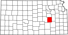
Location of Chase County in Kansas
This is a list of the National Register of Historic Places listings in Chase County, Kansas.
This is intended to be a complete list of the properties and districts on the National Register of Historic Places in Chase County, Kansas, United States. The locations of National Register properties and districts for which the latitude and longitude coordinates are included below, may be seen in a map.[1]
There are 17 properties and districts listed on the National Register in the county.
- This National Park Service list is complete through NPS recent listings posted December 16, 2016.[2]
Current listings
| [3] | Name on the Register[4] | Image | Date listed[5] | Location | City or town | Description |
|---|---|---|---|---|---|---|
| 1 | Cartter Building | 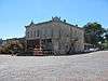 |
(#77000573) |
303 Broadway 38°22′19″N 96°32′30″W / 38.371944°N 96.541667°W |
Cottonwood Falls | |
| 2 | Cedar Point Mill | 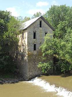 |
(#06001166) |
Junction of Main and 1st Sts. 38°15′42″N 96°49′10″W / 38.261667°N 96.819444°W |
Cedar Point | |
| 3 | Chase County Courthouse | Courthouse.JPG) |
(#71000304) |
On the square at the southern end of Broadway 38°22′21″N 96°32′30″W / 38.3725°N 96.541667°W |
Cottonwood Falls | |
| 4 | Chase County National Bank | 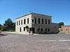 |
(#77000572) |
301 Broadway 38°22′19″N 96°32′30″W / 38.371944°N 96.541667°W |
Cottonwood Falls | |
| 5 | Clements Stone Arch Bridge | 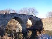 |
(#76000816) |
½ mile southeast of Clements over the Cottonwood River 38°17′42″N 96°44′05″W / 38.295°N 96.734722°W |
Clements | |
| 6 | Clover Cliff Ranch House | 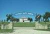 |
(#77000574) |
4 miles southwest of Elmdale off U.S. Route 50 38°19′55″N 96°41′47″W / 38.331944°N 96.696389°W |
Elmdale | |
| 7 | Cottonwood River Bridge | 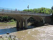 |
(#85001422) |
K-177, northern edge of Cottonwood Falls 38°22′30″N 96°32′26″W / 38.375°N 96.540556°W |
Cottonwood Falls | |
| 8 | Cottonwood River Pratt Truss Bridge | 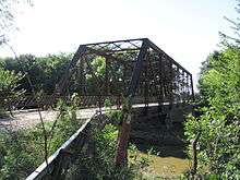 |
(#03000376) |
Main St., 0.8 miles west of intersection with 1st St. 38°15′36″N 96°50′02″W / 38.26°N 96.833889°W |
Cedar Point | |
| 9 | Crocker Ranch | 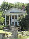 |
(#77000575) |
1.5 miles north of Matfield Green on K-177 38°10′55″N 96°34′05″W / 38.181944°N 96.568056°W |
Matfield Green | |
| 10 | Fox Creek Stone Arch Bridge |  |
(#06001164) |
½ mile north and ¾ mile west of junction of U.S. Route 50 and Cottonwood St. 38°24′08″N 96°32′54″W / 38.402222°N 96.548333°W |
Strong City | |
| 11 | Lower Fox Creek School | 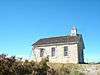 |
(#74000822) |
Northwest of Strong City on K-177 38°26′43″N 96°33′30″W / 38.445278°N 96.558333°W |
Strong City | |
| 12 | McNee Barns | Upload image | (#13000431) |
3 miles southwest of Elmdale on U.S. Highway 50 (SS T20S R7E) 38°20′15″N 96°40′47″W / 38.33760°N 96.6798°W |
Elmdale | |
| 13 | Pioneer Bluffs Ranch Historic District | Upload image | (#90001441) |
K-177 1 mile north of Matfield Green 38°10′33″N 96°33′50″W / 38.175833°N 96.563889°W |
Matfield Green | |
| 14 | William C. & Jane Shaft House | Upload image | (#10000449) |
1682 FP Rd. 38°18′53″N 96°43′58″W / 38.314722°N 96.732778°W |
Clements | |
| 15 | Spring Hill Farm and Stock Ranch House | 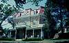 |
(#71000305) |
3 miles north of Strong City on K-177 38°26′03″N 96°33′27″W / 38.434167°N 96.5575°W |
Strong City | |
| 16 | Strong City Atchison, Topeka, & Santa Fe Depot | 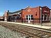 |
(#07000607) |
102 W. Topeka Ave. 38°23′42″N 96°32′24″W / 38.395°N 96.54°W |
Strong City | Built in 1913 for a cost of $20,000, the Atchison, Topeka, and Santa Fe Railroad Depot operated as a depot until 1938. It included two passenger waiting rooms, a ticket office, telegraph desk, main office, and baggage room, with the west end of the depot used as a freight office. |
| 17 | Whitney Ranch Historic District | Upload image | (#95000589) |
Southeast of Hymer off unnamed road 38°28′46″N 96°40′45″W / 38.479444°N 96.679167°W |
Hymer | |
| 18 | Wood House | .JPG) |
(#74000821) |
East of Cottonwood Falls 38°22′14″N 96°31′10″W / 38.370556°N 96.519444°W |
Cottonwood Falls |
See also
| Wikimedia Commons has media related to National Register of Historic Places in Chase County, Kansas. |
- List of National Historic Landmarks in Kansas
- National Register of Historic Places listings in Kansas
References
- ↑ The latitude and longitude information provided in this table was derived originally from the National Register Information System, which has been found to be fairly accurate for about 99% of listings. For about 1% of NRIS original coordinates, experience has shown that one or both coordinates are typos or otherwise extremely far off; some corrections may have been made. A more subtle problem causes many locations to be off by up to 150 yards, depending on location in the country: most NRIS coordinates were derived from tracing out latitude and longitudes off of USGS topographical quadrant maps created under the North American Datum of 1927, which differs from the current, highly accurate WGS84 GPS system used by most on-line maps. Chicago is about right, but NRIS longitudes in Washington are higher by about 4.5 seconds, and are lower by about 2.0 seconds in Maine. Latitudes differ by about 1.0 second in Florida. Some locations in this table may have been corrected to current GPS standards.
- ↑ "National Register of Historic Places: Weekly List Actions". National Park Service, United States Department of the Interior. Retrieved on December 16, 2016.
- ↑ Numbers represent an ordering by significant words. Various colorings, defined here, differentiate National Historic Landmarks and historic districts from other NRHP buildings, structures, sites or objects.
- ↑ National Park Service (2009-03-13). "National Register Information System". National Register of Historic Places. National Park Service.
- ↑ The eight-digit number below each date is the number assigned to each location in the National Register Information System database, which can be viewed by clicking the number.

Municipalities and communities of Chase County, Kansas, United States | ||
|---|---|---|
| Cities | | |
| Unincorporated communities | ||
| Ghost towns | ||
| Townships | ||
| Footnotes | ‡This populated place also has portions in an adjacent county or counties | |
This article is issued from Wikipedia - version of the 6/4/2016. The text is available under the Creative Commons Attribution/Share Alike but additional terms may apply for the media files.