Minami-ku, Sagamihara
| Minami 南区 | |
|---|---|
| Ward | |
| Minami Ward | |
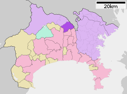 Map of Minami-ku, Sagamihara | |
 Minami
| |
| Coordinates: 35°31′50″N 139°25′45″E / 35.53056°N 139.42917°ECoordinates: 35°31′50″N 139°25′45″E / 35.53056°N 139.42917°E | |
| Country | Japan |
| Region | Kantō |
| Prefecture | Kanagawa |
| City | Sagamihara |
| Area | |
| • Total | 38.2 km2 (14.7 sq mi) |
| Population (February 1, 2010) | |
| • Total | 272,794 |
| • Density | 7,141/km2 (18,500/sq mi) |
| Time zone | Japan Standard Time (UTC+9) |
| Phone number | 042-749-2134 |
| Address | 31-1, Sagamiōno 5-chōme, Minami-Ku, Sagamihara-shi Kanagawa-ken 252-0377 |
| Website | Minami-ku home page |
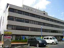
Sagamihara Minami-ku Ward Office
Minami-ku (南区 Minami-ku) is one of three wards of Sagamihara, Kanagawa, Japan, located in the east part of the city. The west of Minami-ku faces Chūō-ku.
Minami-ku was created on April 1, 2010 when Sagamihara became a city designated by government ordinance (a "designated city").
As of March 2010, Minami-ku had a population of 272,794, with a land area of 38.2 square kilometers.
| Wikimedia Commons has media related to Minami-ku, Sagamihara. |
| Wards of Yokohama | ||
|---|---|---|
| Wards of Kawasaki | ||
| Wards of Sagamihara | ||
| Core city | ||
| Special cities | ||
| Cities | ||
| Aikō District | ||
| Ashigarakami District | ||
| Ashigarashimo District | ||
| Kōza District | ||
| Miura District | ||
| Naka District | ||
This article is issued from Wikipedia - version of the 5/30/2015. The text is available under the Creative Commons Attribution/Share Alike but additional terms may apply for the media files.