Miura District, Kanagawa
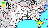
Miura District (三浦郡 Miura-gun) is a district located in Kanagawa Prefecture, Japan.
As of 2009, the district has an estimated population of 32,333 and a density of 1,900 persons per km². The total area is 17.06 km².
It currently consists of only one town, Hayama. The cities of Yokosuka, Zushi and Miura were formerly part of Miura District.
Towns and villages
History
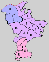
Miura District was one of the ancient subdivisions of Sagami Province, covering all of Miura Peninsula. It was under the control of the Miura clan from the late Heian period through the Sengoku period, and was held as tenryo territory administered by the Shogun under the Tokugawa Shogunate of the Edo period. After the Meiji Restoration, it was established as a district under the cadastral reform of 1878, with a district office built near what is now Shioiri Station.
Timeline
- On April 1, 1889 Miura District was divided into the following municipalities under the Meiji :
- three towns (Yokosuka, Uraga and Misaki)
- 12 villages (Toyoshima, Kinugasa, Urago, Kurihama, Nagai, Takeyama, Kitashitaura, Nakanishiura, Tagoe, Hayama, Minamishitaura and Hasse).
- On October 1, 1903, Toyoshima Village was promoted town status, but was absorbed into the town of Yokosuka on December 15, 1906 (which Yokosuka was promoted city status on February 15, 1907).
- On July 1, 1911, Nakanishiura Village was renamed as the village of Nishiura.
- On June 1, 1914, Urago Village was promoted town status and was renamed as the town of Taura.
- On April 1, 1924, Tagoe Village was promoted town status and was renamed as the town of Zushi.
- On January 1, 1925, Hayama Village was promoted town status.
- On February 2, 1925, Nagai Village was promoted town status.
- On February 15, 1933, Kinugasa Village was absorbed into the city of Yokosuka.
- On April 1, 1933, Taura Town was absorbed into the city of Yokosuka.
- On July 1, 1935, Nishiura Village was promoted town status and was renamed as the town of Okusu.
- On April 1, 1937, Kuriham Village was absorbed into the city of Yokosuka.
- On April 1, 1940, Minamishtaura Village was promoted town status.
- However, in 1943, Yokosuka expanded greatly by absorbing the towns of Uraga, Zushi, Nagai and Okusu and the two neighboring villages of Takeyama and Kitashitaura.
- On July 1, 1950, Zushi was separated from Yokosuka (becoming an independent municipality once again; which was promoted city status on July 1, 1954).
- On January 1, 1955, Minamishitaura Town, Misaki Town and Hasse Village merged to form the city of Miura.
As of 2009, this leaves only the town of Hayama as the sole remaining portion of Miura District.
Merger table
| before 1889 | April 1, 1889 | 1889 - 1926 | 1926 - 1944 | 1945 - 1954 | 1955 - 1989 | 1989 - present | present | |||
|---|---|---|---|---|---|---|---|---|---|---|
| Yokosuka Town | February 15, 1907 Yokosuka City |
Yokosuka City | Yokosuka City | Yokosuka City | Yokosuka City | Yokosuka City | ||||
| Toyoshima Village | October 1, 1903 Toyoshima Town |
December 15, 1906 merged with Yokosuka town | ||||||||
| Kinugasa Village | Kinugasa Village | February 15, 1933 merged with Yokosuka City | ||||||||
| Urago Village | June 1, 1914 Taura Town |
April 1, 1933 merged with Yokosuka City | ||||||||
| Kurihama Village | Kurihama Village | April 1, 1937 merged with Yokosuka City | ||||||||
| Uraga Town | Uraga Town | April 1, 1943 merged with Yokosuka City | ||||||||
| Nagai Village | February 2, 1925 Nagai Town | |||||||||
| Takeyama Village | Takeyama Village | |||||||||
| Kitashitaura Village | Kitashitaura Village | |||||||||
| Nakanishiura Village | July 1, 1911 Nishiura Village |
July 1, 1935 Okusu Village |
April 1, 1943 merged with Yokosuka City | |||||||
| Tagoe Village | April 1, 1924 Zushi Town |
April 1, 1943 merged with Yokosuka City |
July 1, 1950 Zushi Town |
April 1, 1954 Zushi City |
Zushi City | Zushi City | Zushi City | |||
| Hayama Village | January 1, 1925 Hayama Town |
Hayama Town | Hayama Town | Hayama Town | Hayama Town | Hayama Town | ||||
| Misaki Town | Misaki Town | Misaki Town | Misaki Town | January 1, 1955 Miura City |
Miura City | Miura City | ||||
| Minamishitaura Village | Minamishitaura Village | April 1, 1940 Minamishitaura Town |
Minamishitaura Town | |||||||
| Hasse Village | Hasse Village | Hasse Village | Hasse Village | |||||||
| Wards of Yokohama | ||
|---|---|---|
| Wards of Kawasaki | ||
| Wards of Sagamihara | ||
| Core city | ||
| Special cities | ||
| Cities | ||
| Aikō District | ||
| Ashigarakami District | ||
| Ashigarashimo District | ||
| Kōza District | ||
| Miura District | ||
| Naka District | ||
Coordinates: 35°16′02″N 139°36′14″E / 35.26722°N 139.60389°E