Miquon, Pennsylvania
| Miquon, Pennsylvania | |
|---|---|
| Unincorporated community | |
|
Battle of Barren Hill, 20 May 1778. Miquon includes Barren Hill and the area south of it. | |
 Miquon, Pennsylvania Location within the state of Pennsylvania | |
| Coordinates: 40°04′2.75″N 75°16′8.33″W / 40.0674306°N 75.2689806°WCoordinates: 40°04′2.75″N 75°16′8.33″W / 40.0674306°N 75.2689806°W | |
| Country |
|
| State |
|
| County |
|
| Township |
Whitemarsh Springfield |
| Time zone | EST (UTC-5) |
| • Summer (DST) | EDT (UTC-4) |
| ZIP codes |
19444 19428 |
| Area code(s) | 610 |

Miquon is a small unincorporated community in Whitemarsh Township and Springfield Township, Montgomery County, Pennsylvania.
The name comes from the Lenni-Lenape people, who were the original inhabitants. Located between the Roxborough section of Philadelphia and the Whitemarsh Township community of Spring Mill, Miquon is approximately bounded by Barren Hill Road, Ridge Pike, Manor Road, and the Schuylkill River.[1]
During the Revolutionary War, the May 20, 1778 Battle of Barren Hill began just east of the area. The Marquis de Lafayette and 2,200 Continental troops escaped capture by some 16,000 British troops by retreating through Miquon, fording the river, and returning to Valley Forge.
In the 19th century, the area became an industrial center for papermaking. The W. C. Hamilton Paper Company operated its mills until the mid-20th century. In 1999, the former mill buildings were redeveloped into an office complex named River Park I and II.[2][3] In 2012, River Park II became the campus of AIM Academy, a private secondary school.
The Reading Railroad's main line paralleled the Schuylkill River. About 1880, it opened the "Lafayette" passenger station at Manor Road. The original station building survives, and is attributed to architect Frank Furness.[4] The current station is southeast of this, and was built about 1910. Its name was changed from "Lafayette" to "Miquon" in 1921.[5] The Manayunk/Norristown Line now runs on the old Reading tracks.
The section along the river and the section west of Harts Lane share the 19428 zip code with Conshohocken. The section east of Harts Lane shares the 19444 zip code with Lafayette Hill.
Landmarks
- The Miquon School
- Miquon Station
- ACE Conference Center and Golf Club,[6][7] The largest landowner, with a total of more than 300 acres (1.214 km2).
Notable residents
- Derek Bok, former president of Harvard University
- Margaret Plummer Bok, co-founder of The Miquon School (1932)[8]
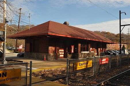 Minquon Station
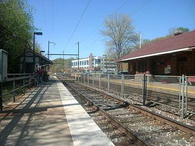 Miquon Station, 2012. River Park I is in the background.
Notes
- ↑ History of Miquon from The Miquon School.
- ↑ "River Park I". The Buccini/Pollin Group. Retrieved 20 August 2013.
- ↑ "River Park II". The Buccini/Pollin Group. Retrieved 20 August 2013.
- ↑ "National Historic Landmarks & National Register of Historic Places in Pennsylvania" (Searchable database). CRGIS: Cultural Resources Geographic Information System. Note: This includes Emily T. Cooperman (n.d.). "National Register of Historic Places Inventory Nomination Form: Upper Roxborough Historic District" (PDF). Retrieved 2013-08-20.
- ↑ History from Whitemarsh Township, Pennsylvania.
- ↑ ACE Conference Center
- ↑ ACE Golf Club
- ↑ Sissela Bok, Alva Myrdal: A Daughter's Memoir (Basic Books, 1991), p. 131.
