Jenkintown, Pennsylvania
| Borough of Jenkintown | |
| Borough | |
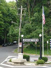 View entering Jenkintown from Wyncote, Cheltenham Township | |
| Country | United States |
|---|---|
| State | Pennsylvania |
| County | Montgomery |
| Elevation | 322 ft (98.1 m) |
| Coordinates | 40°05′46″N 75°07′46″W / 40.09611°N 75.12944°WCoordinates: 40°05′46″N 75°07′46″W / 40.09611°N 75.12944°W |
| Area | 0.6 sq mi (1.6 km2) |
| - land | 0.6 sq mi (2 km2) |
| - water | 0.0 sq mi (0 km2), 0% |
| Population | 4,422 (2010) |
| Density | 7,844.0/sq mi (3,028.6/km2) |
| Incorporated | December 8, 1874 |
| Government | Council-manager |
| Mayor | Ed Foley |
| Timezone | EST (UTC-5) |
| - summer (DST) | EDT (UTC-4) |
| ZIP Code | 19046 |
| Area code | 215 and 267 |
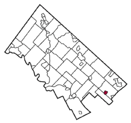 Location of Jenkintown in Montgomery County | |
 Location of Jenkintown in Pennsylvania | |
 Location of Pennsylvania in the United States | |
| Website: Borough website | |
Jenkintown is a borough in Montgomery County, Pennsylvania, about 10 miles (16 km) north of downtown Philadelphia. "Jenkintown" is also used to describe a number of neighborhoods surrounding the borough, which also are known by names such as Rydal, Jenkintown Manor and Noble. While the post office will deliver "Jenkintown"-addressed mail to these areas, they are not part of the political entity of Jenkintown; they are within Abington Township.
The Jenkintown-Wyncote train station is one of SEPTA's major stops; the Warminster Line, West Trenton Line, Airport Line, and Lansdale/Doylestown Line regional rail services all stop there.
The television series The Goldbergs is set in Jenkintown, Pennsylvania.
History
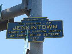
The community was named for Stephen Jenkins, a pioneer settler.[1]
The Borough of Jenkintown is located just outside Philadelphia along the Route 611 corridor between Abington and Cheltenham Townships. The Borough was settled in about 1697 and incorporated on December 8, 1874 when approximately 248 acres (1.00 km2) was taken from Abington Township. Today, the Borough is approximately 0.58 square miles and is home to 4,500 residents.
The Borough is a mostly residential community that is separated into East and West by the Business District that runs along and surrounds Old York Road (Route 611) corridor. On the east side of Old York Road, residential development is predominantly characterized by larger detached single-family homes on lots larger than the Borough average. On the southeast side of York Road, there is a small mixed concentration of row homes, duplexes, and single-family residences. The majority of the residential development, however, is located to the west of York Road. This area consists of a traditional small town mix of detached single-family homes, duplexes, and row homes. Located throughout this area are several multi-family apartment buildings that are residential rental properties. At the center of this residential area are the Jenkintown Elementary School and the Jenkintown High School.
The Jenkintown Fire Department consists of two fire companies founded more than 125 years ago. The Jenkintown Fire Department is a totally volunteer department consisting of the Pioneer Fire Company #1 and the Independent Fire Company #2. The Pioneer Company was organized in 1884 and the Independent Company was organized in 1889, an artifact of the historical split between Catholics and Protestants in the population of the borough. The two fire companies have a total membership of approximately 150 with 50 members comprising the active firefighting crew.
The Jenkins' Town Lyceum Building and Strawbridge and Clothier Store are listed on the National Register of Historic Places.[2]
Education
Public schools
Jenkintown has its own school district with grades from kindergarten to 12th. The mascot of Jenkintown High School is the Drake. The sports teams are known as the Drakes, or the Lady Drakes in the case of all-female teams.
Private schools
Unless noted, these institutions are located in Abington Township, but have a Jenkintown zip code:
- Saint Basil Academy (all-girls')
- Abington Friends School
- Manor College
For K-8th grade Catholic education, Jenkintown students attend Saint Joseph the Protector School in Glenside.
Geography
Jenkintown borough is located at 40°5′46″N 75°7′46″W / 40.09611°N 75.12944°W (40.096060, -75.129415).[3] According to the United States Census Bureau, the borough has a total area of 0.6 square miles (1.6 km2), all land. Pennsylvania Route 611 passes through the center of the borough.
Demographics
| Historical population | |||
|---|---|---|---|
| Census | Pop. | %± | |
| 1880 | 810 | — | |
| 1890 | 1,609 | 98.6% | |
| 1900 | 2,091 | 30.0% | |
| 1910 | 2,968 | 41.9% | |
| 1920 | 3,366 | 13.4% | |
| 1930 | 4,797 | 42.5% | |
| 1940 | 5,024 | 4.7% | |
| 1950 | 5,130 | 2.1% | |
| 1960 | 5,017 | −2.2% | |
| 1970 | 5,404 | 7.7% | |
| 1980 | 4,942 | −8.5% | |
| 1990 | 4,574 | −7.4% | |
| 2000 | 4,478 | −2.1% | |
| 2010 | 4,422 | −1.3% | |
| Est. 2015 | 4,431 | [4] | 0.2% |
| Sources:[5][6][7] | |||
As of the 2010 census, the borough was 87.5% White, 5.7% Black or African American, 2.0% Asian, and 1.8% were two or more races. 3.0% of the population were of Hispanic or Latino ancestry .
As of the census[6] of 2000, there were 4,478 people, 2,035 households, and 1,088 families residing in the borough. The population density was 7,844.0 people per square mile (3,033.3/km2). There were 2,085 housing units at an average density of 3,652.2 per square mile (1,412.3/km2). The racial makeup of the borough was 93.61% White, 4.00% African American, 0.04% Native American, 0.94% Asian, 0.02% Pacific Islander, 0.49% from other races, and 0.89% from two or more races. Hispanic or Latino of any race were 1.30% of the population.
There were 2,035 households, out of which 24.3% had children under the age of 18 living with them, 42.2% were married couples living together, 8.6% had a female householder with no husband present, and 46.5% were non-families. 40.6% of all households were made up of individuals, and 19.3% had someone living alone who was 65 years of age or older. The average household size was 2.19 and the average family size was 3.08.
In the borough the population is spread out, with 22.9% under the age of 18, 5.6% from 18 to 24, 27.0% from 25 to 44, 23.5% from 45 to 64, and 21.0% who were 65 years of age or older. The median age was 42 years. For every 100 females there were 78.9 males. For every 100 females age 18 and over, there were 73.2 males.
The median income for a household in the borough was $47,743, and the median income for a family was $72,902. Males had a median income of $41,970 versus $35,625 for females. The per capita income for the borough was $29,834. About 1.9% of families and 5.1% of the population were below the poverty line, including 3.6% of those under age 18 and 7.2% of those age 65 or over.
Politics and government
| Year | Republican | Democratic |
|---|---|---|
| 2012 | 27.1% 724 | 71.4% 1,905 |
| 2008 | 25.1% 708 | 73.8% 2,079 |
| 2004 | 28.6% 832 | 71.0% 2,068 |
| 2000 | 29.9% 791 | 65.7% 1,734 |
Jenkintown has a city manager form of government with a mayor and a twelve-member borough council. The current mayor is Ed Foley. Deborra Sines Pancoe is the President of Borough Council, and Richard Bunker is Vice President.
The borough is part of the Thirteenth Congressional District (represented by Rep. Brendan Boyle), Pennsylvania's 154th Representative District (represented by Rep. Steve McCarter) and Pennsylvania's 4th Senatorial District (represented by Sen. Arthur L. Haywood III). Jenkintown, like its surroundings of Abington Township, Pennsylvania and Cheltenham Township, Pennsylvania and their included towns, votes overwhelmingly Democratic. Jenkintown is a very liberal suburb of Philadelphia, Pennsylvania, as Jenkintown, along with its surroundings, have voted Democratic very often, both in local and national elections.
Notable people
- Jim Bidlack, professor at University of Central Oklahoma and co-founder of The Genome Registry
- Adam F. Goldberg, producer of The Goldbergs (TV series). The series is also set in Jenkintown.
- Ezra Pound, American poet and critic who was a major figure of the early modernist movement.
- George Low, Sr., Scottish golf professional (operated a driving range in Jenkintown circa 1936)
- George Low, Jr., American golf professional (operated a driving range in Jenkintown with his father George circa 1936)
- Lessing J. Rosenwald, former president and chairman of Sears, Roebuck and Company
- Max Ritter, founding member and former president of the World Swimming Associaton FINA
- Allyson Schwartz, American politician
- Bradley Cooper, Academy Award and Tony-nominated film and theatre actor, grew up in Jenkintown.
- Daniel Gans, Constable of Jenkintown's 4th Ward.
- Evelyn J Furse, federal magistrate judge for the United States District Court for the District of Utah

References
- ↑ "Historic Jenkintown". Jenkintown Community Alliance. Retrieved April 27, 2009.
- ↑ National Park Service (2010-07-09). "National Register Information System". National Register of Historic Places. National Park Service.
- ↑ "US Gazetteer files: 2010, 2000, and 1990". United States Census Bureau. 2011-02-12. Retrieved 2011-04-23.
- ↑ "Annual Estimates of the Resident Population for Incorporated Places: April 1, 2010 to July 1, 2015". Retrieved July 2, 2016.
- ↑ "Census of Population and Housing". U.S. Census Bureau. Retrieved 11 December 2013.
- 1 2 "American FactFinder". United States Census Bureau. Retrieved 2008-01-31.
- ↑ "Incorporated Places and Minor Civil Divisions Datasets: Subcounty Resident Population Estimates: April 1, 2010 to July 1, 2012". Population Estimates. U.S. Census Bureau. Retrieved 11 December 2013.
External links
| Wikimedia Commons has media related to Jenkintown, Pennsylvania. |
Municipalities and communities of Montgomery County, Pennsylvania, United States | ||
|---|---|---|
| Boroughs |  | |
| Townships |
| |
| CDPs |
| |
| Unincorporated communities |
| |
| Footnotes | ‡This populated place also has portions in an adjacent county or counties | |