Pottstown, Pennsylvania
| Borough of Pottstown | |
| Borough | |
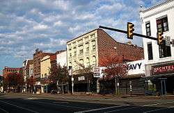 High Street, east of North Hanover Street, looking north. | |
| Country | United States |
|---|---|
| State | Pennsylvania |
| County | Montgomery |
| Elevation | 203 ft (61.9 m) |
| Coordinates | 40°14′59″N 75°38′25″W / 40.24972°N 75.64028°WCoordinates: 40°14′59″N 75°38′25″W / 40.24972°N 75.64028°W |
| Area | 4.9 sq mi (12.7 km2) |
| - land | 4.8 sq mi (12 km2) |
| - water | 0.1 sq mi (0 km2), 2.04% |
| Population | 22,377 (2010) |
| Density | 4,526.3/sq mi (1,747.6/km2) |
| Founded | 1752 |
| - Incorporated | February 6, 1815 |
| Government | Council-manager |
| Mayor | Sharon Valentine-Thomas |
| Timezone | EST (UTC-5) |
| - summer (DST) | EDT (UTC-4) |
| ZIP Codes | 19464 |
| Area code | 610 and 484 |
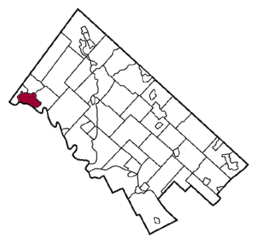 Location of Pottstown in Montgomery County
| |
 Location of Pottstown in Pennsylvania
| |
 Location of Pennsylvania in the United States
| |
| Website: http://www.pottstown.org | |
Pottstown is a borough in Montgomery County, Pennsylvania, United States about 40 miles (55 km) northwest of Philadelphia and 20 miles (32 km) southeast of Reading, on the Schuylkill River. Pottstown was laid out in 1752–53 and named Pottsgrove in honor of its founder, John Potts. The old name was abandoned at the time of the incorporation as a borough in 1815. In 1888, the limits of the borough were considerably extended. Pottstown is the center of a productive farming and dairying region.
In the past, its iron and steel interests were very extensive. There were large rolling mills, furnaces, nail works, textile mills, bridge works, agricultural-implement works, boiler and machine shops, foundries, and manufactories of bricks, silks, shirts, hosiery, etc. In 1900, 13,696 people lived there; in 1910, 15,599; in 1920, 17,431; and in 1940, 20,194 people lived there. The population was 22,377 at the 2010 census.
Pottstown is not to be confused with Pottsville, a city in Schuylkill County well known for being the home of the Yuengling brewery.
History
Modern-day Pottstown is established on land originally deeded to William Penn.[1] Germans, Swedes and English were among the first European settlers in the area. After establishment of the first iron forge in 1714, Pottstown's fortunes became tied to the iron industry.
Eventually, blast furnaces for production of iron and later steel opened in the area. Iron and steel production brought the Potts family, iron masters by trade, to the area. They established a forge in the area and built a large home just west of the Manatawny Creek. John Potts founded a town in 1761 on part of the 995 acres (4.03 km2) that he owned. It is the home of the nations oldest mills, Pottstown Roller Mill.
Over time, Pottsgrove grew and in 1815, was incorporated under the name Pottstown becoming the second borough in Pennsylvania after Norristown.
The Philadelphia & Reading Railroad mainline between Reading and Philadelphia reached Pottstown in 1838. The extension of the railroad to Mount Carbon in 1842 facilitated the movement of raw materials and finished goods which helped Pottstown's economy to grow. In the few years following the extension of the railroad, the population grew from 600 to 1,850 residents. Pottstown's metal production grew and notably, steel from the borough was used in the Panama Canal and Golden Gate Bridge.[2]
In 1944, the borough adopted a city manager form of government. By 1964, the borough saw the need to re-organize the municipal government. At the time, it had one of the largest borough councils in the state, with 20 members. This was reduced to seven members in redrawn wards.
The High Street Historic District, Old Pottstown Historic District, Pottsgrove Mansion, Grubb Mansion, Jefferson Elementary School, Pottstown Roller Mill, Reading Railroad Pottstown Station, and Henry Antes House are listed on the National Register of Historic Places.[3]
Politics and government
Pottstown has a city manager form of government with a mayor and a seven-member borough council. The mayor is Sharon Thomas and the manager is Mark Flanders.
The borough is part of the Sixth Congressional District (represented by Rep. Ryan Costello), the 146th State House District (represented by state Rep. Tom Quigley) and the 44th State Senate District (represented by Sen. John Rafferty, Jr.).
Geography
Pottstown is located at 40°14′59″N 75°38′25″W / 40.24972°N 75.64028°W (40.249690, -75.640262).[4]
According to the United States Census Bureau, the borough has a total area of 4.9 square miles (13 km2), of which 4.8 square miles (12 km2) is land and 0.1 square miles (0.2 km2 or 1.83%) is water.
Climate
The climate in this area is characterized by hot, humid summers and generally mild to cool winters. According to the Köppen Climate Classification system, Pottstown, Pennsylvania has a humid subtropical climate, abbreviated "Cfa" on climate maps.[5] The hardiness zone is 7a bordering on 6b.
| Climate data for Pottstown, Pennsylvania | |||||||||||||
|---|---|---|---|---|---|---|---|---|---|---|---|---|---|
| Month | Jan | Feb | Mar | Apr | May | Jun | Jul | Aug | Sep | Oct | Nov | Dec | Year |
| Average high °C (°F) | 3 (38) |
4 (39) |
10 (50) |
16 (61) |
23 (73) |
27 (81) |
30 (86) |
28 (83) |
25 (77) |
19 (66) |
11 (52) |
5 (41) |
17 (62) |
| Average low °C (°F) | −4 (25) |
−4 (24) |
0 (32) |
6 (42) |
11 (52) |
16 (61) |
19 (66) |
18 (64) |
14 (57) |
8 (46) |
3 (37) |
−3 (27) |
7 (44) |
| Average precipitation mm (inches) | 84 (3.3) |
81 (3.2) |
97 (3.8) |
84 (3.3) |
107 (4.2) |
97 (3.8) |
122 (4.8) |
100 (4) |
81 (3.2) |
80 (3) |
81 (3.2) |
84 (3.3) |
1,090 (43) |
| Source: Weatherbase [6] | |||||||||||||
Demographics
| Historical population | |||
|---|---|---|---|
| Census | Pop. | %± | |
| 1830 | 676 | — | |
| 1840 | 721 | 6.7% | |
| 1850 | 1,664 | 130.8% | |
| 1860 | 2,380 | 43.0% | |
| 1870 | 4,125 | 73.3% | |
| 1880 | 5,305 | 28.6% | |
| 1890 | 13,285 | 150.4% | |
| 1900 | 13,696 | 3.1% | |
| 1910 | 15,599 | 13.9% | |
| 1920 | 17,431 | 11.7% | |
| 1930 | 19,430 | 11.5% | |
| 1940 | 20,194 | 3.9% | |
| 1950 | 22,589 | 11.9% | |
| 1960 | 26,144 | 15.7% | |
| 1970 | 25,355 | −3.0% | |
| 1980 | 22,729 | −10.4% | |
| 1990 | 21,831 | −4.0% | |
| 2000 | 21,859 | 0.1% | |
| 2010 | 22,377 | 2.4% | |
| Est. 2015 | 22,664 | [7] | 1.3% |
| Sources:[8][9][10] | |||
| Year | Republican | Democratic |
|---|---|---|
| 2012 | 33.3% 2,825 | 65.1% 5,527 |
| 2008 | 29.2% 2,737 | 69.5% 6,506 |
| 2004 | 38.0% 3,069 | 61.3% 4,950 |
| 2000 | 40.0% 2,459 | 56.1% 3,448 |
As of the 2010 census, the borough was 72.1% White, 19.5% Black or African American, 0.3% Native American, 0.9% Asian, 0.1% Native Hawaiian, and 4.4% were two or more races. 8.0% of the population were of Hispanic or Latino ancestry .
As of 2006-2008 Census Bureau Estimates,[11] there were 22,018 people living in Pottstown. The racial makeup of the borough was 72.1% White, 19.4% African American, 0.2% Native American, 0.9% Asian, 0.0% Pacific Islander, 2.2% from other races, and 5.1% from two or more races. Hispanic or Latino of any race were 5.6% of the population.
As of the census[9] of 2000, there were 21,859 people, 9,146 households, and 5,533 families residing in the borough. The population density was 4,526.3 people per square mile (1,747.4/km2). There were 9,973 housing units at an average density of 2,065.1 per square mile (797.2/km2). The racial makeup of the borough was 79.34% White, 15.06% African American, 0.23% Native American, 0.65% Asian, 0.09% Pacific Islander, 1.89% from other races, and 2.75% from two or more races. Hispanic or Latino of any race were 4.53% of the population.
There were 9,146 households, out of which 29.1% had children under the age of 18 living with them, 41.3% were married couples living together, 14.7% had a female householder with no husband present, and 39.5% were non-families. 33.5% of all households were made up of individuals, and 13.4% had someone living alone who was 65 years of age or older. The average household size was 2.36 and the average family size was 3.02.
In the borough the population was spread out, with 25.6% under the age of 18, 7.5% from 18 to 24, 30.9% from 25 to 44, 19.8% from 45 to 64, and 16.2% who were 65 years of age or older. The median age was 36 years. For every 100 females there were 90.5 males. For every 100 females age 18 and over, there were 85.6 males.
The median income for a household in the borough was $35,785, and the median income for a family was $45,734. Males had a median income of $34,923 versus $26,229 for females. The per capita income for the borough was $19,078. About 8.7% of families and 11.3% of the population were below the poverty line, including 15.2% of those under age 18 and 8.8% of those age 65 or over.
Transportation
The main east-west street in Pottstown is High Street, which continues east of the borough as Ridge Pike. The main north-south street in the borough is Hanover Street. The U.S. Route 422 freeway passes to the south of Pottstown and heads east to King of Prussia and Philadelphia and west to Reading. Pennsylvania Route 100 runs north-south through the Pottstown area, heading south to West Chester and north to Allentown. Pennsylvania Route 663 begins at PA 100 in Pottstown and follows King Street east and Charlotte Street northeast before leaving the borough and continuing to Pennsburg and Quakertown. Pennsylvania Route 724 runs along the south bank of the Schuylkill River in Chester County.[12]
Bus service in Pottstown and the surrounding communities is a publicly owned and privately operated system. The Borough of Pottstown owns, funds, and administers the system. The day-to-day operations are the responsibility of Pottstown Area Rapid Transit, Inc. SEPTA's Route 93 bus connects Pottstown with the Norristown Transportation Center in Norristown.
Pottstown is serviced by Pottstown Municipal Airport, a general aviation airport, and a short distance from Pottstown is Pottstown Limerick Airport located in Limerick.
Passenger train service between Reading/Pottstown and Philadelphia was operated by Conrail under the auspices of SEPTA until July 29, 1981, when all diesel services were terminated. Efforts to reinstitute commuter trains, such as the Schuylkill Valley Metro, have been unsuccessful. The station still exists and is currently home to a district justice office. The Colebrookdale Railroad is a tourist line running from Pottstown to Boyertown.
Education
Public library
- Pottstown Regional Public Library (website: http://ppl.mclinc.org/ )
Colleges
- Montgomery County Community College – West Campus
Public School Districts
- The Pottstown School District serves the borough.
- The Pottsgrove School District serves the surrounding townships in Montgomery County.
- The Owen J. Roberts School District serves the rural area to the south of the borough in Chester County, such as Warwick Township, East Nantmeal Township, South Coventry Township, North Coventry Township, East Vincent Township, East Coventry Township and West Vincent Township.
Private Schools
- The Hill School
- Wyndcroft School
- Saint Aloysius School
- Stowe Lighthouse Christian Academy
Media
Newspapers
Pottstown Mercury
The Mercury has the unique distinction of being the smallest circulation newspaper in the U.S. to have its staffers win two Pulitzer Prizes. The first award came in 1979 in the Spot News Photography category by staff photographer Tom Kelly. The second Pulitzer Prize came in 1990 for Editorial Writing by Tom Hylton.
Television
PCTV
PCTV (Pottstown Community TV) is owned and operated by the Borough of Pottstown and provides local Government-access television (GATV) programming over Comcast Cable TV in over 77,000 homes in western Montgomery County, Northern Chester County and Eastern Berks County. In existence since 1983, PCTV currently produces programming on three local Cable Channels 22, 27 and 98).[13]
PCTV also covers local high school sports such as football, basketball, swimming or baseball.
Radio
WPAZ operates at 1370AM and serves the Greater Philadelphia Area. Originally WPAZ, the station changed its call letters to WBZH on October 28, 2011 and back to WPAZ on January 25, 2013. On November 1, 2013 the station began a traditional Christian music format of religious hymns and songs
Notable people
- Jacob Albright, a founder of United Methodist Church, was born in Pottstown in 1759[14]
- Aaron Beasley, former NFL cornerback for the Jacksonville Jaguars, New York Jets, and Atlanta Falcons
- John R. Brooke, military officer (who rose to Major General) during the American Civil War and Spanish–American War
- Dante Calabria, former professional Italian League basketball player; played at University of North Carolina under coach Dean Smith
- Naomi Childers, silent-film actress
- Al Grey, jazz trombonist, known for plunger technique, featured with Count Basie as soloist
- Daryl Hall, member of the Grammy Award winning American rock group Hall & Oates
- Dick Harter, former college and NBA basketball coach
- Geof Manthorne, cake artist, co-star of Food Network's reality TV series Ace Of Cakes
- Cole "CPTime" Parkinson, rapper and recording artist
- George Seasholtz, former NFL fullback
- Bobby Shantz, former MLB pitcher
- Don Strock, retired NFL quarterback
- Earl Strom, former NBA referee
- Buck Weaver, former MLB shortstop for Chicago White Sox, involved in 1919 Black Sox Scandal
- Rian Wallace, former NFL linebacker
- Lionel Douglass, Former Actor and stand in double for "Danny Glover" ;Traveled with Sesame Street Live as "Big Bird"
References
- ↑ "Pottsgrove Manor History". MontcoPA.org. Retrieved 22 Nov 2014.
- ↑ Pottstown History from Official City Website
- ↑ National Park Service (2010-07-09). "National Register Information System". National Register of Historic Places. National Park Service.
- ↑ "US Gazetteer files: 2010, 2000, and 1990". United States Census Bureau. 2011-02-12. Retrieved 2011-04-23.
- ↑ Climate Summary for Pottstown, Pennsylvania
- ↑ "Weatherbase.com". Weatherbase. 2013. Retrieved on October 24, 2013.
- ↑ "Annual Estimates of the Resident Population for Incorporated Places: April 1, 2010 to July 1, 2015". Retrieved July 2, 2016.
- ↑ "Census of Population and Housing". U.S. Census Bureau. Retrieved 11 December 2013.
- 1 2 "American FactFinder". United States Census Bureau. Retrieved 2008-01-31.
- ↑ "Incorporated Places and Minor Civil Divisions Datasets: Subcounty Resident Population Estimates: April 1, 2010 to July 1, 2012". Population Estimates. U.S. Census Bureau. Retrieved 11 December 2013.
- ↑ "2006-2008 American Community Survey 3-Year Estimates". Retrieved 2010-08-06.
- ↑ Google (November 21, 2013). "overview of Pottstown, Pennsylvania" (Map). Google Maps. Google. Retrieved November 21, 2013.
- ↑ http://www.pottscommtv.com/pctv1.htm
- ↑ Who Was Who in America, Historical Volume, 1607-1896. Marquis Who's Who. 1967.
External links
- Borough of Pottstown
- Chamber of Commerce
- Pottstown Public Library
- Pottstown Memorial Medical Center
- Pottstown community message board
- The Gallery School of Pottstown & Gallery on High
 |
|
| ||
| |
|
| ||
| ||||
| | ||||
| |
