| [4] |
Name on the Register[5] |
Image |
Date listed[6] |
Location |
City or town |
Description |
|---|
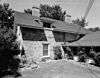
| 1 |
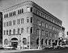
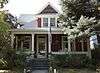
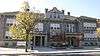
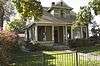
Walter Abbs House |
|
000000001982-11-17-0000November 17, 1982
(#82000175) |
915 Fort St.
43°37′21″N 116°11′54″W / 43.6225°N 116.198333°W / 43.6225; -116.198333 (Walter Abbs House) |
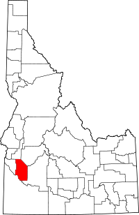
Boise |
|
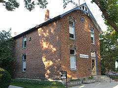
| 2 |
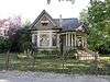
Ada Odd Fellows Temple |
|
000000001982-11-17-0000November 17, 1982
(#82000176) |
109-115½ N. 9th St.
43°36′58″N 116°12′15″W / 43.616111°N 116.204167°W / 43.616111; -116.204167 (Ada Odd Fellows Temple) |
Boise |
Only parts of the facade still standing
|
| 3 |
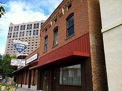
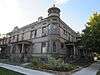
Ada Theater |
|
000000001974-11-21-0000November 21, 1974
(#74000724) |
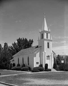
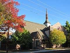
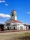
700 Main St.
43°36′54″N 116°12′05″W / 43.615°N 116.201389°W / 43.615; -116.201389 (Ada Theater) |
Boise |
|
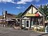
| 4 |
Aiken's Hotel |
Upload image |
000000001982-10-29-0000October 29, 1982
(#82000177) |
99 E. State St.
43°41′42″N 116°21′08″W / 43.695°N 116.352222°W / 43.695; -116.352222 (Aiken's Hotel) |
Eagle |
|
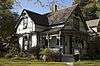
| 5 |
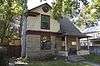
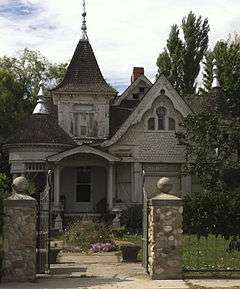
Alexander House |
|
000000001972-08-07-0000August 7, 1972
(#72000431) |
304 State St.
43°36′57″N 116°11′41″W / 43.615972°N 116.194722°W / 43.615972; -116.194722 (Alexander House) |
Boise |
|
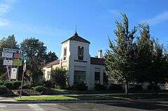
| 6 |
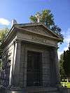
Alexanders |
|
000000001978-11-20-0000November 20, 1978
(#78001029) |
9th and Main Sts.
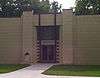
43°36′59″N 116°12′12″W / 43.616389°N 116.203333°W / 43.616389; -116.203333 (Alexanders) |
Boise |
|
| 7 |
Marion Allsup House |
|
000000001982-11-17-0000November 17, 1982
(#82000178) |
1601 N. 10th
43°37′43″N 116°11′57″W / 43.628611°N 116.199167°W / 43.628611; -116.199167 (Marion Allsup House) |
Boise |
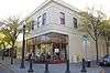
|
| 8 |
Anduiza Hotel |
|
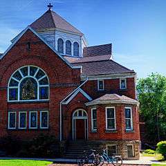
000000002003-02-25-0000February 25, 2003
(#03000064) |
619 Grove St.
43°36′51″N 116°12′06″W / 43.614167°N 116.201667°W / 43.614167; -116.201667 (Anduiza Hotel) |
Boise |
|
| 9 |
Artesian Water Co. Pumphouse and Wells |
|
000000001979-07-26-0000July 26, 1979
(#79000763) |
Off Warm Springs Avenue, formally State Highway 21
43°36′16″N 116°09′46″W / 43.604444°N 116.162778°W / 43.604444; -116.162778 (Artesian Water Co. Pumphouse and Wells) |
Boise |
|
| 10 |
Assay Office |
|
000000001966-10-15-0000October 15, 1966
(#66000305) |
210 Main St.
43°36′41″N 116°11′45″W / 43.611389°N 116.195833°W / 43.611389; -116.195833 (Assay Office) |
Boise |
|
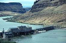
| 11 |
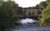
Barber Dam and Lumber Mill |
|
000000001978-11-21-0000November 21, 1978
(#78001037) |
East of Boise
43°33′44″N 116°07′16″W / 43.562222°N 116.121111°W / 43.562222; -116.121111 (Barber Dam and Lumber Mill) |
Boise |
|
| 12 |
Albert Beck House |
Upload image |
000000001982-11-17-0000November 17, 1982
(#82000179) |
1101 Fort St.
43°37′25″N 116°12′02″W / 43.623611°N 116.200556°W / 43.623611; -116.200556 (Albert Beck House) |
Boise |
|
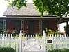
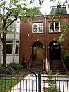
| 13 |
R. H. and Jessie Bell House |
Upload image |
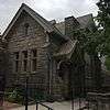
000000002006-02-01-0000February 1, 2006
(#05001599) |
137 E. Pine St.
43°36′42″N 116°23′22″W / 43.611667°N 116.389444°W / 43.611667; -116.389444 (R. H. and Jessie Bell House) |
Meridian |
|
| 14 |
Boise Capitol Area District |
|
000000001976-05-12-0000May 12, 1976
(#76000663) |
Roughly bounded by 6th and Bannock, N. 8th, 8th, State, 5th, and Jefferson Sts.
43°37′01″N 116°11′59″W / 43.616944°N 116.199722°W / 43.616944; -116.199722 (Boise Capitol Area District) |
Boise |
|
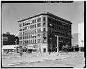
| 15 |
Boise City National Bank |
|
000000001978-11-28-0000November 28, 1978
(#78001030) |
8th and Idaho Sts.
43°36′59″N 116°12′08″W / 43.616389°N 116.202222°W / 43.616389; -116.202222 (Boise City National Bank) |
Boise |
|
| 16 |
Boise City-Silver City Road-Fick Property Segment |
Upload image |
000000001999-07-15-0000July 15, 1999
(#99000852) |
3232 W. Kuna-Mora Rd.
43°27′35″N 116°27′25″W / 43.459722°N 116.456944°W / 43.459722; -116.456944 (Boise City-Silver City Road-Fick Property Segment) |
Kuna |
|
| 17 |
Boise High School Campus |
|
000000001982-11-17-0000November 17, 1982
(#82000180) |
Washington St. between 9th and 11th Sts.
43°37′15″N 116°12′03″W / 43.620833°N 116.200833°W / 43.620833; -116.200833 (Boise High School Campus) |
Boise |
|
| 18 |
Boise Historic District |
|
000000001977-11-09-0000November 9, 1977
(#77000448) |
5th and 6th Sts., both sides of Idaho and Main Sts.
43°36′52″N 116°11′59″W / 43.614444°N 116.199722°W / 43.614444; -116.199722 (Boise Historic District) |
Boise |
|
| 19 |
Boise Junior College Administration Building |
|
000000001982-11-17-0000November 17, 1982
(#82000181) |
Boise State University campus
43°36′13″N 116°12′13″W / 43.603611°N 116.203611°W / 43.603611; -116.203611 (Boise Junior College Administration Building) |
Boise |
|
| 20 |
Boise Junior High School |
|
000000001982-11-17-0000November 17, 1982
(#82000186) |
1105 N. 13th St.
43°37′33″N 116°12′11″W / 43.625833°N 116.203056°W / 43.625833; -116.203056 (Boise Junior High School) |
Boise |
|
| 21 |
Boulevard Mo-tel |
|
000000001998-01-07-0000January 7, 1998
(#97001609) |
1121 S. Capitol Boulevard
43°36′25″N 116°12′36″W / 43.606944°N 116.21°W / 43.606944; -116.21 (Boulevard Mo-tel) |
Boise |
|
| 22 |
Joseph Bown House |
Upload image |
000000001979-06-18-0000June 18, 1979
(#79000768) |
2020 E. Victory Rd.
43°34′34″N 116°09′23″W / 43.576111°N 116.156389°W / 43.576111; -116.156389 (Joseph Bown House) |
Boise |
|
| 23 |
Brunzell House |
|
000000001982-11-17-0000November 17, 1982
(#82000182) |
916 Franklin St.
43°37′16″N 116°12′00″W / 43.621111°N 116.2°W / 43.621111; -116.2 (Brunzell House) |
Boise |
|
| 24 |
H. H. Bryant Garage |
|
000000001982-11-17-0000November 17, 1982
(#82000184) |
11th and Front Sts.
43°36′58″N 116°12′25″W / 43.616111°N 116.206944°W / 43.616111; -116.206944 (H. H. Bryant Garage) |
Boise |
Replaced by a new garage building (now a bar) in 1990.[7]
|
| 25 |
H. C. Burnett House |
|
000000001982-11-17-0000November 17, 1982
(#82000183) |
124 W. Bannock St.
43°36′49″N 116°11′38″W / 43.613611°N 116.193889°W / 43.613611; -116.193889 (H. C. Burnett House) |
Boise |
|
| 26 |
Bushnell-Fisher House |
Upload image |
000000002011-11-02-0000November 2, 2011
(#11000777) |
349 W. State St.
43°41′41″N 116°21′30″W / 43.694722°N 116.358333°W / 43.694722; -116.358333 (Bushnell-Fisher House) |
Eagle |
|
| 27 |
Capitol Boulevard Memorial Bridge |
|
000000001990-11-05-0000November 5, 1990
(#90001717) |
Capitol Boulevard over the Boise River
43°36′32″N 116°12′26″W / 43.608889°N 116.207222°W / 43.608889; -116.207222 (Capitol Boulevard Memorial Bridge) |
Boise |
|
| 28 |
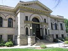
Carnegie Public Library |
|
000000001974-11-21-0000November 21, 1974
(#74000725) |
815 W. Washington St.
43°37′10″N 116°11′58″W / 43.619444°N 116.199444°W / 43.619444; -116.199444 (Carnegie Public Library) |
Boise |
|
| 29 |
C. C. Cavanah House |
Upload image |
000000001982-11-17-0000November 17, 1982
(#82000185) |
107 E. Idaho St.
43°36′43″N 116°11′36″W / 43.611944°N 116.193333°W / 43.611944; -116.193333 (C. C. Cavanah House) |
Boise |
|
| 30 |
Chinese Odd Fellows Building |
|
000000001982-11-17-0000November 17, 1982
(#82000187) |
610-612 Front St.
43°36′49″N 116°12′07″W / 43.613611°N 116.201944°W / 43.613611; -116.201944 (Chinese Odd Fellows Building) |
Boise |
|
| 31 |
Joseph Chitwood House |
Upload image |
000000002006-08-23-0000August 23, 2006
(#06000709) |
1321 Denver St.
43°35′48″N 116°11′39″W / 43.596667°N 116.194167°W / 43.596667; -116.194167 (Joseph Chitwood House) |
Boise |
|
| 32 |
Christ Chapel |
|
000000001974-07-17-0000July 17, 1974
(#74000726) |
Broadway at Campus Dr.
43°36′12″N 116°11′34″W / 43.603333°N 116.192778°W / 43.603333; -116.192778 (Christ Chapel) |
Boise |
|
| 33 |
Christian Church |
|
000000001978-02-17-0000February 17, 1978
(#78001031) |
9th and Franklin Sts.
43°37′15″N 116°11′59″W / 43.620833°N 116.199722°W / 43.620833; -116.199722 (Christian Church) |
Boise |
|
| 34 |
Henry Coffin House |
|
000000001982-11-17-0000November 17, 1982
(#82000188) |
1403 Franklin St.
43°37′26″N 116°12′20″W / 43.623889°N 116.205556°W / 43.623889; -116.205556 (Henry Coffin House) |
Boise |
|
| 35 |
Cole School and Gymnasium |
Upload image |
000000001982-11-08-0000November 8, 1982
(#82000189) |
7145 Fairview Ave.
43°37′08″N 116°16′27″W / 43.618889°N 116.274167°W / 43.618889; -116.274167 (Cole School and Gymnasium) |
Boise |
|
| 36 |
Collister School |
Upload image |
000000001982-11-08-0000November 8, 1982
(#82000190) |
4426 Catalpa Dr.
43°39′21″N 116°14′35″W / 43.655833°N 116.243056°W / 43.655833; -116.243056 (Collister School) |
Boise |
|
| 37 |
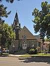
Congregation Beth Israel Synagogue |
|
000000001972-11-03-0000November 3, 1972
(#72000432) |
1102 State St.
43°37′15″N 116°12′15″W / 43.6208°N 116.20406°W / 43.6208; -116.20406 (Congregation Beth Israel Synagogue) |
Boise |
|
| 38 |
John Daly House |
|
000000001982-11-17-0000November 17, 1982
(#82000191) |
1015 W. Hays St.
43°37′19″N 116°11′57″W / 43.621944°N 116.199167°W / 43.621944; -116.199167 (John Daly House) |
Boise |
|
| 39 |
Dr. James Davies House |
|
000000001982-11-17-0000November 17, 1982
(#82000192) |
1107 W. Washington St.
43°37′17″N 116°12′11″W / 43.621389°N 116.203056°W / 43.621389; -116.203056 (Dr. James Davies House) |
Boise |
|
| 40 |
R. K. Davis House |
|
000000001982-11-17-0000November 17, 1982
(#82000193) |
1016 Franklin St.
43°37′19″N 116°12′03″W / 43.621944°N 116.200833°W / 43.621944; -116.200833 (R. K. Davis House) |
Boise |
|
| 41 |
Diversion Dam and Deer Flat Embankments |
|
000000001976-03-15-0000March 15, 1976
(#76000666) |
Southeast of Boise on the Boise River
43°32′16″N 116°05′36″W / 43.537810°N 116.093425°W / 43.537810; -116.093425 (Diversion Dam and Deer Flat Embankments) |
Boise |
Extends into Canyon County
|
| 42 |
Dry Creek Rockshelter |
|
000000001991-11-22-0000November 22, 1991
(#91001719) |
Address Restricted[8]
|
Boise |
|
| 43 |
William Dunbar House |
Upload image |
000000001982-11-17-0000November 17, 1982
(#82000195) |
1500 W. Hays St.
43°37′32″N 116°12′20″W / 43.625556°N 116.205556°W / 43.625556; -116.205556 (William Dunbar House) |
Boise |
|
| 44 |
Minnie Preist Dunton House |
|
000000001982-11-17-0000November 17, 1982
(#82000194) |
906 Hays St.
43°37′19″N 116°11′55″W / 43.621944°N 116.198611°W / 43.621944; -116.198611 (Minnie Preist Dunton House) |
Boise |
|
| 45 |
Eagle Adventist Schoolhouse |
Upload image |
000000001980-08-18-0000August 18, 1980
(#80001288) |
Northwest of Eagle
43°42′21″N 116°22′15″W / 43.705833°N 116.370833°W / 43.705833; -116.370833 (Eagle Adventist Schoolhouse) |
Eagle |
|
| 46 |
Pedro Echevarria House |
Upload image |
000000001982-11-17-0000November 17, 1982
(#82000196) |
5605 State St.
43°39′20″N 116°15′29″W / 43.655556°N 116.258056°W / 43.655556; -116.258056 (Pedro Echevarria House) |
Boise |
|
| 47 |
Eichelberger Apartments |
|
000000001982-11-17-0000November 17, 1982
(#82000197) |
612-24 N. 9th St.
43°37′15″N 116°11′57″W / 43.620833°N 116.199167°W / 43.620833; -116.199167 (Eichelberger Apartments) |
Boise |
|
| 48 |
Elks Temple |
Upload image |
000000001978-02-17-0000February 17, 1978
(#78001032) |
310 Jefferson St.
43°37′06″N 116°12′05″W / 43.618333°N 116.201389°W / 43.618333; -116.201389 (Elks Temple) |
Boise |
|
| 49 |
Alva Fleharty House |
|
000000001982-11-17-0000November 17, 1982
(#82000198) |
907 Hays St.
43°37′18″N 116°11′57″W / 43.621667°N 116.199167°W / 43.621667; -116.199167 (Alva Fleharty House) |
Boise |
|
| 50 |
Fort Boise |
|
000000001972-11-09-0000November 9, 1972
(#72000433) |
About 1.5 miles northeast of the State Capitol
43°37′17″N 116°11′01″W / 43.621389°N 116.183611°W / 43.621389; -116.183611 (Fort Boise) |
Boise |
|
| 51 |
Fort Street Historic District |
Upload image |
000000001982-11-12-0000November 12, 1982
(#82000199) |
Roughly bounded by Fort, State, 6th, and 16th Sts.
43°37′20″N 116°12′00″W / 43.622222°N 116.2°W / 43.622222; -116.2 (Fort Street Historic District) |
Boise |
|
| 52 |
Franklin School |
Upload image |
000000001982-11-08-0000November 8, 1982
(#82000200) |
5007 Franklin Rd.
43°36′09″N 116°14′38″W / 43.6025°N 116.243889°W / 43.6025; -116.243889 (Franklin School) |
Boise |
|
| 53 |
Friedline Apartments |
|
000000001982-10-29-0000October 29, 1982
(#82000201) |
1312-1326 State St.
43°37′21″N 116°12′22″W / 43.6225°N 116.206111°W / 43.6225; -116.206111 (Friedline Apartments) |
Boise |
|
| 54 |
H. K. Fritchman House |
Upload image |
000000001982-11-17-0000November 17, 1982
(#82000202) |
1207 W. Hays St.
43°37′25″N 116°12′09″W / 43.623611°N 116.2025°W / 43.623611; -116.2025 (H. K. Fritchman House) |
Boise |
|
| 55 |
Bishop Funsten House |
Upload image |
000000001983-01-03-0000January 3, 1983
(#83000256) |
2420 Old Penitentiary Rd.
43°36′12″N 116°09′42″W / 43.603333°N 116.161667°W / 43.603333; -116.161667 (Bishop Funsten House) |
Boise |
|
| 56 |
J. H. Gakey House |
Upload image |
000000001982-11-17-0000November 17, 1982
(#82000203) |
1402 Franklin St.
43°37′27″N 116°12′19″W / 43.624167°N 116.205278°W / 43.624167; -116.205278 (J. H. Gakey House) |
Boise |
|
| 57 |
GAR Hall |
|
000000001974-01-21-0000January 21, 1974
(#74000727) |
714 W. State St.
43°37′07″N 116°11′55″W / 43.618611°N 116.198611°W / 43.618611; -116.198611 (GAR Hall) |
Boise |
|
| 58 |
Garfield School |
|
000000001982-11-08-0000November 8, 1982
(#82000204) |
1914 Broadway Ave.
43°35′23″N 116°11′33″W / 43.589722°N 116.1925°W / 43.589722; -116.1925 (Garfield School) |
Boise |
|
| 59 |
Anton Goreczky House |
|
000000001986-03-20-0000March 20, 1986
(#86000438) |
1601 N. 7th St.
43°38′15″N 116°11′43″W / 43.6375°N 116.195278°W / 43.6375; -116.195278 (Anton Goreczky House) |
Boise |
|
| 60 |
John Green Mausoleum |
|
000000001982-11-17-0000November 17, 1982
(#82000205) |
Morris Hill Cemetery
43°36′37″N 116°13′52″W / 43.610278°N 116.231111°W / 43.610278; -116.231111 (John Green Mausoleum) |
Boise |
|
| 61 |
Guernsey Dairy Milk Depot |
|
000000001982-11-17-0000November 17, 1982
(#82000206) |
2419 State St.
43°37′46″N 116°13′09″W / 43.629444°N 116.219167°W / 43.629444; -116.219167 (Guernsey Dairy Milk Depot) |
Boise |
|
| 62 |
Guffey Butte – Black Butte Archeological District |
|
000000001978-10-10-0000October 10, 1978
(#78001038) |
Along approximately 34 miles (55 km) of the Snake River in Canyon, Ada, Owyhee, and Elmore counties[9]
43°13′24″N 116°22′28″W / 43.223221°N 116.374440°W / 43.223221; -116.374440 (Guffey Butte – Black Butte Archeological District) |
Grand View |
|
| 63 |
John Haines House |
Upload image |
000000001982-11-17-0000November 17, 1982
(#82000207) |
919 W. Hays St.
43°37′19″N 116°11′58″W / 43.621944°N 116.199444°W / 43.621944; -116.199444 (John Haines House) |
Boise |
|
| 64 |
Harrison Boulevard Historic District |
|
000000001980-02-29-0000February 29, 1980
(#80001286) |
An irregular pattern along Harrison Boulevard
43°37′52″N 116°12′30″W / 43.631111°N 116.208333°W / 43.631111; -116.208333 (Harrison Boulevard Historic District) |
Boise |
|
| 65 |
Samuel Hays House |
Upload image |
000000001982-11-17-0000November 17, 1982
(#82000208) |
612 Franklin St.
43°37′11″N 116°11′46″W / 43.619722°N 116.196111°W / 43.619722; -116.196111 (Samuel Hays House) |
Boise |
|
| 66 |
Clara Hill House |
Upload image |
000000002006-02-01-0000February 1, 2006
(#05001600) |
1123 N. Main St.
43°36′52″N 116°23′28″W / 43.614444°N 116.391111°W / 43.614444; -116.391111 (Clara Hill House) |
Meridian |
|
| 67 |
Hopffgarten House |
|
000000001979-08-30-0000August 30, 1979
(#79000764) |
1115 W. Boise Ave.
43°35′28″N 116°11′43″W / 43.591101°N 116.195199°W / 43.591101; -116.195199 (Hopffgarten House) |
Boise |
|
| 68 |
Fred Hottes House |
Upload image |
000000001982-11-17-0000November 17, 1982
(#82000209) |
509 W. Hays St.
43°37′09″N 116°11′40″W / 43.619167°N 116.194444°W / 43.619167; -116.194444 (Fred Hottes House) |
Boise |
|
| 69 |
E. F. Hunt House |
Upload image |
000000001982-11-17-0000November 17, 1982
(#82000210) |
49 E. State
43°36′46″N 116°23′29″W / 43.612778°N 116.391389°W / 43.612778; -116.391389 (E. F. Hunt House) |
Meridian |
|
| 70 |
Hyde Park Historic District |
|
000000001982-10-29-0000October 29, 1982
(#82000211) |
Both sides of N. 13th St. between Alturas and Brumback Sts.
43°37′49″N 116°12′09″W / 43.630278°N 116.2025°W / 43.630278; -116.2025 (Hyde Park Historic District) |
Boise |
|
| 71 |
Idaho Building |
|
000000001978-12-08-0000December 8, 1978
(#78001033) |
Bannock and 8th Sts.
43°37′01″N 116°12′03″W / 43.616944°N 116.200833°W / 43.616944; -116.200833 (Idaho Building) |
Boise |
|
| 72 |
Idaho National Guard Armory |
|
000000001999-02-26-0000February 26, 1999
(#99000253) |
801 Reserve St.
43°36′51″N 116°11′02″W / 43.614167°N 116.183889°W / 43.614167; -116.183889 (Idaho National Guard Armory) |
Boise |
|
| 73 |
Idaho State Forester's Building |
|
000000001997-01-16-0000January 16, 1997
(#96001591) |
801 S. Capitol Boulevard
43°36′35″N 116°12′27″W / 43.609722°N 116.2075°W / 43.609722; -116.2075 (Idaho State Forester's Building) |
Boise |
|
| 74 |
Idanha Hotel |
|
000000001974-07-09-0000July 9, 1974
(#74000728) |
10th and Main Sts.
43°37′00″N 116°12′17″W / 43.616667°N 116.204722°W / 43.616667; -116.204722 (Idanha Hotel) |
Boise |
|
| 75 |
Immanuel Evangelical Lutheran Church |
|
000000001976-06-17-0000June 17, 1976
(#76000664) |
707 W. Fort St.
43°37′16″N 116°12′05″W / 43.621111°N 116.201389°W / 43.621111; -116.201389 (Immanuel Evangelical Lutheran Church) |
Boise |
|
| 76 |
Immanuel Methodist Episcopal Church |
|
000000001982-11-17-0000November 17, 1982
(#82000212) |
1406 Eastman
43°37′50″N 116°12′14″W / 43.630556°N 116.203889°W / 43.630556; -116.203889 (Immanuel Methodist Episcopal Church) |
Boise |
|
| 77 |
Orville Jackson House |
Upload image |
000000001982-11-17-0000November 17, 1982
(#82000213) |
127 S. Eagle Rd.
43°41′39″N 116°21′12″W / 43.694167°N 116.353333°W / 43.694167; -116.353333 (Orville Jackson House) |
Eagle |
|
| 78 |
Cyrus Jacobs House |
|
000000001972-11-27-0000November 27, 1972
(#72000434) |
607 Grove St.
43°36′49″N 116°12′05″W / 43.613611°N 116.201389°W / 43.613611; -116.201389 (Cyrus Jacobs House) |
Boise |
|
| 79 |
W. E. Jefferson House |
|
000000001982-11-17-0000November 17, 1982
(#82000214) |
1117 N. 8th St.
43°37′28″N 116°11′49″W / 43.624444°N 116.196944°W / 43.624444; -116.196944 (W. E. Jefferson House) |
Boise |
|
| 80 |
J. M. Johnson House |
|
000000001982-11-17-0000November 17, 1982
(#82000215) |
1002 Franklin
43°37′18″N 116°12′01″W / 43.621667°N 116.200278°W / 43.621667; -116.200278 (J. M. Johnson House) |
Boise |
|
| 81 |
T. J. Jones Apartments |
|
000000001982-11-17-0000November 17, 1982
(#82000216) |
10th St. and Fort
43°37′22″N 116°11′56″W / 43.622778°N 116.198889°W / 43.622778; -116.198889 (T. J. Jones Apartments) |
Boise |
|
| 82 |
Kieldson Double House |
|
000000001982-11-17-0000November 17, 1982
(#82000217) |
413-415 Jefferson St.
43°36′57″N 116°11′48″W / 43.615833°N 116.196667°W / 43.615833; -116.196667 (Kieldson Double House) |
Boise |
|
| 83 |
Joseph Kinney Mausoleum |
|
000000001982-11-17-0000November 17, 1982
(#82000218) |
Morris Hill Cemetery
43°36′35″N 116°13′40″W / 43.609722°N 116.227778°W / 43.609722; -116.227778 (Joseph Kinney Mausoleum) |
Boise |
|
| 84 |
Lilyquist-Christianson Building |
Upload image |
000000001999-04-01-0000April 1, 1999
(#99000415) |
459 W. 3rd
43°29′26″N 116°25′03″W / 43.490556°N 116.4175°W / 43.490556; -116.4175 (Lilyquist-Christianson Building) |
Kuna |
|
| 85 |
Thomas E. Logan House |
Upload image |
000000001971-09-22-0000September 22, 1971
(#71000289) |
602 N. Julia Davis Dr.
43°36′38″N 116°12′16″W / 43.610556°N 116.204444°W / 43.610556; -116.204444 (Thomas E. Logan House) |
Boise |
|
| 86 |
Longfellow School |
|
000000001982-11-08-0000November 8, 1982
(#82000219) |
1511 N. 9th St.
43°37′44″N 116°11′53″W / 43.628889°N 116.198056°W / 43.628889; -116.198056 (Longfellow School) |
Boise |
|
| 87 |
Lowell School |
|
000000001982-11-08-0000November 8, 1982
(#82000220) |
1507 N. 28th St.
43°38′02″N 116°13′23″W / 43.633889°N 116.223056°W / 43.633889; -116.223056 (Lowell School) |
Boise |
|
| 88 |
Lower Main Street Commercial Historic District |
|
000000001980-11-28-0000November 28, 1980
(#80001290) |
Main St. between 10th and 12th Sts.
43°37′02″N 116°12′17″W / 43.617222°N 116.204722°W / 43.617222; -116.204722 (Lower Main Street Commercial Historic District) |
Boise |
|
| 89 |
MacMillan Chapel |
Upload image |
000000001984-09-07-0000September 7, 1984
(#84000989) |
West of Boise
43°38′56″N 116°19′58″W / 43.648889°N 116.332778°W / 43.648889; -116.332778 (MacMillan Chapel) |
Boise |
|
| 90 |
M. J. Marks House |
Upload image |
000000001982-11-17-0000November 17, 1982
(#82000221) |
1001 W. Hays St.
43°37′20″N 116°12′04″W / 43.622134°N 116.201177°W / 43.622134; -116.201177 (M. J. Marks House) |
Boise |
|
| 91 |
Judge Charles P. McCarthy House |
Upload image |
000000001979-08-30-0000August 30, 1979
(#79000765) |
1415 Fort St.
43°37′31″N 116°12′16″W / 43.625278°N 116.204444°W / 43.625278; -116.204444 (Judge Charles P. McCarthy House) |
Boise |
|
| 92 |
H. E. McElroy House |
Upload image |
000000001982-11-17-0000November 17, 1982
(#82000222) |
924 W. Fort St.
43°37′23″N 116°11′55″W / 43.623056°N 116.198611°W / 43.623056; -116.198611 (H. E. McElroy House) |
Boise |
|
| 93 |
Meridian Exchange Bank |
Upload image |
000000001982-11-17-0000November 17, 1982
(#82000223) |
109 E. 2nd St.
43°36′38″N 116°23′22″W / 43.610556°N 116.389444°W / 43.610556; -116.389444 (Meridian Exchange Bank) |
Meridian |
|
| 94 |
Willis Mickle House |
|
000000001982-11-17-0000November 17, 1982
(#82000224) |
1415 N. 8th St.
43°37′38″N 116°11′49″W / 43.627222°N 116.196944°W / 43.627222; -116.196944 (Willis Mickle House) |
Boise |
|
| 95 |
Mitchell Hotel |
Upload image |
000000001982-11-17-0000November 17, 1982
(#82000225) |
10th and Front Sts.
43°36′56″N 116°12′23″W / 43.615556°N 116.206389°W / 43.615556; -116.206389 (Mitchell Hotel) |
Boise |
|
| 96 |
Mittleider Farmstead Historic District |
Upload image |
000000002003-03-20-0000March 20, 2003
(#03000122) |
575 Rumpel Ln.
43°34′05″N 116°23′09″W / 43.568056°N 116.385833°W / 43.568056; -116.385833 (Mittleider Farmstead Historic District) |
Meridian |
|
| 97 |
Moore–Cunningham House |
|
000000001977-04-29-0000April 29, 1977
(#77000449) |
1109 Warm Springs Ave.
43°36′24″N 116°10′53″W / 43.606667°N 116.181389°W / 43.606667; -116.181389 (Moore–Cunningham House) |
Boise |
|
| 98 |
Morris Hill Cemetery Mausoleum |
|
000000001982-11-17-0000November 17, 1982
(#82000226) |
Morris Hill Cemetery
43°36′27″N 116°13′45″W / 43.6075°N 116.229167°W / 43.6075; -116.229167 (Morris Hill Cemetery Mausoleum) |
Boise |
|
| 99 |
Mountain States Telephone and Telegraph Company Building |
Upload image |
000000002008-09-17-0000September 17, 2008
(#08000905) |
815 N. Main St.
43°36′41″N 116°23′31″W / 43.61144°N 116.39184°W / 43.61144; -116.39184 (Mountain States Telephone and Telegraph Company Building) |
Meridian |
|
| 100 |
Daniel F. Murphy House |
|
000000001982-05-17-0000May 17, 1982
(#82002504) |
1608 N. 9th St.
43°37′44″N 116°11′51″W / 43.628889°N 116.1975°W / 43.628889; -116.1975 (Daniel F. Murphy House) |
Boise |
|
| 101 |
Halbert F. and Grace Neal House |
Upload image |
000000001982-10-19-0000October 19, 1982
(#82000227) |
101 W. Pine St.
43°36′43″N 116°23′34″W / 43.611944°N 116.392778°W / 43.611944; -116.392778 (Halbert F. and Grace Neal House) |
Meridian |
|
| 102 |
W. Scott Neal House |
Upload image |
000000001982-11-17-0000November 17, 1982
(#82000228) |
215 E. Jefferson
43°36′46″N 116°11′26″W / 43.612778°N 116.190556°W / 43.612778; -116.190556 (W. Scott Neal House) |
Boise |
|
| 103 |
H. R. Neitzel House |
Upload image |
000000001982-11-17-0000November 17, 1982
(#82000229) |
705 N. 9th St.
43°37′16″N 116°11′57″W / 43.621111°N 116.199167°W / 43.621111; -116.199167 (H. R. Neitzel House) |
Boise |
|
| 104 |
Ninth Street Bridge |
|
000000002001-09-14-0000September 14, 2001
(#01000980) |
East of the new 9th Street bridge, over the Boise River
43°36′34″N 116°12′29″W / 43.609444°N 116.208056°W / 43.609444; -116.208056 (Ninth Street Bridge) |
Boise |
|
| 105 |
Axel Nixon House |
Upload image |
000000001982-11-17-0000November 17, 1982
(#82000230) |
815 N. Hays St.
43°37′16″N 116°11′53″W / 43.621111°N 116.198056°W / 43.621111; -116.198056 (Axel Nixon House) |
Boise |
|
| 106 |
John A. O'Farrell Cabin |
|
000000001999-12-03-0000December 3, 1999
(#99001415) |
W. Fort St. between N. 4th and N. 5th Sts.
43°37′09″N 116°11′36″W / 43.619167°N 116.193333°W / 43.619167; -116.193333 (John A. O'Farrell Cabin) |
Boise |
|
| 107 |
John A. O'Farrell House |
|
000000001979-09-04-0000September 4, 1979
(#79000766) |
420 W. Franklin St
43°37′07″N 116°11′27″W / 43.618611°N 116.190833°W / 43.618611; -116.190833 (John A. O'Farrell House) |
Boise |
|
| 108 |
Old Idaho State Penitentiary |
|
000000001974-07-17-0000July 17, 1974
(#74000729) |
2200 Warm Springs Ave.
43°35′58″N 116°09′20″W / 43.599444°N 116.155556°W / 43.599444; -116.155556 (Old Idaho State Penitentiary) |
Boise |
|
| 109 |
Oregon Trail |
|
000000001972-10-18-0000October 18, 1972
(#72000435) |
2 miles southeast of Boise and continuing southeast for 8 miles
43°33′45″N 116°09′19″W / 43.5625°N 116.155278°W / 43.5625; -116.155278 (Oregon Trail) |
Boise |
|
| 110 |
John Parker House |
Upload image |
000000001982-11-17-0000November 17, 1982
(#82000231) |
713 Franklin St.
43°37′12″N 116°11′51″W / 43.62°N 116.1975°W / 43.62; -116.1975 (John Parker House) |
Boise |
|
| 111 |
Charles Paynton House |
|
000000001982-11-17-0000November 17, 1982
(#82000232) |
1213 N. 8th St.
43°37′32″N 116°11′49″W / 43.625556°N 116.196944°W / 43.625556; -116.196944 (Charles Paynton House) |
Boise |
|
| 112 |
Pierce Park School |
Upload image |
000000001982-11-08-0000November 8, 1982
(#82000233) |
5015 Pierce Park Lane
43°39′58″N 116°16′06″W / 43.666111°N 116.268333°W / 43.666111; -116.268333 (Pierce Park School) |
Boise |
|
| 113 |
Pierce-Borah House |
|
000000001983-01-03-0000January 3, 1983
(#83000257) |
West of Garden City off U.S. Route 26
43°39′32″N 116°18′09″W / 43.658889°N 116.3025°W / 43.658889; -116.3025 (Pierce-Borah House) |
Garden City |
|
| 114 |
Reclamation Service Boise Project Office |
|
000000002010-08-12-0000August 12, 2010
(#10000546) |
214 Broadway Ave.
43°36′33″N 116°11′34″W / 43.609167°N 116.192778°W / 43.609167; -116.192778 (Reclamation Service Boise Project Office) |
Boise |
|
| 115 |
John Regan American Legion Hall |
|
000000001982-11-17-0000November 17, 1982
(#82000234) |
401 W. Idaho St.
43°36′18″N 116°11′51″W / 43.605°N 116.1975°W / 43.605; -116.1975 (John Regan American Legion Hall) |
Boise |
|
| 116 |
Fred Reiger Houses |
|
000000001982-11-17-0000November 17, 1982
(#82000235) |
214 and 216-18 E. Jefferson St.
43°37′16″N 116°11′23″W / 43.621111°N 116.189722°W / 43.621111; -116.189722 (Fred Reiger Houses) |
Boise |
|
| 117 |
Roosevelt School |
|
000000001982-11-08-0000November 8, 1982
(#82000236) |
908 E. Jefferson St.
43°36′36″N 116°10′54″W / 43.61°N 116.181667°W / 43.61; -116.181667 (Roosevelt School) |
Boise |
|
| 118 |
Rosedale Odd Fellows Temple |
|
000000001982-11-17-0000November 17, 1982
(#82000237) |
1755 Broadway
43°35′30″N 116°11′35″W / 43.591667°N 116.193056°W / 43.591667; -116.193056 (Rosedale Odd Fellows Temple) |
Boise |
|
| 119 |
Mrs. A. F. Rossi House |
Upload image |
000000001982-11-17-0000November 17, 1982
(#82000238) |
1711 Boise Ave.
43°35′48″N 116°12′07″W / 43.596667°N 116.201944°W / 43.596667; -116.201944 (Mrs. A. F. Rossi House) |
Boise |
|
| 120 |
St. Alphonsus' Hospital Nurses' Home and Heating Plant/Laundry |
|
000000001982-11-17-0000November 17, 1982
(#82000244) |
N. 4th St. between Washington and State Sts.
43°37′00″N 116°11′39″W / 43.616667°N 116.194167°W / 43.616667; -116.194167 (St. Alphonsus' Hospital Nurses' Home and Heating Plant/Laundry) |
Boise |
The 1902 hospital was across Fourth Street, on the site of the Cenarrusa state office building. Vacated in 1972, plans were to restore it for state offices,[10] but after damage from a suspected arson in November 1976,[11] it was razed.[12]
|
| 121 |
St. John's Cathedral |
|
000000001978-05-24-0000May 24, 1978
(#78001035) |
8th and Hays Sts.
43°37′18″N 116°11′51″W / 43.621667°N 116.1975°W / 43.621667; -116.1975 (St. John's Cathedral) |
Boise |
|
| 122 |
St. John's Cathedral Block |
Upload image |
000000001982-11-17-0000November 17, 1982
(#82000245) |
Bounded by 8th, Hays, 9th, and Fort Sts.
43°37′18″N 116°11′51″W / 43.621667°N 116.1975°W / 43.621667; -116.1975 (St. John's Cathedral Block) |
Boise |
|
| 123 |
St. Mary's Catholic Church |
|
000000001982-11-17-0000November 17, 1982
(#82000246) |
State and 26th Sts.
43°37′54″N 116°13′15″W / 43.631667°N 116.220833°W / 43.631667; -116.220833 (St. Mary's Catholic Church) |
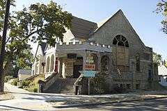
Boise |
|
| 124 |
St. Paul Missionary Baptist Church |
Upload image |
000000001982-10-29-0000October 29, 1982
(#82000247) |
124 Broadway Ave.
43°36′37″N 116°11′31″W / 43.610278°N 116.191944°W / 43.610278; -116.191944 (St. Paul Missionary Baptist Church) |
Boise |
|
| 125 |
Schick-Ostolasa Farmstead |
Upload image |
000000002006-08-23-0000August 23, 2006
(#06000710) |
5213 Dry Creek Rd.
43°43′23″N 116°14′53″W / 43.723056°N 116.248056°W / 43.723056; -116.248056 (Schick-Ostolasa Farmstead) |
Boise |
|
| 126 |
H. A. Schmelzel House |
Upload image |
000000001982-11-17-0000November 17, 1982
(#82000239) |
615 W. Hays St.
43°37′12″N 116°11′45″W / 43.62°N 116.195833°W / 43.62; -116.195833 (H. A. Schmelzel House) |
Boise |
|
| 127 |
Adolph Schreiber House |
Upload image |
000000001982-11-17-0000November 17, 1982
(#82000240) |
524 W. Franklin St.
43°37′09″N 116°11′43″W / 43.619167°N 116.195278°W / 43.619167; -116.195278 (Adolph Schreiber House) |
Boise |
|
| 128 |
Emerson and Lucretia Sensenig House |
Upload image |
000000001997-01-16-0000January 16, 1997
(#96001590) |
1519 W. Jefferson St.
43°37′21″N 116°12′34″W / 43.6225°N 116.209444°W / 43.6225; -116.209444 (Emerson and Lucretia Sensenig House) |
Boise |
|
| 129 |
O. F. Short House |
Upload image |
000000001980-05-23-0000May 23, 1980
(#80001289) |
West of Eagle on State Highway 44
43°42′07″N 116°21′40″W / 43.701944°N 116.361111°W / 43.701944; -116.361111 (O. F. Short House) |
Eagle |
|
| 130 |
William Sidenfaden House |
Upload image |
000000001982-11-17-0000November 17, 1982
(#82000241) |
906 Franklin St.
43°37′17″N 116°11′59″W / 43.621389°N 116.199722°W / 43.621389; -116.199722 (William Sidenfaden House) |
Boise |
|
| 131 |
W. A. Simpson House |
|
000000001982-11-17-0000November 17, 1982
(#82000242) |
1004 N. 10 St.
43°37′27″N 116°11′55″W / 43.624167°N 116.198611°W / 43.624167; -116.198611 (W. A. Simpson House) |
Boise |
|
| 132 |
Nathan Smith House |
Upload image |
000000001983-01-03-0000January 3, 1983
(#83000258) |
Broadway and Targhee
43°34′56″N 116°11′39″W / 43.582094°N 116.194231°W / 43.582094; -116.194231 (Nathan Smith House) |
Boise |
|
| 133 |
South Boise Fire Station |
|
000000001982-11-17-0000November 17, 1982
(#82000243) |
1011 Williams St.
43°35′26″N 116°11′40″W / 43.590577°N 116.194423°W / 43.590577; -116.194423 (South Boise Fire Station) |
Boise |
|
| 134 |
South Eighth Street Historic District |
|
000000001977-12-12-0000December 12, 1977
(#77000450) |
Roughly bounded by 8th, 9th, Miller, and Broad Sts.
43°36′47″N 116°12′21″W / 43.613056°N 116.205833°W / 43.613056; -116.205833 (South Eighth Street Historic District) |
Boise |
|
| 135 |
Almon W. and Dr. Mary E. Spaulding Ranch |
|
000000001994-11-25-0000November 25, 1994
(#94001363) |
3805 N. Cole Rd.
43°38′22″N 116°16′29″W / 43.639444°N 116.274722°W / 43.639444; -116.274722 (Almon W. and Dr. Mary E. Spaulding Ranch) |
Boise |
|
| 136 |
Star Camp |
Upload image |
000000002005-04-27-0000April 27, 2005
(#05000344) |
N. Star Rd. and W. 3rd St.
43°41′41″N 116°29′37″W / 43.694722°N 116.493611°W / 43.694722; -116.493611 (Star Camp) |
Star |
|
| 137 |
State Street Historic District |
|
000000001978-12-15-0000December 15, 1978
(#78001036) |
Jefferson, 2nd, and 3rd Sts.
43°36′55″N 116°11′36″W / 43.615278°N 116.193333°W / 43.615278; -116.193333 (State Street Historic District) |
Boise |
|
| 138 |
Louis Stephan House |
|
000000001982-11-17-0000November 17, 1982
(#82000248) |
1709 N. 18th St.
43°38′06″N 116°12′37″W / 43.635°N 116.210278°W / 43.635; -116.210278 (Louis Stephan House) |
Boise |
|
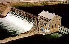
| 139 |
Swan Falls Dam and Power Plant |
|
000000001976-07-06-0000July 6, 1976
(#76000667) |
East of Murphy at the Snake River
43°14′35″N 116°22′48″W / 43.243056°N 116.38°W / 43.243056; -116.38 (Swan Falls Dam and Power Plant) |
Murphy |
|
| 140 |
Tolleth House |
Upload image |
000000001996-12-20-0000December 20, 1996
(#96001506) |
134 E. State Ave.
43°36′47″N 116°23′23″W / 43.613056°N 116.389722°W / 43.613056; -116.389722 (Tolleth House) |
Meridian |
|
| 141 |
John Tourtellotte Building |
|
000000001982-11-17-0000November 17, 1982
(#82000249) |
210-222 N. 10th St.
43°37′05″N 116°12′12″W / 43.618056°N 116.203333°W / 43.618056; -116.203333 (John Tourtellotte Building) |
Boise |
|
| 142 |
Bishop Daniel S. Tuttle House |
|
000000001980-12-04-0000December 4, 1980
(#80001291) |
512 N. 8th St.
43°37′09″N 116°11′56″W / 43.619167°N 116.198889°W / 43.619167; -116.198889 (Bishop Daniel S. Tuttle House) |
Boise |
|
| 143 |
Union Block and Montandon Buildings |
|
000000001979-03-07-0000March 7, 1979
(#79000767) |
8th and Idaho Sts.
43°36′59″N 116°12′04″W / 43.616389°N 116.201111°W / 43.616389; -116.201111 (Union Block and Montandon Buildings) |
Boise |
|
| 144 |
Union Pacific Mainline Depot |
|
000000001974-08-07-0000August 7, 1974
(#74000730) |
1701 Eastover Terrace
43°36′08″N 116°12′47″W / 43.602222°N 116.213056°W / 43.602222; -116.213056 (Union Pacific Mainline Depot) |
Boise |
|
| 145 |
Ustick School |
Upload image |
000000001982-10-29-0000October 29, 1982
(#82000250) |
2971 Mumbarto St.
43°37′54″N 116°19′21″W / 43.631667°N 116.3225°W / 43.631667; -116.3225 (Ustick School) |
Boise |
|
| 146 |
Charles and Martha Villeneuve House |
Upload image |
000000001990-11-13-0000November 13, 1990
(#90001731) |
7575 Moon Valley Rd.
43°41′20″N 116°26′51″W / 43.688889°N 116.4475°W / 43.688889; -116.4475 (Charles and Martha Villeneuve House) |
Eagle |
|
| 147 |
J. N. Wallace House |
Upload image |
000000001982-11-17-0000November 17, 1982
(#82000251) |
1202 Franklin St.
43°37′23″N 116°12′10″W / 43.623056°N 116.202778°W / 43.623056; -116.202778 (J. N. Wallace House) |
Boise |
|
| 148 |
Warm Springs Avenue Historic District |
|
000000001980-09-22-0000September 22, 1980
(#80001287) |
Warm Springs Ave.
43°36′24″N 116°10′50″W / 43.606667°N 116.180556°W / 43.606667; -116.180556 (Warm Springs Avenue Historic District) |
Boise |
|
| 149 |
C. H. Waymire Building |
|
000000001982-11-17-0000November 17, 1982
(#82000252) |
1521 N. 13th St.
43°37′49″N 116°12′10″W / 43.630278°N 116.202778°W / 43.630278; -116.202778 (C. H. Waymire Building) |
Boise |
|
| 150 |
Edward Welch House |
|
000000001982-11-17-0000November 17, 1982
(#82000253) |
1321 E. Jefferson St.
43°36′26″N 116°10′38″W / 43.607222°N 116.177222°W / 43.607222; -116.177222 (Edward Welch House) |
Boise |
|
| 151 |
Wellman Apartments |
|
000000001982-11-17-0000November 17, 1982
(#82000254) |
5th and Franklin Sts.
43°37′08″N 116°11′40″W / 43.618889°N 116.194444°W / 43.618889; -116.194444 (Wellman Apartments) |
Boise |
|
| 152 |
West Warm Springs Historic District |
Upload image |
000000001977-12-12-0000December 12, 1977
(#77000451) |
Warm Springs Ave. and Main, 1st, 2nd, and Idaho Sts.
43°36′42″N 116°11′40″W / 43.611667°N 116.194444°W / 43.611667; -116.194444 (West Warm Springs Historic District) |
Boise |
|
| 153 |
William Whitehead House |
Upload image |
000000002016-04-19-0000April 19, 2016
(#16000176) |
3921 W. Catalpa Dr.
43°39′19″N 116°14′17″W / 43.655185°N 116.238096°W / 43.655185; -116.238096 (William Whitehead House) |
Boise |
|
| 154 |
Whitney School |
Upload image |
000000001982-11-08-0000November 8, 1982
(#82000255) |
1609 S. Owyhee St.
43°35′19″N 116°13′25″W / 43.588611°N 116.223611°W / 43.588611; -116.223611 (Whitney School) |
Boise |
Replaced by new Whitney Elementary School in 2009
|
| 155 |
Wolters Double Houses |
Upload image |
000000001982-11-17-0000November 17, 1982
(#82000256) |
712-16 and 720-22 N. 8th St.
43°37′14″N 116°11′50″W / 43.620556°N 116.197222°W / 43.620556; -116.197222 (Wolters Double Houses) |
Boise |
|
| 156 |
Zurcher Apartments |
|
000000001982-11-17-0000November 17, 1982
(#82000257) |
102 S. 17th St.
43°37′16″N 116°12′48″W / 43.621111°N 116.213333°W / 43.621111; -116.213333 (Zurcher Apartments) |
Boise |
|