National Register of Historic Places listings in Fillmore County, Nebraska
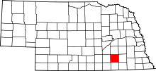
Location of Fillmore County in Nebraska
This is a list of the National Register of Historic Places listings in Fillmore County, Nebraska.
This is intended to be a complete list of the properties and districts on the National Register of Historic Places in Fillmore County, Nebraska, United States. The locations of National Register properties and districts for which the latitude and longitude coordinates are included below, may be seen in a map.[1]
There are 19 properties and districts listed on the National Register in the county.
- This National Park Service list is complete through NPS recent listings posted December 16, 2016.[2]
Current listings
| [3] | Name on the Register | Image | Date listed[4] | Location | City or town | Description |
|---|---|---|---|---|---|---|
| 1 | The Auditorium | |
(#88000950) |
160 N. 9th 40°31′36″N 97°36′10″W / 40.526667°N 97.602778°W |
Geneva | |
| 2 | Belle Prairie Township Hall & Strang Town Hall-Jail | 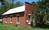 |
(#91001752) |
Main St. 40°24′50″N 97°35′13″W / 40.413889°N 97.586944°W |
Strang | |
| 3 | Big Blue River Bridge | 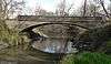 |
(#92000745) |
County road over the West Fork of the Big Blue River, 5 miles north and 1 mile west of Grafton 40°41′47″N 97°43′44″W / 40.696389°N 97.728889°W |
Grafton | |
| 4 | J.M. Burk House | 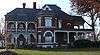 |
(#01000169) |
331 N. 11th St. 40°31′45″N 97°35′54″W / 40.529167°N 97.598333°W |
Geneva | |
| 5 | Cesko-narodni sin-Milligan Auditorium | 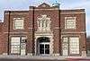 |
(#96000224) |
Southwestern corner of the junction of Main and Birch Sts. 40°30′08″N 97°23′30″W / 40.502222°N 97.391667°W |
Milligan | |
| 6 | Deering Bridge | 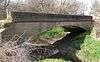 |
(#92000748) |
County road over School Creek, 2 miles north and 2 miles east of Sutton 40°38′25″N 97°49′29″W / 40.640309°N 97.824682°W |
Sutton | Exemplary 50-foot (15 m) concrete arch bridge built in 1916.[5] Extends into Clay County. |
| 7 | Dempster-Sloan House | 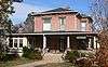 |
(#05000156) |
1212 M St. 40°32′01″N 97°35′49″W / 40.533611°N 97.596944°W |
Geneva | |
| 8 | Philip and Addie Ellis Eberhardt Farmstead | |
(#91000299) |
3 miles north of U.S. Route 6 40°40′51″N 97°27′34″W / 40.680833°N 97.459444°W |
Exeter | Farm buildings apparently no longer extant.[6] |
| 9 | Fairmont Army Airfield | 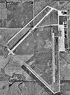 |
(#03000105) |
Approximately 2 miles south of Fairmont 40°35′22″N 97°34′35″W / 40.589444°N 97.576389°W |
Fairmont | |
| 10 | Fairmont Creamery Company Building | 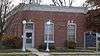 |
(#83003989) |
Southeast of 6th Ave. and F St. 40°38′06″N 97°35′05″W / 40.635°N 97.584722°W |
Fairmont | |
| 11 | Fillmore County Courthouse | _5.jpg) |
(#78001698) |
9th and G Sts. 40°31′30″N 97°36′09″W / 40.525°N 97.6025°W |
Geneva | |
| 12 | Lincoln Telephone & Telegraph Exchange Building in Fairmount | 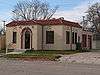 |
(#06000099) |
635 6th Ave. 40°38′05″N 97°35′07″W / 40.634722°N 97.585278°W |
Fairmont | |
| 13 | Maple Grove Sales Pavilion and Farrowing Barn | 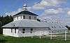 |
(#09000528) |
2408 Rd. W 40°22′50″N 97°22′49″W / 40.38056°N 97.38037°W |
Tobias | |
| 14 | Ohiowa Public School | |
(#05000725) |
202 S. Main St. 40°24′39″N 97°27′12″W / 40.410833°N 97.453333°W |
Ohiowa | |
| 15 | George W. Smith House | _5.JPG) |
(#86001022) |
12th St. between I and J Sts. 40°31′45″N 97°35′51″W / 40.529167°N 97.5975°W |
Geneva | |
| 16 | Stockholm Swedish Lutheran Church and Cemetery | 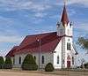 |
(#95000798) |
2.5 miles west and 0.5 miles south of Shickley 40°24′36″N 97°46′41″W / 40.41°N 97.778056°W |
Shickley | |
| 17 | Strang School District No. 36 | 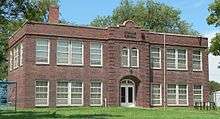 |
(#91001753) |
Main St. 40°24′43″N 97°35′13″W / 40.411944°N 97.586944°W |
Strang | |
| 18 | US Post Office-Geneva | _from_E.JPG) |
(#92000478) |
202 N. 9th St. 40°31′38″N 97°36′11″W / 40.527316°N 97.603106°W |
Geneva | One of 12 Nebraska post offices featuring a Section of Fine Arts mural, "Building a Sod House" (1941) by Edward Chávez.[7] |
| 19 | Warner's Filling Station and House | |
(#06000606) |
737 and 745 G St. 40°31′31″N 97°36′17″W / 40.525278°N 97.604722°W |
Geneva |
See also
- List of National Historic Landmarks in Nebraska
- National Register of Historic Places listings in Nebraska
External links
| Wikimedia Commons has media related to National Register of Historic Places in Fillmore County, Nebraska. |
- Nebraska National Register Sites in Fillmore County–Nebraska State Historical Society
References
- ↑ The latitude and longitude information provided in this table was derived originally from the National Register Information System, which has been found to be fairly accurate for about 99% of listings. For about 1% of NRIS original coordinates, experience has shown that one or both coordinates are typos or otherwise extremely far off; some corrections may have been made. A more subtle problem causes many locations to be off by up to 150 yards, depending on location in the country: most NRIS coordinates were derived from tracing out latitude and longitudes off of USGS topographical quadrant maps created under the North American Datum of 1927, which differs from the current, highly accurate WGS84 GPS system used by most on-line maps. Chicago is about right, but NRIS longitudes in Washington are higher by about 4.5 seconds, and are lower by about 2.0 seconds in Maine. Latitudes differ by about 1.0 second in Florida. Some locations in this table may have been corrected to current GPS standards.
- ↑ "National Register of Historic Places: Weekly List Actions". National Park Service, United States Department of the Interior. Retrieved on December 16, 2016.
- ↑ Numbers represent an ordering by significant words. Various colorings, defined here, differentiate National Historic Landmarks and historic districts from other NRHP buildings, structures, sites or objects.
- ↑ The eight-digit number below each date is the number assigned to each location in the National Register Information System database, which can be viewed by clicking the number.
- ↑ Hess, Demian (1991-06-30). "National Register of Historic Places Registration Form: Deering Bridge" (PDF). Retrieved 2013-02-15.
- ↑ See photos covering quarter-section at Commons:Category:Eberhardt farmstead site (Fillmore County, Nebraska)
- ↑ Ahlgren, Carol (August 1991). "National Register of Historic Places Multiple Property Documentation Form: Nebraska Post Offices Which Contain Section Artwork (1938-1942)" (PDF). Retrieved 2013-01-28.
| Topics | |
|---|---|
| Lists by states |
|
| Lists by insular areas | |
| Lists by associated states | |
| Other areas | |
| |
Municipalities and communities of Fillmore County, Nebraska, United States | ||
|---|---|---|
| City | ||
| Villages | ||
| Townships | ||
| Unincorporated communities | ||
| Ghost town | ||
This article is issued from Wikipedia - version of the 9/8/2016. The text is available under the Creative Commons Attribution/Share Alike but additional terms may apply for the media files.