National Register of Historic Places listings in Jackson County, Oklahoma
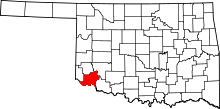
Location of Jackson County in Oklahoma
This is a list of the National Register of Historic Places listings in Jackson County, Oklahoma.
This is intended to be a complete list of the properties on the National Register of Historic Places in Jackson County, Oklahoma, United States. The locations of National Register properties for which the latitude and longitude coordinates are included below, may be seen in a map.[1]
There are 9 properties listed on the National Register in the county.
- This National Park Service list is complete through NPS recent listings posted December 2, 2016.[2]
- Adair
- Alfalfa
- Atoka
- Beaver
- Beckham
- Blaine
- Bryan
- Caddo
- Canadian
- Carter
- Cherokee
- Choctaw
- Cimarron
- Cleveland
- Coal
- Comanche
- Cotton
- Craig
- Creek
- Custer
- Delaware
- Dewey
- Ellis
- Garfield
- Garvin
- Grady
- Grant
- Greer
- Harmon
- Harper
- Haskell
- Hughes
- Jackson
- Jefferson
- Johnston
- Kay
- Kingfisher
- Kiowa
- Latimer
- Le Flore
- Lincoln
- Logan
- Love
- Major
- Marshall
- Mayes
- McClain
- McCurtain
- McIntosh
- Murray
- Muskogee
- Noble
- Nowata
- Okfuskee
- Oklahoma
- Okmulgee
- Osage
- Ottawa
- Pawnee
- Payne
- Pittsburg
- Pontotoc
- Pottawatomie
- Pushmataha
- Roger Mills
- Rogers
- Seminole
- Sequoyah
- Stephens
- Texas
- Tillman
- Tulsa
- Wagoner
- Washington
- Washita
- Woods
- Woodward
Current listings
| [3] | Name on the Register[4] | Image | Date listed[5] | Location | City or town | Description |
|---|---|---|---|---|---|---|
| 1 | W. C. Baker House |  |
(#05001417) |
301 E. Commerce 34°38′21″N 99°19′50″W / 34.639167°N 99.330556°W |
Altus | |
| 2 | Cross S Ranch Headquarters | Upload image | (#06000119) |
1.3 miles (2.1 km) west and 0.4 miles (0.64 km) north of the junction of County Roads N199 and E1750 34°29′05″N 99°26′11″W / 34.484722°N 99.436389°W |
Olustee | |
| 3 | Frazer Cemetery | 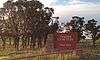 |
(#11000336) |
0.5 miles (0.80 km) south of junction of County Rd. 202 & US 62, 2 miles (3.2 km) west of the Jackson County Courthouse 34°37′49″N 99°22′10″W / 34.630278°N 99.369444°W |
Altus | |
| 4 | Fullerton Dam | Upload image | (#76001562) |
7 miles (11 km) northwest of Olustee 34°37′27″N 99°29′27″W / 34.624167°N 99.490833°W |
Olustee | |
| 5 | Elmer and Lela Garnett House |  |
(#11000337) |
801 E. Commerce St. 34°38′21″N 99°19′28″W / 34.639167°N 99.324444°W |
Altus | |
| 6 | Jackson County Courthouse and Jail |  |
(#84003064) |
Main St. and Broadway; also 101 N. Main St. 34°38′18″N 99°20′03″W / 34.638333°N 99.334167°W |
Altus | 101 Main represents a boundary increase of September 4, 2008 (#08000901) |
| 7 | Olustee Public Library and Park |  |
(#06000116) |
Southern side of 4th St. between C and D Sts. 34°32′53″N 99°25′22″W / 34.548056°N 99.422778°W |
Olustee | |
| 8 | Perryman Ranch Headquarters | 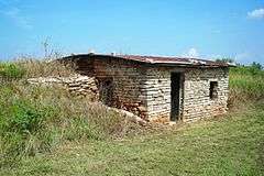 |
(#07000260) |
0.2 miles (0.32 km) miles east of the junction of County Roads N193 and E159 34°42′39″N 99°31′29″W / 34.710833°N 99.524722°W |
East Duke | |
| 9 | Wichita Falls & Northwestern Railroad Passenger Depot | 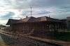 |
(#08000851) |
523 S. Main St. 34°38′00″N 99°20′02″W / 34.63341°N 99.33395°W |
Altus |
See also
| Wikimedia Commons has media related to National Register of Historic Places in Jackson County, Oklahoma. |
- List of National Historic Landmarks in Oklahoma
- National Register of Historic Places listings in Oklahoma
References
- ↑ The latitude and longitude information provided in this table was derived originally from the National Register Information System, which has been found to be fairly accurate for about 99% of listings. For about 1% of NRIS original coordinates, experience has shown that one or both coordinates are typos or otherwise extremely far off; some corrections may have been made. A more subtle problem causes many locations to be off by up to 150 yards, depending on location in the country: most NRIS coordinates were derived from tracing out latitude and longitudes off of USGS topographical quadrant maps created under the North American Datum of 1927, which differs from the current, highly accurate WGS84 GPS system used by most on-line maps. Chicago is about right, but NRIS longitudes in Washington are higher by about 4.5 seconds, and are lower by about 2.0 seconds in Maine. Latitudes differ by about 1.0 second in Florida. Some locations in this table may have been corrected to current GPS standards.
- ↑ "National Register of Historic Places: Weekly List Actions". National Park Service, United States Department of the Interior. Retrieved on December 2, 2016.
- ↑ Numbers represent an ordering by significant words. Various colorings, defined here, differentiate National Historic Landmarks and historic districts from other NRHP buildings, structures, sites or objects.
- ↑ National Park Service (2009-03-13). "National Register Information System". National Register of Historic Places. National Park Service.
- ↑ The eight-digit number below each date is the number assigned to each location in the National Register Information System database, which can be viewed by clicking the number.
| Topics | |
|---|---|
| Lists by states |
|
| Lists by insular areas | |
| Lists by associated states | |
| Other areas | |
| |
Municipalities and communities of Jackson County, Oklahoma, United States | ||
|---|---|---|
| City | | |
| Towns | ||
| Unincorporated communities | ||
| Ghost towns | ||
This article is issued from Wikipedia - version of the 5/15/2016. The text is available under the Creative Commons Attribution/Share Alike but additional terms may apply for the media files.