National Register of Historic Places listings in Garvin County, Oklahoma
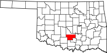
Location of Garvin County in Oklahoma
This is a list of the National Register of Historic Places listings in Garvin County, Oklahoma.
This is intended to be a complete list of the properties and districts on the National Register of Historic Places in Garvin County, Oklahoma, United States. The locations of National Register properties and districts for which the latitude and longitude coordinates are included below, may be seen in a map.[1]
There are 11 properties and districts listed on the National Register in the county.
- This National Park Service list is complete through NPS recent listings posted December 2, 2016.[2]
- Adair
- Alfalfa
- Atoka
- Beaver
- Beckham
- Blaine
- Bryan
- Caddo
- Canadian
- Carter
- Cherokee
- Choctaw
- Cimarron
- Cleveland
- Coal
- Comanche
- Cotton
- Craig
- Creek
- Custer
- Delaware
- Dewey
- Ellis
- Garfield
- Garvin
- Grady
- Grant
- Greer
- Harmon
- Harper
- Haskell
- Hughes
- Jackson
- Jefferson
- Johnston
- Kay
- Kingfisher
- Kiowa
- Latimer
- Le Flore
- Lincoln
- Logan
- Love
- Major
- Marshall
- Mayes
- McClain
- McCurtain
- McIntosh
- Murray
- Muskogee
- Noble
- Nowata
- Okfuskee
- Oklahoma
- Okmulgee
- Osage
- Ottawa
- Pawnee
- Payne
- Pittsburg
- Pontotoc
- Pottawatomie
- Pushmataha
- Roger Mills
- Rogers
- Seminole
- Sequoyah
- Stephens
- Texas
- Tillman
- Tulsa
- Wagoner
- Washington
- Washita
- Woods
- Woodward
Current listings
| [3] | Name on the Register[4] | Image | Date listed[5] | Location | City or town | Description |
|---|---|---|---|---|---|---|
| 1 | Antioch Dependent School District No. 15 | 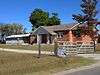 |
(#04001333) |
0.5 miles west of the junction of Antioch Rd and State Highway 74 34°43′30″N 97°24′42″W / 34.725°N 97.411667°W |
Elmore City | |
| 2 | Erin Springs Mansion |  |
(#70000534) |
South of the Washita River 34°48′30″N 97°36′16″W / 34.808333°N 97.604444°W |
Erin Springs | |
| 3 | Eskridge Hotel | 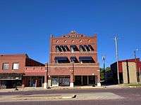 |
(#79001994) |
114 E. Robert S. Kerr St. 34°38′36″N 97°10′10″W / 34.643333°N 97.169444°W |
Wynnewood | |
| 4 | First National Bank Building | 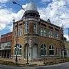 |
(#01000659) |
100 W. Main 34°47′44″N 96°57′44″W / 34.795556°N 96.962222°W |
Stratford | |
| 5 | Fort Arbuckle Site | Upload image | (#72001064) |
About 0.5 miles north of Hoover on State Highway 7 34°31′39″N 97°15′00″W / 34.5275°N 97.25°W |
Hoover | |
| 6 | Garvin County Courthouse | 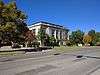 |
(#85002758) |
Courthouse Sq. and Grant Ave. 34°44′25″N 97°13′18″W / 34.740278°N 97.221667°W |
Pauls Valley | |
| 7 | Hargis-Mitchell-Cochran House | 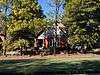 |
(#82003684) |
204 E. Robert S. Kerr St. 34°38′35″N 97°10′08″W / 34.643056°N 97.168889°W |
Wynnewood | |
| 8 | Initial Point | Upload image | (#70000533) |
About 7.5 miles west of Davis on the Garvin/Murray county line 34°30′24″N 97°14′49″W / 34.506667°N 97.246944°W |
Davis | Extends into Murray County |
| 9 | Moore-Settle House | 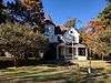 |
(#83002086) |
508 E. Cherokee St. 34°38′34″N 97°09′50″W / 34.642778°N 97.163889°W |
Wynnewood | |
| 10 | Pauls Valley Historic District | 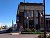 |
(#79001993) |
Roughly bounded by railroad tracks, Grant Ave., and Joy St. 34°44′24″N 97°13′10″W / 34.74°N 97.219444°W |
Pauls Valley | |
| 11 | Santa Fe Depot of Lindsay | 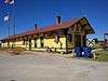 |
(#86000863) |
120 N. Main 34°50′14″N 97°36′09″W / 34.837222°N 97.6025°W |
Lindsay |
See also
| Wikimedia Commons has media related to National Register of Historic Places in Garvin County, Oklahoma. |
- List of National Historic Landmarks in Oklahoma
- National Register of Historic Places listings in Oklahoma
References
- ↑ The latitude and longitude information provided in this table was derived originally from the National Register Information System, which has been found to be fairly accurate for about 99% of listings. For about 1% of NRIS original coordinates, experience has shown that one or both coordinates are typos or otherwise extremely far off; some corrections may have been made. A more subtle problem causes many locations to be off by up to 150 yards, depending on location in the country: most NRIS coordinates were derived from tracing out latitude and longitudes off of USGS topographical quadrant maps created under the North American Datum of 1927, which differs from the current, highly accurate WGS84 GPS system used by most on-line maps. Chicago is about right, but NRIS longitudes in Washington are higher by about 4.5 seconds, and are lower by about 2.0 seconds in Maine. Latitudes differ by about 1.0 second in Florida. Some locations in this table may have been corrected to current GPS standards.
- ↑ "National Register of Historic Places: Weekly List Actions". National Park Service, United States Department of the Interior. Retrieved on December 2, 2016.
- ↑ Numbers represent an ordering by significant words. Various colorings, defined here, differentiate National Historic Landmarks and historic districts from other NRHP buildings, structures, sites or objects.
- ↑ National Park Service (2009-03-13). "National Register Information System". National Register of Historic Places. National Park Service.
- ↑ The eight-digit number below each date is the number assigned to each location in the National Register Information System database, which can be viewed by clicking the number.
| Topics | |
|---|---|
| Lists by states |
|
| Lists by insular areas | |
| Lists by associated states | |
| Other areas | |
| |
Municipalities and communities of Garvin County, Oklahoma, United States | ||
|---|---|---|
| Cities | | |
| Towns | ||
| Unincorporated communities | ||
| Ghost town | ||
| Footnotes | ‡This populated place also has portions in an adjacent county or counties | |
This article is issued from Wikipedia - version of the 5/15/2016. The text is available under the Creative Commons Attribution/Share Alike but additional terms may apply for the media files.