National Register of Historic Places listings in Phillips County, Kansas
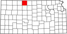
Location of Phillips County in Kansas
This is a list of the National Register of Historic Places listings in Phillips County, Kansas.
This is intended to be a complete list of the properties and districts on the National Register of Historic Places in Phillips County, Kansas, United States. The locations of National Register properties and districts for which the latitude and longitude coordinates are included below, may be seen in a map.[1]
There are 9 properties and districts listed on the National Register in the county.
- This National Park Service list is complete through NPS recent listings posted December 16, 2016.[2]
Current listings
| [3] | Name on the Register[4] | Image | Date listed[5] | Location | City or town | Description |
|---|---|---|---|---|---|---|
| 1 | Agra Consolidated School | |
(#05001246) |
941 Kansas Ave. 39°45′41″N 99°06′52″W / 39.761286°N 99.114555°W |
Agra | Now Thunder Ridge Middle School[6] |
| 2 | Agra Lake and Park | _dam_bldg_1.JPG) |
(#08000616) |
¼ mile north of U.S. Route 36 on the west edge of Agra. 39°45′41″N 99°07′34″W / 39.761389°N 99.126111°W |
Agra | |
| 3 | Battle Creek King Post Truss Bridge |  |
(#03000362) |
W. Eagle Rd., 3.0 miles east of its junction with Washington Rd. 39°56′39″N 99°28′47″W / 39.944072°N 99.479587°W |
Long Island | |
| 4 | Hoff School District No. 42 |  |
(#10001140) |
Near intersection of E. Union Rd. and E. 1300 Rd. 39°42′50″N 99°05′05″W / 39.713757°N 99.084618°W |
Kirwin | Public Schools of Kansas MPS |
| 5 | Jack Creek Kingpost | |
(#89002188) |
Eagle Rd east of West 600 Rd 39°56′39″N 99°26′20″W / 39.944107°N 99.438804°W |
Long Island | |
| 6 | Kirwin City Hall | 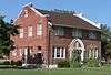 |
(#06000471) |
1st and Main Sts. 39°40′23″N 99°07′20″W / 39.673056°N 99.122222°W |
Kirwin | |
| 7 | Long Island School | _from_SE_1.JPG) |
(#05000551) |
Washington Street 39°56′47″N 99°32′04″W / 39.946472°N 99.534532°W |
Long Island | |
| 8 | Phillipsburg Community Building | |
(#10000845) |
425 F St. 39°45′26″N 99°19′22″W / 39.757301°N 99.322691°W |
Phillipsburg | New Deal-Era Resources of Kansas MPS |
| 9 | Pleasant Ridge Church | _from_SW_2.JPG) |
(#05001204) |
381 E. Buffalo Rd. 39°59′15″N 99°15′27″W / 39.987427°N 99.257433°W |
Phillipsburg |
See also
| Wikimedia Commons has media related to National Register of Historic Places in Phillips County, Kansas. |
- List of National Historic Landmarks in Kansas
- National Register of Historic Places listings in Kansas
References
- ↑ The latitude and longitude information provided in this table was derived originally from the National Register Information System, which has been found to be fairly accurate for about 99% of listings. For about 1% of NRIS original coordinates, experience has shown that one or both coordinates are typos or otherwise extremely far off; some corrections may have been made. A more subtle problem causes many locations to be off by up to 150 yards, depending on location in the country: most NRIS coordinates were derived from tracing out latitude and longitudes off of USGS topographical quadrant maps created under the North American Datum of 1927, which differs from the current, highly accurate WGS84 GPS system used by most on-line maps. Chicago is about right, but NRIS longitudes in Washington are higher by about 4.5 seconds, and are lower by about 2.0 seconds in Maine. Latitudes differ by about 1.0 second in Florida. Some locations in this table may have been corrected to current GPS standards.
- ↑ "National Register of Historic Places: Weekly List Actions". National Park Service, United States Department of the Interior. Retrieved on December 16, 2016.
- ↑ Numbers represent an ordering by significant words. Various colorings, defined here, differentiate National Historic Landmarks and historic districts from other NRHP buildings, structures, sites or objects.
- ↑ National Park Service (2009-03-13). "National Register Information System". National Register of Historic Places. National Park Service.
- ↑ The eight-digit number below each date is the number assigned to each location in the National Register Information System database, which can be viewed by clicking the number.
- ↑ "Thunder Ridge Schools." Thunder Ridge Schools home. Retrieved 2014-09-07.

Municipalities and communities of Phillips County, Kansas, United States | ||
|---|---|---|
| Cities | | |
| Unincorporated communities | ||
This article is issued from Wikipedia - version of the 6/4/2016. The text is available under the Creative Commons Attribution/Share Alike but additional terms may apply for the media files.