National Register of Historic Places listings in Crawford County, Kansas
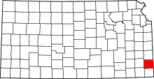
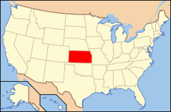
Location of Crawford County in Kansas
This is a list of the National Register of Historic Places listings in Crawford County, Kansas.
This is intended to be a complete list of the properties and districts on the National Register of Historic Places in Crawford County, Kansas, United States. The locations of National Register properties and districts for which the latitude and longitude coordinates are included below, may be seen in a map.[1]
There are 19 properties and districts listed on the National Register in the county.
- This National Park Service list is complete through NPS recent listings posted December 16, 2016.[2]
Current listings
| [3] |
Name on the Register[4] |
Image |
Date listed[5] |
Location |
City or town |
Description |
|---|
| 1 |
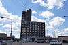
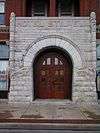
Besse Hotel |
|
000000002008-04-16-0000April 16, 2008
(#08000300) |
121 E. 4th St.
37°31′14″N 94°50′36″W / 37.520556°N 94.843333°W / 37.520556; -94.843333 (Besse Hotel) |
Pittsburg |
|
| 2 |
Cato District No. 4 School |
Upload image |
000000002006-09-06-0000September 6, 2006
(#06000771) |
Junction of 200th St. and 720th Ave.
37°40′01″N 94°44′30″W / 37.666861°N 94.741528°W / 37.666861; -94.741528 (Cato District No. 4 School) |
Cato |
|
| 3 |
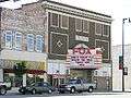
Colonial Fox Theatre |
|
000000002008-04-16-0000April 16, 2008
(#08000301) |
409 N. Broadway
37°24′40″N 94°42′17″W / 37.411111°N 94.704722°W / 37.411111; -94.704722 (Colonial Fox Theatre) |
Pittsburg |
|
| 4 |
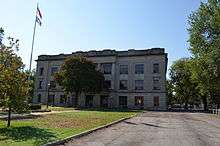
Crawford County Courthouse |
|
000000002009-04-22-0000April 22, 2009
(#09000225) |
111 E. Forest, Courthouse Square
37°30′39″N 94°50′36″W / 37.510839°N 94.843219°W / 37.510839; -94.843219 (Crawford County Courthouse) |
Girard |
|
| 5 |
First Presbyterian Church |
Upload image |
000000002009-07-08-0000July 8, 2009
(#09000496) |
202 N. Summit
37°30′39″N 94°50′36″W / 37.510878°N 94.843383°W / 37.510878; -94.843383 (First Presbyterian Church) |
Girard |
|
| 6 |
Fourth and Broadway Historic District |
Upload image |
000000002016-10-11-0000October 11, 2016
(#16000703) |
401-424 N. Broadway, 105 and 121 E. 4th Sts.
37°24′41″N 94°42′17″W / 37.411262°N 94.704792°W / 37.411262; -94.704792 (Fourth and Broadway Historic District) |
Pittsburg |
|
| 7 |
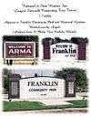
Franklin Sidewalk |
|
000000002007-03-16-0000March 16, 2007
(#07000143) |
Parallel to Business Route 69 between Franklin and Arma
37°32′00″N 94°42′17″W / 37.533333°N 94.704750°W / 37.533333; -94.704750 (Franklin Sidewalk) |
Franklin |
|
| 8 |
Girard Carnegie Library |
|
000000001987-06-25-0000June 25, 1987
(#87000952) |
128 W. Prairie
37°30′37″N 94°50′42″W / 37.510278°N 94.845°W / 37.510278; -94.845 (Girard Carnegie Library) |
Girard |
|
| 9 |
Hotel Stilwell |
|
000000001980-04-30-0000April 30, 1980
(#80001464) |
707 Broadway
37°24′51″N 94°42′19″W / 37.414167°N 94.705278°W / 37.414167; -94.705278 (Hotel Stilwell) |
Pittsburg |
|
| 10 |
Hudgeon Bridge |
Upload image |
000000001985-07-02-0000July 2, 1985
(#85001433) |
10 miles south and 3.2 miles west of Girard
37°22′08″N 94°53′56″W / 37.368889°N 94.898889°W / 37.368889; -94.898889 (Hudgeon Bridge) |
Girard |
|
| 11 |
Little Walnut Creek Bowstring |
Upload image |
000000001990-01-04-0000January 4, 1990
(#89002174) |
Over Little Walnut Creek, northeast of Walnut
37°38′43″N 95°02′45″W / 37.645278°N 95.045833°W / 37.645278; -95.045833 (Little Walnut Creek Bowstring) |
Walnut |
|
| 12 |
Pittsburg Public Library |
|
000000001977-11-09-0000November 9, 1977
(#77000577) |
4th and Walnut Sts.
37°24′40″N 94°42′26″W / 37.411111°N 94.707222°W / 37.411111; -94.707222 (Pittsburg Public Library) |
Pittsburg |
|
| 13 |
J. E. Raymond House |
Upload image |
000000002007-04-03-0000April 3, 2007
(#07000255) |
301 Osage St.
37°30′28″N 94°50′43″W / 37.507778°N 94.845278°W / 37.507778; -94.845278 (J. E. Raymond House) |
Girard |
|
| 14 |
S-W Supply Company |
Upload image |
000000002009-05-21-0000May 21, 2009
(#09000348) |
215 E. Prairie Ave.
37°30′34″N 94°50′29″W / 37.50951°N 94.84145°W / 37.50951; -94.84145 (S-W Supply Company) |
Girard |
|
| 15 |
St. John's Episcopal Church |
Upload image |
000000002009-04-22-0000April 22, 2009
(#09000226) |
Southeastern corner of Buffalo and Summit
37°30′29″N 94°50′35″W / 37.507975°N 94.842986°W / 37.507975; -94.842986 (St. John's Episcopal Church) |
Girard |
|
| 16 |
State Bank of Girard |
Upload image |
000000002009-08-07-0000August 7, 2009
(#09000349) |
105 E. Prairie
37°30′34″N 94°50′36″W / 37.509553°N 94.843308°W / 37.509553; -94.843308 (State Bank of Girard) |
Girard |
|
| 17 |
Washington Grade School |
Upload image |
000000002008-04-16-0000April 16, 2008
(#08000302) |
209 S. Locust St.
37°24′26″N 94°42′12″W / 37.407222°N 94.703333°W / 37.407222; -94.703333 (Washington Grade School) |
Pittsburg |
|
| 18 |
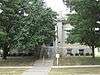
Julius A. Wayland House |
Upload image |
000000001976-11-21-0000November 21, 1976
(#76000819) |
721 N. Summit
37°31′14″N 94°50′36″W / 37.520556°N 94.843333°W / 37.520556; -94.843333 (Julius A. Wayland House) |
Girard |
|
| 19 |
Whitesitt-Shirk Historic District |
Upload image |
000000002002-03-20-0000March 20, 2002
(#02000204) |
116 E. Lindburg and 120 E. Lindburg
37°23′31″N 94°42′15″W / 37.391944°N 94.704167°W / 37.391944; -94.704167 (Whitesitt-Shirk Historic District) |
Pittsburg |
|
See also
References
- ↑ The latitude and longitude information provided in this table was derived originally from the National Register Information System, which has been found to be fairly accurate for about 99% of listings. For about 1% of NRIS original coordinates, experience has shown that one or both coordinates are typos or otherwise extremely far off; some corrections may have been made. A more subtle problem causes many locations to be off by up to 150 yards, depending on location in the country: most NRIS coordinates were derived from tracing out latitude and longitudes off of USGS topographical quadrant maps created under the North American Datum of 1927, which differs from the current, highly accurate WGS84 GPS system used by most on-line maps. Chicago is about right, but NRIS longitudes in Washington are higher by about 4.5 seconds, and are lower by about 2.0 seconds in Maine. Latitudes differ by about 1.0 second in Florida. Some locations in this table may have been corrected to current GPS standards.
- ↑ "National Register of Historic Places: Weekly List Actions". National Park Service, United States Department of the Interior. Retrieved on December 16, 2016.
- ↑ Numbers represent an ordering by significant words. Various colorings, defined here, differentiate National Historic Landmarks and historic districts from other NRHP buildings, structures, sites or objects.
- ↑ National Park Service (2009-03-13). "National Register Information System". National Register of Historic Places. National Park Service.
- ↑ The eight-digit number below each date is the number assigned to each location in the National Register Information System database, which can be viewed by clicking the number.