| [3] |
Name on the Register[4] |
Image |
Date listed[5] |
Location |
City or town |
Description |
|---|
| 1 |
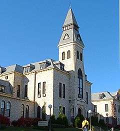
Anderson Hall |
|
000000001980-11-28-0000November 28, 1980
(#80001471) |
Kansas State University campus
39°11′19″N 96°34′50″W / 39.188611°N 96.580556°W / 39.188611; -96.580556 (Anderson Hall) |
Manhattan |
|
| 2 |
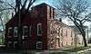
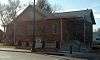
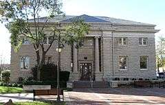
Bethel A.M.E. Church |
|
000000002012-05-30-0000May 30, 2012
(#12000301) |
401 Yuma St.
39°10′30″N 96°33′44″W / 39.174929°N 96.562198°W / 39.174929; -96.562198 (Bethel A.M.E. Church) |
Manhattan |
|
| 3 |
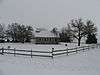
Bluemont Youth Cabin |
Upload image |
000000002014-01-08-0000January 8, 2014
(#13001044) |
NE. of 5th & Bertrand Sts. in Goodnow Park
Coordinates missing |
Manhattan |
Part of the New Deal-Era Resources of Kansas MPS
|
| 4 |
Community House |
|
000000002006-11-21-0000November 21, 2006
(#06001051) |
120 N. 4th St.
39°10′55″N 96°33′42″W / 39.181944°N 96.561667°W / 39.181944; -96.561667 (Community House) |
Manhattan |
|
| 5 |
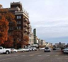
Downtown Manhattan Historic District |
|
000000002007-10-02-0000October 2, 2007
(#06001240) |
Generally including the blocks between Humboldt and Pierre Sts. from 3rd to 5th Sts.
39°10′44″N 96°33′42″W / 39.178889°N 96.561667°W / 39.178889; -96.561667 (Downtown Manhattan Historic District) |
Manhattan |
|
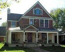
| 6 |
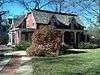
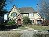
Mattie M. Elliot House |
|
000000001995-06-02-0000June 2, 1995
(#95000672) |
600 Houston St.
39°10′42″N 96°33′55″W / 39.178333°N 96.565278°W / 39.178333; -96.565278 (Mattie M. Elliot House) |
Manhattan |
|
| 7 |
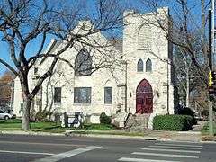
First Congregational Church |
|
000000002008-11-13-0000November 13, 2008
(#08001068) |
700 Poyntz Ave.
39°10′46″N 96°34′02″W / 39.179528°N 96.567155°W / 39.179528; -96.567155 (First Congregational Church) |
Manhattan |
|
| 8 |
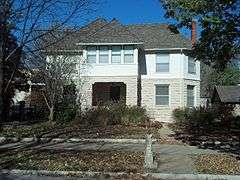
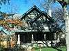
Leslie A. Fitz House |
|
000000002005-06-08-0000June 8, 2005
(#05000543) |
1014 Houston St.
39°10′43″N 96°34′21″W / 39.178661°N 96.5725°W / 39.178661; -96.5725 (Leslie A. Fitz House) |
Manhattan |
|
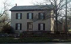
| 9 |
Goodnow House |
|
000000001971-02-24-0000February 24, 1971
(#71000326) |
2301 Claflin Rd.
39°11′34″N 96°35′44″W / 39.192896°N 96.595587°W / 39.192896; -96.595587 (Goodnow House) |
Manhattan |
|
| 10 |
Grimes House |
Upload image |
000000001997-05-09-0000May 9, 1997
(#97000409) |
203 Delaware St.
39°10′58″N 96°35′14″W / 39.182778°N 96.587222°W / 39.182778; -96.587222 (Grimes House) |
Manhattan |
|
| 11 |
Houston and Pierre Streets Residential Historic District |
Upload image |
000000002009-02-18-0000February 18, 2009
(#09000031) |
Bounded by S. 5th St., Pierre St., S. 9th St., and Houston St.
39°10′40″N 96°34′01″W / 39.177789°N 96.566825°W / 39.177789; -96.566825 (Houston and Pierre Streets Residential Historic District) |
Manhattan |
|
| 12 |
Samuel D. Houston House |
Upload image |
000000002007-01-17-0000January 17, 2007
(#06001246) |
3624 Anderson Ave.
39°11′20″N 96°37′50″W / 39.188875°N 96.630456°W / 39.188875; -96.630456 (Samuel D. Houston House) |
Manhattan |
|
| 13 |
Hulse-Daughters House |
|
000000002007-06-27-0000June 27, 2007
(#07000601) |
617 Colorado St.
39°10′41″N 96°33′59″W / 39.178056°N 96.566389°W / 39.178056; -96.566389 (Hulse-Daughters House) |
Manhattan |
|
| 14 |
Jesse Ingraham House |
Upload image |
000000002014-01-08-0000January 8, 2014
(#13001045) |
1724 Fairchild Ave.
Coordinates missing |
Manhattan |
Part of the Late 19th Century Vernacular Stone Houses in Manhattan, Kansas MPS
|
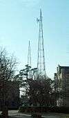
| 15 |
KSAC Radio Towers |
|
000000001983-08-27-0000August 27, 1983
(#83000437) |
Kansas State University campus
39°11′13″N 96°34′53″W / 39.1869051°N 96.5814435°W / 39.1869051; -96.5814435 (KSAC Radio Towers) |
Manhattan |
|
| 16 |
Francis Byron (Barney) Kimble House |
Upload image |
000000002015-10-02-0000October 2, 2015
(#15000691) |
720 Poyntz Ave.
39°10′46″N 96°34′04″W / 39.1794°N 96.5678°W / 39.1794; -96.5678 (Francis Byron (Barney) Kimble House) |
Manhattan |
|
| 17 |
Lyda-Jean Apartments |
|
000000002004-04-28-0000April 28, 2004
(#04000368) |
501 Houston St.
39°10′48″N 96°33′50″W / 39.18°N 96.563889°W / 39.18; -96.563889 (Lyda-Jean Apartments) |
Manhattan |
|
| 18 |
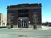
Manhattan Carnegie Library Building |
|
000000001987-06-25-0000June 25, 1987
(#87000970) |
5th St. and Poyntz Ave.
39°10′46″N 96°33′48″W / 39.179444°N 96.563333°W / 39.179444; -96.563333 (Manhattan Carnegie Library Building) |
Manhattan |
|
| 19 |
McFarlane-Wareham House |
Upload image |
000000002004-07-21-0000July 21, 2004
(#04000724) |
1906 Leavenworth St.
39°11′01″N 96°35′13″W / 39.183611°N 96.586944°W / 39.183611; -96.586944 (McFarlane-Wareham House) |
Manhattan |
|
| 20 |
Persons Barn and Granary |
Upload image |
000000002009-01-22-0000January 22, 2009
(#08001351) |
2103 Fort Riley Boulevard
39°10′24″N 96°35′27″W / 39.173433°N 96.590711°W / 39.173433; -96.590711 (Persons Barn and Granary) |
Manhattan |
|
| 21 |
Jeremiah Platt House |
|
000000001981-05-20-0000May 20, 1981
(#81000281) |
2005 Claflin Rd.
39°11′33″N 96°35′23″W / 39.1925°N 96.589722°W / 39.1925; -96.589722 (Jeremiah Platt House) |
Manhattan |
|
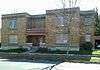
| 22 |
Riley County Courthouse |
|
000000002005-11-15-0000November 15, 2005
(#05001249) |
100 Courthouse Plaza
39°10′54″N 96°33′47″W / 39.181667°N 96.563056°W / 39.181667; -96.563056 (Riley County Courthouse) |
Manhattan |
|
| 23 |
Rocky Ford School |
|
000000002012-01-20-0000January 20, 2012
(#11001033) |
1669 Barnes Rd.
39°13′44″N 96°35′01″W / 39.229027°N 96.583611°W / 39.229027; -96.583611 (Rocky Ford School) |
Manhattan |
|
| 24 |
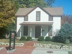
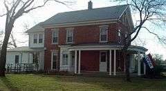
Damon Runyon House |
|
000000002004-12-02-0000December 2, 2004
(#04001282) |
400 Osage St.
39°11′04″N 96°33′43″W / 39.184444°N 96.561944°W / 39.184444; -96.561944 (Damon Runyon House) |
Manhattan |
|
| 25 |
Second Baptist Church |
|
000000002012-05-30-0000May 30, 2012
(#12000302) |
831 Yuma St.
39°10′30″N 96°34′12″W / 39.174963°N 96.56988°W / 39.174963; -96.56988 (Second Baptist Church) |
Manhattan |
|
| 26 |
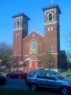
Seven Dolors Catholic Church |
|
000000001995-09-01-0000September 1, 1995
(#95001054) |
Northeast of the junction of Juliette and Pierre Sts.
39°10′39″N 96°33′57″W / 39.1775°N 96.565833°W / 39.1775; -96.565833 (Seven Dolors Catholic Church) |
Manhattan |
|
| 27 |
Strasser House |
|
000000002010-07-06-0000July 6, 2010
(#10000431) |
326 Laramie St.
39°11′05″N 96°33′41″W / 39.184722°N 96.561389°W / 39.184722; -96.561389 (Strasser House) |
Manhattan |
|
| 28 |
Robert Ulrich House |
|
000000001978-09-20-0000September 20, 1978
(#78001287) |
121 N. 8th St.
39°10′49″N 96°34′06″W / 39.180278°N 96.568333°W / 39.180278; -96.568333 (Robert Ulrich House) |
Manhattan |
|
| 29 |
Daniel and Maude Walters House |
Upload image |
000000002012-10-17-0000October 17, 2012
(#12000868) |
100 S. Delaware Ave.
39°10′46″N 96°35′13″W / 39.179312°N 96.586862°W / 39.179312; -96.586862 (Daniel and Maude Walters House) |
Manhattan |
|
| 30 |
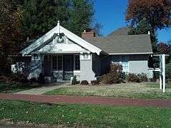
E. A. and Ura Wharton House |
|
000000001995-06-20-0000June 20, 1995
(#95000740) |
608 Houston St.
39°10′50″N 96°33′56″W / 39.180556°N 96.565556°W / 39.180556; -96.565556 (E. A. and Ura Wharton House) |
Manhattan |
|
| 31 |
Woman's Club House |
|
000000001980-11-28-0000November 28, 1980
(#80001472) |
900 Poyntz Ave.
39°10′46″N 96°34′13″W / 39.179444°N 96.570278°W / 39.179444; -96.570278 (Woman's Club House) |
Manhattan |
|
| 32 |
Young Buck Site |
Upload image |
000000002015-01-27-0000January 27, 2015
(#14001211) |
Address Restricted
|
Manhattan vicinity |
|
_County_Courthouse_1.jpg)