| [3] |
Name on the Register[4] |
Image |
Date listed[5] |
Location |
City or town |
Description |
|---|
| 1 |
Archeological Site Number 14MY1 |
Upload image |
000000001982-07-09-0000July 9, 1982
(#82004886) |
Address restricted
|
Little River |
|
| 2 |
Archeological Site Number 14MY365 |
Upload image |
000000001982-07-09-0000July 9, 1982
(#82004885) |
Address restricted
|
Independence |
|
| 3 |
Archeological Site Number 14MY1320 |
Upload image |
000000001982-07-09-0000July 9, 1982
(#82004883) |
Address restricted
|
Independence |
|
| 4 |
Archeological Site Number 14MY1385 |
Upload image |
000000001982-07-09-0000July 9, 1982
(#82004884) |
Address restricted
|
Liberty |
|
| 5 |
Charles M. Ball House |
Upload image |
000000002011-02-07-0000February 7, 2011
(#10001209) |
702 Spruce St.
37°02′14″N 95°37′20″W / 37.037222°N 95.622222°W / 37.037222; -95.622222 (Charles M. Ball House) |
Coffeyville |
|
| 6 |
Bethel African Methodist Episcopal Church |
Upload image |
000000001995-07-28-0000July 28, 1995
(#95000943) |
202 W. 12th St.
37°01′56″N 95°37′02″W / 37.032222°N 95.617222°W / 37.032222; -95.617222 (Bethel African Methodist Episcopal Church) |
Coffeyville |
|
| 7 |
Blakeslee Motor Company Building |
Upload image |
000000001989-08-25-0000August 25, 1989
(#89001145) |
211 W. Myrtle
37°13′32″N 95°42′28″W / 37.225556°N 95.707778°W / 37.225556; -95.707778 (Blakeslee Motor Company Building) |
Independence |
|
| 8 |
Booth Hotel |
Upload image |
000000001983-04-28-0000April 28, 1983
(#83000435) |
201-209 W. Main St.
37°13′22″N 95°42′30″W / 37.222778°N 95.708333°W / 37.222778; -95.708333 (Booth Hotel) |
Independence |
|
| 9 |
Booth Theater |
Upload image |
000000001988-10-13-0000October 13, 1988
(#88001903) |
119 W. Myrtle St.
37°13′31″N 95°42′22″W / 37.225278°N 95.706111°W / 37.225278; -95.706111 (Booth Theater) |
Independence |
|
| 10 |
Brown Barn |
Upload image |
000000002009-04-08-0000April 8, 2009
(#09000191) |
5879 County Road 4300
37°08′19″N 95°40′27″W / 37.138611°N 95.674167°W / 37.138611; -95.674167 (Brown Barn) |
Independence |
Agriculture-Related Resources of Kansas MPS
|
| 11 |
W.P. Brown Mansion |
|
000000001976-12-12-0000December 12, 1976
(#76000833) |
S. Walnut and Eldridge Sts.
37°01′13″N 95°36′50″W / 37.020278°N 95.613889°W / 37.020278; -95.613889 (W.P. Brown Mansion) |
Coffeyville |
|
| 12 |
Cedar Manor Farm |
Upload image |
000000002014-01-08-0000January 8, 2014
(#13001041) |
2326 Cty. Rd. 6400
37°33′36″N 95°55′29″W / 37.559919°N 95.924591°W / 37.559919; -95.924591 (Cedar Manor Farm) |
Fredonia |
Part of the Agriculture-Related Resources of Kansas MPS
|
| 13 |
Cherryvale Carnegie Free Library |
Upload image |
000000001987-08-18-0000August 18, 1987
(#87000961) |
329 E. Main
37°16′01″N 95°32′55″W / 37.266944°N 95.548611°W / 37.266944; -95.548611 (Cherryvale Carnegie Free Library) |
Cherryvale |
|
| 14 |
Coffeyville Carnegie Public Library Building |
Upload image |
000000001987-06-25-0000June 25, 1987
(#87000962) |
415 W. Eighth
37°02′09″N 95°37′23″W / 37.035833°N 95.623056°W / 37.035833; -95.623056 (Coffeyville Carnegie Public Library Building) |
Coffeyville |
|
| 15 |
Condon National Bank |
|
000000001973-01-12-0000January 12, 1973
(#73000771) |
811 Walnut St.
37°02′08″N 95°36′55″W / 37.035556°N 95.615278°W / 37.035556; -95.615278 (Condon National Bank) |
Coffeyville |
|
| 16 |
Cook's Hotel |
Upload image |
000000002006-03-08-0000March 8, 2006
(#06000115) |
113 West Myrtle
37°13′27″N 95°42′24″W / 37.224167°N 95.706667°W / 37.224167; -95.706667 (Cook's Hotel) |
Independence |
|
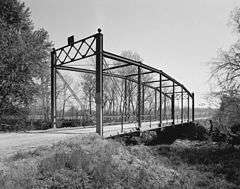
| 17 |
Dewlen-Spohnhauer Bridge |
|
000000001983-03-10-0000March 10, 1983
(#83000436) |
Old U.S. Route 160
37°13′28″N 95°40′43″W / 37.224444°N 95.678611°W / 37.224444; -95.678611 (Dewlen-Spohnhauer Bridge) |
Independence |
|
| 18 |
Eastep Site |
Upload image |
000000002013-01-30-0000January 30, 2013
(#12001240) |
Address restricted
|
Independence |
|
| 19 |
Elk River Archeological District |
Upload image |
000000001978-09-13-0000September 13, 1978
(#78001279) |
Address restricted
|
Elk City |
|
| 20 |
Federal Building-US Post Office |
Upload image |
000000001988-10-19-0000October 19, 1988
(#88002009) |
123 N. 8th
37°13′31″N 95°42′26″W / 37.225278°N 95.707222°W / 37.225278; -95.707222 (Federal Building-US Post Office) |
Independence |
|
| 21 |
First Congregational Church |
Upload image |
000000002014-10-08-0000October 8, 2014
(#14000831) |
400 N. 9th
37°13′36″N 95°42′33″W / 37.2267°N 95.7092°W / 37.2267; -95.7092 (First Congregational Church) |
Independence |
|
| 22 |
Hotel Dale |
Upload image |
000000002008-01-31-0000January 31, 2008
(#07001483) |
206 W. 8th St.
37°02′10″N 95°37′02″W / 37.036111°N 95.617222°W / 37.036111; -95.617222 (Hotel Dale) |
Coffeyville |
|
| 23 |
Independence Bowstring |
Upload image |
000000001990-01-04-0000January 4, 1990
(#89002180) |
Over the Verdigris River, north of junction of Burns and Myrtle Sts.
37°13′29″N 95°41′37″W / 37.224722°N 95.693611°W / 37.224722; -95.693611 (Independence Bowstring) |
Independence |
|
| 24 |
Independence Downtown Historic District |
|
000000002006-07-19-0000July 19, 2006
(#06000624) |
Chestnut, Laurel, Myrtle, Main, Maple between 5th and 9th
37°13′30″N 95°42′18″W / 37.225°N 95.705°W / 37.225; -95.705 (Independence Downtown Historic District) |
Independence |
|
| 25 |
Independence Junior High School |
Upload image |
000000002009-12-30-0000December 30, 2009
(#09001165) |
300 W. Locust St.
37°13′40″N 95°42′34″W / 37.227714°N 95.709378°W / 37.227714; -95.709378 (Independence Junior High School) |
Independence |
|
| 26 |
Independence Public Carnegie Library |
|
000000001988-01-11-0000January 11, 1988
(#87002231) |
220 E. Maple
37°13′25″N 95°42′12″W / 37.223611°N 95.703333°W / 37.223611; -95.703333 (Independence Public Carnegie Library) |
Independence |
|
| 27 |
Infinity Archeological Site |
Upload image |
000000001971-03-24-0000March 24, 1971
(#71000320) |
Southwest of the confluence of the Elk River and Card Creek[6]
37°15′09″N 95°51′20″W / 37.252500°N 95.855556°W / 37.252500; -95.855556 (Infinity Archeological Site) |
Independence |
|
| 28 |
Memorial Hall |
Upload image |
000000002005-06-10-0000June 10, 2005
(#05000554) |
Junction of Pennsylvania Ave. and E. Locust St.
37°13′45″N 95°42′23″W / 37.229167°N 95.706389°W / 37.229167; -95.706389 (Memorial Hall) |
Independence |
|
| 29 |
Midland Theater |
|
000000002005-02-09-0000February 9, 2005
(#05000007) |
212-214 W. 8th St.
37°02′17″N 95°36′58″W / 37.038056°N 95.616111°W / 37.038056; -95.616111 (Midland Theater) |
Coffeyville |
|
| 30 |
Onion Creek Bridge |
|
000000001990-01-04-0000January 4, 1990
(#89002172) |
Over Onion Creek, south of Coffeyville
37°01′33″N 95°39′23″W / 37.025833°N 95.656389°W / 37.025833; -95.656389 (Onion Creek Bridge) |
Coffeyville |
|
| 31 |
Pennsylvania Avenue Rock Creek Bridge |
Upload image |
000000001985-07-02-0000July 2, 1985
(#85001437) |
Pennsylvania Ave. over Rock Creek
37°12′51″N 95°42′24″W / 37.214167°N 95.706667°W / 37.214167; -95.706667 (Pennsylvania Avenue Rock Creek Bridge) |
Independence |
|
| 32 |
Terminal Building |
Upload image |
000000001982-06-14-0000June 14, 1982
(#82002666) |
717 Walnut
37°02′11″N 95°36′54″W / 37.036389°N 95.615°W / 37.036389; -95.615 (Terminal Building) |
Coffeyville |
|
| 33 |
Union Implement and Hardware Building-Masonic Temple |
Upload image |
000000001988-10-13-0000October 13, 1988
(#88002008) |
121-123 W. Main
37°13′23″N 95°42′27″W / 37.223056°N 95.7075°W / 37.223056; -95.7075 (Union Implement and Hardware Building-Masonic Temple) |
Independence |
|
| 34 |
Washington School |
Upload image |
000000002015-04-14-0000April 14, 2015
(#15000147) |
300 E. Myrtle St.
37°13′28″N 95°42′12″W / 37.2244°N 95.7034°W / 37.2244; -95.7034 (Washington School) |
Independence |
|
.jpg)