| [3] |
Name on the Register[4] |
Image |
Date listed[5] |
Location |
City or town |
Description |
|---|
| 1 |
Augusta Theater |
Upload image |
000000001990-10-31-0000October 31, 1990
(#90001577) |
525 State St.
37°40′37″N 96°59′22″W / 37.676944°N 96.989444°W / 37.676944; -96.989444 (Augusta Theater) |
Augusta |
|
| 2 |
Beaumont Hotel |
Upload image |
000000002012-02-03-0000February 3, 2012
(#11001078) |
11651 SE Main St.
37°39′21″N 96°31′59″W / 37.655903°N 96.532928°W / 37.655903; -96.532928 (Beaumont Hotel) |
Beaumont |
|
| 3 |
Beaumont St. Louis and San Francisco Railroad Retention Pond |
Upload image |
000000002011-10-06-0000October 6, 2011
(#11000724) |
SE 116th St. & SE Beaumont Rd.
37°39′19″N 96°32′06″W / 37.655278°N 96.535°W / 37.655278; -96.535 (Beaumont St. Louis and San Francisco Railroad Retention Pond) |
Beaumont |
|
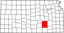
| 4 |
Beaumont St. Louis and San Francisco Railroad Water Tank |
|
000000001993-08-19-0000August 19, 1993
(#93000843) |
Junction of 3rd and D Sts.
37°39′18″N 96°31′51″W / 37.655°N 96.530833°W / 37.655; -96.530833 (Beaumont St. Louis and San Francisco Railroad Water Tank) |
Beaumont |
|
| 5 |
Butler County Courthouse |
|
000000002002-04-26-0000April 26, 2002
(#02000390) |
205 W. Central Ave.
37°49′01″N 96°51′06″W / 37.816944°N 96.851667°W / 37.816944; -96.851667 (Butler County Courthouse) |
El Dorado |
|
| 6 |
Creed-Mills House |
Upload image |
000000002013-06-25-0000June 25, 2013
(#13000430) |
219 North Maple Street
37°31′17″N 97°01′05″W / 37.52141°N 97.01804°W / 37.52141; -97.01804 (Creed-Mills House) |
Douglass |
|
| 7 |
Douglass Township Community Building |
Upload image |
000000001995-04-27-0000April 27, 1995
(#95000512) |
206 S. Forest
37°31′05″N 97°00′56″W / 37.518056°N 97.015556°W / 37.518056; -97.015556 (Douglass Township Community Building) |
Douglass |
|
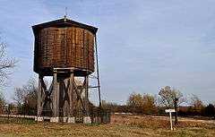
| 8 |
El Dorado Carnegie Library |
|
000000001987-06-25-0000June 25, 1987
(#87000931) |
101 S. Star
37°49′00″N 96°51′17″W / 37.816667°N 96.854722°W / 37.816667; -96.854722 (El Dorado Carnegie Library) |
El Dorado |
|
| 9 |
El Dorado Historic District |
|
000000002013-10-30-0000October 30, 2013
(#13000855) |
Roughly 1 blk. E. & W. of N. & S. Main Sts. from E. 3rd to E. Locust Aves.
37°49′02″N 96°50′59″W / 37.817353°N 96.849806°W / 37.817353; -96.849806 (El Dorado Historic District) |
El Dorado |
|
| 10 |
El Dorado Missouri Pacific Depot |
Upload image |
000000001994-05-06-0000May 6, 1994
(#94000429) |
430 N. Main St.
37°49′18″N 96°50′57″W / 37.821667°N 96.849167°W / 37.821667; -96.849167 (El Dorado Missouri Pacific Depot) |
El Dorado |
|
| 11 |
First Presbyterian Church of De Graff |
Upload image |
000000002014-06-27-0000June 27, 2014
(#14000346) |
1145 NW. 108th St, Burns, KS (mailing address)
37°58′51″N 96°51′44″W / 37.9807°N 96.8621°W / 37.9807; -96.8621 (First Presbyterian Church of De Graff) |
De Graff |
|
| 12 |
Amos H. Gish Building |
Upload image |
000000002012-07-03-0000July 3, 2012
(#12000383) |
317 S. Main
37°48′54″N 96°51′01″W / 37.81492°N 96.850203°W / 37.81492; -96.850203 (Amos H. Gish Building) |
El Dorado |
|
| 13 |
C. N. James Cabin |
Upload image |
000000001973-04-13-0000April 13, 1973
(#73000745) |
305 State St.
37°39′53″N 96°58′46″W / 37.664722°N 96.979444°W / 37.664722; -96.979444 (C. N. James Cabin) |
Augusta |
|
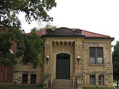
| 14 |
Little Walnut River Pratt Truss Bridge |
|
000000002003-05-09-0000May 9, 2003
(#03000377) |
SW. 160th Rd., ½ mile west of its intersection with Purity Springs Rd.
37°35′46″N 96°55′24″W / 37.596111°N 96.923333°W / 37.596111; -96.923333 (Little Walnut River Pratt Truss Bridge) |
Bois D'Arc |
|
| 15 |
Loomis-Parry Residence |
Upload image |
000000002009-07-08-0000July 8, 2009
(#09000495) |
1003 State St.
37°40′56″N 96°58′44″W / 37.682333°N 96.978986°W / 37.682333; -96.978986 (Loomis-Parry Residence) |
Augusta |
|
| 16 |
John Moyle Building |
Upload image |
000000002014-06-27-0000June 27, 2014
(#14000347) |
605 & 607 N. State St.
37°40′40″N 96°58′45″W / 37.6778°N 96.9792°W / 37.6778; -96.9792 (John Moyle Building) |
Augusta |
|
| 17 |
Muddy Creek Bridge |
Upload image |
000000001985-07-02-0000July 2, 1985
(#85001425) |
Off U.S. Route 77
37°32′03″N 96°57′04″W / 37.534167°N 96.951111°W / 37.534167; -96.951111 (Muddy Creek Bridge) |
Douglass |
|
| 18 |
Oak Lawn Farm Dairy Barn |
Upload image |
000000002005-11-05-0000November 5, 2005
(#05001202) |
12464 NW. Meadowlark
38°00′24″N 97°05′46″W / 38.006667°N 97.096111°W / 38.006667; -97.096111 (Oak Lawn Farm Dairy Barn) |
Whitewater |
|
| 19 |
James T. Oldham House |
Upload image |
000000002006-11-21-0000November 21, 2006
(#06001054) |
321 S. Denver St.
37°48′53″N 96°51′23″W / 37.814722°N 96.856389°W / 37.814722; -96.856389 (James T. Oldham House) |
El Dorado |
|
| 20 |
Polecat Creek Bridge |
|
000000001985-07-02-0000July 2, 1985
(#85001438) |
5 miles west and 2 miles south of Douglass
37°29′23″N 97°06′33″W / 37.489722°N 97.109167°W / 37.489722; -97.109167 (Polecat Creek Bridge) |
Douglass |
|
| 21 |
Ray L. Smith House |
Upload image |
000000002015-01-07-0000January 7, 2015
(#14001117) |
812 W. Central Ave.
37°49′03″N 96°51′37″W / 37.8175°N 96.8603°W / 37.8175; -96.8603 (Ray L. Smith House) |
El Dorado |
|
| 22 |
Towanda Masonic Lodge No. 30 A.F. and A.M. |
Upload image |
000000002004-01-14-0000January 14, 2004
(#03001392) |
401 Main St.
37°47′44″N 97°00′09″W / 37.795556°N 97.0025°W / 37.795556; -97.0025 (Towanda Masonic Lodge No. 30 A.F. and A.M.) |
Towanda |
|
| 23 |
US Post Office-Augusta |
Upload image |
000000001989-10-17-0000October 17, 1989
(#89001632) |
119 E. 5th St.
37°40′33″N 96°58′38″W / 37.675833°N 96.977222°W / 37.675833; -96.977222 (US Post Office-Augusta) |
Augusta |
|
| 24 |
Viets Block |
Upload image |
000000002012-04-16-0000April 16, 2012
(#12000202) |
427, 429, & 431 State St.
37°40′34″N 96°58′46″W / 37.676025°N 96.979326°W / 37.676025; -96.979326 (Viets Block) |
Augusta |
|
| 25 |
Whitewater Falls Stock Farm |
Upload image |
000000002014-10-08-0000October 8, 2014
(#14000828) |
433 Falls Rd.
37°49′53″N 97°02′20″W / 37.8313°N 97.0388°W / 37.8313; -97.0388 (Whitewater Falls Stock Farm) |
Towanda |
|
| 26 |
Yingling Brothers Auto Company |
Upload image |
000000002011-07-05-0000July 5, 2011
(#11000409) |
411 S. Main St.
37°48′51″N 96°51′01″W / 37.814167°N 96.850278°W / 37.814167; -96.850278 (Yingling Brothers Auto Company) |
El Dorado |
Roadside Kansas MPS |