| [3] |
Name on the Register[4] |
Image |
Date listed[5] |
Location |
City or town |
Description |
|---|
| 1 |
Albert Albers Barn |
Upload image |
000000001987-05-07-0000May 7, 1987
(#86003552) |
South of Bendena
39°41′13″N 95°10′52″W / 39.686944°N 95.181111°W / 39.686944; -95.181111 (Albert Albers Barn) |
Bendena |
|
| 2 |
Nicholas Bohr Barn |
Upload image |
000000001987-05-07-0000May 7, 1987
(#86003531) |
Southeast of Troy
39°43′35″N 95°02′49″W / 39.726389°N 95.046944°W / 39.726389; -95.046944 (Nicholas Bohr Barn) |
Troy |
|
| 3 |
Brenner Vineyards Historic District |
Upload image |
000000002005-05-24-0000May 24, 2005
(#04001514) |
Southwest of the junction of Mineral Point and 95th Rds.
39°38′26″N 95°05′09″W / 39.640556°N 95.085833°W / 39.640556; -95.085833 (Brenner Vineyards Historic District) |
Doniphan |
|
| 4 |
Herman Chrystal Barn |
Upload image |
000000001987-05-07-0000May 7, 1987
(#86003538) |
West of Wathena
39°44′14″N 95°00′45″W / 39.737222°N 95.0125°W / 39.737222; -95.0125 (Herman Chrystal Barn) |
Wathena |
|
| 5 |
Doniphan Archeological Site |
Upload image |
000000001974-03-01-0000March 1, 1974
(#74000825) |
Address restricted
|
Doniphan |
|
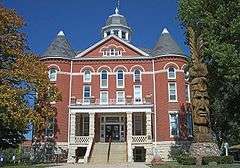
| 6 |
Doniphan County Courthouse |
|
000000001974-07-15-0000July 15, 1974
(#74000826) |
Courthouse Sq., bounded by Walnut, Liberty, Chestnut, and Main Sts.
39°47′10″N 95°05′20″W / 39.786111°N 95.088889°W / 39.786111; -95.088889 (Doniphan County Courthouse) |
Troy |
|
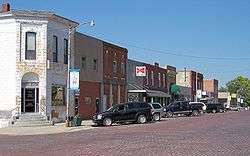
| 7 |
Doniphan County Courthouse Square Historic District |
|
000000002002-07-03-0000July 3, 2002
(#02000717) |
Roughly bounded by E. Walnut, E. Chestnut, S. Main, and S. Liberty Sts.
39°47′10″N 95°05′21″W / 39.786111°N 95.089167°W / 39.786111; -95.089167 (Doniphan County Courthouse Square Historic District) |
Troy |
|
| 8 |
Doniphan County Waddell Truss Bridge |
Upload image |
000000001990-01-04-0000January 4, 1990
(#89002185) |
Troy City Park, W. Myrtle St.
39°47′17″N 95°05′41″W / 39.788056°N 95.094722°W / 39.788056; -95.094722 (Doniphan County Waddell Truss Bridge) |
Troy |
|
| 9 |
Mathew Eylar Barn No. 1 |
Upload image |
000000001987-05-07-0000May 7, 1987
(#86003549) |
South of Denton off K-20
39°39′15″N 95°15′47″W / 39.654167°N 95.263056°W / 39.654167; -95.263056 (Mathew Eylar Barn No. 1) |
Denton |
|
| 10 |
Mathew Eylar Barn No. 2 |
Upload image |
000000001987-05-07-0000May 7, 1987
(#86003550) |
Southeast of Denton off K-20
39°39′47″N 95°14′30″W / 39.663056°N 95.241667°W / 39.663056; -95.241667 (Mathew Eylar Barn No. 2) |
Denton |
|
| 11 |
Fanning Archeological Site |
Upload image |
000000001972-06-20-0000June 20, 1972
(#72000492) |
Address restricted
|
Fanning |
|
| 12 |
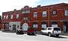
First National Bank Building |
Upload image |
000000002008-07-02-0000July 2, 2008
(#08000609) |
422-424 W. Main St.
39°51′35″N 95°16′08″W / 39.859722°N 95.268889°W / 39.859722; -95.268889 (First National Bank Building) |
Highland |
|
| 13 |
John R. Hale Barn |
Upload image |
000000001987-05-07-0000May 7, 1987
(#86003545) |
K-120
39°48′32″N 95°15′57″W / 39.808889°N 95.265833°W / 39.808889; -95.265833 (John R. Hale Barn) |
Highland |
|
| 14 |
George Hanson Barn |
Upload image |
000000001987-05-07-0000May 7, 1987
(#86003548) |
South of Leona
39°45′58″N 95°19′15″W / 39.766111°N 95.320833°W / 39.766111; -95.320833 (George Hanson Barn) |
Leona |
|
| 15 |
Highland Christian Church |
Upload image |
000000002007-04-04-0000April 4, 2007
(#07000250) |
102 E. Main St.
39°51′35″N 95°15′53″W / 39.859722°N 95.264722°W / 39.859722; -95.264722 (Highland Christian Church) |
Highland |
|
| 16 |
Highland Presbyterian Church |
Upload image |
000000002007-04-04-0000April 4, 2007
(#07000248) |
101 South Ave.
39°51′34″N 95°16′15″W / 39.859444°N 95.270833°W / 39.859444; -95.270833 (Highland Presbyterian Church) |
Highland |
|
| 17 |
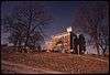
Iowa, Sac, and Fox Presbyterian Mission |
Upload image |
000000001970-12-02-0000December 2, 1970
(#70000248) |
1.5 miles east of Highland on U.S. Route 36 and 0.2 miles north on K-136
39°51′51″N 95°13′45″W / 39.864167°N 95.229167°W / 39.864167; -95.229167 (Iowa, Sac, and Fox Presbyterian Mission) |
Highland |
|
| 18 |
Irvin Hall, Highland Community Junior College |
|
000000001971-02-24-0000February 24, 1971
(#71000307) |
Highland Community College campus
39°51′36″N 95°16′13″W / 39.86°N 95.270278°W / 39.86; -95.270278 (Irvin Hall, Highland Community Junior College) |
Highland |
|
| 19 |
Fred W. Kienhoff Barn |
Upload image |
000000001987-05-07-0000May 7, 1987
(#86003537) |
West of Wathena
39°43′34″N 95°02′21″W / 39.726111°N 95.039167°W / 39.726111; -95.039167 (Fred W. Kienhoff Barn) |
Wathena |
|
| 20 |
George Kinkhead Barn |
|
000000001987-05-07-0000May 7, 1987
(#86003542) |
Off U.S. Route 36
39°47′31″N 95°05′05″W / 39.791944°N 95.084722°W / 39.791944; -95.084722 (George Kinkhead Barn) |
Troy |
|
| 21 |
Lincoln School, District 2 |
Upload image |
000000002014-06-27-0000June 27, 2014
(#14000348) |
410 N. 9th St.
39°45′31″N 94°52′51″W / 39.7585°N 94.8807°W / 39.7585; -94.8807 (Lincoln School, District 2) |
Elwood |
|
| 22 |
Abram M. Minier House |
Upload image |
000000002014-04-07-0000April 7, 2014
(#14000115) |
307 South Ave.
39°51′28″N 95°16′15″W / 39.857734°N 95.27097°W / 39.857734; -95.27097 (Abram M. Minier House) |
Highland |
Part of the Highland, Doniphan County, Kansas MPS
|
| 23 |
Godfrey Nuzum Barn |
Upload image |
000000001987-05-07-0000May 7, 1987
(#86003533) |
K-7
39°53′31″N 95°12′38″W / 39.891944°N 95.210556°W / 39.891944; -95.210556 (Godfrey Nuzum Barn) |
Sparks |
|
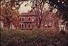
| 24 |
Poulet House |
|
000000001971-09-03-0000September 3, 1971
(#71000308) |
Poplar St. between 1st and 2nd Sts.
39°59′00″N 95°17′49″W / 39.983333°N 95.296944°W / 39.983333; -95.296944 (Poulet House) |
White Cloud |
|
| 25 |
St. Benedict's Church |
Upload image |
000000001998-04-09-0000April 9, 1998
(#98000324) |
5 miles southwest of Bendena
39°43′08″N 95°13′52″W / 39.718889°N 95.231111°W / 39.718889; -95.231111 (St. Benedict's Church) |
Bendena |
|
| 26 |
St. Martha's AME Church and Parsonage |
Upload image |
000000002000-07-20-0000July 20, 2000
(#00000757) |
101 S. Canada
39°51′33″N 95°15′41″W / 39.859167°N 95.261389°W / 39.859167; -95.261389 (St. Martha's AME Church and Parsonage) |
Highland |
|
| 27 |
St. Mary's Catholic Church |
Upload image |
000000002001-04-25-0000April 25, 2001
(#01000413) |
446 K-137
39°40′54″N 95°19′49″W / 39.681667°N 95.330278°W / 39.681667; -95.330278 (St. Mary's Catholic Church) |
Purcell |
|
| 28 |
John Silvers Barn |
Upload image |
000000001987-05-07-0000May 7, 1987
(#86003553) |
North of Wathena
39°49′56″N 94°57′33″W / 39.832222°N 94.959167°W / 39.832222; -94.959167 (John Silvers Barn) |
Wathena |
|
| 29 |
Site No. RH00-062 |
|
000000001987-06-19-0000June 19, 1987
(#87001001) |
6½ miles southeast of Rulo, Nebraska and 200 feet west of the road between White Cloud, Kansas and Rulo
40°00′00″N 95°19′55″W / 40.0°N 95.331944°W / 40.0; -95.331944 (Site No. RH00-062) |
Iowa Township |
Extends into Brown County, Kansas and Richardson County, Nebraska
|
| 30 |
John Streib Barn |
Upload image |
000000001987-05-07-0000May 7, 1987
(#86003547) |
North of Leona
39°47′38″N 95°19′13″W / 39.793889°N 95.320278°W / 39.793889; -95.320278 (John Streib Barn) |
Leona |
|
| 31 |
J.A. Symns Barn |
Upload image |
000000001987-05-07-0000May 7, 1987
(#86003536) |
K-7
39°40′35″N 95°08′30″W / 39.676389°N 95.141667°W / 39.676389; -95.141667 (J.A. Symns Barn) |
Bendena |
|
| 32 |
Wathena Fruit Growers' Association Building |
|
000000002009-12-17-0000December 17, 2009
(#09001092) |
104 3rd St.
39°45′34″N 94°56′52″W / 39.759578°N 94.947656°W / 39.759578; -94.947656 (Wathena Fruit Growers' Association Building) |
Wathena |
|
| 33 |
T.L. White Barn |
Upload image |
000000001987-05-07-0000May 7, 1987
(#86003544) |
K-7
39°40′31″N 95°08′39″W / 39.675278°N 95.144167°W / 39.675278; -95.144167 (T.L. White Barn) |
Bendena |
|
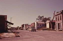
| 34 |
White Cloud Historic District |
|
000000001996-06-28-0000June 28, 1996
(#96000701) |
Roughly bounded by Poplar, 6th, and Chesnut Sts. and K-7
39°58′34″N 95°17′49″W / 39.976111°N 95.296944°W / 39.976111; -95.296944 (White Cloud Historic District) |
White Cloud |
|
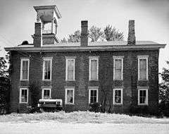
| 35 |
White Cloud School |
|
000000001973-04-13-0000April 13, 1973
(#73000752) |
Southwestern corner of 5th and Main Sts.
39°58′49″N 95°18′00″W / 39.980278°N 95.3°W / 39.980278; -95.3 (White Cloud School) |
White Cloud |
|
| 36 |
M. D. L. Williams Barn |
Upload image |
000000001987-05-07-0000May 7, 1987
(#86003551) |
3 miles south of K-20
39°40′59″N 95°12′27″W / 39.683056°N 95.2075°W / 39.683056; -95.2075 (M. D. L. Williams Barn) |
Bendena |
|
| 37 |
A.L. Wynkoop House |
Upload image |
000000002007-04-04-0000April 4, 2007
(#07000251) |
307 W. Pennsylvania
39°51′27″N 95°16′05″W / 39.8575°N 95.268056°W / 39.8575; -95.268056 (A.L. Wynkoop House) |
Highland |
|