National Register of Historic Places listings in Placer County, California
Location of Placer County in California
This is a list of the National Register of Historic Places listings in Placer County, California.
This is intended to be a complete list of the properties and districts on the National Register of Historic Places in Placer County, California, United States. Latitude and longitude coordinates are provided for many National Register properties and districts; these locations may be seen together in a Google map.[1]
There are 33 properties and districts listed on the National Register in the county.
- This National Park Service list is complete through NPS recent listings posted December 16, 2016.[2]
Current listings
| [3] | Name on the Register[4] | Image | Date listed[5] | Location | City or town | Description |
|---|---|---|---|---|---|---|
| 1 | Auburn City Hall and Fire House |  |
(#11000935) |
1103 High St. 38°53′54″N 121°04′13″W / 38.898228°N 121.070367°W |
Auburn | |
| 2 | Auburn Fire House No. 1 | 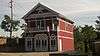 |
(#11000936) |
El Dorado St. & Lincoln Way 38°54′14″N 121°03′59″W / 38.903808°N 121.066458°W |
Auburn | |
| 3 | Auburn Fire House No. 2 | 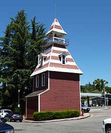 |
(#11000937) |
Corner of Washington, Main, & Commercial Sts. 38°53′45″N 121°04′50″W / 38.895947°N 121.080442°W |
Auburn | |
| 4 | Auburn Grammar School | 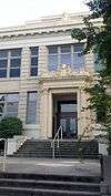 |
(#11000938) |
1225 Lincoln Way 38°53′52″N 121°04′30″W / 38.897897°N 121.074897°W |
Auburn | |
| 5 | Auburn Masonic Temple | 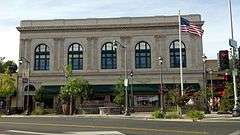 |
(#11000939) |
948 Lincoln Way 38°53′56″N 121°04′15″W / 38.898953°N 121.070856°W |
Auburn | |
| 6 | Auburn Public Library |  |
(#11000153) |
175 Almond St. 38°53′59″N 121°04′19″W / 38.899722°N 121.071944°W |
Auburn | |
| 7 | Irene Burns House | 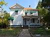 |
(#13000141) |
405 Linden Ave. 38°53′55″N 121°04′00″W / 38.898548°N 121.066761°W |
Auburn | |
| 8 | California Granite Company | 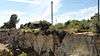 |
(#12000375) |
5255 Pacific St. 38°47′21″N 121°14′08″W / 38.789207°N 121.235602°W |
Rocklin | |
| 9 | Carnegie Library | 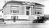 |
(#09000199) |
557 Lincoln St. 38°45′13″N 121°17′07″W / 38.753722°N 121.285278°W |
Roseville | |
| 10 | Chapel of the Transfiguration | Upload image | (#11000534) |
855 W. Lake Blvd. 39°09′12″N 120°08′50″W / 39.153333°N 120.147222°W |
Tahoe City | |
| 11 | Colfax Freight Depot |  |
(#99001564) |
7 Main St. 39°06′02″N 120°56′34″W / 39.100556°N 120.942778°W |
Colfax | |
| 12 | Colfax Passenger Depot |  |
(#98001605) |
Main St. and Railroad Ave. 39°05′58″N 120°57′08″W / 39.099444°N 120.952222°W |
Colfax | |
| 13 | DeWitt General Hospital | Upload image | (#16000003) |
1st St. & Bell Ave. 38°56′31″N 121°06′14″W / 38.941890°N 121.103830°W |
Auburn | |
| 14 | Dutch Flat Historic District |  |
(#73000419) |
Main and Stockton Sts. 39°12′17″N 120°50′05″W / 39.204722°N 120.834722°W |
Dutch Flat | |
| 15 | El Toyon |  |
(#10000118) |
211 Brook Rd. 38°53′46″N 121°03′41″W / 38.895975°N 121.061461°W |
Auburn | |
| 16 | Fiddyment Ranch Main Complex | %2C_main_building.jpg) |
(#10000503) |
4440 Phillip Rd. 38°47′07″N 121°22′38″W / 38.785278°N 121.377222°W |
Roseville | |
| 17 | Griffith House | %2C_facade.jpg) |
(#78000733) |
7325 English Colony Way 38°51′08″N 121°09′55″W / 38.852222°N 121.165278°W |
Penryn | |
| 18 | Griffith Quarry |  |
(#77000322) |
Taylor Rd. 38°50′58″N 121°09′44″W / 38.849444°N 121.162222°W |
Penryn | |
| 19 | Haman House | .jpg) |
(#76000507) |
424 Oak St. 38°44′49″N 121°17′04″W / 38.746944°N 121.284444°W |
Roseville | |
| 20 | Lake Tahoe Dam | 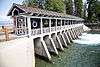 |
(#81000713) |
SR 89 at Truckee River 39°10′01″N 120°08′38″W / 39.166944°N 120.143889°W |
Tahoe City | |
| 21 | Lincoln Public Library | _Public_Library.jpg) |
(#90001814) |
590 Fifth St. 38°53′29″N 121°17′26″W / 38.891389°N 121.290556°W |
Lincoln | |
| 22 | Michigan Bluff-Last Chance Trail | Upload image | (#92000854) |
From Michigan Bluff NE to Last Chance 39°04′38″N 120°40′59″W / 39.077222°N 120.683056°W |
Michigan Bluff | |
| 23 | Mountain Quarries Bridge | 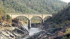 |
(#04000014) |
North Fork of the American River 38°54′46″N 121°02′30″W / 38.912792°N 121.041581°W |
Auburn | |
| 24 | Newcastle Portuguese Hall | _Portuguese_Hall%2C_facade.jpg) |
(#82002225) |
Taylor Rd. 38°52′25″N 121°08′24″W / 38.873611°N 121.14°W |
Newcastle | |
| 25 | Oddfellows Hall |  |
(#11000940) |
1256 Lincoln Way 38°53′52″N 121°04′30″W / 38.897847°N 121.074972°W |
Auburn | Three-story red brick Italianate home of IOOF Lodge No. 7, founded in 1852. Henry T. Holmes, builder of the Hall, was a '49er and a founding father of Auburn.[6] |
| 26 | Old Auburn Historic District | 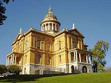 |
(#70000138) |
Roughly bounded by Maple, Commercial, Court, Washington, Spring, and Sacramento Sts. 38°53′39″N 121°04′34″W / 38.894167°N 121.076111°W |
Auburn | |
| 27 | Outlet Gates and Gatekeeper's Cabin |  |
(#72000245) |
U.S. 89 at mouth of Truckee River 39°10′00″N 120°08′33″W / 39.166667°N 120.1425°W |
Tahoe City | |
| 28 | Placer County Bank | 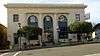 |
(#11000941) |
874 Lincoln Way 38°54′01″N 121°04′09″W / 38.900356°N 121.069125°W |
Auburn | |
| 29 | Stevens Trail | Upload image | (#02001391) |
Roughly bounded Iowa Hill, canyon of North fork Of American R., until at Secret Ravine, top of ridge of Colfax 39°06′52″N 120°54′17″W / 39.114444°N 120.904722°W |
Colfax | |
| 30 | Strap Ravine Nisenan Maidu Indian Site |  |
(#73000420) |
1970 Johnson Ranch Dr.[7] Coordinates missing |
Roseville | |
| 31 | Summit Soda Springs | Upload image | (#78000734) |
Southeast of Soda Springs 39°14′48″N 120°19′30″W / 39.246667°N 120.325°W |
Soda Springs | |
| 32 | Watson Log Cabin | 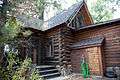 |
(#79000518) |
560 N. Lake Blvd 39°10′17″N 120°08′20″W / 39.171389°N 120.138889°W |
Tahoe City | |
| 33 | Woman's Club of Lincoln | %2C_entrance.jpg) |
(#01000331) |
499 E St. 38°53′29″N 121°17′19″W / 38.891389°N 121.288611°W |
Lincoln |
See also
| Wikimedia Commons has media related to National Register of Historic Places in Placer County, California. |
- List of National Historic Landmarks in California
- National Register of Historic Places listings in California
- California Historical Landmarks in Placer County, California
References
- ↑ The latitude and longitude information provided in this table was derived originally from the National Register Information System, which has been found to be fairly accurate for about 99% of listings. For about 1% of NRIS original coordinates, experience has shown that one or both coordinates are typos or otherwise extremely far off; some corrections may have been made. A more subtle problem causes many locations to be off by up to 150 yards, depending on location in the country: most NRIS coordinates were derived from tracing out latitude and longitudes off of USGS topographical quadrant maps created under the North American Datum of 1927, which differs from the current, highly accurate WGS84 GPS system used by most on-line maps. Chicago is about right, but NRIS longitudes in Washington are higher by about 4.5 seconds, and are lower by about 2.0 seconds in Maine. Latitudes differ by about 1.0 second in Florida. Some locations in this table may have been corrected to current GPS standards.
- ↑ "National Register of Historic Places: Weekly List Actions". National Park Service, United States Department of the Interior. Retrieved on December 16, 2016.
- ↑ Numbers represent an ordering by significant words. Various colorings, defined here, differentiate National Historic Landmarks and historic districts from other NRHP buildings, structures, sites or objects.
- ↑ National Park Service (2010-07-09). "National Register Information System". National Register of Historic Places. National Park Service.
- ↑ The eight-digit number below each date is the number assigned to each location in the National Register Information System database, which can be viewed by clicking the number.
- ↑ Carmel Barry-Schweyer (May 5, 2011). "National Register of Historic Places Registration: Oddfellows Hall / International Order of Oddfellows Hall / IOOF Hall" (PDF). Retrieved October 6, 2016.
- ↑ "Recreation Guide: Fall 2016". City of Roseville. 2016-08-09. Retrieved 2016-08-08.
| Topics | |
|---|---|
| Lists by states |
|
| Lists by insular areas | |
| Lists by associated states | |
| Other areas | |
| |
This article is issued from Wikipedia - version of the 10/6/2016. The text is available under the Creative Commons Attribution/Share Alike but additional terms may apply for the media files.