Northern Province, Sri Lanka
| Northern Province வட மாகாணம் උතුරු පළාත | |||
|---|---|---|---|
| Province | |||
|
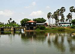
Sunset over a lagoon | |||
| |||
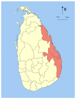
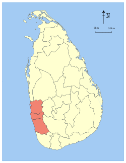
 Location within Sri Lanka | |||
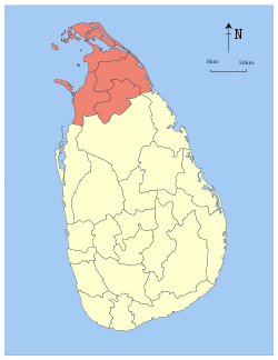
 Districts of the Northern Province | |||
| Coordinates: 09°12′N 80°25′E / 9.200°N 80.417°ECoordinates: 09°12′N 80°25′E / 9.200°N 80.417°E | |||
| Country | Sri Lanka | ||
| Created | 1 October 1833 | ||
| Provincial council | 14 November 1987 | ||
| Capital | Jaffna | ||
| Largest City | Vavuniya | ||
| Districts | |||
| Government | |||
| • Type | Provincial council | ||
| • Body | Northern Provincial Council | ||
| • Governor | Reginald Cooray | ||
| • Chief Minister | C. V. Vigneswaran | ||
| • MPs | |||
| Area[1] | |||
| • Total | 8,884 km2 (3,430 sq mi) | ||
| • Land | 8,290 km2 (3,200 sq mi) | ||
| Area rank | 3rd (13.54% of total area) | ||
| Population (2012 census)[2] | |||
| • Total | 1,058,762 | ||
| • Rank | 9th (5.22% of total pop.) | ||
| • Density | 120/km2 (310/sq mi) | ||
| Ethnicity(2012 census)[2] | |||
| • Sri Lankan Tamil | 987,692 (93.29%) | ||
| • Sri Lankan Moors | 32,364 (3.06%) | ||
| • Sinhalese | 32,331 (3.05%) | ||
| • Indian Tamil | 6,049 (0.57%) | ||
| • Other | 326 (0.03%) | ||
| Religion(2012 census)[3] | |||
| • Hindu | 789,362 (74.56%) | ||
| • Christian | 204,005 (19.27%) | ||
| • Muslim | 34,040 (3.22%) | ||
| • Buddhist | 30,387 (2.87%) | ||
| • Other | 968 (0.09%) | ||
| Time zone | Sri Lanka (UTC+05:30) | ||
| Post Codes | 40000-45999 | ||
| Telephone Codes | 021, 023, 024 | ||
| ISO 3166 code | LK-4 | ||
| Vehicle registration | NP | ||
| Official Languages | Tamil, Sinhalese | ||
| Flower | Kaanthal | ||
| Tree | Maruthu | ||
| Bird | Seven sisters | ||
| Animal | Male deer | ||
| Website |
www | ||

The Northern Province (Tamil: வட மாகாணம் Vaṭa Mākāṇam; Sinhalese: උතුරු පළාත Uturu Paḷāta) is one of the nine provinces of Sri Lanka, the first level administrative division of the country. The provinces have existed since the 19th century but did not have any legal status until 1987 when the 13th Amendment to the Constitution of Sri Lanka established provincial councils.[4][5] Between 1988 and 2006 the province was temporarily merged with the Eastern Province to form the North Eastern Province. The capital of the province is Jaffna. The majority of the Sri Lankan Civil War was played out and had its roots in this province.
History

Parts of present-day Northern Province were part of the pre-colonial Jaffna kingdom.[6] Other parts were ruled by Vanniar Chieftains who paid tribute to the Jaffna kingdom. The province then came under Portuguese, Dutch and British control. In 1815 the British gained control of the entire island of Ceylon. They divided the island into three ethnic based administrative structures: Low Country Sinhalese, Kandyan Sinhalese and Tamil. The Northern Province was part of the Tamil administration. In 1833, in accordance with the recommendations of the Colebrooke-Cameron Commission, the ethnic based administrative structures were unified into a single administration divided into five geographic provinces.[7] The districts of Jaffna, Mannar, Nuvarakalaviya (present day Anuradhapura District) and Vanni formed the new Northern Province.[8] Nuvarakalaviya was transferred to the newly created North Central Province in 1873.[9]
The Indo-Lanka Accord signed on 29 July 1987 required the Sri Lankan government to devolve powers to the provinces and, in the interim, to merge the Northern and Eastern provinces into one administrative unit. The accord required a referendum to be held by 31 December 1988 in the Eastern Province to decide whether the merger should be permanent. Crucially, the accord allowed the Sri Lankan president to postpone the referendum at his discretion.[10]
On 14 November 1987 the Sri Lankan Parliament passed the 13th Amendment to the 1978 Constitution of Sri Lanka and the Provincial Councils Act No 42 of 1987, establishing provincial councils.[5][11] On September 2 and 8 1988 President Jayewardene issued proclamations enabling the Northern and Eastern provinces to be one administrative unit administered by one elected Council.[12] The North-East Province was born.
The proclamations were only meant to be a temporary measure until a referendum was held in the Eastern Province on a permanent merger between the two provinces. However, the referendum was never held and successive Sri Lankan presidents issued proclamations annually extending the life of the "temporary" entity.[13]
The merger was bitterly opposed by Sri Lankan nationalists. The combined North-East Province occupied one fourth of Sri Lanka. The thought of the rebel Liberation Tigers of Tamil Eelam controlling this province, directly or indirectly, alarmed them greatly. On 14 July 2006, after a long campaign against the merger, the Janatha Vimukthi Peramuna political party filed three separate petitions with the Supreme Court requesting a separate provincial council for the East.[12] On 16 October 2006 the Supreme Court ruled that the proclamations issued by President Jayewardene were null and void and had no legal effect.[12] The North-East Province was formally de-merged into the Northern and Eastern provinces on 1 January 2007.
Much of the Northern Province was under the control of rebel Liberation Tigers of Tamil Eelam for many years during the civil war. The entire province was recaptured by the Sri Lankan military in 2009.
While the Northern province has seen an era of peace after the end of the war the scars left by the war still remain.Despite the large amount of infrastructure projects undertaken by the Rajapaksa government at the cost of over $3 Billion the projects have been unable to create new jobs and as a result the province is suffering from extreme levels on unemployment.[14]
In late 2014, former President of Sri Lanka Mahinda Rajapaksa imposed a travel ban to prevent foreigners from traveling to the former war zone in the province. This ban was lifted three months later by the newly elected president Maithripala Sirisena.[15]
Due to its large Tamil population, the Northern Province is sometimes referred to as Sri Lanka's Tamil country.[16][17][18]
Geography
Northern Province is located in the north of Sri Lanka and is just 22 miles (35 km) from India. It is connected with Indian mainland by mythical Adam's Bridge (also known as Sethu Paalam or Rama's Bridge). It has an area of 8,884 square kilometres (3,430 sq mi).[1]
The province is surrounded by the Gulf of Mannar and Palk Bay to the west, Palk Strait to the north west, the Bay of Bengal to the north and east and the Eastern, North Central and North Western provinces to the south.
The province is divided into two distinct geographic areas: Jaffna peninsula and the Vanni. Jaffna peninsula is irrigated by underground aquifers fed by wells whereas the Vanni has irrigation tanks fed by perennial rivers. Major rivers include: Akkarayan Aru, Aruvi Aru, Kanakarayan Aru, Kodalikkallu Aru, Mandekal Aru, Nay Aru, Netheli Aru, Pali Aru, Pallavarayankaddu Aru, Parangi Aru, Per Aru, Piramenthal Aru, Theravil Aru.
The province has a number of lagoons, the largest being Jaffna Lagoon, Nanthi Kadal, Chundikkulam Lagoon, Vadamarachchi Lagoon, Uppu Aru Lagoon, Kokkilai lagoon, Nai Aru Lagoon and Chalai Lagoon.
Most of the islands around Sri Lanka are to be found to the west of the Northern Province. The largest islands are: Velanaitivu (Kayts), Neduntivu (Delft), Karaitivu, Pungudutivu and Mandativu.
Northern Province is covered in tropical forests, with numerous rivers flowing through them. The north-west coast is part of the deep Cauvery (Kaveri) River Basin of south-east India, which has been collecting sediments from the highlands of India and Sri Lanka since the breakup of Gondwanaland.
Climate and weather
Sri Lanka enjoys a typical tropical monsoonal climate. The Northern Province tends to be hot and dry in the dry season (February to September), and moderately cool and wet in the wet season (October to January). The province's climate is of the tropical kind and therefore during monsoons there is always the chance of a deluge. In the lowlands the climate is typically tropical with the average temperature is around 28° to 30° for the year. However, on the whole, January is the coolest month and May is the hottest month. Relative Humidity varies from 70% during the day to 90% at night. The Dry Zone of the Sri Lanka is the north and east of the island, this region is affected by the north east monsoon(December to March) and southwest monsoon (June to October). It is thought to be dry because most of the rains fall during the north-east monsoon.
Annual rainfall is less than 1250 mm in the north west and south east of the Inland. It has two rainy seasons South West Monsoon- May to August, North East Monsoon- November to February.[19]
Administrative units, cities and towns
Administrative units
The Northern Province is divided into five administrative districts, 33 Divisional Secretary's Divisions (DS Divisions) and 912 Grama Niladhari Divisions (GN Divisions).
| District | Capital | District Secretary | DS Divisions |
GN Divisions |
Total Area (km2)[1] |
Land Area (km2)[1] |
Population (2012 Census)[2] | Population Density (/km2) | |||||
|---|---|---|---|---|---|---|---|---|---|---|---|---|---|
| Sri Lankan Tamil | Sri Lankan Moors | Sinhalese | Indian Tamil | Other | Total | ||||||||
| Jaffna | Jaffna | N. Vethanayagam | 15 | 435 | 1,025 | 929 | 577,246 | 2,139 | 3,366 | 499 | 128 | 583,378 | 569 |
| Kilinochchi | Kilinochchi | S. Arumainayaham | 4 | 95 | 1,279 | 1,205 | 109,528 | 678 | 962 | 1,682 | 25 | 112,875 | 88 |
| Mannar | Mannar | M. Y. S. Deshapriya | 5 | 153 | 1,996 | 1,880 | 80,568 | 16,087 | 1,961 | 394 | 41 | 99,051 | 50 |
| Mullaitivu | Mullaitivu | R. Ketheeswaran | 6 | 136 | 2,617 | 2,415 | 79,081 | 1,760 | 8,851 | 2,182 | 73 | 91,947 | 35 |
| Vavuniya | Vavuniya | M. K. Bandula Harischandra | 4 | 102 | 1,967 | 1,861 | 141,269 | 11,700 | 17,191 | 1,292 | 59 | 171,511 | 87 |
| Total | 34 | 921 | 8,884 | 8,290 | 987,692 | 32,364 | 32,331 | 6,049 | 326 | 1,058,762 | 119 | ||
Major cities and towns
| City/town | District | Population (2012 est)[20] |
|---|---|---|
| Vavuniya | Vavuniya | 99,653 |
| Jaffna | Jaffna | 88,138 |
| Chavakacheri | Jaffna | 41,407 |
| Mannar | Mannar | 35,817 |
| Point Pedro | Jaffna | 31,351 |
| Valvettithurai | Jaffna | 27,210 |
Demographics
Population
The Northern province's population was 1,058,762 in 2012.[2] The majority of the population are Sri Lankan Tamil, with a minority Sri Lankan Moor and Sinhalese population.
The population of the province, like that of the Eastern Province, was heavily affected by the civil war. The war killed an estimated 100,000 people.[21] Several hundred thousand Sri Lankan Tamils, possibly as much as one million, emigrated to the West during the war.[22] Many Sri Lankan Tamils also moved to the relative safety of the capital Colombo. Most of the Sri Lankan Moors and Sinhalese who lived in the province fled to other parts of Sri Lanka or were forcibly expelled by the rebel Liberation Tigers of Tamil Eelam, though most of them have returned to the province since the end of the civil war.
Ethnicity
| Year | Tamil[lower-alpha 1] | Muslim[lower-alpha 2] | Sinhalese | Other | Total No. | ||||
|---|---|---|---|---|---|---|---|---|---|
| No. | % | No. | % | No. | % | No. | % | ||
| 1881 Census | 289,481 | 95.70% | 10,416 | 3.44% | 1,379 | 0.46% | 1,224 | 0.41% | 302,500 |
| 1891 Census | 304,355 | 95.32% | 11,831 | 3.71% | 1,922 | 0.60% | 1,188 | 0.37% | 319,296 |
| 1901 Census | 326,379 | 95.73% | 11,862 | 3.48% | 1,555 | 0.46% | 1,140 | 0.33% | 340,936 |
| 1911 Census | 352,698 | 95.41% | 12,818 | 3.47% | 2,890 | 0.78% | 1,245 | 0.34% | 369,651 |
| 1921 Census | 356,801 | 95.19% | 13,095 | 3.49% | 3,795 | 1.01% | 1,138 | 0.30% | 374,829 |
| 1946 Census | 449,958 | 93.82% | 18,183 | 3.79% | 9,602 | 2.00% | 1,829 | 0.38% | 479,572 |
| 1963 Census | 689,470 | 92.93% | 30,760 | 4.15% | 20,270 | 2.73% | 1,410 | 0.19% | 741,910 |
| 1971 Census | 799,406 | 91.07% | 37,855 | 4.31% | 39,511 | 4.50% | 996 | 0.11% | 877,768 |
| 1981 Census | 1,021,006 | 92.03% | 50,991 | 4.60% | 35,128 | 3.17% | 2,279 | 0.21% | 1,109,404 |
| 2000 Estimate | n/a | n/a | n/a | n/a | n/a | n/a | n/a | n/a | 1,085,478 |
| 2001 Estimate[lower-alpha 3] | n/a | n/a | n/a | n/a | n/a | n/a | n/a | n/a | 1,111,741 |
| 2002 Estimate | n/a | n/a | n/a | n/a | n/a | n/a | n/a | n/a | 1,109,182 |
| 2003 Estimate | n/a | n/a | n/a | n/a | n/a | n/a | n/a | n/a | 1,118,753 |
| 2004 Estimate | n/a | n/a | n/a | n/a | n/a | n/a | n/a | n/a | 1,131,854 |
| 2005 Estimate | n/a | n/a | n/a | n/a | n/a | n/a | n/a | n/a | 1,206,326 |
| 2006 Estimate | n/a | n/a | n/a | n/a | n/a | n/a | n/a | n/a | 1,350,961 |
| 2007 Estimate | 1,277,567 | 97.39% | 20,583 | 1.57% | 13,626 | 1.04% | 0 | 0.00% | 1,311,776 |
| 2008 Estimate[lower-alpha 4] | 1,022,431 | 96.90% | 19,184 | 1.82% | 13,492 | 1.28% | 50 | 0.00% | 1,055,157 |
| 2009 Estimate[lower-alpha 5] | 943,312 | 95.68% | 26,304 | 2.67% | 16,240 | 1.65% | 0 | 0.00% | 985,856 |
| 2011 Enumeration | 942,824 | 94.49% | 32,659 | 3.27% | 21,860 | 2.19% | 411 | 0.04% | 997,754 |
| 2012 Census | 993,741 | 93.86% | 32,364 | 3.06% | 32,331 | 3.05% | 326 | 0.03% | 1,058,762 |
Religion
| Year | Hindu | Christian[lower-alpha 6] | Muslim | Buddhist | Other | Total No. | |||||
|---|---|---|---|---|---|---|---|---|---|---|---|
| No. | % | No. | % | No. | % | No. | % | No. | % | ||
| 1981 Census | 860,281 | 77.54% | 169,004 | 14.19% | 54,534 | 4.92% | 25,281 | 2.28% | 304 | 0.03% | 1,109,404 |
| 2011 Enumeration | 755,066 | 75.68% | 187,663 | 18.81% | 33,185 | 3.33% | 20,451 | 2.05% | 1,389 | 0.14% | 997,754 |
| 2012 Census | 789,362 | 74.56% | 204,005 | 19.27% | 34,040 | 3.22% | 30,387 | 2.87% | 968 | 0.09% | 1,058,762 |
10.jpg)
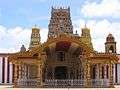
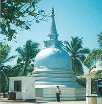 The Nagadeepa Purana Viharaya, one of the 16 Solosmasthana
Governance and politics
Sri Lankan Parliament
First elected representation at provincial level to a legislative came about after the Second Manning Reforms of the Legislative Council of Ceylon which assigned a seat to the Northern Province.[26] With universal adult suffrage been enabled through the Donoughmore Constitution, representatives from the province were elected to parliament.[26] Currently Two Electoral Districts, namely Jaffna Electoral District and Vanni Electoral District which elects 15 of the 225 members of the Sri Lankan Parliament.
Provincial council
Until 1978, the administration of the provinces in Sri Lanka where mainly carried out by the Government Agents of the districts.[27] Through the 13th Amendment to the 1978 Constitution of Sri Lanka and the Provincial Councils Act, No. 42 of 1987, Provincial council were established in the Provinces.[28]
The 13th Amendment to the 1978 Constitution of Sri Lanka established provincial councils. The first elections for provincial councils took place on 28 April 1988 in North Central, North Western, Sabaragamuwa, and Uva provinces.[29]
Elections in the newly merged North-East Province were scheduled for 19 November 1988. However, the Indian Peace Keeping Force (IPKF), which at that time occupied the North-East Province, rigged the elections in the north so that the Eelam People's Revolutionary Liberation Front (EPRLF) and Eelam National Democratic Liberation Front (ENDLF), two Indian backed paramilitary groups, won all of the 36 seats in the north uncontested.[30] However, elections did take place for the 35 seats in the east. The Sri Lanka Muslim Congress won 17 seats, EPRLF 12 seats, ENDLF 5 seats and the United National Party 1 seat. On 10 December 1988 Annamalai Varatharajah Perumal of the EPRLF became the first Chief Minister of the North-East Provincial Council.[30]
On 1 March 1990, just as the IPKF were preparing to withdraw from Sri Lanka, Permual moved a motion in the North-East Provincial Council declaraing an independent Eelam.[31]
Since the early 1990s parts of the north-east provinces were controlled by the LTTE, which according to the Sri Lankan government owned Sunday Observer newspaper, prevented elections [32][33] The north-east was governed directly from Colombo until May 2008 when elections were held in the demerged the Eastern Province which was followed by elections in the Northern Province in September 2013.[34]
Following the end of the civil war, G.A. Chandrasiri was sworn in as the Governor of Northern Province with effect 12 July 2009[35] and C. V. Vigneswaran was appointed Chief Minister of the Northern Province following the provincial council elections 2013.[36]
Political parties
Major Political parties in the province are Tamil National Alliance or also known as Ilankai Tamil Arasu Katchi, DTNA, United National Party, Sri Lanka Freedom Party and EPDP.
- Tamil National Alliance is a Sri Lankan Tamil political alliance in Sri Lanka. It was formed as an amalgamation of moderate Tamil parties as well as number of former rebel groups. It has participated in elections since 2001. The alliance supports self-determination in an autonomous state for the island's Tamils. It also supported negotiations with the rebel Liberation Tigers of Tamil Eelam to resolve the civil war in Sri Lanka. Three of its sitting Members of the Parliament K. Sivanesan, Joseph Pararajasingham and Nadarajah Raviraj have been assassinated since 2006 by LTTE during the war.
- Eelam People's Democratic Party is a Tamil political party and a former Pro-Government Paramilitary organization in Sri Lanka. It is led by its founder Douglas Devananda. It is based mainly in Jaffna district, specially in islands (Kayts Electoral Seat) which is the electoral seat of its founder, Douglas Devananda.
Economy
Majority of the people earn their livelihood as farmers, fishers and professionals in the civil and business sectors. Before the civil war cement and chemical industries along fishing with fishing made a major contribution to the economy. However now they have been abandoned and the factories are rusting. Close to a third of the population is unemployed far more than Sri Lanka and work is mostly informal and thus unstable. The population that managed to flee to foreign nations provide a steady flow of foreign remittances to their relatives in the province.[37] However, with the election victory of President Maithripala Sirisena and the removal of restrictions that prevented foreigners from visiting the north contributed to the sense of economic renewal alongside the development of Kankesanthurai Harbor the Palali Airport. Hospitals and schools as well as a cultural center and vocational training facility being built in Jaffna. Investments have also started to flow into an industries such as the Paranthan Chemical factory.[37]
Northern Province being an agricultural dominant province, where agricultural sector is 25.9% and trade sector comes next to it is 19.3%. Most of the people engaged in service sector covering 31.2% of the total.[38]
Gross State Domestic Product in Rs. Crores and Current Prices[38]
| Year | GSDP | Change | Share of Sri Lanka |
|---|---|---|---|
| 2001 | 29,490 | | |
| 2002 | 37,400 | ||
| 2003 | 43,123 | ||
| 2004 | 52,988 | ||
| 2005 | 64,004 | ||
| 2006 | 72,722 |
Transport


Transport infrastructure in the province is poorly developed and limits economic activity. Most people still use bullock carts for transportation.
Road
Major roads in Province are divided into two categories:
- A Class roads or National Highways - Maintained and controlled by Central Government.
- B Class roads or Provincial Highways - Maintained and controlled by Provincial Government.
There are number of underdeveloped C and D Class roads in the province.
Rail
Sri Lanka Railways operates the country’s railway network, including the Northern Line and the Mannar Line, in the Northern Province.
Most of the railways were developed during the British colonial period.
The railway lines between Vavuniya, Jaffna, and Kankesanthurai and between Medawachchiya and Talaimannar were destroyed during the civil war. For a time during reconstruction the Northern Line operated south of Pallai, while the Mannar Line operates between Medawachchiya and Madhu Road, but by 2015 it was reconstructed past Jaffna to its terminus at Kankesanthirai. Both lines are under reconstruction to restore the original network and upgrade the operating technology used.[39][40]
Air
Airways and airports are underdeveloped in this province. Palaly Airport is the primary airport in the province, once an international airport that had regular passenger flight service to Colombo and Trichirapalli, India. It is under the control of the Sri Lanka Navy now and is planned to be turned into an International airport again with the help of India.[41] Daily flights between Colombo and Jaffna are available. There are a few small airports and airstrips in Vavuniya and Iranamadu.
Education
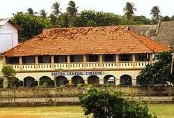
The Northern Province has one university, the University of Jaffna which became independent in 1979, previously having been a campus of the University of Sri Lanka since 1974.[42] The university has approximately 7,000 students. The province is known for its institutions of education, many of which were established by Christian missionaries.
| Districts | No. of Schools (1981) | No. of Schools (2006) |
|---|---|---|
| Jaffna | 488 | 410 |
| Kilinochchi | 85 | 96 |
| Mannar | 105 | 95 |
| Vavuniya | 183 | 188 |
| Mullaitivu | 100 | 103 |
Media
The first newspaper in Jaffna, Uthayatharakai (Morning Star) was published in 1841 by C.W. Thamotharampillai[43] By the 1940s, daily newspapers had already been started Eelakesari and Virakesari in 1930 and Thinakaran in 1932 and journals committed to the growth of modernistic, socially purposive literature Bharati and Marumalarchi in 1946 had also started coming out.
Few newspapers are published in the province now in the principal language of Tamil. None in English and Sinhala. Before the Civil war commenced dozens of newspapers and magazines were published. Press freedom is limited and mostly censored by Government and Pro-government paramilitaries.[44] Now most of the Tamil, English, Sinhala magazines come from Colombo and Chennai, India.
Notes
- ↑ Sri Lankan Tamil and Indian Tamil.
- ↑ Sri Lankan Moors and Indian Moors.
- ↑ 2001 Census was only carried out partially in the Northern province.
- ↑ Excludes Maritimepattu, Puthukudiyiruppu and Thunukkai divisions - no data available.
- ↑ Excludes Maritimepattu and Puthukudiyiruppu divisions - no data available.
- ↑ Roman Catholic and Other Christian.
References
- 1 2 3 4 "Area of Sri Lanka by province and district" (PDF). Statistical Abstract 2011. Department of Census & Statistics, Sri Lanka.
- 1 2 3 4 5 "A2 : Population by ethnic group according to districts, 2012". Census of Population & Housing, 2011. Department of Census & Statistics, Sri Lanka.
- 1 2 "A3 : Population by religion according to districts, 2012". Census of Population & Housing, 2011. Department of Census & Statistics, Sri Lanka.
- ↑ "Provinces of Sri Lanka". Statoids.
- 1 2 "Provincial Councils". Government of Sri Lanka.
- ↑ de Silva, K. M. (1981). A History of Sri Lanka. New Delhi: Oxford University Press. pp. xvii.
- ↑ Mills, Lennox A. (1933). Ceylon Under British Rule (1795 - 1932). London: Oxford University Press. pp. 67–68.
- ↑ Medis, G. C. (1946). Ceylon Under the British (2nd (revised) ed.). Colombo: The Colombo Apothecaries Co. pp. 39–40.
- ↑ Medis, G. C. (1946). Ceylon Under the British (2nd (revised) ed.). Colombo: The Colombo Apothecaries Co. p. 84.
- ↑ "Indo Sri Lanka Agreement, 1987". Tamil Nation.
- ↑ "The Constitution". Government of Sri Lanka.
- 1 2 3 "North-East merger illegal: SC". LankaNewspapers.com.
- ↑ Sambandan, V. S. (14 November 2003). "Sri Lanka's North-East to remain united for another year". The Hindu.
- ↑ "Papal Visit Rekindles Hopes in Former War Zone".
- ↑ Reuters (Jan 16, 2015). "Sri Lanka Scraps Ban on Foreigners Visiting Northern Former War Zone". New York Times Company. New York Times. Retrieved 30 January 2015.
- ↑ "A trip to Sri Lanka's Tamil country". BBC News. 22 August 2009.
- ↑ "Tamil leaders unite against invite to Sri Lanka for Modi's swearing-in". IBN Live. 23 May 2014.
- ↑ Chambers, Geoff (10 July 2014). "Asylum seekers returned home by Australian naval vessels complain the authorities took their iPhones, credit cards and cameras". The Daily Telegraph (Australia).
- ↑ Archived June 5, 2009, at the Wayback Machine.
- ↑ "Sri Lanka: largest cities and towns and statistics of their population". World Gazetteer.
- ↑ "Up to 100,000 killed in Sri Lanka's civil war: UN". ABC News (Australia). 20 May 2009.
- ↑ Harrison, Frances (23 July 2003). "Twenty years on - riots that led to war". BBC News.
- 1 2 "Enumeration of Vital Events 2011 - Northern Province" (PDF). Department of Census & Statistics, Sri Lanka.
- ↑ "Statistical Information 2010" (PDF). Northern Provincial Council.
- ↑ "Population by religion and district, Census 1981, 2001" (PDF). Statistical Abstract 2011. Department of Census & Statistics, Sri Lanka.
- 1 2 The Manning Constitutional Reforms (1920).
- ↑ How Did The Provincial Councils Become White Elephants?
- ↑ Hand book on Provincial councils
- ↑ Ethnic Conflict of Sri Lanka: Time Line - From Independence to 1999, ICES
- 1 2 Sri Lanka" The Untold Story by K T Rajasingham (via Asia Times)
- ↑ I'm no traitor, says Perumal, Sunday Island 10 September 2000
- ↑
- ↑ Opposition’s conspiracy with LTTE rump comes to light
- ↑ Commissioner of Elections Anounces Nomination Dates For North, Central and North Western Provincial Councils
- ↑ G A Chandrasiri re-appointed as NP Governor
- ↑ Wigneswaran receives CM appointment letter
- 1 2 "Is Sri Lanka's peace dividend finally within reach?".
- 1 2 http://www.np.gov.lk/pdf/development.pdf
- ↑ Bhattacharjya, Satarupa (17 January 2010). "Indian Railways makes a beeline for the Lankan tracks". The Sunday Times.
- ↑ "Agreement for supply and installation of Signaling & Telecommunication system for Northern railway network". Asian Tribune. 18 August 2011.
- ↑ "Palali airport to be upgraded to int'l level". 15 March 2013.
- ↑
- ↑ The Hindu : The first Madras graduate
- ↑ Wholesale attack on Tamil newspapers, Journalist kidnapped
External links
| Wikimedia Commons has media related to Northern Province, Sri Lanka. |
 |
Tamil Nadu, Palk Strait |
Bay of Bengal | Bay of Bengal | |
| Gulf of Mannar | |
Bay of Bengal | ||
| ||||
| | ||||
| North Western Province | North Central Province | Eastern Province |
| History | | ||||||||||||||||||
|---|---|---|---|---|---|---|---|---|---|---|---|---|---|---|---|---|---|---|---|
| Geography |
| ||||||||||||||||||
| Politics | |||||||||||||||||||
| Economy |
| ||||||||||||||||||
| Society |
| ||||||||||||||||||
| Symbols |
| ||||||||||||||||||