Opatrny Village Site
|
Opatrny Village Site | |
|
Overview of the site | |
  | |
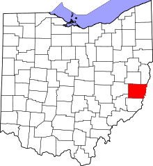
| Location | U.S. Route 40 north of the Belmont Hills Country Club[1] |
|---|---|
| Nearest city | St. Clairsville, Ohio |
| Coordinates | 40°4′29″N 80°56′36″W / 40.07472°N 80.94333°WCoordinates: 40°4′29″N 80°56′36″W / 40.07472°N 80.94333°W |
| Area | 50 acres (20 ha) |
| NRHP Reference # | 75001323[2] |
| Added to NRHP | May 21, 1975 |
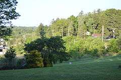
The Opatrny Village Site is an ancient village site dating from AD 1000-1600. The site was inhabited by the Monongahela culture and is a contemporary with the Fort Ancient cultural way of life. The property was placed on the National Register on 1975-05-21.
The extent of the site has not been fully determined as the artifacts lie in occupational debris over 1.5 feet thick. The site has been used as a pasture and remains largely intact. The property was placed to protect the integrity of the site from a highway project.
Around 1980, an extensive excavation was carried out at Opatrny; the information that it yielded was seen as highly significant in understanding the ways that local cultures changed and developed their surrounding terrain.[3]:367–368 Despite its location along U.S. Route 40, the village remains less disturbed by modern development than most surrounding terrain.[1]
References
- 1 2 Gray and Pape. National Road/U.S. 40 Historic Properties Inventory in Ohio, Vol. 1. Columbus: Ohio Department of Transportation, 1998-07-02, 65.
- ↑ National Park Service (2009-03-13). "National Register Information System". National Register of Historic Places. National Park Service.
- ↑ Myers, Thomas P., ed. "Current Research. American Antiquity 45 (1980): 355-376.
Further reading
- Ohio Historical Society, Division of Archeology; The Opatrny Village Site; Ohio Historical Society; Columbus, Ohio 1974
- "Radiocarbon Information from Eastern Ohio and a Summary of the Late Prehistoric Occupation at the Opatrny Village Site". Ohio Archaeologist 29.2 (1979): 40-41.
External links
| Topics | |
|---|---|
| Lists by states |
|
| Lists by insular areas | |
| Lists by associated states | |
| Other areas | |
| |