Phaethontis quadrangle
|
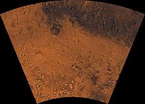
Map of Phaethontis quadrangle from Mars Orbiter Laser Altimeter (MOLA) data. The highest elevations are red and the lowest are blue. | |
| Coordinates | 47°30′S 150°00′W / 47.5°S 150°WCoordinates: 47°30′S 150°00′W / 47.5°S 150°W |
|---|---|

The Phaethontis quadrangle is one of a series of 30 quadrangle maps of Mars used by the United States Geological Survey (USGS) Astrogeology Research Program. The Phaethontis quadrangle is also referred to as MC-24 (Mars Chart-24).[1] The Phaethontis quadrangle lies between 30° and 65 ° south latitude and 120° and 180 ° west longitude on Mars. This latitude range is where numerous gullies have been discovered. An old feature in this area, called Terra Sirenum lies in this quadrangle; Mars Reconnaissance Orbiter discovered iron/magnesium smectites there.[2] Part of this quadrangle contains what is called the Electris deposits, a deposit that is 100–200 meters thick. It is light-toned and appears to be weak because of few boulders.[3] Among a group of large craters is Mariner Crater, first observed by the Mariner IV spacecraft in the summer of 1965. It was named after that spacecraft.[4] A low area in Terra Sirenum is believed to have once held a lake that eventually drained through Ma'adim Vallis.[5][6] Russia's Mars 3 probe landed in the Phaethontis quadrangle at 44.9° S and 160.1° W in December 1971. It landed at a speed of 75 km per hour, but survived to radio back 20 seconds of signal, then it went dead. Its message just appeared as a blank screen.[7]
Martian Gullies
The Phaethontis quadrangle is the location of many gullies that may be due to recent flowing water. Some are found in the Gorgonum Chaos[8][9] and in many craters near the large craters Copernicus and Newton (Martian crater).[10][11] Gullies occur on steep slopes, especially on the walls of craters. Gullies are believed to be relatively young because they have few, if any craters. Moreover, they lie on top of sand dunes which themselves are considered to be quite young. Usually, each gully has an alcove, channel, and apron. Some studies have found that gullies occur on slopes that face all directions,[12] others have found that the greater number of gullies are found on poleward facing slopes, especially from 30-44 S.[13]
Although many ideas have been put forward to explain them,[14] the most popular involve liquid water coming from an aquifer, from melting at the base of old glaciers, or from the melting of ice in the ground when the climate was warmer.[15][16] Because of the good possibility that liquid water was involved with their formation and that they could be very young, scientists are excited. Maybe the gullies are where we should go to find life.
There is evidence for all three theories. Most of the gully alcove heads occur at the same level, just as one would expect of an aquifer. Various measurements and calculations show that liquid water could exist in aquifers at the usual depths where gullies begin.[15] One variation of this model is that rising hot magma could have melted ice in the ground and caused water to flow in aquifers. Aquifers are layer that allow water to flow. They may consist of porous sandstone. The aquifer layer would be perched on top of another layer that prevents water from going down (in geological terms it would be called impermeable). Because water in an aquifer is prevented from going down, the only direction the trapped water can flow is horizontally. Eventually, water could flow out onto the surface when the aquifer reaches a break—like a crater wall. The resulting flow of water could erode the wall to create gullies.[17] Aquifers are quite common on Earth. A good example is "Weeping Rock" in Zion National Park Utah.[18]
As for the next theory, much of the surface of Mars is covered by a thick smooth mantle that is thought to be a mixture of ice and dust.[19][20][21] This ice-rich mantle, a few yards thick, smoothes the land, but in places it has a bumpy texture, resembling the surface of a basketball. The mantle may be like a glacier and under certain conditions the ice that is mixed in the mantle could melt and flow down the slopes and make gullies.[22][23] Because there are few craters on this mantle, the mantle is relatively young. An excellent view of this mantle is shown below in the picture of the Ptolemaeus Crater Rim, as seen by HiRISE.[24] The ice-rich mantle may be the result of climate changes.[25] Changes in Mars's orbit and tilt cause significant changes in the distribution of water ice from polar regions down to latitudes equivalent to Texas. During certain climate periods water vapor leaves polar ice and enters the atmosphere. The water comes back to ground at lower latitudes as deposits of frost or snow mixed generously with dust. The atmosphere of Mars contains a great deal of fine dust particles. Water vapor will condense on the particles, then fall down to the ground due to the additional weight of the water coating. When Mars is at its greatest tilt or obliquity, up to 2 cm of ice could be removed from the summer ice cap and deposited at midlatitudes. This movement of water could last for several thousand years and create a snow layer of up to around 10 meters thick.[26][27] When ice at the top of the mantling layer goes back into the atmosphere, it leaves behind dust, which insulating the remaining ice.[28] Measurements of altitudes and slopes of gullies support the idea that snowpacks or glaciers are associated with gullies. Steeper slopes have more shade which would preserve snow.[13] Higher elevations have far fewer gullies because ice would tend to sublimate more in the thin air of the higher altitude.[29]
The third theory might be possible since climate changes may be enough to simply allow ice in the ground to melt and thus form the gullies. During a warmer climate, the first few meters of ground could thaw and produce a "debris flow" similar to those on the dry and cold Greenland east coast.[30] Since the gullies occur on steep slopes only a small decrease of the shear strength of the soil particles is needed to begin the flow. Small amounts of liquid water from melted ground ice could be enough.[31][32] Calculations show that a third of a mm of runoff can be produced each day for 50 days of each Martian year, even under current conditions.[33]
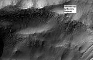 Electris Deposit, as seen by HiRISE. Electris deposit is light-toned and smooth in the image in contrast to rough materials below. Location is Phaethontis quadrangle.
 Layers in light-toned Electris Deposit, as seen by HiRISE on the Mars Reconnaissance Orbiter. Gullies are visible on the left.
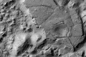
 Group of gullies on north wall of crater that lies west of the crater Newton (41.3047 degrees south latitude, 192.89 east longitide). Image taken with Mars Global Surveyor under the MOC Public Targeting Program.
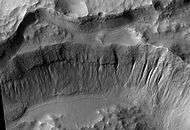 Crater wall inside Mariner Crater showing a large group of gullies, as seen by HiRISE.
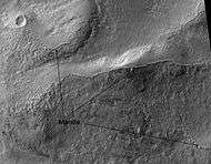 Ptolemaeus Crater Rim, as seen by HiRISE. Click on image to see excellent view of mantle deposit.
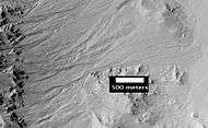 Gullies. Notice how channels curve around obstacles, as seen by HiRISE.
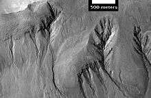 Gullies with branches, as seen by HiRISE.
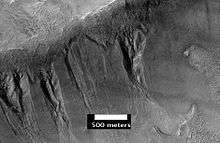 Group of deep gullies, as seen by HiRISE.
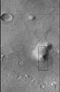 CTX image of the next image showing a wide view of the area. Since the hill is isolated it would be difficult for an aquifer to develop. Rectangle shows the approximate location of the next image.
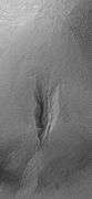 Gully on mound as seen by Mars Global Surveyor, under the MOC Public Targeting Program. Images of gullies on isolated peaks, like this one, are difficult to explain with the theory of water coming from aquifers because aquifers need large collecting areas.
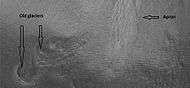 Another view of the previous gully on a mound. This one is with HiRISE, under the HiWish program. This view shows most of the apron and two old glaciers associated with it. All that is left of the glaciers are terminal moraines.
 MOLA context image for the series of three images to follow of gullies in a trough and nearby crater.
 Gullies in a trough and nearby crater, as seen by HiRISE under the HiWish program. Scale bar is 500 meters long.
 Close-up of gullies in crater, as seen by HiRISE under the HiWish program.
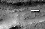 Close-up of gullies in trough, as seen by HiRISE under the HiWish program. These are some of the smaller gullies visible on Mars.
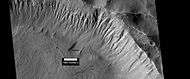 Gullies near Newton Crater, as seen by HiRISE, under the HiWish program. Place where there was an old glacier is labeled.
 HiRISE image, taken under HiWish program, of gullies in a crater in Terra Sirenum.
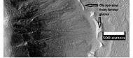 Gullies with remains of a former glacier in crater in Terra Sirenum, as seen by HiRISE under HiWish program.
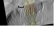 Gullies near Newton Crater, as seen by HiRISE under the HiWish Program.
 Gullies in a crater in Terra Sirenum, as seen by HiRISE under the HiWish Program.
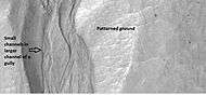 Close-up of gully showing multiple channels and patterned ground, as seen by HiRISE under the HiWish program.
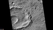 Gasa Crater, as seen by CTX Note: Gasa Crater is the smaller crater. It is believed the impact that created Gasa occurred in a debris-covered glacier.
 Gullies in Gasa Crater, as seen by HiRISE.
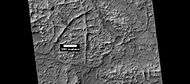
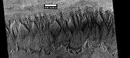 Gullies in crater in Phaethontis quadrangle, as seen by HiRISE under HiWish program
 Gullies in two levels of a crater wall, as seen by HiRISE under HiWish program. Gullies at two levels suggests they were not made with an aquifer, as was first suggested. Location is Phaethontis quadrangle.
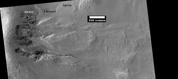 Image of gullies with main parts labeled. The main parts of a Martian gully are alcove, channel, and apron. Since there are no craters on this gully, it is thought to be rather young. Picture was taken by HiRISE under HiWish program. Location is Phaethontis quadrangle.
 Close-up of gully aprons showing they are free of craters; hence very young. Location is Phaethontis quadrangle. Picture was taken by HiRISE under HiWish program.
 Gullies in crater, as seen by HiRISE under HiWish program. Location is Phaethontis quadrangle.
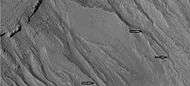 Close up of gullies in crater showing channels within larger valleys and curves in channels. These characteristics suggest they were made by flowing water. Note: this is an enlargement of the previous image by HiRISE under HiWish program. Location is Phaethontis quadrangle.
 Close up of gully network showing branched channels and curves; these characteristics suggest creation by a fluid. Note: this is an enlargement of a previous wide view of gullies in a crater, as seen by HiRISE under HiWish program. Location is Phaethontis quadrangle.
Tongue-shaped glaciers
 Tongue-shaped glacier, as seen by HiRISE under the HiWish program. Location is Phaethontis quadrangle.
 Wide view of several tongue-shaped glaciers on wall of crater, as seen by HiRISE under the HiWish program. The glaciers are of different sizes and lie at different levels. Some of these are greatly enlarged in pictures which follow.
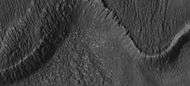 Close-up of the snouts of two glaciers from the previous image, as seen by HiRISE under the HiWish program. These are towards the bottom left of the previous image.
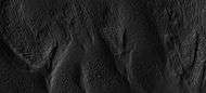 Close-up of small glaciers from a previous image, as seen by HiRISE under the HiWish program. Some of these glaciers seem to be just starting to form.
 Close-up of the edge of one of the glaciers on the bottom of the wide view from a previous image Picture was taken by HiRISE under the HiWish program.
Possible pingos
The radial and concentric cracks visible here are common when forces penetrate a brittle layer, such as a rock thrown through a glass window. These particular fractures were probably created by something emerging from below the brittle Martian surface. Ice may have accumulated under the surface in a lens shape; thus making these cracked mounds. Ice being less dense than rock, pushed upwards on the surface and generated these spider web-like patterns. A similar process creates similar sized mounds in arctic tundra on Earth. Such features are called “pingos,”, an Inuit word.[34] Pingos would contain pure water ice; thus they could be sources of water for future colonists of Mars.
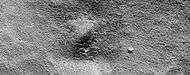 Possible pingo, as seen by HiRISE under HiWish program
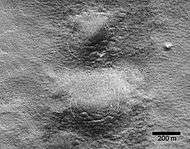 Possible pingos with scale, as seen by HiRISE under HiWish program
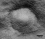 Close view of possible pingo with scale, as seen by HiRISE under HiWish program
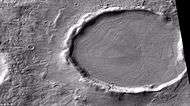
 Example of a pingo on Earth. On Earth the ice that caused the pingo would melt and fill the fractures with water; on Mars the ice would turn into a gas in the thin Martian atmosphere.
Concentric crater fill
Concentric crater fill, like lobate debris aprons and lineated valley fill, is believed to be ice-rich.[35] Based on accurate topography measures of height at different points in these craters and calculations of how deep the craters should be based on their diameters, it is thought that the craters are 80% filled with mostly ice.[36][37][38][39] That is, they hold hundreds of meters of material that probably consists of ice with a few tens of meters of surface debris.[40][41] The ice accumulated in the crater from snowfall in previous climates.[42][43][44] Recent modeling suggests that concentric crater fill develops over many cycles in which snow is deposited, then moves into the crater. Once inside the crater shade and dust preserve the snow. The snow changes to ice. The many concentric lines are created by the many cycles of snow accumulation. Generally snow accumulates whenever the axial tilt reaches 35 degrees.[45]
 Crater showing concentric crater fill, as seen by CTX (on Mars Reconnaissance Orbiter). Location is Phaethontis quadrangle.
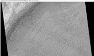 Close-up view of concentric crater fill, as seen by HiRISE under HiWish program Note: this is an enlargement of previous image of a concentric crater. Location is Phaethontis quadrangle.
Magnetic Stripes and Plate Tectonics
The Mars Global Surveyor (MGS) discovered magnetic stripes in the crust of Mars, especially in the Phaethontis and Eridania quadrangles (Terra Cimmeria and Terra Sirenum).[46][47] The magnetometer on MGS discovered 100 km wide stripes of magnetized crust running roughly parallel for up to 2000 km. These stripes alternate in polarity with the north magnetic pole of one pointing up from the surface and the north magnetic pole of the next pointing down.[48] When similar stripes were discovered on Earth in the 1960s, they were taken as evidence of plate tectonics. Researchers believe these magnetic stripes on Mars are evidence for a short, early period of plate tectonic activity. When the rocks became solid they retained the magnetism that existed at the time. A magnetic field of a planet is believed to be caused by fluid motions under the surface.[49][50][51] However, there are some differences, between the magnetic stripes on Earth and those on Mars. The Martian stripes are wider, much more strongly magnetized, and do not appear to spread out from a middle crustal spreading zone. Because the area containing the magnetic stripes is about 4 billion years old, it is believed that the global magnetic field probably lasted for only the first few hundred million years of Mars' life, when the temperature of the molten iron in the planet's core might have been high enough to mix it into a magnetic dynamo. There are no magnetic fields near large impact basins like Hellas. The shock of the impact may have erased the remnant magnetization in the rock. So, magnetism produced by early fluid motion in the core would not have existed after the impacts.[52]
When molten rock containing magnetic material, such as hematite (Fe2O3), cools and solidifies in the presence of a magnetic field, it becomes magnetized and takes on the polarity of the background field. This magnetism is lost only if the rock is subsequently heated above a particular temperature (the Curie point which is 770 °C for iron). The magnetism left in rocks is a record of the magnetic field when the rock solidified.[53]
Chloride Deposits
Using data from Mars Global Surveyor, Mars Odyssey and the Mars Reconnaissance Orbiter, scientists have found widespread deposits of chloride minerals. A picture below shows some deposits within the Phaethontis quadrangle. Evidence suggests that the deposits were formed from the evaporation of mineral enriched waters. The research suggests that lakes may have been scattered over large areas of the Martian surface. Usually chlorides are the last minerals to come out of solution. Carbonates, sulfates, and silica should precipitate out ahead of them. Sulfates and silica have been found by the Mars Rovers on the surface. Places with chloride minerals may have once held various life forms. Furthermore, such areas should preserve traces of ancient life.[54]
Based on chloride deposits and hydrated phyllosilicates, Alfonso Davila and others believe there is an ancient lakebed in Terra Sirenum that had an area of 30,000 km2 and was 200 meters deep. Other evidence that supports this lake are normal and inverted channels like ones found in the Atacama desert.[55]
 Evidence of water from chloride deposits in Phaethontis. Picture from HiRISE.
Fossae in Phaethontis quadrangle
 Icaria Fossae Graben, as seen by HiRISE. Click on image for a better view of Dust Devil Tracks.
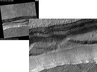 Sirenum Fossae Layers, as seen by HiRISE. Scale bar is 500 meters long.
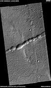 Pits in troughs, as seen by HiRISE under HiWish program
Strange Surfaces in Phaethontis quadrangle
 Surface of crater floor, as seen by HiRISE under HiWish program.
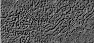 Surface of crater floor showing details from image taken with HiRISE, under HiWish program. This may be a transition from one type of structure to a different, maybe due to erosion.
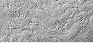
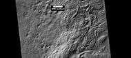 Surface showing large hollows of unknown origin, as seen by HiRISE under HiWish program.
 Close-up of surface with large hollows, as seen by HiRISE under HiWish program.
Craters in Phaethontis quadrangle
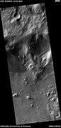
 Mesa in a crater, as seen by HiRISE under HiWish program.
 Layers in mantle, as seen by HiRISE under HiWish program.
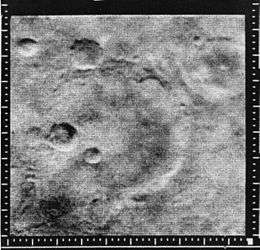 Mariner Crater, as seen by Mariner 4. This is probably the best picture that our first spacecraft to fly by Mars took.
 Pickering Crater lava flow, as seen by HiRISE. Click on image to see details at edge of flow.
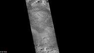 Hussey Crater, as seen by CTX camera (on Mars Reconnaissance Orbiter). Dark dots are dunes.
 Dune field in Hussey Crater, as seen by CTX camera (on Mars Reconnaissance Orbiter). Note: this is an enlargement of previous image.
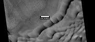 Dunes in Hussey Crater, as seen by HiRISE.
 Eastern edge of Copernicus Crater (Martian Crater), as seen by CTX camera (on Mars Reconnaissance Orbiter).
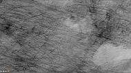 Dust devil tracks on floor of Copernicus Crater, as seen by CTX camera (on Mars Reconnaissance Orbiter). Note: this is an enlargement of the previous image of the eastern edge of Copernicus.
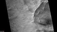 Gullies in small crater on rim of Copernicus Crater, as seen by CTX camera (on Mars Reconnaissance Orbiter). Note: this is an enlargement of a previous image of the eastern edge of Copernicus.
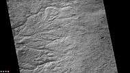 Channels on the floor of Copernicus Crater, as seen by CTX
 Possible dikes on floor of Copernicus Crater, as seen by CTX camera (on Mars Reconnaissance Orbiter). The straight lines may be dikes, faults, or joints.
 Eastern side of Very Crater, as seen by CTX camera (on Mars Reconnaissance Orbiter).
 Channel on floor of Very Crater, as seen by CTX camera (on Mars Reconnaissance Orbiter). Gullies are also visible in a smaller crater to the south (bottom). Note this is an enlargement of the previous image of Very.
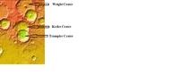 MOLA image showing the relationship among Wright, Keeler, and Trumpler Craters. Colors indicate elevations.
 Wright Crater, as seen by CTX camera (on Mars Reconnaissance Orbiter).
 Floor of Wright Crater, showing dust devil tracks, as seen by CTX camera (on Mars Reconnaissance Orbiter). Note: this is an enlargement of the previous image of Wright Crater.
 Trumpler Crater, as seen by CTX camera (on Mars Reconnaissance Orbiter). Dark band near the top is defrosting dunes.
 Enlargement of dunes along northern wall (near top of image) of Trumpler Crater, as seen by CTX camera (on Mars Reconnaissance Orbiter). In this image the dunes are not defrosting, as in another image. Dark lines at the top are dust devil tracks on the floor of keeler Crater. Note: this is an enlargement of the next image of Keeler Crater.
 Keeler Crater, as seen by CTX camera (on Mars Reconnaissance Orbiter).
 Li Fan Crater showing central mound, as seen by CTX camera (on Mars Reconnaissance Orbiter).
 West side of Nansen Crater, as seen by CTX camera (on Mars Reconnaissance Orbiter).
 East side of Nansen Crater, as seen by CTX camera (on Mars Reconnaissance Orbiter).
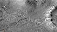 Small channels in Nansen Crater, as seen by CTX camera (on Mars Reconnaissance Orbiter). Note: this is an enlargement of the previous image of eastern side of Nansen Crater.
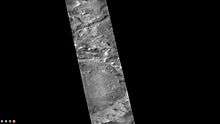 Kuiper Crater, as seen by CTX camera (on Mars Reconnaissance Orbiter).
 Liu Hsin Crater, as seen by CTX camera (on Mars Reconnaissance Orbiter).
 Dunes in Liu Hsin Crater, as seen by CTX camera (on Mars Reconnaissance Orbiter). Dark lines are dust devil tracks. Note: this is an enlargement of a previous image of Liu Sin Crater.
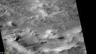 Dust devil tracks in Liu Hsin Crater, as seen by CTX camera (on Mars Reconnaissance Orbiter). Gullies can also be seen on the crater wall, near the bottom of picture. Note: this is an enlargement of a previous image of Liu Sin Crater.
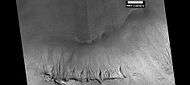 Gullies in Liu Hsin Crater, as seen by HiRISE under HiWish program. Curved lines on crater floor may be remains of old glaciers.
 East side of Hipparchus Crater, as seen by CTX camera (on Mars Reconnaissance Orbiter).
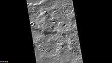 Small channels in Hipparchus Crater, as seen by CTX camera (on Mars Reconnaissance Orbiter). Note: this is an enlargement of the previous image of Hipparchus.
 Wide view of channels on rim of Hipparchus Crater, as seen by HiRISE under HiWish program
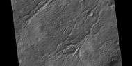 Close view of channels on rim of Hipparchus Crater, as seen by HiRISE under HiWish program
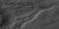 Close view of channels on rim of Hipparchus Crater, as seen by HiRISE under HiWish program
 Clark Crater, as seen by CTX camera (on Mars Reconnaissance Orbiter).
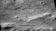 Dust devil tracks just outside north rim of Clark Crater, as seen by CTX camera (on Mars Reconnaissance Orbiter). Note: this is an enlargement of the previous image of Clark Crater.
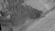 Dunes on floor of Clark Crater, as seen by CTX camera (on Mars Reconnaissance Orbiter). Some dust devil tracks are also visible as dark, thin streaks. Note: this is an enlargement of a previous image of Clark Crater.
Linear ridge networks
Linear ridge networks are found in various places on Mars in and around craters.[56] Ridges often appear as mostly straight segments that intersect in a lattice-like manner. They are hundreds of meters long, tens of meters high, and several meters wide. It is thought that impacts created fractures in the surface, these fractures later acted as channels for fluids. Fluids cemented the structures. With the passage of time, surrounding material was eroded away, thereby leaving hard ridges behind. Since the ridges occur in locations with clay, these formations could serve as a marker for clay which requires water for its formation.[57][58][59] Water here could have supported past life in these locations. Clay may also preserve fossils or other traces of past life.
 Linear ridge networks, as seen by HiRISE under HiWish program
 Close-up of linear ridge networks from the previous image, as seen by HiRISE under HiWish program
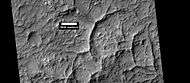 Linear ridge networks, as seen by HiRISE under HiWish program
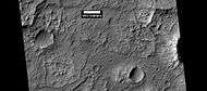 Linear ridge networks, as seen by HiRISE under HiWish program
Dunes
 Dunes in Newton (Martian crater), as seen by HiRISE under HiWish program
 Close view of dunes in Newton Crater, as seen by HiRISE under HiWish program
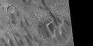 Close view of dunes in Newton Crater, as seen by HiRISE under HiWish program
- Close view of dunes in Newton Crater showing ripples on surface, as seen by HiRISE under HiWish program
Gallery
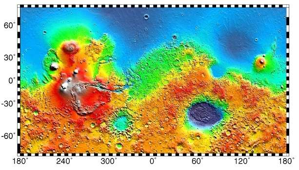
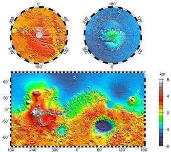 This topographic map shows volcanic peaks in white because of their great height. Near the equator, a line of three volcanoes points south to Phaethontis and three large craters-the area where there are many gullies. Click on the image for a good view.
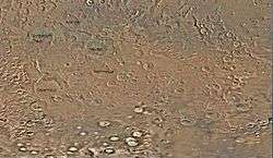 Map of Phaethontis quadrangle. Click on to enlarge and see some crater names.
 Close up image of Phaethontis surface taken with Mars Global Surveyor. Holes are thought to be caused by buried ice turning into a gas.
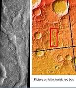 Tader Valles, as seen by THEMIS. Smooth material in channels may be a mantle in the form of dirty snow.
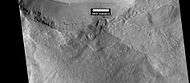 HiRISE image showing smooth mantle covering parts of a crater in the Phaethontis quadrangle. Along the outer rim of the crater, the mantle is displayed as layers. This suggests that the mantle was deposited multiple times in the past. Picture was taken with HiRISE under HiWish program. The layers are enlarged in the next image.
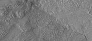 Enlargement of previous image of mantle layers. Four to five layers are visible. Location is the Phaethontis quadrangle.
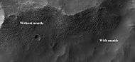 Surface showing appearance with and without mantle covering, as seen by HiRISE, under the HiWish program. Location is Terra Sirenum in Phaethontis quadrangle.
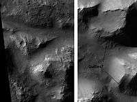 Atlantis Chaos, as seen by HiRISE. Click on image to see mantle covering and possible gullies. The two images are different parts of the original image. They have different scales.
 Oxbow lake, as seen by HiRISE under HiWish program
 Channel connecting two craters, as seen by HiRISE under HiWish program
Other Mars quadrangles
Interactive Mars map
See also
References
- ↑ Davies, M.E.; Batson, R.M.; Wu, S.S.C. (1992). "Geodesy and Cartography". In Kieffer, H.H.; Jakosky, B.M.; Snyder, C.W.; et al. Mars. Tucson: University of Arizona Press. ISBN 978-0-8165-1257-7.
- ↑ Murchie, S.; Mustard, John F.; Ehlmann, Bethany L.; Milliken, Ralph E.; et al. (2009). "A synthesis of Martian aqueous mineralogy after 1 Mars year of observations from the Mars Reconnaissance Orbiter" (PDF). Journal of Geophysical Research. 114: E00D06. Bibcode:2009JGRE..11400D06M. doi:10.1029/2009JE003342.
- ↑ Grant, J.; Wilson, Sharon A.; Noe Dobrea, Eldar; Fergason, Robin L.; et al. (2010). "HiRISE views enigmatic deposits in the Sirenum Fossae region of Mars". Icarus. 205: 53–63. Bibcode:2010Icar..205...53G. doi:10.1016/j.icarus.2009.04.009.
- ↑ Kieffer, Hugh H. (1992). Mars. Tucson: University of Arizona Press. pp. . ISBN 0-8165-1257-4.
- ↑ Irwin, Rossman P.; Howard, Alan D.; Maxwell, Ted A. (2004). "Geomorphology of Ma'adim Vallis, Mars, and associated paleolake basins". Journal of Geophysical Research. 109: 12009. Bibcode:2004JGRE..10912009I. doi:10.1029/2004JE002287.
- ↑ Michael Carr (2006). The surface of Mars. Cambridge, UK: Cambridge University Press. pp. . ISBN 0-521-87201-4.
- ↑ Hartmann, W. (2003). A Traveler's Guide to Mars. New York: Workman Publishing. p. . ISBN 978-0-7611-2606-5.
- ↑ http://hirise.lpl.arizona.edu/PSP_004071_1425
- ↑ http://hirise.lpl.arizona.edu/PSP_001948_1425
- ↑ http://hirise.lpl.arizona.edu/PSP_004163_1375
- ↑ U.S. department of the Interior U.S. Geological Survey, Topographic Map of the Eastern Region of Mars M 15M 0/270 2AT, 1991
- ↑ Edgett, K.; Malin, M. C.; Williams, R. M. E.; Davis, S. D. (2003). "Polar-and middle-latitude martian gullies: A view from MGS MOC after 2 Mars years in the mapping orbit" (PDF). Lunar Planet. Sci. 34. p. 1038, Abstract 1038. Bibcode:2003LPI....34.1038E.
- 1 2 Dickson, J; Head, J; Kreslavsky, M (2007). "Martian gullies in the southern mid-latitudes of Mars: Evidence for climate-controlled formation of young fluvial features based upon local and global topography" (PDF). Icarus. 188 (2): 315–323. Bibcode:2007Icar..188..315D. doi:10.1016/j.icarus.2006.11.020.
- ↑ http://www.psrd.hawaii.edu/Aug03/MartianGullies.html
- 1 2 Heldmann, J; Mellon, Michael T (2004). "Observations of martian gullies and constraints on potential formation mechanisms". Icarus. 168 (2): 285–304. Bibcode:2004Icar..168..285H. doi:10.1016/j.icarus.2003.11.024.
- ↑ Forget, F. et al. 2006. Planet Mars Story of Another World. Praxis Publishing. Chichester, UK.
- ↑ http://www.space.com/scienceastronomy/mars_aquifer_041112.html
- ↑ Harris, A and E. Tuttle. 1990. Geology of National Parks. Kendall/Hunt Publishing Company. Dubuque, Iowa
- ↑ Malin, Michael C.; Edgett, Kenneth S. (2001). "Mars Global Surveyor Mars Orbiter Camera: Interplanetary cruise through primary mission". Journal of Geophysical Research. 106: 23429–23570. Bibcode:2001JGR...10623429M. doi:10.1029/2000JE001455.
- ↑ Mustard, JF; Cooper, CD; Rifkin, MK (2001). "Evidence for recent climate change on Mars from the identification of youthful near-surface ground ice." (PDF). Nature. 412 (6845): 411–4. doi:10.1038/35086515. PMID 11473309.
- ↑ Carr, Michael H. (2001). "Mars Global Surveyor observations of Martian fretted terrain". Journal of Geophysical Research. 106: 23571–23595. Bibcode:2001JGR...10623571C. doi:10.1029/2000JE001316.
- ↑ http://www.msnbc.msn.com/id/15702457?
- ↑ Head, J. W.; Marchant, D. R.; Kreslavsky, M. A. (2008). "From the Cover: Formation of gullies on Mars: Link to recent climate history and insolation microenvironments implicate surface water flow origin". Proceedings of the National Academy of Sciences. 105 (36): 13258–63. Bibcode:2008PNAS..10513258H. doi:10.1073/pnas.0803760105. PMC 2734344
 . PMID 18725636.
 - ↑ Christensen, PR (2003). "Formation of recent martian gullies through melting of extensive water-rich snow deposits.". Nature. 422 (6927): 45–8. Bibcode:2003Natur.422...45C. doi:10.1038/nature01436. PMID 12594459.
- ↑ http://news.nationalgeographic.com/news/2008/03/080319-mars-gullies_2.html
- ↑ Jakosky, Bruce M.; Carr, Michael H. (1985). "Possible precipitation of ice at low latitudes of Mars during periods of high obliquity". Nature. 315 (6020): 559–561. Bibcode:1985Natur.315..559J. doi:10.1038/315559a0.
- ↑ Jakosky, Bruce M.; Henderson, Bradley G.; Mellon, Michael T. (1995). "Chaotic obliquity and the nature of the Martian climate". Journal of Geophysical Research. 100: 1579–1584. Bibcode:1995JGR...100.1579J. doi:10.1029/94JE02801.
- ↑ MLA NASA/Jet Propulsion Laboratory (December 18, 2003). "Mars May Be Emerging From An Ice Age". ScienceDaily. Retrieved February 19, 2009.
- ↑ Hecht, M (2002). "Metastability of liquid water on Mars" (PDF). Icarus. 156 (2): 373–386. Bibcode:2002Icar..156..373H. doi:10.1006/icar.2001.6794.
- ↑ Peulvast, J.P. (1988). "Mouvements verticaux et genèse du bourrelet Est-groenlandais. dans la région de Scoresby Sund". Physio Géo (in French). 18: 87–105.
- ↑ Costard, F.; Forget, F.; Mangold, N.; Mercier, D.; et al. (2001). "Debris Flows on Mars: Analogy with Terrestrial Periglacial Environment and Climatic Implications" (PDF). Lunar and Planetary Science. XXXII: 1534. Bibcode:2001LPI....32.1534C.
- ↑ http://www.spaceref.com:16090/news/viewpr.html?pid=7124,
- ↑ Clow, G (1987). "Generation of liquid water on Mars through the melting of a dusty snowpack". Icarus. 72: 93–127. Bibcode:1987Icar...72...95C. doi:10.1016/0019-1035(87)90123-0.
- ↑ http://www.uahirise.org/ESP_046359_1250
- ↑ Levy, J. et al. 2009. Concentric crater fill in Utopia Planitia: History and interaction between glacial "brain terrain" and periglacial processes. Icarus: 202. 462-476.
- ↑ Levy, J., J. Head, D. Marchant. 2010. Concentric Crater fill in the northern mid-latitudes of Mars: Formation process and relationships to similar landforms of glacial origin. Icarus 2009, 390-404.
- ↑ Levy, J., J. Head, J. Dickson, C. Fassett, G. Morgan, S. Schon. 2010. Identification of gully debris flow deposits in Protonilus Mensae, Mars: Characterization of a water-bearing, energetic gully-forming process. Earth Planet. Sci. Lett. 294, 368–377.
- ↑ http://hirise.lpl.arizona.edu/ESP_032569_2225
- ↑ Garvin, J., S. Sakimoto, J. Frawley. 2003. Craters on Mars: Geometric properties from gridded MOLA topography. In: Sixth International Conference on Mars. July 20–25, 2003, Pasadena, California. Abstract 3277.
- ↑ Garvin, J. et al. 2002. Global geometric properties of martian impact craters. Lunar Planet. Sci: 33. Abstract # 1255.
- ↑ http://photojournal.jpl.nasa.gov/catalog/PIA09662
- ↑ Kreslavsky, M. and J. Head. 2006. Modification of impact craters in the northern planes of Mars: Implications for the Amazonian climate history. Meteorit. Planet. Sci.: 41. 1633-1646
- ↑ Madeleine, J. et al. 2007. Exploring the northern mid-latitude glaciation with a general circulation model. In: Seventh International Conference on Mars. Abstract 3096.
- ↑ http://hirise.lpl.arizona.edu/PSP_002917_2175
- ↑ Fastook, J., J.Head. 2014. Concentric crater fill: Rates of glacial accumulation, infilling and deglaciation in the Amazonian and Noachian of Mars. 45th Lunar and Planetary Science Conference (2014) 1227.pdf
- ↑ Barlow, Nadine G. (2008). Mars: an introduction to its interior, surface and atmosphere. Cambridge, UK: Cambridge University Press. pp. . ISBN 978-0-521-85226-5.
- ↑ Philippe Lognonné; François Forget; François Costard (2007). Planet Mars: Story of Another World (Springer Praxis Books / Popular Astronomy). Praxis. pp. . ISBN 0-387-48925-8.
- ↑ Fredric W. Taylor (2010). The Scientific Exploration of Mars. Cambridge, UK: Cambridge University Press. pp. . ISBN 0-521-82956-9.
- ↑ Connerney JE; Acuna MH; Wasilewski PJ; et al. (April 1999). "Magnetic lineations in the ancient crust of mars" (PDF). Science. 284 (5415): 794–8. Bibcode:1999Sci...284..794C. doi:10.1126/science.284.5415.794. PMID 10221909.
- ↑ Langlais, B. (2004). "Crustal magnetic field of Mars" (PDF). Journal of Geophysical Research. 109. Bibcode:2004JGRE..10902008L. doi:10.1029/2003JE002048.
- ↑ Connerney, J. E. P.; Acuña, MH; Ness, NF; Kletetschka, G; et al. (2005). "Tectonic implications of Mars crustal magnetism". Proceedings of the National Academy of Sciences. 102 (42): 14970–14975. Bibcode:2005PNAS..10214970C. doi:10.1073/pnas.0507469102. PMC 1250232. PMID 16217034.
- ↑ Acuna, MH; Connerney, JE; Ness, NF; Lin, RP; Mitchell, D; Carlson, CW; McFadden, J; Anderson, KA; et al. (1999). "Global distribution of crustal magnetization discovered by the Mars Global Surveyor MAG/ER Experiment". Science. 284 (5415): 790–793. Bibcode:1999Sci...284..790A. doi:10.1126/science.284.5415.790. PMID 10221908.
- ↑ http://sci.esa.int/science-e/www/object/index.cfm?fobjectid=31028&fbodylongid=645
- ↑ Osterloo, M. M.; Hamilton, V. E.; Bandfield, J. L.; Glotch, T. D.; et al. (2008). "Chloride-Bearing Materials in the Southern Highlands of Mars". Science. 319 (5870): 1651–1654. Bibcode:2008Sci...319.1651O. doi:10.1126/science.1150690. PMID 18356522.
- ↑ Davila, A. et al. 2011. A large sedimentary basin in the Terra Sirenum region of the southern highlands of Mars. Icarus. 212: 579-589.
- ↑ Head, J., J. Mustard. 2006. Breccia dikes and crater-related faults in impact craters on Mars: Erosion and exposure on the floor of a crater 75 km in diameter at the dichotomy boundary, Meteorit. Planet Science: 41, 1675-1690.
- ↑ Mangold et al. 2007. Mineralogy of the Nili Fossae region with OMEGA/Mars Express data: 2. Aqueous alteration of the crust. J. Geophys. Res., 112, doi:10.1029/2006JE002835.
- ↑ Mustard et al., 2007. Mineralogy of the Nili Fossae region with OMEGA/Mars Express data: 1. Ancient impact melt in the Isidis Basin and implications for the transition from the Noachian to Hesperian, J. Geophys. Res., 112.
- ↑ Mustard et al., 2009. Composition, Morphology, and Stratigraphy of Noachian Crust around the Isidis Basin, J. Geophys. Res., 114, doi:10.1029/2009JE003349.
- 1 2 Morton, Oliver (2002). Mapping Mars: Science, Imagination, and the Birth of a World. New York: Picador USA. p. 98. ISBN 0-312-24551-3.
- ↑ "Online Atlas of Mars". Ralphaeschliman.com. Retrieved December 16, 2012.
- ↑ "PIA03467: The MGS MOC Wide Angle Map of Mars". Photojournal. NASA / Jet Propulsion Laboratory. February 16, 2002. Retrieved December 16, 2012.
- ↑ "Online Atlas of Mars". Ralphaeschliman.com. Retrieved December 16, 2012.
- ↑ "PIA03467: The MGS MOC Wide Angle Map of Mars". Photojournal. NASA / Jet Propulsion Laboratory. February 16, 2002. Retrieved December 16, 2012.
External links
| Wikimedia Commons has media related to Phaethontis quadrangle. |
- General review of many of the theories involving the origin of gullies.
- Dickson, J; Head, J; Kreslavsky, M (2007). "Martian gullies in the southern mid-latitudes of Mars: Evidence for climate-controlled formation of young fluvial features based upon local and global topography" (PDF). Icarus. 188 (2): 315–323. Bibcode:2007Icar..188..315D. doi:10.1016/j.icarus.2006.11.020. Gives a good review of the history of the discovery of gullies.
- Martian Ice - Jim Secosky - 16th Annual International Mars Society Convention
| Quadrangles on Mars | ||||||||||||||||||||||||||||||||||||||||||||||||||||||||||||||||||||||||||||||||||||||||||||||||||||||||||||||||||||||||||||||||||||||||||||||||
|---|---|---|---|---|---|---|---|---|---|---|---|---|---|---|---|---|---|---|---|---|---|---|---|---|---|---|---|---|---|---|---|---|---|---|---|---|---|---|---|---|---|---|---|---|---|---|---|---|---|---|---|---|---|---|---|---|---|---|---|---|---|---|---|---|---|---|---|---|---|---|---|---|---|---|---|---|---|---|---|---|---|---|---|---|---|---|---|---|---|---|---|---|---|---|---|---|---|---|---|---|---|---|---|---|---|---|---|---|---|---|---|---|---|---|---|---|---|---|---|---|---|---|---|---|---|---|---|---|---|---|---|---|---|---|---|---|---|---|---|---|---|---|---|---|
| ||||||||||||||||||||||||||||||||||||||||||||||||||||||||||||||||||||||||||||||||||||||||||||||||||||||||||||||||||||||||||||||||||||||||||||||||