River Sett
| River Sett | |
|---|---|
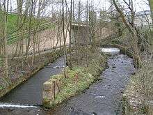 The Sett passes under the A624 Hayfield "bypass". The tower of St. Matthew's church can be seen through the trees in the background, and in the foreground are the scanty remains of Walk Mill. | |
 The River Sett is highlighted in red Coordinates: 53°21′52″N 2°00′00″W / 53.36440°N 1.99990°W | |
| Country | England |
| Basin | |
| Main source |
Kinder Scout c.540 metres (1,770 ft)[1] |
| River mouth |
River Goyt c.130 metres (430 ft)[1] |
| Features | |
| Tributaries |
|
The River Sett is a river that flows through the High Peak borough of Derbyshire, in north western England. It rises near Edale Cross on Kinder Scout and flows through the villages of Hayfield and Birch Vale to join the River Goyt at New Mills.[1] The River Goyt is one of the principal tributaries of the River Mersey.
The 2.5-mile Sett Valley Trail follows the trackbed of the former railway line between Hayfield and New Mills.[2]
References
| Unitary authorities | |
|---|---|
| Boroughs or districts | |
| Major settlements |
|
| Rivers | |
| Topics | |
This article is issued from Wikipedia - version of the 6/16/2016. The text is available under the Creative Commons Attribution/Share Alike but additional terms may apply for the media files.