Staveley, Derbyshire
| Staveley | |
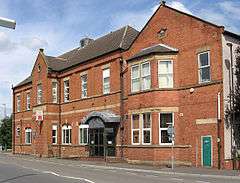 Staveley – Miners Welfare |
|
 Staveley |
|
| Population | 18,247 (Including Barrow Hill ,Beighton Fields , Mastin Moor and Poolsbrook. civil parish, 2011)[1] |
|---|---|
| OS grid reference | SK434749 |
| District | Chesterfield |
| Shire county | Derbyshire |
| Region | East Midlands |
| Country | England |
| Sovereign state | United Kingdom |
| Post town | CHESTERFIELD |
| Postcode district | S43 |
| Dialling code | 01246 |
| Police | Derbyshire |
| Fire | Derbyshire |
| Ambulance | East Midlands |
| EU Parliament | East Midlands |
| UK Parliament | Chesterfield |
|
|
Coordinates: 53°16′10″N 1°20′54″W / 53.2694°N 1.3484°W
Staveley is a town within the borough of Chesterfield, in Derbyshire, England. The town is situated alongside the River Rother, adjacent to Eckington to the north, Barlborough to the east, Sutton-cum-Duckmanton civil parish to the south and Brimington to the west.
History
Staveley has traditionally been a mining town with several large mining pits situated in and around the area, with the closest being Ireland Pit (Ireland Colliery Brass Band is named after this colliery). However this pit has now closed down along with the others in the area.
Staveley Miners Welfare on Market Street was built in 1893 as an indoor market hall by Charles Paxton Markham. At that time it was called Markham Hall in memory of his father.[2] Markham played a large role in the industrial development of the area around Staveley. Through his company Markham & Co. and its successor Staveley Coal and Iron Company, Markham owned ironstone quarries, several coal mines (including Markham Colliery), chemical works, ironworks and an engineering works specialising in mining and tunnelling equipment.
Other major local industries in recent history have included Staveley Works foundry and Staveley Chemicals. The nationwide decline in industry has meant that Staveley Chemicals and Staveley Works have now almost entirely closed, with the only section of the chemical plant remaining being the P-aminophenol plant (a key component to making Paracetamol), which is run by American/Irish company Covidien. Notice has been served on the plant, earmarked for closure around June 2012, this closure will mark the end of over 100 yrs. of chemical production at Staveley..
It is also the home town of the Townes Brewery.[3] Modern industry includes a plastic pipe moulding factory for Brett Martin plc. There was also a wood wool production unit on Staveley works.
The New Markham Vale Loop Road has been completed and opens up the former Markham coal field areas to development, linking the town to a new junction (29A) on the M1 motorway, this junction opened in early July 2008. This is part funded by European Union regeneration money. The scheme also reinstates part of the former Chesterfield Canal which crosses the route. There is a long term project to reinstate the canal from Chesterfield to Kiveton where it currently terminates. Sections from Chesterfield to Brimington were reinstated as part of previous stages of the Chesterfield Bypass and opencast schemes on part of the former Staveley Coal and Iron Company site which was part of British Steel Corporation following Nationalisation. The new Staveley Town Basin was officially opened on 30 June 2012 and forms the centre piece of the imaginative redevelopment of the Chesterfield Canal in Staveley. The basin is designed to provide facilities to enable the economic development of the isolated section in advance of full restoration. It will provide secure short- and long-term moorings, slipway, car parking, cycle racks, toilets and showers as well as a large open play area which can also be used for major waterway events and festivals.[4]
As part of the Markham Vale scheme to regenerate the site of the former Markham Colliery site there was a proposal to build a "Solar Pyramid" to form the world's largest functional timepiece.[5] This project has now been cancelled. However on the site near Poolsbrook Country Park, a caravan site for tourists has now been built boosting numbers to the country park. The area has several trails for walkers and mountain bikers along former pit railway lines.
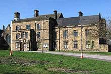
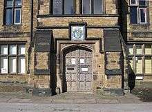

Staveley Hall
Staveley Hall is situated to the northeast of St John The Baptist Church in Staveley, with vehicular access from the Lowgates traffic island. The Hall in its present form was built by Sir Peter Frecheville in 1604. Before the current building there had been buildings on this site for over 700 years. A brief history of the building and its ownership follows:
- Hascuit de Musard was awarded the Manor of Staveley after the Norman Conquest of 1066.
- In 1306 the Musard family died out and Ralph de Frecheville became the new Lord.
- The Frechevilles lived in the Hall until they died out in 1682. In 1603 Sir Peter de Frecheville was knighted by James I at Worksop and he wished to make Staveley Hall a suitable residence for a knight and Justice of the Peace.
- The architect of Sir Peter de Frechevilles house is not known but may well be Huntingdon Smithson – the architect employed by the Cavendish's at Bolsover Castle.
- In 1682 and the house was sold to the Cavendish family. James Cavendish died in 1751 and the Hall and Park reverted to The Duke of Devonshire.
- In 1756 the Rector of Staveley managed to persuade the Duke of Devonshire to allow his son (and then a series of clerics) to live there.
- It remained as a rectory until bought by Staveley Urban District Council in 1967.
- The Hall was designated by English Heritage as a listed building (grade II) in 1974.
- Upon Local Government reorganisation in 1974 ownership passed to Chesterfield Borough Council and it was eventually bought by Staveley Town Council.[2][6][7][8][9]
Notable people
- Nicholas Richard Ainger, a member of parliament, was educated here, at Netherthorpe School. The school was established in 1572 by four local notable families; Frecheville, De Rodes and Sitwell, which today comprise the school houses, and Cavendish.
- John Frescheville, 1st Baron Frescheville, who family seat was in Staveley was elected a member of parliament 1628–9 and 1661–9. He was a Deputy Lieutenant for the county in 1639–42 and 1660, a Justice of the Peace from 1660, and a Gentleman of the Privy Chamber in 1639–45.
- Francis Rodes, judge, was born here and built the nearby Barlborough Hall as well as helping to found Netherthorpe School.[10]
- Thomas Rawson Birks, Cambridge Professor was born here 1810.
- Harry and Will Lilley, footballers who played for Sheffield United were born here in 1868 and 1885 respectively.
- Sam Raybould, Liverpool striker, born here 1875.
- Chris Spedding, rock and roll and jazz guitarist, born here 1944.
- W.M. Hodgkins, artist and activist.
- Kerry Hallam, artist, folk musician and writer, born here 1937.
References
- ↑ "Neighbourhood Statistics". Office for National Statistics. Retrieved 3 January 2015.
- 1 2 "Staveley Town Centre Trail". Staveley Town Council. Retrieved 14 August 2015.
- ↑ "Real Ales @ Townes Brewery". townesbrewery.com. Retrieved 31 May 2014.
- ↑ Richardson, Christine, Lower John (2010). Chesterfield Canal – A Richlow Guide. Richlow. ISBN 978-0-9552609-4-0
- ↑ "UK | England | First glimpse of giant pyramid". BBC News. 15 October 2002.
- ↑ "Staveley Hall Listing". Heritage Gateway. Retrieved 14 August 2015.
- ↑ "Staveley Conservation Area Appraisal" (PDF). Chesterfield Borough Council. Retrieved 14 August 2015.
- ↑ Pevsner, Nikolaus (2002). The Buildings of England – Derbyshire. Yale University Press. ISBN 0-300-09591-0.
- ↑ Craven, Maxwell; Stanley, Michael (1982). The Derbyshire Country House. Derbyshire Museum Service. ISBN 0-906753-01-5.
- ↑ Whites 1857 Directory of Derbyshire p. 770-780
External links
- Various related information but in particular documenting the 2006 Archaeological dig that took place in the grounds of Staveley Hall
- Official Town Guide to Staveley
- Spire and District Online – Community Website originated in Staveley and run for the local area
- Photographs of the Last Remaining parts of the Staveley Coal and Iron Company (Last used as a Pipe Foundry)
| Unitary authorities | |
|---|---|
| Boroughs or districts | |
| Major settlements |
|
| Rivers | |
| Topics | |