Sacramento Northern Railway
|
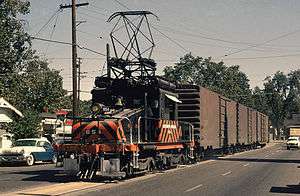
A GE Steeplecab street-running in Yuba City, California in 1964 | |
| Reporting mark | SN |
|---|---|
| Locale | Central and Northern California |
| Dates of operation | 1918–1983 |
| Predecessor | Northern Electric Railway |
| Successor | Western Pacific Railroad |
| Track gauge | 4 ft 8 1⁄2 in (1,435 mm) |
| Headquarters | Marysville, California |
The Sacramento Northern Railway (reporting mark SN) was an 183-mile (295 km) electric interurban railway that connectected Chico in northern California with Oakland via the California capital, Sacramento. In its operation it ran directly on the streets of Oakland, Sacramento, Yuba City, Chico, and Woodland and ran passenger service until 1941 and freight service into the 1960s.
History
Summary
The Sacramento Northern (SN) was an electrified interurban railroad in California that extended 183 miles from Oakland north to Chico. There were two branches, one to Woodland-Colusa, and the other to Oroville. The SN had been two separate interurban companies connecting at Sacramento until 1925. The Oakland, Antioch, and Eastern Railway was a trolley-wire powered line that ran from Oakland through a tunnel in the Oakland hills to Moraga, Walnut Creek, Concord, Pittsburg, to Sacramento. It was renamed the San Francisco-Sacramento Railroad briefly. The Northern Electric Railway was a third-rail powered line that ran from Sacramento north through Marysville-Yuba City to Chico. The train crossed the Template:Sacramento River on the Red Gate Bridge. It was renamed the Sacramento Northern Railroad in 1914. In 1928, the two lines combined to become the Sacramento Northern Railway and came under control of the Western Pacific Railroad which operated it as a separate entity. An extensive multiple-car passenger service operated from Oakland to Chico until 1941 including providing dining car service on some trains. Passenger traffic was heaviest from Sacramento to Oakland. Freight operation using electric locomotives continued into the 1960s. The SN was a typical interurban in that its trains, including freight, ran on downtown city streets in Oakland, Sacramento, Yuba City, and Woodland. This involved multiple car trains making sharp turns at street corners and obeying traffic signals.[1] Once in open country, SN's passenger trains ran at fairly fast speeds. With its shorter route and lower fares, the SN provided strong competition to the Southern Pacific and Western Pacific railroads for passenger business and minor freight business between those two cities. North of Sacramento, rail business was less due to the small town agricultural nature of the region with is small towns and by competition from the SP Railroad.
Detailed history
The original, 93-mile (150 km) route connected Chico with Sacramento. The original name of this line was the Chico Electric Railway (CERY), in operation from 1904 to 1905.[2] CERY was sold in 1905, after a few months of operation, to the Northern Electric Railway (NER). The NER went into bankruptcy in 1914, and was acquired by a new corporation named the Sacramento Northern Railroad (SNRR).
The Western Pacific Railroad (WP) purchased the SNRR in 1922 as a subsidiary and kept the original name. In 1925 the WP created a "new" Sacramento Northern Railway (SNRy), in order to group the growing collection of WP interurban railroad holdings.
The Sacramento Northern Railway was created from two interurban railroads:
- Northern Electric Railway — the third-rail-powered "North End" from Sacramento north through the agricultural Sacramento Valley to Marysville-Yuba City and Chico from late 1905 to 1918. It became the Northern Division of the SNRy.
- San Francisco-Sacramento Railroad — the trolley-wire-powered "South End" operated from Sacramento south through farmland, marshes, over a bay by its own ferry, to Pittsburg-Concord, through the Contra Costa County hills and tunnel to Oakland and the Key System ferry pier. In 1928 the San Francisco-Sacramento Railroad (formerly the Oakland, Antioch and Eastern Railway, and originally the Oakland and Antioch Railway) became the Southern Division of the SNRy.
By retaining the Sacramento Northern Railway as a subsidiary rather than just absorbing it into the Western Pacific Railroad, the WP earned more income by interchanging freight with a separate Sacramento Northern Railroad due to extra fees earned from shipper-customers by interchanging freight from one railroad (itself) to another (the Sacramento Northern). Western Pacific also owned regional sister electric railroads, the Tidewater Southern Railway (TS) (Stockton to Modesto) and the Central California Traction Company (CCT) (Stockton to downtown Sacramento). The TS and the CCT used the same downtown Sacramento terminal and ran directly on Sacramento streets.
The two divisions used different voltages as well as different methods of current collection, thus only some powered equipment could traverse the entire Chico to Oakland route. When in Oakland, SN used Key System power. Some equipment carried a third rail shoe, a trolley pole, and a pantograph. The differing electrical systems, third rail for the North End and trolley wire for the South End, were retained. Some passenger interurban cars and freight locomotives were designed to operate on both "Ends" but most could not and had to remain on their home divisions.[3]
The combined main line extended for 183 miles (295 km) between San Francisco and Chico. At the southern end the SNRy shared track, electric propulsion power, and facilities of the East Bay's expansive Key System commuter lines. At first this used the Key System's ferry terminal at the Oakland Mole in West Oakland. Then beginning in 1939 it used the tracked lower deck of the San Francisco–Oakland Bay Bridge into the Transbay Terminal in San Francisco. After 1958, the Key System ceased operating, and the tracks were removed from streets and the Bay Bridge.
Service
In June 1939 SN, had three weekday trains from Chico to San Francisco, one Sacramento train to SF, and three Concord to SF trains. The fastest train took 5 hr 43 min Chico to San Francisco and 2 hr 48 min Sacramento to SF. Passenger service west from Sacramento ended in August 1940. In January 1941, SN operated two weekday trains from Pittsburg to San Francisco and two Concord trains to SF. Passenger service totally ended in 1941[4] and SN was a shortline freight-hauling railroad thereafter.
At 183 miles (295 km), the SN was one of the longest interurban lines in the nation and was built and operated to first-class railroad standards including dining and parlor car service at speeds up to 60 miles (97 km) per hour.[5] As with most interurban railroads in the US, its return on initial investment was lower and its annual operating costs were higher than had been projected at conception. Interurbans, like most railroads, were more labor-intensive than expected in shops maintaining their rolling stock and repairing electrical systems.[6] Passenger business was less than projected and became increasingly unprofitable, even after SN reached downtown San Francisco via the new San Francisco–Oakland Bay Bridge in 1939. Its freight business and its relationship with the adjacent Western Pacific Railroad was the lifeblood of the railroad, keeping it in profit long after passenger service had ceased. Although it had a somewhat shorter route from Oakland to Pittsburg/Antioch in competing with the Santa Fe and Southern Pacific steam railroads, its route through the Oakland Hills was steep (4%) and curvy by railroad standards plus it had on-street operation in Oakland. Freight trains usually had just a few cars on those grades with locomotives ("juice jacks") at both ends of the train. From Sacramento north to Chico, the SN competed with the Southern Pacific Railroad and, up to 1922, with the Western Pacific from Marysville south. It traversed a low density population rural farm country from Chico which contained only Marysville-Yuba City as major towns before it reaching Sacramento. Thus, passenger business north of Sacramento was light and could not be expected to increase. The SN had branches to Vacaville and Dixon, Woodland, Marysville and Colusa, and Oroville.[7]
The railway suffered from the Great Depression and the rise of the automobile. Interurban passenger service ended in 1941, while streetcar service in Chico continued until 1947. Other travails were the 1951 Lisbon Trestle Collapse, in which crewmen were hurt and a long causeway trestle needing rebuilding,[8] and the withdrawal of the Sacramento Northern's aging train ferry, "Ramon" and service on the Dixon Branch.
Freight service continued and was heavy during World War II. In 1956 SN reported 45 million ton-miles of revenue freight; at the end of the year it operated 349 miles of road and 452 miles of track. 1956 operating revenue was $2.2 million, but in that year ICC included SN among the Class Is.
In 1944 the railroad received its first diesel locomotives, which began the process of de-electrification. All electric operation ceased in 1965 after which the railway operated as a minor freight subsidiary of the Western Pacific. Trackage was abandoned over the years, especially that which duplicated routes on other railroads. The SN name ceased to exist with the WP's acquisition by the Union Pacific in 1983. SN's seniority list continued and is still in use by the Union Pacific, although it is doubtful that many former WP/SN employees remain today.
The SN line connecting the present day ghost towns of Montezuma, Dozier, and Cannon in Solano County is now owned and operated by the Western Railway Museum as a heritage railway. Much of the SN's former equipment is part of the museum's permanent collection.
Timeline
- 1905: The Northern Electric Railway (NERY) is incorporated. Constructs an electrified railroad from Chico to Sacramento. NERY also purchases the Chico Electric Railway(CERY).
- 1913: Oakland, Antioch and Eastern is incorporated. Construction begins on an electrified railroad from Oakland to Sacramento.
- 1918: NERY is purchased by new investors and renamed Sacramento Northern Railroad(SNRR).
- 1920: Oakland, Antioch and Eastern renamed the San Francisco-Sacramento Railroad.
- 1922: SN acquired by Western Pacific and becomes a subsidiary. This does not yet include the SF-S.
- 1925: New Sacramento Union Station constructed for local interurbans SN, SF-S, CCT. The Sacramento Northern Railway is also incorporated and purchases the SNRR on November 4, under WP ownership.
- 1928: SN acquires SF-S, and the entire Chico-Oakland route and branches is now the Sacramento Northern Railway, a WP subsidiary.
- 1939: SN service begins over the new Bay Bridge from Oakland into downtown San Francisco.
- 1941: Passenger service ends.[9]
- 1954: Suisun Bay ferry RAMON at Pittsburg quits. SN/WP arrange freight connection from Sacramento through Stockton to Pittsburg and Concord shippers via Santa Fe.
- 1994: Oakland Hills Shepherd Canyon tunnel portal graded and filled
Route
Oakland to Sacramento
Although the SN's Oakland Yard at 40th and Shafter was the end of its right-of-way, its trains continued west along 40th St. on the tracks of the Key System and on to the Key System's "mole". In later years, the trains ran over the San Francisco–Oakland Bay Bridge which was built near the site of the Oakland Mole pier, to San Francisco's downtown Transbay Terminal, connecting by way of the Key's tracks on Yerba Buena Ave and 40th Street. This service ended with the railroad's passenger service in 1941, but freight interchange with the Key System continued until that system's demise.
The terminus of the SN's right of way in Oakland was a compact yard on the corner of 40th Street and Shafter Avenue. The main line ran on single track north up the center of Shafter Avenue in a residential area, passing Emerson Elementary School at 49th Street. At the end of Shafter, the track crossed College Avenue next to Claremont Junior High School and started a long curving 4% grade into the Oakland Hills in the Rockridge district of Oakland. It then skirted Lake Temescal on its eastern shore and ran southeast through the Montclair district of Oakland. It crossed into Montclair over a trestle at Moraga Ave. and Thornhill Dr., then ran along a high berm between Montclair Recreation Center and Montclair Elementary School, before crossing Mountain Blvd and Snake Road via trestle. High above the northwest side of Shepherd Canyon, the line headed east, then made a sharp turn northeast as it passed through a major cut in the hill. It then climbed up Shepherd Canyon to a station called "Havens" at Paso Robles Dr., named for real estate developer Frank C. Havens, one-time partner of the Key System's "Borax" Smith who was trying to encourage sales in Shepherd Canyon. At Havens, below Saroni Drive, the line entered a short ravine leading to the entrance of a one mile long single-track tunnel under the Oakland Hills. The tunnel itself is still intact but is sealed at both ends. In 1994, home developers filled in the approach ravine and tunnel mouth and constructed residential homes on this fill and on top of the tunnel. The upper foot of the top of the tunnel portal could be observed in the back yard of one of the new homes. A home further northeast behind the first was constructed on top of the unlined tunnel, and by altering drainage in the area caused the tunnel below the home to slowly subside. The home shifted and dropped and had to be removed.
The SN track exited the tunnel into Contra Costa County at Pinehurst Road near Huckleberry Botanic Regional Preserve, and immediately curved over a bridge over Pinehurst Road to run southeastward through Redwood Canyon. The railroad designated a station just outside the tunnel portal as "Eastport." The tunnel portal is no longer visible, largely as a result of a landslide which occurred during the El Niño rains of the early 1980s. The right of way ran along an extant fire trail near the spot where Pinehurst Road makes a sharp u-turn. This fire trail was previously known as Winding Way on some maps, and was originally an old 19th century logging road built by Hiram Thorn, for bringing redwood logs out of the Moraga Redwoods and to his mill, and then over the mountain into Oakland. Even earlier, the route up the canyon to what is now Huckleberry preserve was a cattle trail for the Spanish and Mexican ranchers, en route to a landing at the mouth of Temescal Creek on San Francisco Bay.
At the sharp curve at Eastport, the tracks immediately crossed over Pinehurst road on a bridge. The right-of-way then headed down Redwood Canyon on a ledge (still apparent today) just above Pinehurst Road, progressing southeast past the small community of Canyon. The line then turned north to Moraga, past St Mary's, and thence northeasterly through Lafayette, Saranap, and the valley past Walnut Creek and to Concord and Pittsburg. Some of the right of way through Contra Costa County is now used by the BART system to Concord. At Pittsburg, the tracks ran parallel, adjacent, and south of the Santa Fe and the Southern Pacific main lines, then dropped down, turned north sharply and went under the SF and SP through an underpass to almost immediately reach the SN ferry landing on Suisun Bay. (This track layout and underpass are still shown on a 2009 Google website map of Pittsburg.) The Pittsburg side ferry landing and depot was called "Mallard" by the SN. There a ferry boat (the Ramon) carried an entire passenger train across to a north side landing near Suisun called "Chipps" on Chipps Island. From here the line proceeded north across an extensive marshland on a long trestle. After the trestle, the tracks continued north through farmland past Montezuma, Rio Vista Junction, Creed (where there was a branch west to Vacaville and Travis Air Force Base), and on to Dozier and Yolano before continuing on the four mile long Lisbon trestle (which collapsed in July 1951 as a steeple cab powered freight train of steel plate for Pittsburg was crossing it) into West Sacramento, then entered the city of Sacramento by way of the "M" Street Bridge (1911), and later by way of its replacement (1935), the Tower Bridge, which is still in use. At West Sacramento, just west of the Tower Bridge, the line to Woodland left the southbound main line and headed west. The SN progressed through downtown streets onto I Street to reach the substantial columned two story brick and stone "Union Terminal" on I Street between 11th and 12th. Union Terminal, also used by Central California Traction trains to Stockton in the early years, is now gone after use in the 1950s-1960s as a grocery store. Downtown Sacramento streets, particularly east and south of the Tower Bridge, carried many SN and Central California Traction tracks.
In 1913 a spur was built that connected Rio Vista Junction to the town of Dixon to the north, but it was unprofitable and was abandoned after a year or two.
Freight service from Oakland to Lafayette ceased on March 1, 1957. Overhead wire and tracks were removed and the Shepherd Canyon tunnel sealed. The former roadbed from St Mary's College through Lafayette was converted to the popular Lafayette-Moraga trail. The following year, freight service only extended from Walnut Creek to Sacramento. The Ferry "Ramon" was removed from service in 1954, so SN, through parent Western Pacific, had to obtain trackage rights on the Santa Fe from Stockton to Pittsburg where SN trains could reach SN tracks and freight shippers in Pittsburg and Concord. When the Union Pacific absorbed Western Pacific/SN it obtained further trackage rights on the Santa Fe which extended to Port Chicago where SN had a small yard. Thus, Pittsburg trackage was removed in the early 1990s. (As of 2009, Google and MapQuest maps acquired by web searching "Rio Vista CA" shows original SN track and sidings (most now abandoned) at Pittsburg and north of Suisun Bay including the northward turn under the SF & SP to the Suisun Bay shore. The track Rio Vista-Creed is still shown as SN.) At Rio Vista Junction is the present California Electric Railway museum and active electrified track.
Sacramento to Woodland Branch
The electrified Woodland branch line left the Oakland bound main line at West Sacramento and ran 16 miles (26 km) straight west toward Woodland (known as the Yolo Shortline RR until 2003 and now known as the Sierra Northern Railway).[10] The track proceeds across a very long elevated wood viaduct-bridge over the wide Yolo flood plain to enter Woodland and go down Main Street to the Woodland Opera House where the interurban cars turned around. Today SERA terminates shortly before East Street several blocks east of the Opera House. The Woodland terminal was a unique Mission-style structure and was recently reconstructed. The Sacramento bound interurban cars exited the terminal onto Main Street through a unique archway in the station wall.
Sacramento to Marysville to Chico
From the Sacramento depot at present day Terminal Way, the SN's "North End" ran north up 11th Street to a Northern Electric-built girder bridge crossing the American River and then proceeded to Rio Linda. The line continued to E. Nicolaus, then Marysville where it crossed the Feather River into adjacent Yuba City, split off the branch to Colusa, then went on to Live Oak, split off the branch to Oroville, then to Gridley and to Chico where it terminated. In Chico there were yards and primary shops. From a junction just northwest of Yuba City, another branchline ran west to Meridian and Colusa. It crossed the Sacramento River at Meridian on a narrow combined rail and vehicle bridge. From Yuba City to Meridian the track ran alongside and north of the Colusa Highway, California route 20. In 1992 this track and unusual Meridian bridge were still in use and provided the SN with a Southern Pacific-Union Pacific interchange at Colusa. As of 2009, Google website maps still show the former SN trackage in most areas alongside Route 20.
Terminals and Stations
Sacramento's first interurban terminal (for the Northern Electric Railway's line from Chico and Yuba City) was at Eighth and J Streets. Sacramento's two other interurban lines, the San Francisco-Sacramento and the Central California Traction (to Stockton) had separate terminals. Pressure from Sacramento to stop loading multiple car interurban trains on city streets led to construction of a terminal for all three in 1925. This produced the impressive two story columned brick Union Station along I Street between 11th and 12th Streets. Trains left I street to circle behind the terminal to one of four tracks for passenger loading. The station burned in 1972 and was then torn down.
The SN mission style terminal at 30 mile distant Woodland was unusual in that the trains from Sacramento went through an arch in the station wall to reach a rail yard in the rear. This terminal was close to the Woodland Opera House, unique for such a small town.
Technical information
Electrification
Because of interconnection with the Key System, SN cars had to operate under a number of different electrical standards. The North End was electrified at 600 volts DC, the nationwide standard trolley and interurban voltage at the time of construction. Trolley wire and trolley poles were used only in urban areas. In the open country, the line used a solid, uncovered top-contact third rail. Cars built originally for the North End could not operate south of Sacramento. The South End (former OA&E, Oakland, Antioch, and Eastern) was electrified largely at 1,200 volts dc until 1936, after which it operated at 1,500 volts, with areas of 600 volts in Oakland and Sacramento.
The interurban cars had to use a pantograph rather than the trolley pole on Key System rails (electrified at 600 volts) and over the Bay Bridge (electrified at 1,200 volts for the Southern Pacific); the Key System used a covered top-contact third rail over the bridge. Because of the Key System's third rail, cars that could traverse the whole system had to have their third rail shoes removed, since the top-contact shoes would have fouled the Key System rail's cover. They were normally added or removed in Sacramento. Such all-line capable cars were switchable between 600 V and 1,200 V operation; they could also operate at half power at the 1,200 V setting on 600 V overhead.
The SN's south end high-quality electrification used catenary rather than a single trolley wire, leading to the eventual exclusive use of pantographs rather than trolley poles south of Sacramento. Catenary allows the vertical supporting poles to be spaced farther apart than if a single suspended trolley wire is used, plus it is better for pantograph operation at speed due to stability (The South Shore line uses pantographs with a single trolley wire in Michigan City streets but has catenary for high speed operation elsewhere).
Cars and trains
Sacramento Northern offered dining service aboard parlor-observation cars Bidwell, Sacramento, Moraga and Alabama. The Alabama had been built in 1905 as the private car of Pacific Electric Railway owner Henry E. Huntington and was purchased by the SN. This elegant car operated on the Sacramento Northern from 1921 until destroyed in 1931 by a fire caused by a short circuit in its coffeemaker. Sacramento Northern name trains operating between Oakland, Sacramento and Chico included the Comet, Meteor, Sacramento Valley Limited and Steamer Special[11][12]
Suisun Bay crossing and ferry
Planned bridge
The Oakland, Antioch and Eastern needed to cross Suisun Bay, and chose to do so between West Pittsburg and Chipps Island, a gap of 2,600 feet (790 m). The bay saw heavy shipping traffic and thus a high-level drawbridge with long approaches was required. Construction began in 1912; the estimated price tag was $1.5 million and construction time was estimated as two and a half years. This would have delayed the opening of the railway, and so an alternative plan of a ferry service was implemented as a temporary measure. Construction of the bridge stopped in May 1913 after construction of the pier on the Contra Costa County side, because of a shortage of funds. The railway, not meeting revenue expectations, never did restart construction, and the "temporary" ferry service became permanent.[13]
Car ferry service
The railway was one of only two interurbans to operate a car ferry, and was the longer and more ambitious of the two. The first ferry constructed, the 186-foot (57 m) Bridgit (a pun on "Bridge It") was constructed of wood in San Francisco and launched in July 1913. It was destroyed by fire on May 17, 1914.
After unsuccessful experiments with an unpowered barge, the railroad rented car floats from other railroads in the area and commissioned a new, steel ferry from the Lanteri Shipyard in nearby Pittsburg. The Ramon was constructed entirely from flat steel plate to save time, and had no curved surfaces on its hull. It was double ended with a central, raised bridge in the typical carfloat style. Power was by a 600 horsepower (450 kW) distillate engine, one of the largest constructed, which was insufficient to counteract high winds and currents in the bay.
Three tracks were installed on the deck, all long enough to carry three passenger cars or five freight cars. All three could not be used at the same time; the central track overlapped the other two, and either the single central track or the two outside tracks could be used, depending on load. All tracks were equipped with powered trolley wire.
The Ramon was retired in 1954 after a Coast Guard inspection determined that the hull plating was no longer in a safe condition, and it was scrapped locally.[14]
Bridges and viaducts
California route 20 crossed the Sacramento River at Meredian on a bridge also carrying the Sacramento Northern's line to Colusa. The tracks were in the center of the bridge and the two highway lanes were on the sides.It was replaced in 1977.
The SN had two very long wood viaducts that crossed the Yolo flood plane.
Today
- Some of the SN's original track is still in service with the Union Pacific or other railroads, while portions of the right-of-way are used for BART in the Oakland and Walnut Creek-Concord area or light rail in the Sacramento area. A 22-mile (35 km) portion is owned by the Western Railway Museum near Rio Vista, California and Suisun City, California, and a portion of it has been re-electrified and trolleys operated as part of the museum. Extensive history with photographs are available on the museum[15] website. See References.
- A number of SN cars and locomotives survive. Many are at the Western Railway Museum, while others are in the collections of the Western Pacific Railroad Museum at Portola, California and the Orange Empire Railway Museum in Perris, California
- In Yuba City, the original Northern Electric bridge over the Feather River is still standing though the rails have been removed. It is located just to the south of the Hwy 20 bridge and still has the NE initials on both sides of the bridge. Another NE bridge exists in Sacramento over the American River, now part of a bike/jogging path from downtown Sacramento to the suburb of Rio Linda and paved with asphalt.[16]
- The Marysville depot is still standing near J St and 4th (look up the hill) and is in private use.
- The SN's Oakland Yard at Shafter and 40th was demolished in the 1960s to make way for several new structures including a medical office building, razed by a fire in the late 1990s. In 2006-7, an apartment building was constructed with the name "Temescal Station", which, although reminiscent of the site's former railroad use, was never the name of the SN's yard and station here. At this location, the SN tracks joined those of the Key System for the trip to the Bay Bridge and on to San Francisco. There was a Temescal Station - a stop, not a depot - just northwest of Lake Temescal. The present freeway crosses Oakland's College Avenue in roughly the same location where the SN tracks had crossed coming up Shafter Avenue.
- Tracks still exist in rural Solano County south of Dixon where they cross Highway 113. These tracks run from Collinsville in the south up to Robbin Road. A large gap remains there, until the tracks continue west of Clarksburg.
- The SN's Woodland depot survived in increasingly poor condition until about 1980 when it was acquired by a private individual who found the original plans for it in the California State Archives and proceeded to raze it, then entirely reconstruct it.[17]
- Remnants of the Tres Vias to Oroville branch line (grade and culverts) are still visible along Grand Ave and to the east of the intersection of Feather Avenue and Tenth Street in rural Thermalito; the grade presently serves as a storm water levee. The stone bridge pilings also remain where it crossed the Feather River as well as some wood pilings to the east though they are being removed/buried due to construction of Riverbend Park.
- Miles of the Oakland right-of-way remain throughout the Montclair hills and the village as paved walking paths, concrete retaining walls that used to support overpasses, and high elevated embankments. These structures cut through tennis courts, the school yard, and behind the park and recreation center building. They are also visible,(although less accessible) behind the old firehouse and adjacent structures. From Montclair/Piedmont the SN route ascended into Shepherd Canyon and entered a tunnel to cross under the Oakland Hills to emerge from the tunnel and drop down toward Moraga and Walnut Creek to Pittsburg (Mallard) where the car ferry awaited. In the days of SN operation the Shepherd Canyon area was lightly developed. In 1978, however, many houses had been and were being constructed around the west tunnel area. A hiking path led along the former right of way directly to the tunnel portal which had been sealed off with concrete. By 1992, a developer had placed fill at this location and a house was constructed right where the portal had been. As observed at that time, the top two feet of the concrete portal had become an unusual bench in the back yard of the new unoccupied home. Another house sat above and behind the first directly on top of the tunnel which had not been filled in. This construction caused the tunnel to subside along with the new house, which had to be destroyed.

- Part of the NE/SN Colusa line was still in operation until just a few years ago using diesel electric motive power. While passenger service to Colusa long ago ended, freight was moved from Marysville across the Feather River on Northern Electric branded bridges into Yuba City. West of Yuba City, a combined railroad and highway bridge was at Meridian and still existed with rails in 1992. Children at Bridge Street Elementary School often see brand new John Deere tractors and other equipment arriving in Yuba City and various agricultural commodities leaving the city. Leaving Yuba City heading westward towards Colusa on HWY 20, the abandoned NE/SN Colusa line is on the right and visible for many miles. This entire operation was abandoned by Union Pacific a few years ago with the grade crossings being removed in late 2007 from Hwy 99 and Hwy 20.
- A short portion of SN trackage remains south of Sankey Road, between Elverta and Pleasant Grove. From Pleasant Grove Rd., turn west on Sankey Rd. Cross the UP tracks and you will immediately notice some abandoned trackage on the left (SN). The tracks run from south of Sankey Road to just west of the WP tracks at a 45 degree angle. Used as a train training school at one time, the site remains with original SN trackage (which goes nowhere and connects with nothing) and some obsolete equipment (cars, engines) that are used by the Modoc Railroad Academy. Following the levee road north of Sankey from this point, the long abandoned SN railbed and small bridges still exist (no rails). Traveling on Hwy 99 north of Sacramento when the Hwy99/Hwy70 split is reached, the old SN roadbeds are on the right. You'll see power poles still with wiring traveling next to the rail bed and a rice silo where SN once loaded freight. Traveling north on Hwy 70, the SN railbed is on the left, visible all the way into Marysville with interesting small bridges.
- Although the trackage has been removed, many areas between Marysville/Yuba City and Chico have evidence of the old NE/SN. The wye at Colusa Junction is obvious as the area has yet to be paved over. North from there along Tierra Buena Road (parallel to the old grade), up to the intersection with Eager Road, stands the old trestle crossing Live Oak Canal.
- In the town of Live Oak, at the old crossing with the then Southern Pacific mainline (now also Union Pacific since 1996) one can see clear evidence of the old roadbed and street crossings at both "N" Street and Nevada Street.
- Virtually every cross street west of Larkin Road from Yuba City to the Thermalito afterbay near Oroville has evidence of the old railroad grade. Some even have rails still embedded in the asphalt. Some 500 feet (150 m) west of Larkin Road on Turner Avenue has rails in the ground. Also at the hardware store on East Gridley Road in Gridley can be seen not only rails in the concrete but the base to a grade crossing protection device.
- At the end of Anderson Way, also in Gridley off Larkin Rd, stands a foundation to a sub-station used to power the catenary wire and third rail when the line was electrified.
See also
References
- ↑ Rowsome & Maguire (1956), p. 176, Photo of a Sacramento Northern five car passenger train turning a Sacramento street corner
- ↑ Groff, Garth G. "Birney Streetcars on the Sacramento Northern". Sacramento Northern Online. Retrieved 13 September 2012.
- ↑ Swett (1963).
- ↑ Levy, Daniel. "Sacramento Northern Railway". OB&E. Retrieved 15 September 2012.
- ↑ Demoro (1986), p. 12.
- ↑ Swett (1951).
- ↑ (cited: Swett, Interurban Press: History of the Sacramento Northern)
- ↑ "The Great Lisbon Trestle Collapse of 1951".
- ↑ Demoro (1986), p. 14.
- ↑ Sacramento River Train History Archived September 2, 2006, at the Wayback Machine.
- ↑ Middleton (1975), p. 26, The Bay Cities Limited pausing at the Sacramento interurban station
- ↑ Demoro (1986), p. 18-19.
- ↑ "Solano: The Way it Was". The Reporter. January 13, 2002. Archived from the original on December 23, 2005. Retrieved 24 December 2008.
- ↑ bridgefinder.merediancalif.com
- ↑ "wrm.org". wrm.org. Retrieved 2012-09-14.
- ↑
- ↑ "Downtown Woodland, CA - Northern Electric". Snowcrest.net. 1986-06-15. Retrieved 2012-09-14.
Bibliography and further reading
- Bay Area Electric Railroad Association (2006). "History of the Sacramento Northern Railway". Western Railway Museum.
- Demoro, Harre. (1972). Sacramento Northern Railway. Philadelphia, PA.: National Railway Historical Society, Volume 37, No. 6.
- Demoro, Harre W. (1986). California's Electric Railways, Interurbans Special #100. Glendale, CA.: Interurban Press. ISBN 978-0916374747.
- Demoro, Harre W. (2008). Sacramento Northern. Wilton, California: Signature Press. ISBN 978-1930013254.
- Duke, David (2007). West Coast Interurbans.
- Groff, Garth G. (2006). "Sacramento Northern On-Line".
- Harrison, James H. (2002). Sacramento Northern Gallery. Bellflower, California: Shade Tree Books. ISBN 0930742028.
- Hilton, George W. & Due, John F. (2000) [1960]. The Electric Interurban Railways in America. Stanford, California: Stanford University Press, 365p. ISBN 0-8047-4014-3.
- Middleton, William D. (1975) [1964]. The Interurban Era. Milwaukee, WI. 432p.: Kalmbach Publishing.
- Middleton, William D. (1967). The Time of the Trolley. Milwaukee, WI.: Kalmbach Publishing.
- Rowsome, Frank; Maguire, Steve (1956). Trolley Car Treasury. New York City: Bonanza Books. OCLC 512280.
- Stanley, David, Moreau, Jefferey (2002). Central California Traction. Lompoc, CA.: Western Star Distributors. ISBN 1-930013-06-X.
- Swett, Ira L. (1951). Sacramento Northern. Interurbans Special #9 (1st ed.). Interurban Press. ASIN B00AVYI5QQ.
- Swett, Ira L. Sacramento Northern. Interurbans Special #26 (1st ed.). Interurban Press. ASIN B00Y4IVEQS.
- Swett, Ira L. (August 1963). Cars of Sacramento Northern. Interurbans Special #32 (1st ed.). Interurban Press.
- Swett, Ira L. (October 1963). Sacramento Northern Album. Interurbans Special #34 (1st ed.). Interurban Press.
- Swett, Ira L. The Sacramento Northern Railway, Interurbans Press). Glendale, California: Interurban Press These are probably the most complete and detailed reference materials available regarding the Sacramento Northern Railroad. Author and publisher Swett, now deceased, spent a lifetime producing publications about interurban railways nationwide. Some are available in the Library of Congress.
- Trimble, Paul C. (2005). Sacramento Northern Railway. Charleston, South Carolina: Arcadia Publishing. ISBN 0-7385-3052-2.
External links
| Wikimedia Commons has media related to Sacramento Northern Railway. |
- Sacramento Northern Online.com: extensive Sacramento Northern coverage with history and photographs.
- Abandonedrails.com: Interactive map of the Sacramento Northern Railway
- Niagararails.com: Map of the Sacramento Northern lines.
- Oberail.org: Sacramento Northern Railway history and photographs
- Yahoo Group: Sacramento Northern book
- Bayarearailfan.org: newspaper article on SNRR (1994)
- Blu-streak.com: Oakland Antioch and Eastern Railroad−OA&E, maps and photos
- Bay Area Rails.org: Sacramento Northern RR photos
- Electric Railway Historical Association of Southern California website: List of 97 Interurban Press/Ira Swett publications — includes those on the Sacramento Northern.
- Western Railway Museum.org: Operating trolley museum at Rio Vista Junction, Solano County — history and photos of SNRR.
- Google Maps — map search for the "Pittsburg to Rio Vista" region and for "Yuba City/Marysville" will show railroad tracks labeled Sacramento Northern (as of 2009).
- California State Railroad Museum Foundation. History of rail depots in Sacramento article.